Showing 60 items matching "w.j. butson"
-
 Marysville & District Historical Society
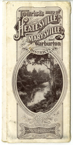
Map (Item) - Tourist Map, Tourists Resorts' Committee, Tourist's Map of Healesville Marysville and Warburton Districts, 13.10.1925
... Photo Lithographed at the Department of Lands and Survey, Melbourne by W.J. Butson./ 13.10.25......W.J. Butson...Tourist's Map of Healesville Marysville and Warburton Districts Map Tourist Map Tourists Resorts' Committee W.J. Butson ...A tourist map for Healesville, Marysville and Warburton that was produced by the Tourists Resorts' Committee. This map was produced in 1925.A tourist map for Healesville, Marysville and Warburton that was produced by the Tourists Resorts' Committee.Photo Lithographed at the Department of Lands and Survey, Melbourne by W.J. Butson./ 13.10.25healesville, marysville, warburton, victoria, tourists resorts' committee, ben cairn, mount donna buang, the black's spur, the acheron valley, narbethong, launching place, tourist information, tourism, map, tourist map -
 Marysville & District Historical Society
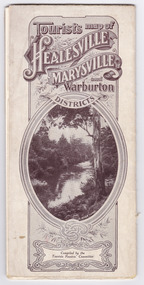
Map (Item) - Tourist Map, Tourists Resorts' Committee, Tourist's Map of Healesville Marysville and Warburton Districts, 13.10.1925
... Photo Lithographed at the Department of Lands and Survey, Melbourne by W.J. Butson./ 13.10.25......W.J. Butson...Tourist's Map of Healesville Marysville and Warburton Districts Map Tourist Map Tourists Resorts' Committee W.J. Butson ...A tourist map for Healesville, Marysville and Warburton that was produced by the Tourists Resorts' Committee. This map was produced in 1925.A tourist map for Healesville, Marysville and Warburton that was produced by the Tourists Resorts' Committee.Photo Lithographed at the Department of Lands and Survey, Melbourne by W.J. Butson./ 13.10.25healesville, marysville, warburton, victoria, tourists resorts' committee, ben cairn, mount donna buang, the black's spur, the acheron valley, narbethong, launching place, tourist information, tourism, map, tourist map -
 Stawell Historical Society Inc
Map, W.J. Butson, Subdivision of North Woodlands Estate 1922, 12.02.1922
... Parishes of Malkaff & Navarre County of Kara Kara Photlithograph by W.J Butson 12.02.2022...W.J. Butson...Stawell Historical Society Inc 46 Longfield St Stawell grampians Farming Parishes of Malkaff & Navarre County of Kara Kara Photlithograph by W.J Butson 12.02.2022 Two (2) Copies. A1 Maps with Cloth Backing Annotated with Title Holders Subdivision of North Woodlands Estate 1922 Map W.J. ...Two (2) Copies. A1 Maps with Cloth Backing Annotated with Title HoldersParishes of Malkaff & Navarre County of Kara Kara Photlithograph by W.J Butson 12.02.2022farming -
 Marysville & District Historical Society
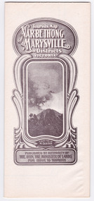
Map (Item) - Tourist Map, Department of Lands & Survey, Tourist's Map of Narbethong and Marysville Districts Victoria, 1913
... Photo Lithographed at the Department of Lands and Survey Melbourne by W.J. Butson/ 26.8.13......W.J. Butson...Tourist's Map of Narbethong and Marysville Districts Victoria Map Tourist Map Department of Lands & Survey John William Lindt W.J. Butson Albert J. Mullett ...A tourist map for the Narbethong and Marysville Districts that was originally produced by the Department of Lands & Survey in 1925.A tourist map for the Narbethong and Marysville Districts that was originally produced by the Department of Lands & Survey in 1925.Reprint of the 1925 Tourist brochure by permission R.E. Holmes Surveyor General By Authority: ALBERT J. MULLETT, Government Printer, Melbourne. Photo Lithographed at the Department of Lands and Survey Melbourne by W.J. Butson/ 26.8.13narbethong, marysville, victoria, department of lands & survey, the acheron valley, warburton, map, tourist map -
 Marysville & District Historical Society
Map (Item) - Tourist Map, Department of Lands & Survey, Tourist's Map of Narbethong and Marysville Districts Victoria, 1913
... Photo Lithographed at the Department of Lands and Survey Melbourne by W.J. Butson/ 26.8.13......W.J. Butson...Tourist's Map of Narbethong and Marysville Districts Victoria Map Tourist Map Department of Lands & Survey John William Lindt W.J. Butson Albert J. Mullett ...A tourist map for the Narbethong and Marysville Districts that was originally produced by the Department of Lands & Survey in 1925.A tourist map for the Narbethong and Marysville Districts that was originally produced by the Department of Lands & Survey in 1925.Reprint of the 1925 Tourist brochure by permission R.E. Holmes Surveyor General By Authority: ALBERT J. MULLETT, Government Printer, Melbourne. Photo Lithographed at the Department of Lands and Survey Melbourne by W.J. Butson/ 26.8.13narbethong, marysville, victoria, department of lands & survey, the acheron valley, warburton, map, tourist map -
 Wycheproof & District Historical Society Inc.
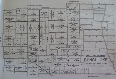
Bunguluke Map, Bunguluke District In 1923, 27.2.1923
... Marked - Photo Lithographed by W.J. Butson 27.2.1923. The details include numbers of allotments, property owners, roads, rivers. ...The Lands Department and Survey, Melbourne by W.J. Butson...Bunguluke District In 1923 Bunguluke Map The Lands Department and Survey, Melbourne by W.J. Butson ...By 1881 Bunguluke was a small settlement as recorded, December 5, in the Charlton "Mercury". It reports that in that year Draper's Store, Hotel and Post Office and residence at Bunguluke North was totally destroyed by fire. For years now there has been little sign of community life with houses few and far between and acreages have gone into larger holdings. The map references land blocks and owners for that era.This important map shows the local land ownership and local features that existed in 1923. This is a photocopied black and white map of Bunguluke in the County of Kara Kara, Number L5149. Marked - Photo Lithographed by W.J. Butson 27.2.1923. The details include numbers of allotments, property owners, roads, rivers. The boundaries marked are the Parish of Jeruk, Parish of Wycheproof, Parish of Cooroopajerrup. Wycheproof township location is shown with the Scale of Chains. Bunguluke maps for other years are also in the collection.map, bunguluke, jeruk, wycheproof, cooroopajerrup -
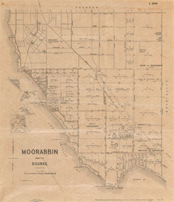 Bayside Gallery - Bayside City Council Art & Heritage Collection
Map, Department of Crown Lands and Survey et al, Moorabbin, County of Bourke, Government Roads, 1920
... The cadastral map of the Parish of Moorabbin in Victoria (L.6104) is photolithographed at the Department of Lands and Survey by W.J. Butson. It is printed in black ink on cream paper and shows street names, subdivision of blocks, sizes of the blocks and the names of the landowners, and the government roads are coloured in red pencil. ......W.J. Butson...Moorabbin, County of Bourke, Government Roads Map map Department of Crown Lands and Survey W.J. Butson ...The cadastral map of the Parish of Moorabbin in Victoria (L.6104) shows parish boundaries and land ownership 1920 when Sandringham was a Town. The government roads have been coloured in red pencil.moorabbin, county of bourke, map, plan, land subdivision, land titles, foreshores, hampton, beaumaris, highett, cheltenham, department of lands and survey, land owners, cartographic material, brighton, sandringham, town of sandringham, government roads -
Bendigo Historical Society Inc.
Map - PANNOOMILLOO : COUNTY OF BENDIGO, 17-12-13
... Photo-Lithographed at the Department of Lands and Survey, Melbourne by W.J. Butson 17-12-13, Price 1/-. (number 82 in map cupboard 1)...W.J. Butson....History House 11 Mackenzie Street Bendigo goldfields MAP Bendigo pannoomilloo W.J. Butson. Map. Pannoomilloo, County of Bendigo, Pannoobamawm, Warragamba, Milloo, Diggorra. ...Map. Pannoomilloo, County of Bendigo, Pannoobamawm, Warragamba, Milloo, Diggorra. Photo-Lithographed at the Department of Lands and Survey, Melbourne by W.J. Butson 17-12-13, Price 1/-. (number 82 in map cupboard 1)W.J. Butson.map, bendigo, pannoomilloo -
Bendigo Historical Society Inc.
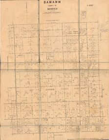
Map - BAMAWM : COUNTY OF BENDIGO, 19-8-24
... Photo-Lithographed at the Department of Lands and Survey, Melbourne by W.J. Butson, 19-8-24, Price 1/-. (number 50 in map cupboard 1)...W.J. Butson...History House 11 Mackenzie Street Bendigo goldfields MAP Bendigo bamawm W.J. Butson Map. Bamawm, County of Bendigo, Turrumberry, Pannoobamawm, Diggorra, Ballendella, Millewa. ...Map. Bamawm, County of Bendigo, Turrumberry, Pannoobamawm, Diggorra, Ballendella, Millewa. Photo-Lithographed at the Department of Lands and Survey, Melbourne by W.J. Butson, 19-8-24, Price 1/-. (number 50 in map cupboard 1)W.J. Butsonmap, bendigo, bamawm -
Bendigo Historical Society Inc.
Map - TALAMBE : COUNTY OF BENDIGO, 21-3-27
... Photo-Lithographed at the Department of Lands and Survey, Melbourne, by W.J. Butson 21-3-27, Price 2/-. (number 27 in map cupboard 1)...W.J. Butson...History House 11 Mackenzie Street Bendigo goldfields MAP Bendigo talambe W.J. Butson Map. Talambe, County of Bendigo, Hayanmi, Calivil, Pompapiel, Yallook, Tandarra, Dingee. ...Map. Talambe, County of Bendigo, Hayanmi, Calivil, Pompapiel, Yallook, Tandarra, Dingee. Photo-Lithographed at the Department of Lands and Survey, Melbourne, by W.J. Butson 21-3-27, Price 2/-. (number 27 in map cupboard 1)W.J. Butsonmap, bendigo, talambe -
Bendigo Historical Society Inc.
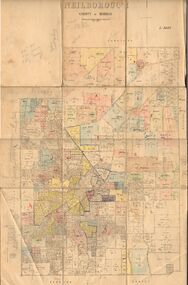
Map - NEILBOROUGH : COUNTY OF BENDIGO, 13-10-27
... Neilborough, County of Bendigo, Tandarra, Whirrakee, Huntly, Nerring, Yarraberb, Yallook, Photo-Lithographed at the Department of Lands and Survey, Melbourne by W.J. Butson 13-10-27, Price 1/- (number 77 in map cupboard 1)...W.J. Butson....History House 11 Mackenzie Street Bendigo goldfields MAP Bendigo neilborough W.J. Butson. Map. Neilborough, County of Bendigo, Tandarra, Whirrakee, Huntly, Nerring, Yarraberb, Yallook, Photo-Lithographed at the Department of Lands and Survey, Melbourne by W.J. ...Map. Neilborough, County of Bendigo, Tandarra, Whirrakee, Huntly, Nerring, Yarraberb, Yallook, Photo-Lithographed at the Department of Lands and Survey, Melbourne by W.J. Butson 13-10-27, Price 1/- (number 77 in map cupboard 1)W.J. Butson.map, bendigo, neilborough -
Bendigo Historical Society Inc.
Map - EPPALOCK : COUNTY OF BENDIGO, 2-11-14
... Photo-Lithographed at the Department of Lands and Survey, Melbourne by W.J. Butson, 2-11-14. Price 1/-. (number 39 in map cupboard 1)...W.J. Butson....History House 11 Mackenzie Street Bendigo goldfields MAP Bendigo eppalock W.J. Butson. Map. Eppalock, County of Bendigo,Lyell, Sedgwick, Strathfieldsaye, Axedale, Knowsley, Kimbolton. ...Map. Eppalock, County of Bendigo,Lyell, Sedgwick, Strathfieldsaye, Axedale, Knowsley, Kimbolton. Photo-Lithographed at the Department of Lands and Survey, Melbourne by W.J. Butson, 2-11-14. Price 1/-. (number 39 in map cupboard 1)W.J. Butson.map, bendigo, eppalock -
Bendigo Historical Society Inc.
Map - COSTERFIELD : COUNTY OF BENDIGO, 31-10-12
... Photo-Lithographed at the Department of Lands and Survey, Melbourne, by W.J .Butson 31-10-12 price 1/-. (number 93 in map cupboard 1)...W.J. Butson...Photo-Lithographed at the Department of Lands and Survey, Melbourne, by W.J .Butson 31-10-12 price 1/-. (number 93 in map cupboard 1) Map COSTERFIELD : COUNTY OF BENDIGO. ...Map. Costerfield, County of Bendigo, County of Dalhousie, Dargile, Moorambool West, Warrowitue, Heathcote, Town of Costerfield. Photo-Lithographed at the Department of Lands and Survey, Melbourne, by W.J .Butson 31-10-12 price 1/-. (number 93 in map cupboard 1)W.J. Butsonmap, bendigo, costerfield -
Bendigo Historical Society Inc.
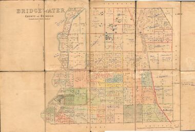
Map - BRIDGEWATER : COUNTY OF BENDIGO, 6-10-27
... Photo-Lithographed at the Department of Lands and Survey Melbourne by W.J. Butson, 6-10-27. Price 1/-. (number 53 in map cupboard 1)...W.J. Butson...Photo-Lithographed at the Department of Lands and Survey Melbourne by W.J. Butson, 6-10-27. Price 1/-. (number 53 in map cupboard 1) Map BRIDGEWATER : COUNTY OF BENDIGO. ...Map. Bridgewater, County of Bendigo, Inglewood, Salisbury, Derby, Leichardt, Yarraberb, Yarrayne, Bullock Creek, Loddon River, Sandhurst and Inglewood Railway. Photo-Lithographed at the Department of Lands and Survey Melbourne by W.J. Butson, 6-10-27. Price 1/-. (number 53 in map cupboard 1)W.J. Butsonmap, bendigo, bridgewater -
Bendigo Historical Society Inc.
Map - RUNNYMEDE : COUNTY OF BENDIGO, 8-12-13
... Photo-Lithographed at the Department of Lands and Survey, Melbourne by W.J. Butson.8-12-13. Price 1/-. (number 107 in map cupboard 1)...W.J. Butson...Photo-Lithographed at the Department of Lands and Survey, Melbourne by W.J. Butson.8-12-13. Price 1/-. (number 107 in map cupboard 1) Map RUNNYMEDE : COUNTY OF BENDIGO ...Map. County of Bendigo, County of Rodney, Burnewang, Elmore, Nolan, Campaspe, Colbinabbin, Burramboot, Corop, Township of Runnymede, Campaspe River, Mount Pleasant Creek. Photo-Lithographed at the Department of Lands and Survey, Melbourne by W.J. Butson.8-12-13. Price 1/-. (number 107 in map cupboard 1)W.J. Butsonmap, bendigo, runnymede -
Bendigo Historical Society Inc.
Map - ROCHESTER WEST : COUNTY OF BENDIGO, 30-10-12
... Photo-lithographed at the Department of Lands and Survey, Melbourne, by W.J. Butson 30-10-12. Price 1/-. (number 22 in map cupboard 1)...W.J. Butson, Government Printer....History House 11 Mackenzie Street Bendigo goldfields MAP Bendigo rochester west W.J. Butson, Government Printer. Map. Rochester West, County of Bendigo, Ballendella, Giggorra, Township of Rochester. ...Map. Rochester West, County of Bendigo, Ballendella, Giggorra, Township of Rochester. Campaspe River. Photo-lithographed at the Department of Lands and Survey, Melbourne, by W.J. Butson 30-10-12. Price 1/-. (number 22 in map cupboard 1)W.J. Butson, Government Printer.map, bendigo, rochester west -
Bendigo Historical Society Inc.
Map - POMPAPIEL : COUNTY OF BENDIGO, 1-10-27
... Photo-Lithographed at the Dept. of Lands and Survey Melbourne by W.J. Butson 1-10-27. Price 1/-. (number 85 in map cupboard 1)...W.J. Butson...Photo-Lithographed at the Dept. of Lands and Survey Melbourne by W.J. Butson 1-10-27. Price 1/-. (number 85 in map cupboard 1) Map POMPAPIEL : COUNTY OF BENDIGO. ...Map. Pompapiel, County of Bendigo, Calivil, Talambe, Yallook, Salisbury, Yarrayne, Janiember East, Waranga Mallee Channel, Blind Creek, Judyong Creek, Bullock Creek. Photo-Lithographed at the Dept. of Lands and Survey Melbourne by W.J. Butson 1-10-27. Price 1/-. (number 85 in map cupboard 1)W.J. Butsonmap, bendigo, pompapiel -
Bendigo Historical Society Inc.
Map - POMPAPIEL : COUNTY OF BENDIGO, 1-10-27
... Photo-Lithographed at the Department of Lands and Survey by W.J. Butson, 1-10-27. Price 1/-. (number 84 in map cupboard 1)...W.J. Butson....Photo-Lithographed at the Department of Lands and Survey by W.J. Butson, 1-10-27. Price 1/-. (number 84 in map cupboard 1) Map POMPAPIEL : COUNTY OF BENDIGO. ...Map. Pompapiel, County of Bendigo, Calivil, Talambe, Yallook, Salisbury, Yarrayne, Janiember East, Waranga Mallee Channel, Judyong Creek.Pompapiel Creek, Bullock Creek, Blind Creek. Photo-Lithographed at the Department of Lands and Survey by W.J. Butson, 1-10-27. Price 1/-. (number 84 in map cupboard 1)W.J. Butson.map, bendigo, pompapiel -
Bendigo Historical Society Inc.
Map - POMPAPIEL : COUNTY OF BENDIGO, 1-10-27
... Photo-Lithographed at the Department of Lands and Survey, Melbourne by W.J. Butson, 1-10-27, Price 1/-. (number 4 in map cupboard 1)...W.J. Butson, Government Printer...Photo-Lithographed at the Department of Lands and Survey, Melbourne by W.J. Butson, 1-10-27, Price 1/-. (number 4 in map cupboard 1) Map POMPAPIEL : COUNTY OF BENDIGO ...Map. Pompapiel, County of Bendigo, Calivil, Janiember East, Yarrayne, Salisbury, Yallook, Talambe, Judyong Creek, Bullock Creek, Pompapiel Creek, Edeyrn Estate. Photo-Lithographed at the Department of Lands and Survey, Melbourne by W.J. Butson, 1-10-27, Price 1/-. (number 4 in map cupboard 1)W.J. Butson, Government Printermap, bendigo, pompapiel -
Bendigo Historical Society Inc.
Map - PANNOOBAMAWM : COUNTY OF BENDIGO, 7-9-15
... Photographed at the Deptartment of Lands and Survey, Melbourne. By W.J. Butson 7-9-15. Price 1/-. (number 81 in map cupboard 1)...W.J. Butson, Government Printer, Melbourne....History House 11 Mackenzie Street Bendigo goldfields MAP Bendigo pannoobamawm W.J. Butson, Government Printer, Melbourne. Map. ...Map. Pannoobamawm, County of Bendigo, Terrick Terrick East, Wanurp, Pannoomilloo, Bamawm,Turrumberry. By authority Albert J. Mullett, Government Printer, Melbourne. Photographed at the Deptartment of Lands and Survey, Melbourne. By W.J. Butson 7-9-15. Price 1/-. (number 81 in map cupboard 1)W.J. Butson, Government Printer, Melbourne.map, bendigo, pannoobamawm -
Stawell Historical Society Inc
Map, Department of Lands and Survey Melbourne, Swinton Estate. Parish of Riachella. County of Borong, 3-08-1921
... W.J. Butson 3-8-21...Stawell Historical Society Inc 46 Longfield St Stawell grampians Shows part of Warranook Trainway Farming W.J. Butson 3-8-21 A1 Printed Map With Cloth Backing. ...Shows part of Warranook TrainwayA1 Printed Map With Cloth Backing. Annotations in Red Ink W.J. Butson 3-8-21farming -
 Federation University Historical Collection
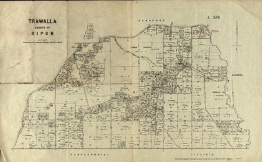
Parish Plan, Parish Plan of Trawalla in the Parish of Rippon, 1913, 28/4/1913
... ...w.j. butson...Trawalla is surrounded by Beaufort, Brewster, Lillirie, Yangerahwill and Eurambee. trawala ripon westbrok simson mackenzie mcarthur wilson nicholason gibb read hayward topper foreman bell mcmillan halpin davis goldsmith trawalla pre-emptive right butson w.j. butson m4471 w. read c.a. foreman j. simson a. goldsmith trawalla g. topper Parish Plan of Trawalla in the Parish of Rippon. ...Trawalla is surrounded by Beaufort, Brewster, Lillirie, Yangerahwill and Eurambee.Parish Plan of Trawalla in the Parish of Rippon. trawala, ripon, westbrok, simson, mackenzie, mcarthur, wilson, nicholason, gibb, read, hayward, topper, foreman, bell, mcmillan, halpin, davis, goldsmith, trawalla pre-emptive right, butson, w.j. butson, m4471, w. read, c.a. foreman, j. simson, a. goldsmith, trawalla, g. topper -
 Bendigo Historical Society Inc.
Map - JACK FLYNN COLLECTION: EDDINGTON, 1.12.1925
... Dept of Lands and Survey Melbourne by W.J. Butson 1.12.25...History House 11 Mackenzie Street Bendigo goldfields MAP Talbot parish plan Eddington Counties of Talbot Gladstone Dept of Lands and Survey Melbourne by W.J. Butson 1.12.25 Map: Parish of Eddington, Counties of Gladstone and Talbot. ...Map: Parish of Eddington, Counties of Gladstone and Talbot. Parish plan.Dept of Lands and Survey Melbourne by W.J. Butson 1.12.25map, talbot, parish plan, eddington, counties of talbot, gladstone -
 Bendigo Historical Society Inc.
Map - JACK FLYNN COLLECTION: BRIDGEWATER, 6/10/1927
... Photo Lithographed at the Department of Lands and Survey, Melbourne by W.J. Butson....History House 11 Mackenzie Street Bendigo goldfields MAP Bendigo parish plan Bridgewater Photo Lithographed at the Department of Lands and Survey, Melbourne by W.J. Butson. Map: Bridgewater , County of Bendigo. ...Map: Bridgewater , County of Bendigo. Parish plan.Photo Lithographed at the Department of Lands and Survey, Melbourne by W.J. Butson.map, bendigo, parish plan, bridgewater -
 Bendigo Historical Society Inc.
Map - JACK FLYNN COLLECTION: NEILBOROUGH, 13/10/1927
... Photo Lithographed at the Department of Lands and Survey, Melbourne by W.J. Butson...History House 11 Mackenzie Street Bendigo goldfields MAP Bendigo parish plan Neilborough Photo Lithographed at the Department of Lands and Survey, Melbourne by W.J. Butson Map: Parish of Neilborough, County of Bendigo. ...Map: Parish of Neilborough, County of Bendigo. Parish plan.Photo Lithographed at the Department of Lands and Survey, Melbourne by W.J. Butsonmap, bendigo, parish plan, neilborough -
 Bendigo Historical Society Inc.
Map - JACK FLYNN COLLECTION: BAMAWM, 19/08/1924
... Photo Lithographed at the Department of Lands and Survey, Melbourne by W.J. Butson. 19.8.24...History House 11 Mackenzie Street Bendigo goldfields MAP Bendigo parish plan Bamawm Photo Lithographed at the Department of Lands and Survey, Melbourne by W.J. Butson. 19.8.24 Map: Parish of Bamawm, County of Bendigo. ...Map: Parish of Bamawm, County of Bendigo. Parish plan.Photo Lithographed at the Department of Lands and Survey, Melbourne by W.J. Butson. 19.8.24map, bendigo, parish plan, bamawm -
Stawell Historical Society Inc
Map, Lexington County of Borong 1910 & 1914, 1910
... McGauran 5.12.10 & W.J. Butson 24.3.14...McGauran 5.12.10 & W.J. Butson 24.3.14 A2 Parish map Lexington County of Borong 1910 & 1914 Map T.F. ...Parish to the North East of MoystonA2 Parish mapPhoto Lithographed at the Department of Lands and Survey. Melbourne by T.F. McGauran 5.12.10 & W.J. Butson 24.3.14survey -
 Bendigo Historical Society Inc.
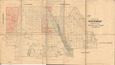
Map - JACK FLYNN COLLECTION: RAVENSWOOD, 12/12/1922
... Photo Lithographed at the Department of lands and Survey, Melbourne by W.J. Butson...Photo Lithographed at the Department of lands and Survey, Melbourne by W.J. Butson Map: Parish of Ravenswood, Counties of Bendigo and Talbot. ...Map: Parish of Ravenswood, Counties of Bendigo and Talbot. Parish plan.By Authority A.J. Mullet Government Printer Melbourne. Photo Lithographed at the Department of lands and Survey, Melbourne by W.J. Butsonmap, bendigo, parish plan, ravenswood -
 Bendigo Historical Society Inc.
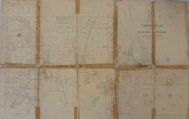
Map - JACK FLYNN MAP COLLECTION: GLADSTONE AND BENDIGO - TARNAGULLA, 13th May 1922
... Photo-Lithographed at the Department of Lands and Survey, Melbourne by W.J. Butson. 13.5.22...Photo-Lithographed at the Department of Lands and Survey, Melbourne by W.J. Butson. 13.5.22 Map 388. Counties of Gladstone and Bendigo a Map of Tarnagulla with Kingower, Glenalbyn, Inglewood, Waanyarra and Laanecoorie boarding. ...Map 388. Counties of Gladstone and Bendigo a Map of Tarnagulla with Kingower, Glenalbyn, Inglewood, Waanyarra and Laanecoorie boarding. The map is in poor condition and in several pieces. It has been previously taped together. The front page is of red card with white tape along the spine to hold it together, top half Tarnagulla is hand written in black lead on a label with blue trim.By Authority A.J. Mullett, Government Printer, Melbourne. Photo-Lithographed at the Department of Lands and Survey, Melbourne by W.J. Butson. 13.5.22map, bendigo, tarnagulla, tarnagulla, kingower, glenalbyn, laanecoorie, inglewood. -
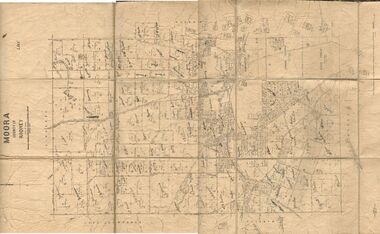 Bendigo Historical Society Inc.
Map - JACK FLYNN COLLECTION: MOORA, 9/10/22
... Photo Lithographed at the Dept, of Lands and Survey, Melbourne by W.J. Butson. 3.10.22...Photo Lithographed at the Dept, of Lands and Survey, Melbourne by W.J. Butson. 3.10.22 Map: Parish of Moora, County of Rodney. ...Map: Parish of Moora, County of Rodney. Parish plan.By Authority A.J. Mullet Government Printer Melbourne. Photo Lithographed at the Dept, of Lands and Survey, Melbourne by W.J. Butson. 3.10.22map, rodney, parish plan, moora