Showing 195 items matching water supply victoria
-
 Phillip Island and District Historical Society Inc.
Book, Arnall & Jackson, Victorian Municipal Directory, 1924, 1956
... government water supply registers Arnall & Jackson ...Subtitle varies.cities, towns, victoria, directories, municipal government, water supply, registers -
 Greensborough Historical Society
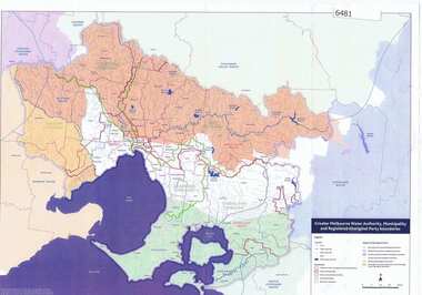
Maps, Greater Melbourne Water Authority, Municipality and Registered Aboriginal party Boundaries, 18/07/2018
... victoria water supply melbourne water Melbourne Water ...Shows Melbourne Water and Municipal area boundaries, with boundaries of registered aboriginal parties, in central Victoria.Printed in colour one sideMap reference 20180746aborigines victoria, water supply, melbourne water -
 Greensborough Historical Society
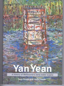
Book, Public Records Office Victoria et al, Yan Yean: a history of Melbourne's early water supply, by Tony Dingle and Helen Doyle, 2003_
... reservoir water supply Public Records Office Victoria Helen Doyle ...Formation of Yan Yean Reservoir and its part in Melbourne's water supply system128 p. paperback, black and white and colour illus.yan yean reservoir, water supply -
 Greensborough Historical Society
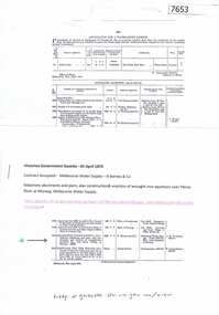
Article - Journal - Excerpt, Victorian Government Gazette, Melbourne water supply 1879, 25/04/1879
An historical account from the Victorian Government Gazette 25/04/1879: Contract accepted - Melbourne Water Supply - B. Barnes & Co. Masonry abutments and piers, also construction and erection of wrought iron aqueduct over Plenty River at Morang. 5250 pounds.History of the Maroondah aqueduct1 p., photocopy of article, downloaded from State Library of Victoriamelbourne water, mmbw, maroondah aqueduct, plenty river -
 Greensborough Historical Society
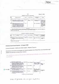
Article - Journal - Excerpt, Victorian Government Gazette, Melbourne water supply 1890, 15/08/1890
An historical account from the Victorian Government Gazette 15/08/1890: Contract accepted - Melbourne Water Supply - Mephan Ferguson. Manufacture and erection of wrought iron tubular aqueduct over Plenty River near Greensborough. Addition and extension to Watts River Scheme.History of the Maroondah aqueduct1 p., photocopy of article, downloaded from State Library of Victoriamelbourne water, mmbw, maroondah aqueduct, plenty river, watts river -
Federation University Historical Collection
Document, Zelda Martin, Confirmation of Candidature - Central Victorian Towns - Boom or Bust, c1996
Zelda Martin was a PhD candidate at the University of Melbourne. Zelda had a Bachelor of Commerce (majoring in Economic History and Economic Geography), an Master of Arts (in Politics) and a Diploma of Education; all from the University of Melbourne. Zelda is the author of a book titled " Australia's Relations with the Third World in the context of negotiations for a new international commodity order in the 1970's: continuity or change?" Pub. [Parkville, Victoria]: University of Melbourne, 1982.Eleven page article on Victorian goldfields town. The article was written during the author's PhD study. zelda martin, victorian goldfield towns, bendigo, castlemaine, ballarat, maldon, stawell, ararat, maryborough, creswick, avoca, heathcote, banks, bank of australasia, union bank of australia, government camp, sandhurst, water supply, tarnagulla, talbot, back creek, mountain creek, police court, carisbrook, dunolly, thompson's foundry -
Federation University Historical Collection
Document, Zelda Martin, Central Victorian Goldmining towns - Boom Towns or Ghost Towns?, c1996
Zelda Martin was a PhD candidate at the University of Melbourne.[.1] 4th item in light blue display book titled Research Approach/Overview of Chapters/Confirmation of Canditure/Chapters1,2,3&4 of proposed thesis. *Twenty-seven page article on Victorian goldfields towns titled: Central Victorian Goldmining Towns - Boom Towns or Ghost Towns. The article was written during the author's PhD study. It outlines the context methodology, and resources and the chapters of the proposed thesis: (1) Central Victorian Goldmining Towns - The Context (2) Contemporary Views of the Factors Necessary for Town Growth (3) Outward Manifestations of Town Growth (4) The Trappings of Government (5-9) The Main Towns and Their Hinterland. [.2] 5th item in Light Blue display book as above item. *Chapter 1 of proposed thesis titled 'Pick, Shovel and Tin Dish Mining.' Covers in Section A: Central Victoria - Pre 1851: Aborigines in Central Victoria, Squatters, and Government. Section B: The years 1851-1854: The Early Gold Rushes, Government Reaction, Township Surveys, Legislation, Town Development, Local Government and Early Settlement. [.3] 6th item in Light Blue display book as above item. *2A of proposed thesis titled 'Contemporary Views of the Factors Necessary for Town Growth'. Similar information to Chapter 1 plus extra re towns and maps. Sections: Introduction, Context of Place - Geographical Towns Listed, The Context of Time - Pre1851 Aborigines, Governance of Port Phillip, The Squatters, The Villages of Central Victorian Highlands, Conclusion, Condensed Version of Chapter2B. [.4] 7th item in Light Blue display book as above item. *Chapter2B of proposed thesis. Sections: Area of Research, Schools, Banks, Newspapers, Progress Association, Town Development - Sandhurst (Bendigo), Ballarat, Castlemaine,, Maryborough, Ararat and Stawell. [.5] 8th item in Light Blue display book as above item. *Chapter 3 of proposed thesis titled 'Outward Manifestations of Town Growth'. Sections: Introduction, Contemporary Writing, Educationalists, The Bankers, The Townsfolk, Current Theory, General Theories of Urban Development, and Conclusion. [.6] 9th item in Light Blue display book as above item. *Chapter 4 of proposed thesis titled 'Trappings of Government' Sections: Introduction, Early Government Attitudes to Mining and Town Development, Law and Order, Township Surveys, Legislation, Local Government, Transport and Communication, The People and Lobbyists. [.7] 10th item in Light Blue display book as above item. *'The Rise and Fall of Central Victorian Goldmining Towns'. Includes a map showing main Goldfields, a table showing towns and villages at two points in time - 1857 and 1871; a Bibliography of Primary and Secondary Sources. [.8] Resource No1. Black display book titled Local Towns 1 : Alma: *Brief history *Directory *Maps Amphitheatre / Mountain Hut: *Brief History Post Office Directory Ararat: *Brief History *Post Office Directory 1869 - Alphabetical Listing by Occupation *Ararat - Prominent Citizens of 1858 *Langi-Morgala Museum Avoca: *Brief History *Excerpts from 'Avoca The Early Years', Margery and Betty Beavis; pg1 - Beginnings; pg11 - The Midas Touch; pg25 - Local Gold Escorts; pg27 - A Town is Born; pg51- The Administration of Justice; pg53 - The Ways of the Law; pg61 - News of the Day; pg65 - A Time to Play; pg72 - Land Ownership *Post Office Directory (Bailliere's) 1869 *Tourism Map and Information of area *Historic Avoca - A 5.5km Tour *Avoca & the Pyrenees Region - information pamphlet Ballarat: *Early History of Ballarat - Ballarat Historical Society, Publication No.1: origin of the name; Ballaarat - the Beginning; Fabulous Yields from the Ballaarat Goldfield; *Streetscape Lydiard Street. *Hand drawn map showing Leigh River, Old Portland Bay Road, plaque on road to Colac; etc. *Newspaper article re 'The Theatre Royal' ( which stood in the vicinity of the current Owen Williams store) - 'The News'15/04/1998 *Article - 'Ballarat's Mechanics' Institute Lives On' Ballarat Courier, 14/09/1985 *Article - Standing the Test of Time' The News 17/11/1993 re The Mechanics Institute & picture of the Reading Room *'Ballarat a Study of a City, Phyllis Reichl, pub. Nelson, 1968; no.3 place, time and people field studies series *Investigator Vol.33 No.2, 1998 Geelong Historical Society. Article on pg75 describes Ballarat in 1861 *Folded poster - 'Ballarat 100' a history of telegraph communication, pub. Telecom. Beaufort (Fiery Creek): *Brief history *Post Office Directory [.9] Resource No.2 Black Folder Titled Towns cont.No2 Bendigo (Sandhurst): *'Family & Local History at the Bendigo Library - 1851-2001 150 years of gold'. *Bendigo Government Camp in 1853 illustration; key to sketch and names of Government officers stationed there *Excerpts from 'Bendigo and Vicinity' Adolph Haman *The Bendigo Goldfield Registry - pgs 1-7 Introduction *Excerpt: 'Breaking the Grip' *Excerpt: The Most Go-Ahead Place *Excerpts from 'History of Bendigo' - anti license agitation; laying out of town; proposed railway; gold calls and dividends; the Sandhurst Municipality; journalism *Bibliography Blackwood: *Excerpts from 'Aspects of Early Blackwood - The Goldfield, the Landmarks, the Pioneers' Alan J Buckingham and Margaret F Hitchcock, JG Publishing,1980 Buninyong: *A Brief History *Investigator Vol1 No.2 Feb 1966 Geelong Historical Society. Pg3 - Article re gold escort route - Mt Alexander to Adelaide - (see a simple monument on the Western Highway a few miles out of Horsham. Pg 15 - Ballarat Excursion - re the finding of gold. *Three articles published by Buninyong and District Historical Society Inc: (Magpie Exploration; Finding Gold In The Green Hills; Magpie Exploration; Burnt Bridge to Cargarie to Mt Mercer) *Copies of newspaper articles/items *Buninyong Street Directory Carisbrook: *In the Beginning There Was Carisbrook *The History of the Carisbrook Racecourse Carngham / Snake Valley: *Brief History *Directory Castlemaine: *Directory 1865-1866 - Alphabetical and Street *Poster - Castlemaine A Contemporary Guide "The Great Centre" 1866 - A Contemporary Guide to the Fascinating Past *Pamphlet - Castlemaine District Community Hospital *Map - Castlemaine, Maldon & Surrounding Districts *Map and Information - The Dry Diggings Track - a 55kl walk among historic goldfields relics ( Castlemaine Fryerstown Vaughan Mt Franklin Hepburn Daylesford) *Postcard - Former Court House *Directory 1867 - Alphabetical, Trade [.10] Resource No.3 Grey folder Titled Towns 3 Creswick to Maryborough Creswick: *Brief History *Booklet - "Creswick Cemetery Walk" *Booklet - The Buried Rivers of Gold Heritage Trail Creswick *Creswick Historical Museum Information Sheet *Chronological History of Creswick *Alphabetical Directory of the Borough of Creswick *Creswick's Creek Directory 1856 *Historic Creswick Walking Tour *A Brief Account of the Schools of Creswick - Past and Present *100 Years of Railway Travel in Creswick *The Berry Deep Leads *The Spence Home at Jackass Gully in the Creswick State Forest ( William Guthrie Spence - Pioneer) *The New Australian Mine and the 1882 Disaster *Creswick District News, Issue 7, July August 1999 *The Creswick Miners Walk - Information and Map *Maps Chewton: *Brief History *Directory Clunes: *Brief History *Clunes Street Directory Daylesford: *Brief History *Notable Bushfires in Daylesford District Over More Than a Century - "Black Thursday" 1851; 1862; 1899; the Disastrous Hepburn Fire of 1906; 1939; 1944; 1969. *Post Office Directory -Daylesford and Hepburn Dunolly / Inkerman: *Brief History *Directory *Pamphlet - Goldfields Historical Museum *Pamphlet - Historic Dunolly - Victoria's Best Kept Secret *Map of Gold Workings at Dunolly Area - showing where the main gold rushes occurred *Brief History - Inglewood *Directory - Inglewood - Name Occupation, Dwelling Kingower: *Brief History *Directory - Name / Ocupation / Dwelling Linton / Happy Valley / Piggoreet: *Brief History *Directory - Lintons McIvor: *"A History of the Shire and the Township of Heathcote" by J.O. Randell Majorca: *Brief History *Official Post Office Directory 1869 - Name / Occupation/ Address Maldon (Tarrangower): *Brief History Part 1 *Brief History Part 2 *Post Office Directory *List - Alphabetical Order by Names plus Business and Trade (Tarrangower Times Oct/1858) *List - Alphabetical Order by Trade plus Name and Business *Directory - Name / Occupation / Dwelling Maryborough: *Worsley Cottage - built by Arthur Worsley, a contractor in stonework in 1894 [.11] Resource No. 4 Blue Display Book titled Towns 4 Moliagul to Stawell Moliagul: *Brief History *Moligul Legislative Assembly (Voting?) List - Names and Occupations *Moliagul Victorian Post Office Directory 1868 - Name / Ocupation / Address / Comments *"The Welcome Stranger" gold nugget *The Sunday School *The Welcome Stranger Discovery Walk - information and map Moonambel (Mountain Creek) Redbank *Brief History *List of names extracted from advertisments of the Pioneer and Mountain Creek Advertiser 16/02/1861. *Bailliere's Directory 1869 - Alphabetical List of Name / Occupation / Place St Arnaud: *Brief History Sebastapol: *Brief History *Directory 1869 - Alphabetical by Name; plus occupation and address. Browns and Scarsdale: *Brief History *Browns Street Directory - Name and Occupation Smythesdale: *Brief Description *Smythesdale Street Directory -Name and Occupation Stawell (Pleasant Creek) *Brief History *Victorian Official Post Office Directory - Name /Occupation / Dwelling *Chronology - 1841-1920 *Production of gold statistics - 1879 - 1900 *Big Hill *Extracts from "The Golden Years of Stawell". Chapt 1 - Stawell's Coming Out. Capt. 2 - The Gold Rush. Caapt.3 - Cradle of Democracy. Chapt.4 - The Reefs Becomes Stawell. Chapt. 5 - Rushing In. Chapt.6 - The Pioneers. Chapt 7 - The Decade of Optimism. [.12] Resource No. 5: Blue Display Book titled 'Towns Steiglitz to the The Golden Triangle. Steiglitz: Brief History Victorian Post Office Directory 1869 *Map of Steiglitz *List of maps relevant to Steiglitz history *Information 6 tables of data from "Reports of Mining Surveyors Talbot (Back Creek) Brief History Taradale: Post office Directory 1869 - Name/Occupation/Street. Also list in alphabetical order by Occupation Taradale *Chronological Reference to Taradale Mines *Water - The Coliban System of Waterworks *Joseph Brady *The Syphon Tarnagulla (Sandy Creek) *Brief History *Tarnagulla Businessmen Cameos to give depth to advertisments in 'The Tarnagulla Courier' various issues 1864-1871 *Directory - Name/Occupation /Address *List - Name/Business/Trade Wedderburn (Koorong) *Brief History *List - Name/Occupation The Golden Triangle: *The Early Rushes - Wedderburn / Moliagul / Sandy Creek - Tarnagulla / Jones Creek - Waanyarra / Kingower / Dunolly - Goldsborough / Inglweood *Census of 1857 - Population / Occupations *1858-1871 - A Time of Consolidation- Wedderburn / Moliagul / Sandy Creek- Tarnagulla / Arnold *Census 1871 - Population *Information gleaned from the census data - Demographics / Population / Occupations / marital / Birthplace / Religion / Literacy/ Occupation and Housing Cameos *Graphs - Birthplace of settlers /Male-Female Ratio / Married males / Children under 15 as Percentage of Population / Religion *Census 1857 - Statistical data *Maps *Bibliography [.13] Resource No. 6 - Black Display Book Information and Research in Central Victoria including: *Banking - Research from ANZ Bank Archives *Institutions - also includes articles listed from the Ballarat Times Newspaper *Australian mining History Association - A.M.H.A. Bibliography *Australia's Mining History * Bibliography - Land Surveys Victoria - *1853 Administration (Statistics and Other) includes: schools / ministers of religion / police / military / local administration / licences for sale of spirits / distances between various Victorian gold fields. * Victoria Government Gazette (Copy) - N0. 116, 12/12/1854 includes: Gold Felds Commission of Enquiry & No. 85, 15/09/1854 - Addresses presented to the Lieutenant Governor (Sir Charles Hotham) during his tour through the Gold Fields of Victoria,1854. Addresses on behalf of : the people of Bendigo; Members of the Church of England, Bendigo; Members of the Wesleyan Church on the Bendigo Gold Fields; Bendigo Gold District General Hospital; the Bendigo Prospecting Association; Committee of the Bendigo Local Exhibition; Bendigo District Medical Association; Coloured Americans Resident at Bendigo; German Inhabitants of Bendigo; Landowners, Inhabitants, and Miners of Castlemaine; Inhabitants of Forest Creek; Inhabitants of Heathcote and Gold Miners of McIvor; Residents and landholders of the District of Bacchus Marsh; Inhabitants of Kilmore and Vicinity. *Gold Fields Correspondence 1853: letter from Lieutenant Colonel Valiant, (Officer commanding the Troops in Victoria) to the Lieutenant Governor re threatened disturbance at Sandhurst (Bendigo) regarding the Gold License Fee. * Extracts from a book "Victoria" re Gold Fields Commission of Enquiry involving mainly Ballarat and Castlemaine and a chapter titled 'A Tour to the Victorian Gold-Fields' *Lists of central Victorian newspapers - listed by date published 1851to 1874; by first date available to State Library. *A list of cities and towns showing County, population in 1861 &1871, and municipal status. [.14] Resource no.7. Black display book. *Reference: Papers presented to Parliament Victoria - 1859-1860 4 volumes - relevant sections copied. Contains information on Branches of Government. General / Finance / Gold / Gazette / Commission and Warrant / Statistic. *Gold Fields Act. In accordance with the Act the gold fields are divided into six districts - Ballaarat, Castlemaine , Sandhurst, Avoca, Ararat, and Beechworth.. Official staff in each gold district consists of a Resident Warden, Wardens, Wardens' Clerks, Bailiffs, Chinese Protectors, Chinese Interpreters, and Mining Surveyors. *Gold Receiver *Gaols *Police magistrates and Clerks of Petty Sessions, etc. *Field Branch *Immigration and Emigration Overland - Chinese - 1859 *Population on the Goldfields *The Geological Survey - The Government Geologist is assisited by staff from four branches - the office Branch; the Publishing Branch; the Field Branch and the Museum Branch. *Commission to Enquire Into Sludge dated 10/02/1859 (Some sections copied) - Report to the Honorable Chief Commissioner of Public Works, Melbourne re the mode of carrying the sludge from the puddling mills in Sandhurst without interfering with the drainage of the town and the roads in the neighbourhood. [.15] Resource No.8: Camel display book titled Resource No. 8. Aborigines *Lists of book titles - +"Readings in Victorian prehistory" +"The Aborigines of Port Phillip" +Aboriginal languages and clans" +"A History of the Port Phillip District" +"Langi Ghiran 1: Aboriginal Rock...." +"Koorie History: sources for aboriginal studies in the State Library of Victoria", ed. Tom Griffiths, Melb. Friends of the State Library, 1989 +"The Public Lands of Australia Felix"; settlement and land appraisal in Victoria1834-91 with special reference to the Western Plains", J.M.Powell, Melb. Oxford University Press 1970 +*Bibliography of the Victorian Aborigines' from the earliest manuscripts to 31st December 1970, Massoa, Aldo, Melb. Hawthorn Press, 1971 +"Aborigines in Colonial Victoria, 1836-1886", M.F. Christie, Sydney University Press, 1979 +"Urban and Industrial Australia: readings in Human Geography" ed J.M. Powell, Melb. Sorrett Pub. 1974 *Extracts: -Processes of Pioneer Settlement - The Squatting Occupation of Victoria, 1834-60. J.M. Powell -Areal Variations in the Class Structure of the Central-Place Hierarchy. P. Scott - Volume1 and Volume 2: Notes Relating to the Habits of the Natives of Other Parts of Australia and Tasmania. Compiled from various sources for the Government of Victoria by R Brough Smyth. John Curry, O'Neil, Melb. 1st pub. Melb. 1876. p31-45 - Numbers and Distribution of the Aborigines in Victoria -Victorian Aborigines 1835-1901 - A Resource Guide to the Holdings of the Public Record Office, Victoria; published by the Government Information Centre 1984. *History of the Aboriginal Artefacts Displayed in the Daylesford Museum. F. G. Powell (4 page pamphlet) *Letter to Zelda Martin from Peter Lovett, Cultural Officer, Ballarat & District Aboriginal Co- Operative, 05/02/1997 *Map: Ian Clarke Victorian Tribunal Boundary Map - Clans of Central Victoria. *Victorian Rock Art and Mythology - Article about Mount Langhi Ghiran and myths of the Tjapwarong people. *Two Aboriginal myths relating to the Grampians - 'The Monster Emu' / 'The Aquisition of Fire', by the Aborigines in the Grampians Areas *Article titled (chapter 8) Ballarat - information re camping sites in the region. Lake Wendouree / Lake Burrumbeet (includes a myth) / Mt Bunninyong / Lal Lal / Pitfield / Mount Elephant / Mount Egerton / Meredith / Lake Goldsmith / Lake Learmonth / Ercildoune *Notes on the Aborigines of the Wider Ballarat Region plus European names=Aboriginal names. John Morris 26/07/1995 *Role of Aborigines in Town Development in Central Victoria. Mentions Native Police Force est. in Port Phillip 1842 and Central Board for Aborigines est. 1860 *The Grave of King Billy. (Frank Wilson) Pamphlet. *Camping Places in Central and Northern Victoria. Article re Lake Burrumbeet site. *Programme for the Unveiling of Memorial Cairn for Edward Stone Parker 1802-1865. Note portrait not accurate. Accurate portrait is available in the book "A Successful Failure A Trilogy The Aborigines and Early Settlers", Edgar Morrison, Graffiti Publications, 2002. * Large envelope addressed to Mr G Netherway containing newspaper cuttings regarding the life of Edward Stone Parker, the unveiling of the Memorial Cairn as mentioned above, articles titled 'Episodes from Our Early Days' (Edgar Morrison, Yandoit)- The Black's School, A School At Last and The Final years. Also a typed page titled 'Historical Background to E.S.Parker's Career. Includes an interesting tale titled 'When the cat lay doggo' re laying power leads for the unveiling ceremony at the memorial site. [.16] green display folder titled 'Research Aids' *List of references to Commissioners' & W'ardens' Reports (formerly held at La Trobe Library Archives, now at Public Records Office [PRO]). Indicates town referred to / date of report / name of camp if different to town. * Archive information re Anglican Records *Movement around the Goldfields - Miners and Storekeepers - usefulness of newspapers in providing information - areas covered - Castlemaine, Maldon, Ararat, Stawell, Tarnagulla, Dunolly. *Port Phillip /Victoria Directories 1839/1867 - Chronological list of Directories included in this series. *"Notes on the History of Local Government in Victoria" A.W. Greig Melb. University Press 1925 - Photo-copied extract p5-p40. (Source - Deakin University Library) - Introduction by W.Harrison Moore. Section 1 - Development in New South Wales Before Separation. Section 2 - Development in Victoria After Its Separation from New South Wales. Hand written notations: 'roads, markets, and local government 1855 on' ;'opportunity of squatters in parliament' and 'opportunities of matters in parliament p33' * Notes on the Establishment of Surveyor General's Department 1851and Commissioner of Crown Lands and Survey. * Newspaper articles from The Argus, 1849, re the discovery of gold in the Pyrenees region. * Excerpt - a report on schools - A.B.Orlebar, Inspector; re the need for permanent school buildings rather than tents. *Excerpt from - 'Approaches to Urban History', Sean Glynn: The Case for Caution * Except from - 'The Urban Sprinkle', Weston Bate: Country Towns and Australian Regional History *Reference- 'The History of Land Tenure in the Colony of Victoria', John Quick. References the Haines Land Bill, land tenure and Land Leagues. [.17] Light blue envelope folder titled 'Birtchnell's Ballarat, etc. Directory 1862 *Contains various directories for Smythesdale, Buninyong, Clunes, Brown's and Creswick. [.18] Red envelope folder no.2 titled Victorian Gazetteer *Selected pages from 1869 Victorian Gazetteer on A4 paper (with a handwritten note questioning if some pages are from 1868 Victorian Gazetteer as appears to be different sizes - A3 pages.) Information includes locations and descriptions of towns, hotels, banks, communications and populations. (Does not include names, residences and occupations) [.19] Red Envelope folder titled Bailliere's Official Post Office Directory 1868 (or1869 or a mixture of both?) *Preface *Contains a selection of pages of towns highlighted in yellow in the the index *Work on this directory was commenced in 1867. *Information includes: Municipalities - mayors and councilors; lists of towns naming male inhabitants and their occupations. [.20]Yellow manila folder titled Post Grad Seminar Presentation 1996 *Gives some background to Zelda Martin's proposed thesis and why she chose the topic Gold Mining Towns Boom or Bust [.21] A3 display book - No. 1A * A list of 'Relevant Newspapers collected: The Tarrangower Times and Maldon Advertiser (first published 1858) Includes dates 1858-1867. The Mount Alexander Mail. Includes dates 1854-1866 The Tarnagulla Courier. Includes dates from1864-1871 Dunolly and Burnt Creek Express. Includes dates from 1862-1871 * Selection of newspaper pages from The Mount Alexander Mail 1854 to 1856, mostly showing advertisements for businesses and services provided to that community. [.22] A3 display book - No. 1B * Selection of newspaper pages from The Mount Alexander Mail 1857 to 1866, mostly showing advertisements for businesses and services provided to that community. [.23] A3 display book -No. 2 * Selection of newspaper pages from The Tarnagulla Courier 1864 to 1871, mostly showing advertisements for businesses and services provided to that community. [.24] A3 display book - No. 3 *Selection of newspaper pages from The Tarrangower Times (and Maldon and Newstead) Advertiser 1858 to1867, mostly showing advertisements for businesses and services provided to that community. [.25] A3 display book - No.4 * Selection of newspaper pages from The Dunolly and Burnt Creek Express; and The Dunolly and Betbetshire Express 1862 to 1871, mostly showing advertisements for businesses and services provided for that community. [.26] A3 display book - No.5 Includes: * Bryce Ross's Diggings Directory. Includes instructions for using this directory. This directory was used by "all persons having connexion or desiring to communicate with 'working parties, private friends, or Stores at the Diggings." As a directory for each area wwas completed it was published in each month's issue of Bonwick's "Digger's Magazine." Years c1852/1853. This Directory commences first at the head of Forest Creek. Includes a directory for Bendigo and Ballarat. Of interest at the end of the Bendigo and Ballarat directory is a list of the number of storekeepers, butchers, doctors, smiths, eating houses, lemonade sellers and chapels. * The Castlemaine Directory and Book of General Information Comprehending Glass's Model Calendar for the Two Years 1862 and1863. "zelda martin, victorian goldfield towns, bendigo, castlemaine, ballarat, maldon, stawell, ararat, maryborough, creswick, avoca, heathcote, banks, bank of australasia, union bank of australia, government camp, sandhurst, water supply, tarnagulla, talbot, back creek, mountain creek, police court, carisbrook, dunolly, thompson's foundry, charles clacy, anthony trollope, robert cecil, mount alexander, urbanisation, national schools, education, govenrment, industry, railway, transport, settlement, land settlement in central victoria, steiglitz, joseph brady, the new australian mine, berry deep leads, william guthrie spence, creswick state forest, arthur worsley, worsley cottage, the welcome stranger, moliagul, moonambel, redbank, st arnaud, sebastapol, brown's, scarsdale, clunes, chewton, daylesford, bushfires, inkerman, inglewood, kingower, lintons, happy valley, piggoreet, mcivor, majorca, tarrangower, taradale, the coliban system, the syphon, sandy creek, wedderburn, koorong, arnold, jones creek, waanyarra, the golden triangle, census 1857, blackwood, buninyong, durham lead, magpie, carngham, snake valley, alma, amherst, daisy hill, amphitheatre, mountain hut, beaufort, fiery creek, counties, population, gold fields commission of enquiry1854, william westgarth, gold license fee, lieutenant colonel valiant, administration of the victorian gold fields, commission to enquire into sludge 1859, e.s. parker, edward stone parker, edgar morrison, mount franklin protectorate, dja dja wurrung, memorial cairn, franklinford, mt franklin memorial cairn, jajowurrong, dja dja wurung, tjaowarong, wothowurong, assistant protectors, daylesford museum, buluk, rock art - grampians, aboriginal mythology - grampians, aborigines, first nations people, mount franklin, aboriginal artifacts, lake burrumbeet, native police force, central board of aborigines, yandoit, commissioners' reports, wardens' reports, port phillip/victoria directories 1839-1867, local government - victoria 1853/1854, surveyor general's department - 1850's, victorian schools 1850's, a.b.orlebar, haines land bill, william charles haines, wilson gray, land tenure, land leagues, victorian gazetteer, the tarrangower times and maldon advertiser - 1858-1867, the mount alexander mail 1854-1866, the tarnagulla courier 1864, dunolly and burnt creek express 1862-1871, bryce rose's diggings directory, the castlemaine directory 1862-1863 -
 Federation University Historical Collection
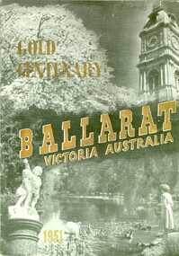
Booklet, Ballarat Victoria Australia: Gold Centenary, 1951
The book includes a brief History of Ballarat by Nathan Spielvogel.Soft covered book with many black and white images of Ballarat. It was the programme for the Ballaarat Centenary Celebrations in 1951.ballarat, centenary, ballarat state offices, ballarat art gallery, ballarat library, state electricty commission, water supply, myer woollen mill, wallace butter company -
 Federation University Historical Collection
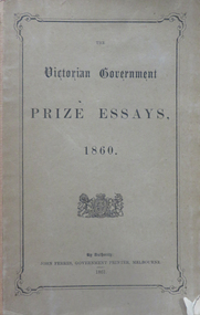
Book, John Ferres, Government Printer, Victorian Government Prize Essays 1860, 1861
Royal Society of Victoria Government prize essays Brown soft covered book with the following contents: Preface Collection and Storage of Water in Victoria by Frederick Acheson (gold washing, irrigation, motive-power, general water supply, artesian wells) Agriculture of Victoria by William Story (geological and chemical character of s oils, rotation of crops, sources and application of manures.) Origin and Distribution of Gold in Quartz Veins by Henry Rosales Development of Resources in the Colonyroyal sociey of victoria, gervernment prize essays, soils, water, agriculture, gold, quartz, henry rosales, frederick acheson, william story, charles mayes, quartz mining -
 Federation University Historical Collection
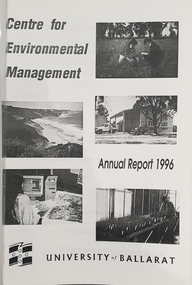
Booklet, University of Ballarat Centre for Environmental Management, 1996
The Centre for Environmental Management as established in July 1995 as a strategic development initiative to consolidate the University's position as a centre for industry linked environmenttal teaching, resarech and consultancy. Page 19 "SPECIAL INITIATIVES Establishment of field Research Stations Two areas of concentration of research effort for the Centre are the Otways in the south western Victoria and the Scotia Country in the rangelands of NSW. In both these areas it is essential that ther be a secure accomodation abase for research students. In the former case there is a need for a sheltered base to enable year round field work in cold wet conditions and in the latter a base with a reliable water supply and the facilities to allow field work in very hot dry conditions which prevail from much of the year. It has been an ibjective of the Centre to establish field stations at these two sites and considerable progress has been made through the year. (i) Nanya Field Station in the Scotial Country Through the generosity of the owner, Mr Rob Taylor, an unused homestead on Nanya Station was made available to the Centre. Largely through voluntary labour during research field trips during the year this previously derelict homestead has been restored to functionality and now has facilities for up to 20 research workers with a reliable water supply, cooking, washing, and refrigeration facilities. (ii) Cape Otway Resaerch Centre Negotiations have continued through the year with the potential lessees of the Cape Otway Lighthouse Precinct with the support of the Vice Chancellor and other potential user groups within the University these have reached a successful outcome. The University will be working with the lessees to develop the historic Telegraph Station as a dual purpose facility for interpretation and research." Black and white cover with clear plastic sheet. university of ballarat, centre for environmental management, martin westbrooke, richard mcewan, mal weston, john miller, nanya, telegraph station, cape otway, cape otway lighthouse station, cape otway telegraph station, field resaerch stations, s. hadden, peter dahlhaus, r.j. macewan, pat prevett, native vegetation assessment, fauna management, pest plants and animal research, soil and water assessment, conservation reserve management, paul ryan, richard macewan -
 Federation University Historical Collection
Book, State Electricity Commission, Serving Victoria. 50 Years of Service. State Electricity Commission of Victoria, 1969
A blue, soft, illustrated covered book.state electricity commission of victoria, anniversary, monash house, w.h. connolly, alexander fitzgerald, t.p. scott, b.j. callinan, yallourn, hazelwood power station, morwell power station, briquettes, morwell briquette works, water power, hydro-electric supply, rocky valley reservoir, electricity network, transmission statins, yallourn "w" power station, eildon reservoir -
 Federation University Historical Collection
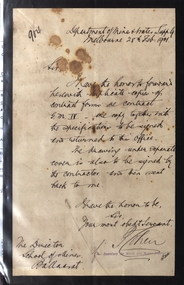
Letter, Letter from the Department of Mines and Water Supply, 1901, 28/02/1901
... for Queen Victoria. Department of Mines & Water Supply Melbourne ...Foolscap handwritten letter with black edge marking mourning for Queen Victoria. Department of Mines & Water Supply Melbourne 28th Feb. 1901 Sir, I have the honor to forward herewith duplicate copies of conrtact forms re contract G.M. IV - one copy together with the specifications to be signed and returned to this office. The drawing underneat separate cove is also to be signed by the contractor and then sent back to me. I have the honor ro be, Sir, Your most obedt Servant. P. Cohen for Secretary for Mines and Water Supplydepartme of mines and water supply, p. cohen, contract, ballarat school of mines, mourning, letterhead, queen victoria mourning -
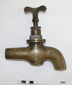 Flagstaff Hill Maritime Museum and Village
Functional object - Tap, mid-late 19th century
This type of large, brass tap is typical of the plumbing fittings manufactured in the late 19th and early 20th centuries. The tap has encrustations and concretion inside, showing that it had been in the sea for quite some time. The pipe leading to the spout is squashed, nicked and appears to have been sawn or broken off. It could have once been part of the plumbing from a ship, perhaps from one of the boilers used in the kitchen, for bathing or for laundry or cleaning. The name “BEST” on the tap signifies that it could have been made by Robert Best who began his Birmingham brass foundry c. 1840, and even though The information from the donor is that tap was given to her father (1906-1982) who lived in the Warrnambool district. It was likely given by a cray fisherman or diver, who said that the tap came from the Loch Ard shipwreck, wrecked on Mutton Bird Island, east of Port Campbell, Victoria, on 1st June 1878. This could easily be the case but there is no provenance for it. ROBERT BEST, BRASS FOUNDRY Circa 1840 Robert Best founded his brass foundry business and was referred to as a Brass Chandelier of Birmingham”. In 1864 an advertisement in the Journal of Gas Lighting, Water Supply, & Sanitary Improvement announces Best and Hobson, late Robert Best, 100 Charlotte Street Birmingham, manufacturers of Chandeliers, Brass and iron fittings, Steam and Water-cocks etc. gas apparatus of every description, Plumber's brass foundry, with works at Birmingham and Great Bridge, Staffordshire. In 1867 Best & Lloyd was formed, after Best and Hobson went into liquidation, manufacturing at the Cambray Works of Wattville Road, Handsworth. It was a light industrial engineering works and one of the owners was Robert Dudley Best’s father. Robert Dudley Best (1892-1984) later took over the business of Best & Lloyd. The company is still in business at Downing Street, Smethwick, Birmingham. In 1878, brass ship furniture and bell fittings stamped “BEST” was made by William Udal & Co., who advertised as manufacturers of BEST cast and stamped brass foundry goods. This large brass tap is typical of industrial tapware of the mid-late 19th ancenturies 20th century. The location of the tap when found is associated with the Warrnambool district and could have easily been from a shipwreck due to the encrustation found inside the tap. Due to its design and manufacturer, the tap is associated with the mid-late 19th and early 20th-century manufacture of plumbing fittings. Tap, brass, heavy-duty, with butterfly handle. The design and style are typical of the plumbing of the late 1800s. Inscription pressed into the handle, within rectangular border "BEST". Encrustation and concretion are inside the tap spout. “BEST” on one side of the tap handle (Also, a label from the donor attached to the tap “from the wreckage of the LOCH ARD")flagstaff hill, warrnambool, shipwrecked coast, flagstaff hill maritime museum, maritime museum, shipwreck coast, flagstaff hill maritime village, great ocean road, robert best brass foundry, best and hobson, best & llyod, birmingham brass foundry, brass tap, best brand tap, heavy duty brass tap, industrial brass tap, boiler tap, 19th century plumbing, 19th century tapware, 19th century plumbing fitting, tap with butterfly handle, tap salvaged from shipwreck, brass fittings, steam engine fittings, water-cock fitting -
 Flagstaff Hill Maritime Museum and Village
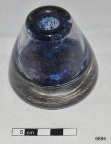
Container - Ink well, early to mid 20th century
One of the daughters of Dr Angus and his wife Gladys told Flagstaff Hill Maritime Village that this glass ink well was used by her father in his office in the days when ink powder [usually supplied in paper packets] was mixed with warm water to make ink. The ink well was donated to Flagstaff Hill Maritime Village by the family of Doctor William Roy Angus, Surgeon and Oculist. It is part of the “W.R. Angus Collection” includes historical medical equipment, surgical instruments and material once belonging to Dr Edward Ryan and Dr Thomas Francis Ryan, (both of Nhill, Victoria) as well as Dr Angus’ own belongings. The Collection’s history spans the medical practices of the two Doctors Ryan, from 1885-1926 plus that of Dr Angus, up until 1969. ABOUT THE “W.R.ANGUS COLLECTION” Doctor William Roy Angus M.B., B.S., Adel., 1923, F.R.C.S. Edin.,1928 (also known as Dr Roy Angus) was born in Murrumbeena, Victoria in 1901 and lived until 1970. He qualified as a doctor in 1923 at University of Adelaide, was Resident Medical Officer at the Royal Adelaide Hospital in 1924 and for a period was house surgeon to Sir (then Mr.) Henry Simpson Newland. Dr Angus was briefly an Assistant to Dr Riddell of Kapunda, then commenced private practice at Curramulka, Yorke Peninsula, SA, where he was physician, surgeon and chemist. In 1926, he was appointed as new Medical Assistant to Dr Thomas Francis Ryan (T.F. Ryan, or Tom), in Nhill, Victoria, where his experiences included radiology and pharmacy. In 1927 he was Acting House Surgeon in Dr Tom Ryan’s absence. Dr Angus had become engaged to Gladys Forsyth and they decided he further his studies overseas in the UK in 1927. He studied at London University College Hospital and at Edinburgh Royal Infirmary and in 1928, was awarded FRCS (Fellow from the Royal College of Surgeons), Edinburgh. He worked his passage back to Australia as a Ship’s Surgeon on the on the Australian Commonwealth Line’s T.S.S. Largs Bay. Dr Angus married Gladys in 1929, in Ballarat. (They went on to have one son (Graham 1932, born in SA) and two daughters (Helen (died 12/07/1996) and Berenice (Berry), both born at Mira, Nhill ) According to Berry, her mother Gladys made a lot of their clothes. She was very talented and did some lovely embroidery including lingerie for her trousseau and beautifully handmade baby clothes. Dr Angus was a ‘flying doctor’ for the A.I.M. (Australian Inland Ministry) Aerial Medical Service in 1928 . Its first station was in the remote town of Oodnadatta, where Dr Angus was stationed. He was locum tenens there on North-South Railway at 21 Mile Camp. He took up this ‘flying doctor’ position in response to a call from Dr John Flynn; the organisation was later known as the Flying Doctor Service, then the Royal Flying Doctor Service. A lot of his work during this time involved dental surgery also. Between 1928-1932 he was surgeon at the Curramulka Hospital, Yorke Peninsula, South Australia. In 1933 Dr Angus returned to Nhill and purchased a share of the Nelson Street practice and Mira hospital (a 2 bed ward at the Nelson Street Practice) from Dr Les Middleton one of the Middleton Brothers, the current owners of what previously once Dr Tom Ryan’s practice. Dr Tom and his brother had worked as surgeons included eye surgery. Dr Tom Ryan performed many of his operations in the Mira private hospital on his premises. He had been House Surgeon at the Nhill Hospital 1902-1926. Dr Tom Ryan had one of the only two pieces of radiology equipment in Victoria during his practicing years – The Royal Melbourne Hospital had the other one. Over the years Dr Tom Ryan had gradually set up what was effectively a training school for country general-practitioner-surgeons. Each patient was carefully examined, including using the X-ray machine, and any surgery was discussed and planned with Dr Ryan’s assistants several days in advance. Dr Angus gained experience in using the X-ray machine there during his time as assistant to Dr Ryan. When Dr Angus bought into the Nelson Street premises in Nhill he was also appointed as the Nhill Hospital’s Honorary House Surgeon 1933-1938. His practitioner’s plate from his Nhill surgery is now mounted on the doorway to the Port Medical Office at Flagstaff Hill Maritime Village, Warrnambool. When Dr Angus took up practice in the Dr Edward and Dr Tom Ryan’s old premises he obtained their extensive collection of historical medical equipment and materials spanning 1884-1926. A large part of this collection is now on display at the Port Medical Office at Flagstaff Hill Maritime Village in Warrnambool. In 1939 Dr Angus and his family moved to Warrnambool where he purchased “Birchwood,” the 1852 home and medical practice of Dr John Hunter Henderson, at 214 Koroit Street. (This property was sold in1965 to the State Government and is now the site of the Warrnambool Police Station. and an ALDI sore is on the land that was once their tennis court). The Angus family was able to afford gardeners, cooks and maids; their home was a popular place for visiting dignitaries to stay whilst visiting Warrnambool. Dr Angus had his own silk worm farm at home in a Mulberry tree. His young daughter used his centrifuge for spinning the silk. Dr Angus was appointed on a part-time basis as Port Medical Officer (Health Officer) in Warrnambool and held this position until the 1940’s when the government no longer required the service of a Port Medical Officer in Warrnambool; he was thus Warrnambool’s last serving Port Medical Officer. (Masters of immigrant ships arriving in port reported incidents of diseases, illness and death and the Port Medical Officer made a decision on whether the ship required Quarantine and for how long, in this way preventing contagious illness from spreading from new immigrants to the residents already in the colony.) Dr Angus was a member of the Australian Medical Association, for 35 years and surgeon at the Warrnambool Base Hospital 1939-1942, He served with the Australian Department of Defence as a Surgeon Captain during WWII 1942-45, in Ballarat, Victoria, and in Bonegilla, N.S.W., completing his service just before the end of the war due to suffering from a heart attack. During his convalescence he carved an intricate and ‘most artistic’ chess set from the material that dentures were made from. He then studied ophthalmology at the Royal Melbourne Eye and Ear Hospital and created cosmetically superior artificial eyes by pioneering using the intrascleral cartilage. Angus received accolades from the Ophthalmological Society of Australasia for this work. He returned to Warrnambool to commence practice as an ophthalmologist, pioneering in artificial eye improvements. He was Honorary Consultant Ophthalmologist to Warrnambool Base Hospital for 31 years. He made monthly visits to Portland as a visiting surgeon, to perform eye surgery. He represented the Victorian South-West subdivision of the Australian Medical Association as its secretary between 1949 and 1956 and as chairman from 1956 to 1958. In 1968 Dr Angus was elected member of Spain’s Barraquer Institute of Barcelona after his research work in Intrasclearal cartilage grafting, becoming one of the few Australian ophthalmologists to receive this honour, and in the following year presented his final paper on Living Intrasclearal Cartilage Implants at the Inaugural Meeting of the Australian College of Ophthalmologists in Melbourne In his personal life Dr Angus was a Presbyterian and treated Sunday as a Sabbath, a day of rest. He would visit 3 or 4 country patients on a Sunday, taking his children along ‘for the ride’ and to visit with him. Sunday evenings he would play the pianola and sing Scottish songs to his family. One of Dr Angus’ patients was Margaret MacKenzie, author of a book on local shipwrecks that she’d seen as an eye witness from the late 1880’s in Peterborough, Victoria. In the early 1950’s Dr Angus, painted a picture of a shipwreck for the cover jacket of Margaret’s book, Shipwrecks and More Shipwrecks. She was blind in later life and her daughter wrote the actual book for her. Dr Angus and his wife Gladys were very involved in Warrnambool’s society with a strong interest in civic affairs. He had an interest in people and the community They were both involved in the creation of Flagstaff Hill, including the layout of the gardens. After his death (28th March 1970) his family requested his practitioner’s plate, medical instruments and some personal belongings be displayed in the Port Medical Office surgery at Flagstaff Hill Maritime Village, and be called the “W. R. Angus Collection”. The W.R. Angus Collection is significant for still being located at the site it is connected with, Doctor Angus being the last Port Medical Officer in Warrnambool. The collection of medical instruments and other equipment is culturally significant, being an historical example of medicine from late 19th to mid-20th century. Dr Angus assisted Dr Tom Ryan, a pioneer in the use of X-rays and in ocular surgery. Ink well, thick clear glass, bell shaped, wide and heavy base. Remnants of blue ink inside. Part of the W.R. Angus Collection.flagstaff hill, warrnambool, shipwrecked coast, flagstaff hill maritime museum, maritime museum, shipwreck coast, flagstaff hill maritime village, great ocean road, dr w r angus, dr ryan, surgical instrument, t.s.s. largs bay, warrnambool base hospital, nhill base hospital, mira hospital, flying doctor, ink bottle, pen and ink writing, nib pen writing supplies, ink powder writing, ink mixing -
 Flagstaff Hill Maritime Museum and Village
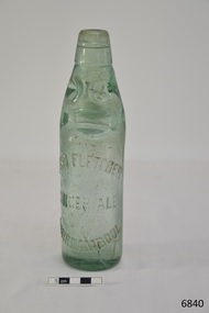
Container - Bottle, c. 1905
This bottle once contained John Fletcher’s ginger cordial. It was found in August 2014 in the sand dunes at Levy's Point, near McKinnon's quarry, Warrnambool. ABOUT JOHN FLETCHER of WARRNAMBOOL John Fletcher Cordial (or Beverage) Co . Warrnambool, supplied cordial and aerated drinks to the Western district of Victoria. John Fletcher was named as a cordial manufacturer in the Warrnambool Standard of June 13th 1895, when he attended a Publican’s Association meeting. Mr John Fletcher, aerated water and cordial manufacturer of Koroit Street Warrnambool, had a summary of his factory printed in a short article in the Advocate, Melbourne, in February 1901. The article said “one of the most complete plants outside the metropolis … spacious … well appointed …old-established business … noted for the excellence of the quality … a trial [of the beverage] is solicited.” John Fletcher and Harold Caffin, trading as J.S. Rowley & co cordial manufacturers in 1903; were prosecuted in September 1903 when the Board of Health found an analysed sample of Raspberry Vinegar to contain coal tar colouring, which could be injurious to health, particularly to the kidneys. The factory was still in operation in December 1924, when sadly, Mr S. Fletcher, who was carrying bottles of aerated water at Mr John Fletcher’s cordial factory, sustained an eye injury when one of the bottles burst. Later the eye had to be removed at the Warrnambool Base Hospital. ABOUT CODD BOTTLES During the mid-to-late 1800s there were many inventions to keep the fizz in carbonated drinks such as ginger ale, soda water and fruit drinks. Hiram Codd, an English engineer invented a successful process that he patented as “Codd’s patented globe stopper bottle” in 1872. The Codd-neck bottle (commonly called Codd or marble bottle) is manufactured in two parts. The body of the bottle is cast in two sections. At the time of joining the sections a glass marble and rubber seal are inserted into the neck section. The lip is then applied to the top of the bottle. The Codd bottle is filled upside down as the pressure of the gas from the carbonated liquid holds the marble up and out of the way. When the bottle stands upright the gas pushes the marble up against the washer, creating a firm seal to keep the fizz inside. The bottle is opened by pushing the marble down firmly to allow some of the gas to escape. The marble drops down and is caught in a depression formed in the neck. When the bottle is tilted to pour or drink the liquid the marble rests in a dimple. Some have said that the bottle as a character, the shape having a face with its mouth keeping the marble out of the drink and eyes that catch the marble so that it doesn’t roll into the mouth of the drinker. The Codd bottle was expensive to produce and children loved to destroy the marbles to play with the marbles inside. Many shops and factories added a deposit to the cost of buying the drink to encourage children to return the bottles rather than break it for the marble. Codd bottles are still being produced in India and Japan for soft drinks. A Codd bottle with the same markings as this one is valued on today’s Australian auction sites from $35 - $75 AUD. Bottle, aqua/green glass, with glass marble inside. John Fletcher's Ginger Ale, Warrnambool. Container is often called a "Codd neck bottle", “marble bottle” or “Codd’s patent bottle”. Bottle made by Dobson. Inscription on bottle and base. c. 1905Marks moulded into glass; "JOHN FLETCHER / GINGER ALE / WARRNAMBOOL" and “DOBSON” and on base “G”. flagstaff hill, warrnambool, shipwrecked coast, flagstaff hill maritime museum, maritime museum, shipwreck coast, flagstaff hill maritime village, great ocean road, codd bottle, codd neck bottle, marble bottle, ginger beer bottle, john fletcher soft drinks, warrnambool soft drinks and cordials, john fletcher cordial (or beverage) co ., codd neck bottle, glass stopper bottle, hiram codd, antique bottle, harold caffin, john fletcher -
 Kiewa Valley Historical Society
Photograph Clover Dam, Clover Dam Circa 1940, circa 1940s to 1950s
As part of the push to cut electricity costs and diversify supply, the Victorian Government (circa 1930) implemented the conversion strategy from mainly brown coal supply to hydro - electricity. The Kiewa Hydroelectric Scheme became the largest scheme of its kind in the State Of Victoria and the second largest scheme in Australia. This dam was constructed to supply water to feed four turbines (62 mega watts) at the West Kiewa Power Station. This was at the forefront of sustainable "Green" energy. Costs associated with power supplies is still a major incentive of governments, however environmentally friendly alternatives such as wind and nuclear have also made inroads. The Kiewa valley and its surrounding alpine catchment were looked at(Victorian State Government), from the beginning of the twentieth century as a source of alternate power for an every increasing demand for electricity by growing population and heavy industrial ares within Melbourne City and State regions. Construction of dams, such as Clover Dam provided the large quantity holding areas of water required to turn the turbines at the various power stations to provide the electricity needed. The impact of these controls by moderating water run off from the alpine regions is beneficial in reducing flooding from thawing of snow on the alps. This by-product allows agriculture and grazing to be less vulnerable to seasonal flooding thereby resulting in a more stable annual production level.Reproduction (scanned) of a black and white photo of Clover Dam circa 1940. The paper used is KodakXtraLife II paperThe reverse side of photo " KodakXtraLife II paperdams, pondage, hydro electricity, power stations, clover dam, secv -
 Kiewa Valley Historical Society
Evacuation Plans for children during WWII, 1941
During World War 2 the State Emergency Council for Civil Defence (Victoria) sent out forms to Municipal Councils requesting a survey to be carried out regarding the suitability of householders to accommodate persons, especially children, in the more dangerous parts of Victoria. Also, surveying parents as to their wishes regarding the evacuation of their own children if necessary. The documents list householders living in the Kiewa Valley including Gundowring giving an insight into the families (size, age, religion, sex), the homes (size, number and type of rooms), Water supply, Conveyance (motor or horse drawn), distance from railway station and school. Papers created by the State Emergency Council for Civil Defence, Premier's Department 1941 requesting Municipal Councils to survey people in case of the billeting of persons who may be evacuated from the more dangerous parts of Victoria. The Accommodation Survey lists the householder, details of the house, how many people living there and how many could be accommodated.There are also forms asking householders if they wish their children to be evacuated if necessary.Forms filled out in ink. world war ii; evacuation plans; kiewa valley; gundowring -
 Kiewa Valley Historical Society
Photograph - Kiewa River in flood at Clover Dam
As part of the push to cut electricity costs and diversify supply, the Victorian Government (circa 1930) implemented the conversion strategy from mainly brown coal supply to hydro - electricity. The Kiewa Hydroelectric Scheme became the largest scheme of its kind in the State Of Victoria and the second largest scheme in Australia. Clover Dam and Power Station were built by the State Electricity Commission of Victoria as part of the Kiewa Hydro Electric Scheme from the late 1930's to the early 1940's. This dam was constructed to supply water to feed four turbines (62 mega watts) at the West Kiewa Power Station. This was at the forefront of sustainable "Green" energy. Costs associated with power supplies is still a major incentive of governments, however environmentally friendly alternatives such as wind and nuclear have also made inroads. The Kiewa valley and its surrounding alpine catchment were looked at(Victorian State Government), from the beginning of the twentieth century as a source of alternate power for an ever-increasing demand for electricity by growing population and heavy industrial areas within Melbourne City and State regions. Construction of dams, such as Clover Dam provided the large quantity holding areas of water required to turn the turbines at the various power stations to provide the electricity needed. The impact of these controls by moderating water run-off from the alpine regions is beneficial in reducing flooding from thawing of snow on the alps. This by-product allows agriculture and grazing to be less vulnerable to seasonal flooding thereby resulting in a more stable annual production level.Black and white photograph of Clover Dam with Kiewa River in flood. .5mm white boarder on 3 sides of photo.Handwritten on back of photograph in black pen - Kiewa in flood. Clover Dam.clover dam, secv -
 Kiewa Valley Historical Society
Photograph - Clover Dam
As part of the push to cut electricity costs and diversify supply, the Victorian Government (circa 1930) implemented the conversion strategy from mainly brown coal supply to hydro - electricity. The Kiewa Hydroelectric Scheme became the largest scheme of its kind in the State Of Victoria and the second largest scheme in Australia. Clover Dam and Power Station were built by the State Electricity Commission of Victoria as part of the Kiewa Hydro Electric Scheme from the late 1930's to the early 1940's. This dam was constructed to supply water to feed four turbines (62 mega watts) at the West Kiewa Power Station. This was at the forefront of sustainable "Green" energy. Costs associated with power supplies is still a major incentive of governments, however environmentally friendly alternatives such as wind and nuclear have also made inroads. The Kiewa valley and its surrounding alpine catchment were looked at(Victorian State Government), from the beginning of the twentieth century as a source of alternate power for an ever-increasing demand for electricity by growing population and heavy industrial areas within Melbourne City and State regions. Construction of dams, such as Clover Dam provided the large quantity holding areas of water required to turn the turbines at the various power stations to provide the electricity needed. The impact of these controls by moderating water run-off from the alpine regions is beneficial in reducing flooding from thawing of snow on the alps. This by-product allows agriculture and grazing to be less vulnerable to seasonal flooding thereby resulting in a more stable annual production level.Black and white photograph of Clover Dam buildings and Kiewa River. Has a .4cm white border around photograph Printed on bottom left corner of photograph in white - Clover Flatclover dam, secv -
 Kiewa Valley Historical Society
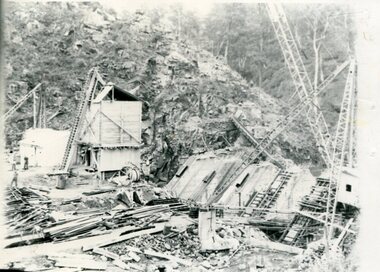
Photographs x 2 - Clover Dam, Circa 1940's
As part of the push to cut electricity costs and diversify supply, the Victorian Government (circa 1930) implemented the conversion strategy from mainly brown coal supply to hydro - electricity. The Kiewa Hydroelectric Scheme became the largest scheme of its kind in the State Of Victoria and the second largest scheme in Australia. Clover Dam and Power Station were built by the State Electricity Commission of Victoria as part of the Kiewa Hydro Electric Scheme from the late 1930's to the early 1940's. This dam was constructed to supply water to feed four turbines (62 mega watts) at the West Kiewa Power Station. This was at the forefront of sustainable "Green" energy. Costs associated with power supplies is still a major incentive of governments, however environmentally friendly alternatives such as wind and nuclear have also made inroads. The Kiewa valley and its surrounding alpine catchment were looked at(Victorian State Government), from the beginning of the twentieth century as a source of alternate power for an ever-increasing demand for electricity by growing population and heavy industrial areas within Melbourne City and State regions. Construction of dams, such as Clover Dam provided the large quantity holding areas of water required to turn the turbines at the various power stations to provide the electricity needed. The impact of these controls by moderating water run-off from the alpine regions is beneficial in reducing flooding from thawing of snow on the alps. This by-product allows agriculture and grazing to be less vulnerable to seasonal flooding thereby resulting in a more stable annual production level. Photographs also document early engineering and building techniques used in the construction of dams and power stations during the 1940’s and 1950’s. Note the lack of safety equipment and suitable work attire worn by construction workers on the sites 1. Black and white photograph of Clover Dam under construction. Has a .5cm white border around photo 2. Black and white photograph of Clover Dam under construction showing workmen at work. Has a .5cm white border around photo Written in pencil on back of both photographs - Clover Damclover dam, secv -
 Kiewa Valley Historical Society
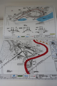
Plans - Southern Hydro - Bogong Power Development
Southern Hydro owned the Kiewa Hydro Electric Scheme in May 2006 when these plans were created. The Site No. 1 and Site No. 2 are part of the Bogong Power Development Bogong Power Development is part of the Kiewa Hydro Electric SchemeLaminated A3 plans mostly black and white but with a little color and surrounded by a grid.(Also see KVHS 1439) 1. Tunnel and Civil works / Commissioners Lodge Site Plan 1: Site No. 1 / TBN /Water /Supply / Reservoir Site 2. Tunnel and Civil Works / Pedestrian Diversion Access Paths / and Tracks: Site No. 2 / Lake Guy Site / Bogong Victoriabogong power development, southern hydro 2006 -
 The Beechworth Burke Museum
Photograph, c.1870
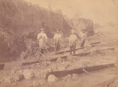
This photograph was taken in approximately 1870 and depicts four male miners standing in mining sluice at the Three Mile Goldfields. These men are wearing typical attire for 1870s gold miners. They wear white shirts, tan coloured pants with water proof shoes and most of the men are wearing an apron to prevent their clothing from becoming too dirty from the mud. Each man is wearing a wide brim hat and hold large wooden tools used for sorting through the sluice. Three of the four men have full beards. The photograph was donated to the Burke Museum by R. Ziegenbein before 2001 but the photographer and the individuals captured in the photo are unknown. The image depicts the landscape of the Three Mile Goldfields during a period when open cut sluicing was undertaken to reach gold. Open cut sluicing is a method used to extract gold and other precious metals from beneath the surface of the earth. This technique involved the use of high-powered hoses which broke down the soil enabling miners to come along and search this soil for gold. After the gold rush of the early 1850s, diggers had to enlist the assistance of heavy machinery and techniques like hydraulic sluicing in order to reach gold because the surface alluvial gold had already been discovered and removed. This heavy machinery was not used until after 1853. The Three Mile Goldfields was a site of rich alluvial gold deposits located about 5 km south of Beechworth in Victoria. Today, the location of this gold deposit is called Baarmutha. It was a popular area for gold mining in the 1850s but became largely abandoned by the following decade. In 1865, a man named John Pund recognized that the area could be potentially rich if a better water supply could be obtained. He secured a 15 year license with three other miners. Within the next five years, these men had constructed 19 km of water race going from Upper Nine Mile Creek to Three Mile Creek. By 1881, these four men had delivered 950,000 gallons to the Three Mile Sluicing area which is depicted in this photograph. Pund was later go into partnership with John Alston Wallace who would become owner of the Star Hotel in Beechworth. The Three Mile sluicing location continued to be operational until 1950. Sluice box workers were a vital part of gold mining regardless of how inefficient they were in the recovery of gold. After using hydraulic sluicing to cut away the earth, miners would use the big wooden boxes depicted in the image to catch the earth which would then be sifted for gold. However, accidents would occur often which would result in the gold washing away and unable to be recovered. It was not a very efficient system because the gold, which was alluvial and thus very fine, would often pass through the sluice box undetected.The search for gold is ingrained into the history of Victoria and therefore, images like this one which portray an open cut sluicing site can reveal important information for society and technology for the date when the photograph was taken. This image is of important historical significance for its ability to convey information about sluicing and the methods used to find gold in the late 1800s and early 1900s. It also shows a location where sluicing was undertook which provides insight into the impact of sluicing on the environment at a time when it was done. Images, like this one, of Australian gold rush history can reveal important information about the social and environmental impact of this period. This image depicts diggers standing in a mining location and therefore, this image has the capacity to reveal or support significant information for researchers studying the fashion and social status of diggers in Australia in approximately 1870. It can also provide information on the landscape of Australia in this period and the impact of mining for gold on both society and the Australian landscape. The Burke Museum is home to a substantial collection of Australian mining photographs which can be used to gain a deeper understanding into life on the gold fields, technology used in mining, the miners themselves and the impact of the gold digging on the environment.Sepia toned rectangular photograph printed on matte photographic paper and mounted on board.[illegible] about 1870 / 97 2514.1 / 2594 30three mile goldfields, goldfields, 1870, 1870 gold, australia, australian landscape, miners, gold miners, diggers, gold diggers, beechworth, victoria, sluice box workers, sluicing, sluice, mining -
 The Beechworth Burke Museum
Photograph - Photograph - Reproduction, W. D. Gibbon, Early 1900s
This photograph was taken in 1911 at Three Mile Creek, about five kilometers south of Beechworth town. Significant digging took place at this location from late 1855, which led to a flood of workers and stores to follow, though daily earnings were slim compared to the nearby Woolshed site. This remained the case even after workers at Three Mile Creek attempted to protest around Beechworth during an election in November 1855. Three Mile Creek was one of seven significant divisions of the Beechworth Mining District formalised by the Governor-in-Council in 1858, though by the time this photograph was taken, the boundaries of the original seven districts had shifted to create seventeen divisions. The Three Mile Goldfields was a site of rich alluvial gold deposits located about 5km south of Beechworth in Victoria. Today, the location of this gold deposit is called Baarmutha. It was a popular area for gold mining in the 1850s but became largely abandoned by the following decade. In 1865, a man named John Pund (a man second from the left in the back row of this photograph shares this surname) recognized that the area could be potentially rich if a better water supply could be obtained. He secured a 15 year license with three other miners. Within the next five years, these men had constructed 19 km of water race going from Upper Nine Mile Creek to Three Mile Creek. By 1881, these four men had delivered 950,000 gallons to the Three Mile Sluicing area which is depicted in this photograph. Pund would later go into partnership with John Alston Wallace who would become owner of the Star Hotel in Beechworth. The Three Mile sluicing location continued to be operational until 1950. The eleven miners in this photograph are: Back row: Led Guthrie, P. Pund, F. Beel, [Unknown] Miller Front row: Paddy McNamara, J. King, W. Beel, [Unknown] Garland, J. Clarke, J. Ryan, H. Bartsh In the background of the photograph is a huge dirt wall that appears to suffer damage caused by hydraulic sluicing. Hydraulic sluicing is a specialised mining technique that involves directing high pressure water flows at dirt to uncover gold. The technique played a significant role in shaping Beechworth's landscape during the gold rush to create the topography seen today.The search for gold is ingrained into the history of Victoria and therefore, images like this one which portray an open cut sluicing site can reveal important information for society and technology for the date when the photograph was taken. This image is of important historical significance for its ability to convey information about sluicing and the methods used to find gold in the late 1800s and early 1900s. It also shows a location where sluicing was undertook which provides insight into the impact of sluicing on the environment at a time when it was done. Images, like this one, of Australian gold rush history can reveal important information about the social and environmental impact of this period. This image depicts diggers standing in a mining location and therefore, this image has the capacity to reveal or support significant information for researchers studying the fashion and social status of diggers in Australia in approximately 1911. It can also provide information on the landscape of Australia in this period and the impact of mining for gold on both society and the Australian landscape. The Burke Museum is home to a substantial collection of Australian mining photographs which can be used to gain a deeper understanding into life on the gold fields, technology used in mining, the miners themselves and the impact of the gold digging on the environment.Black and white / sepia rectangular reproduced photograph printed on glossy photographic paper mounted on board.beechworth, beechworth museum, mining, mining team, three mile creek, sluicing, hydraulic sluicing, photography, gold sluicing, gold mining, pund mining -
 The Beechworth Burke Museum
Photograph, c1900
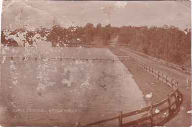
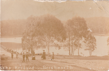
This photograph is of Lake Kerferd in the early 1900s. Both the spillway for the lake and the jetty can be seen. There is also a road that wraps around the lake and eventually disappears into the trees. This photograph is significant because it shows Lake Kerferd at the beginning of the twentieth century. The lake itself is significant because it was Beechworth's main source of water. This made it very important to the community.Black and white rectangular photograph printed on paperLake Kerferd, Beechworth / spillway, lake, dam, lake kerferd, kerferd, road, photograph, trees, gum tree, jetty, wooden fence, gravel road, australia, victoria, beechworth, 1900s beechworth, waterworks, water, water supply -
 The Beechworth Burke Museum
Photograph - Postcard, c1900
This is a photograph of Lake Kerferd in Beechworth taken in the late nineteenth or early twentieth centuries. It depicts two women, two young boys and four young girls standing in front of the lake. The women seem to be either the mothers or caregivers of the children. This photograph is significant because it depicts a group of people enjoying a outing at Lake Kerferd. This demonstrates that Lake Kerferd was a place of enjoyment for the people that lived in Beechworth during this time period. Lake Kerferd itself was also Beechworth's main water supply. This makes it very important to the community who lived there. Sepia rectangular postcard printed on paperObverse: Lake Kerferd Beechworth / wade / Reverse: Postcard / 5568 / This space may be used for correspondence / (For Address Only) /children, lake kerferd, lake, sepia photograph, photograph, beechworth, mothers, young girls, young boy, trees, caregivers, victoria, outing -
 The Beechworth Burke Museum
Photograph - Photographs, c1900
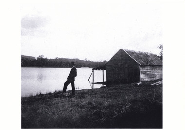
Both of these stereoscopic images depict a man standing by Lake Kerferd in Beechworth. The boathouse is located behind him. Lake Kerferd is significant because it was created in 1862 and Beechworth's main water supply. These images depict how Lake Kerferd was once used for boats because of the boathouse shown in the background of the image. However this boathouse appears to be in poor condition. This could give an indication that either boating was not a popular activity or that this boathouse in particular was not well looked after. Black and white photograph mounted on cardA03074.2 obverse: Lake Kerferd/ Beechworth/boathouse, lake, lake kerferd, man, stereoscopic, beechworth lake, beechworth, victoria, trees, boat, wooden house -
 The Beechworth Burke Museum
Photograph - Postcard, c1900
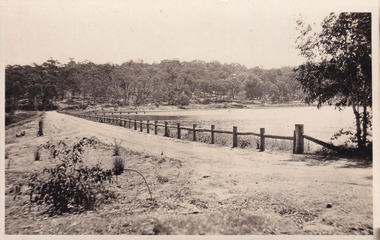
The construction on Lake Kerferd began in 1862 however it wasn't completed until 1874 due to engineering and funding issues. The lake was named after George Briscoe Kerferd (1831–1889) who was responsible for Beechworth's water scheme. George Briscoe Kerferd was born on 21 January 1831 in Liverpool, England and arrived in Melbourne April 1853. He spent his first years in Australia in Bendigo before settling down in Beechworth as a wine and spirits merchant. He married Ann Martindale on 17th December 1853 at St James Cathedral, Melbourne and between them they had three sons and five daughters. Kerferd began his political and legal career in Beechworth when he was first elected to the Municipal Council in May 1857. Later he would be elected to the Legislative Assembly for the Ovens District in November 1864, and continued to represent the area until February 1886. This photograph is historically significant as it provides insight into the water reserves of Victoria. It also demonstrates the political identity of George Briscoe Kerferd and the Beechworth Municipal Council.Sepia rectangular postcard printed on paperObverse: Reverse: 83-131-1/ Post Card/ Correspondence / Address Only / BMM2997 / 53 / [Kodak Australia Stamp] lake kerferd, beechworth, water scheme, water reserve, reservoir, legislative assembly, hon. george briscoe kerferd, catchments, beechworth water reserve, beechworth catchments, municipal council, st. james cathedral, lakes, reserve, water supply, political projects -
 The Beechworth Burke Museum
Photograph, Christmas 1941
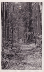
Taken on Christmas of 1941, shown is a track to Lake Kerferd with forest on both sides. The construction on Lake Kerferd began in 1862 however it wasn't completed until 1874 due to engineering and funding issues. The lake was named after George Briscoe Kerferd (1831–1889) who was responsible for Beechworth's water scheme. George Briscoe Kerferd was born on 21 January 1831 in Liverpool, England and arrived in Melbourne April 1853. He spent his first years in Australia in Bendigo before settling down in Beechworth as a wine and spirits merchant. He married Ann Martindale on 17th December 1853 at St James Cathedral, Melbourne and between them they had three sons and five daughters. Kerferd began his political and legal career in Beechworth when he was first elected to the Municipal Council in May 1857. Later he would be elected to the Legislative Assembly for the Ovens District in November 1864, and continued to represent the area until February 1886.This photograph is historically significant as it provides insight into surrounding areas of the water reserves of Victoria. It is also linked to political identity of George Briscoe Kerferd and the Beechworth Municipal Council.Black and white rectangular photograph printed on matte photographic paper.Obverse: Reverse: 8163/ Back track to Lake Kerford/ Beechworth/ Xmas 1941lake kerferd, beechworth, water scheme, water reserve, forest track, forest pathway, reservoir, legislative assembly, hon. george briscoe kerferd, catchments, beechworth water reserve, beechworth catchments, municipal council, st. james cathedral, lakes, reserve, water supply, political projects -
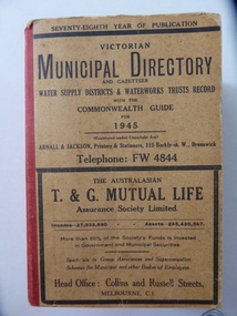 Warrnambool and District Historical Society Inc.
Stamp, W'bool Co.op Commons Seal, 1945
This is a Victorian Municipal Directory for 1945, containing general information on all municipalities in Victoria, a Gazeteer, a Commonwealth Guide and a Water Supply Record. Municipal Directories were published annually in Victoria from 1867 on. This directory came from the Shire of Mortlake which was established in 1864 when it had an area of 2137 square kilometres. The Shire of Mortlake was abolished in 1994 and merged with other neighbouring shires to form the present day Shire of Moyne. This book is very useful to researchers as it contains much information on the City, Borough and Shire structures, the Council employees and Government employees of all the municipalities. It has, therefore, important local information on Warrnambool and the surrounding areas in 1945. This is a soft cover book of 1114 pages. It has a buff- coloured cover with red binding on the spine. The printed material on the covers is printed in black. It has a blue stamp of the Shire of Mortlake on several pages. The book contains several advertisements for Melbourne businesses. ‘Shire of Mortlake’ shire of mortlake, local government in victoria, warrnambool history -
 Warrnambool and District Historical Society Inc.
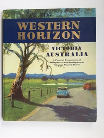
Book, Western Horizon, C 1960
This book presents a pictorial history of the western District of Victoria. It explores various aspects of the Western District such as water supply,architecture,ports,produce,and agriculture. It also presents the various scenic spots around the district. The publishers of this book , the Australian publicity Council is dedicated to publicising the state of Victoria and its natural resources in an effort to attract overseas investment and industry.This book provides a snapshot of the Western District in the 1960 's both with the information and the photographs contained within, including some which were taken by Ralph Illidge who was one on Warrnambool's best known photographers. Coloured hard board cover with country scene with road with two vehicles on a road which continues to the back cover.. A large gum tree sits beside the road. The title is gold on a navy blue banner. Thereis a small blurb on the back cover. 112 pages.Australian Publicity Council. Henry Bolte Premier of Victoria.history of warrnambool, western horizon, western victoria, ralph illidge, warrnambool 1960's