Showing 83 items matching "water catchment area"
-
 Greensborough Historical Society
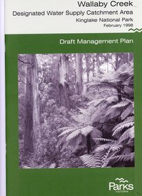
Booklet, Parks Victoria, Wallaby Creek: designated water supply catchment area. Kinglake National Park: Draft management plan 1998, 1998_02
... Wallaby Creek: designated water supply catchment area. Kinglake National Park: Draft management plan 1998...Wallaby Creek is part of Kinglake National Park, and is a restricted access catchment area to protect quality of water supplied to Melbourne's water supply system. ...Kingllake National Park water supply wallaby creek parks victoria 26 p. black print on white paper, green cover, three folded maps Wallaby Creek: designated water supply catchment area. Kinglake National Park: Draft management plan 1998 Booklet Booklet Parks Victoria Parks Victoria ...Wallaby Creek is part of Kinglake National Park, and is a restricted access catchment area to protect quality of water supplied to Melbourne's water supply system. 26 p. black print on white paper, green cover, three folded mapskingllake national park, water supply, wallaby creek, parks victoria -
 Eltham District Historical Society Inc
Film - Video (VHS), Nillumbik Shire Council, The Nillumbik Story, 1996
... ...water catchment area...CREDITS Music by John Greenfield from the CD Sweet Rain “The Snow Tree”, Uncle Music UNC 2001 Cameras - David Mirabella and Peter Farragher Editor – Olwyn Jones Written and Produced by Jason Cameron A Jason Cameron Proction for Nillumbik Shire Provides a record of the relatively newly created Shire of Nillumbik at the time and the features and attactions of the shire in its people arts, culture and environment video recording Arthurs Creek Arthurs Creek Landcare group Artists artists in residence Arts Arts Festival Authors BlackBerry Brock family Bulldozer Bulleen bushland sanctuary Caledonian gold rush Charles Reddington Clifton Pugh cottlesbridge Cypress rows developer Diamond Creek Diamond Creek Mine Diamond Reef Diamond Valley miniature railway Doncaster dunmoochin Education program EEPS Eltham Eltham East Primary School Eltham East Primary School Band Eltham Library Community Gallery Eltham Lower Park Environment fishing flour mill fruit growing fruiterer Garden Hill Gold mining Green Wedge Greensborough Heritage Trail Hurstbridge Railway Line jazz festival Jock Ryan Kangaroo Ground kangaroo ground tower Kinglake Maroondah Aqueduct Matcham Skipper Memorial Park Ming Mackay (1918-2009) Montsalvat Mudbrick houses Music musicians nesting area Nillumbik Historical Society Nillumbik Shire North Warrandyte Old timer Orchards Peter Brock Plenty River poets Population Recreation recreational activities revegetation Robert Hoddle Sandy Brock Shillinglaw Cottage Shire of Eltham War Memorial Sigmund Jorgensen St Andrews Hotel St Andrews Market Sugarloaf Reservoir Templestowe The Hill tourism Viewing platform Warrandyte water catchment area Watsons Creek Wedgetail eagle Whittlesea Wiregrass Gallery Wurundjeri Yarra River Jack Powell VHS Cassette (five copies) DVD (one copy) Converted to MP4 file format 0:22:00, 1.60GB The Nillumbik Story Film Video (VHS) Nillumbik Shire Council Jason Cameron David Mirabella Peter Farragher Olwyn Jones ...PART 1 – NILLUMBIK (00:00-07:17) Opening features various scenes around Nillumbik Shire. For 40,000 years Nillumbik was the home of the Wurundjeri people. Robert Hoddle gave the district its name. Jock Ryan, then president of Nillumbik Historical Society discusses the names Nillumbik and Diamond Creek. In the late 1830s white occupation began with gold found in Warrandyte in 1851 and 12 years later at Diamond Creek -the Diamond Reef which led to the Caledonian gold rush. Jock Ryan discusses the Diamond Creek mine, which was thriving until it burnt out in 1915. Large numbers of workmen moved into area in late 1870s to construct the Maroondah Aqueduct. With growing population of Melbourne, the nearby Yan Yean system had severely disrupted the flow of the Plenty River, forcing the closure of three flour mills there. The aqueduct came to the rescue carrying water 66km from Healesville to Preston. When the Diamond Creek gold mine burnt down the local economy suffered but fruit growing industry had already been established and Diamond Creek became a thriving fruit growing centre. Interview with Jack Powell, a long-time fruiterer at St Andrews market, his family had lived in the area for a hundred years, 3 to 4 generations, “a lot of hard work”. By the time the railway arrived fruit growing was no longer competitive. The railway brought the city closer and day trippers. The Green Wedge separates the shire from the more densely developed neighbours such as Whittlesea, Doncaster, Templestowe, Bulleen and Greensborough. Population at the time (1996) was 19,000 but links to the past remain strong. Mudbrick houses along the Heritage Trail The saving of Shillinglaw Cottage from demolition in 1963 and relocation brick by brick. PART 2 – ENVIRONMENT (07:18-14:44) Peter Brock (with Bev Brock in background) at St Andrews market discusses his childhood growing up in the district and the environment and the values it instilled upon him and his own family. The Brocks have been in the district since the 1860s. Nillumbik Shire responsible for managing three catchment areas; Diamond Creek, Arthurs Creek and Watsons Creek. Follows the course of the Diamond Creek commencing in Kinglake through the district to its confluence with the Yarra River at Eltham at Eltham Lower Park. Highlights Eltham Lower Park community revegetation program and the newly constructed (1996) viewing platform built of new and recycled timbers at the confluence of the Diamond Creek and Yarra River. Also featured are outdoor recreation on the river and at Eltham Lower Park including the Diamond Valley miniature railway. Sugarloaf reservoir and recreational activities and fishing. Aerial view of Memorial Park and Shire of Eltham War Memorial tower at Garden Hill, Kangaroo Ground. Significant tourism opportunities for the shire with 3 million potential day-trippers in metropolitan Melbourne. Council and community working together to find a way to promote the shires natural and artistic assets. At Arthurs Creek, the Brock family and neighbours working together to take care of their waterway. Peter Brock’s uncle, Sandy Brock talks about environmental management and the Arthurs Creek Landcare group and actions to eradicate blackberry problem. Having previously planted Cypress rows they are replacing them with indigenous species to improve the water supply, keeping cattle out of the creek bed to improve the quality downstream flowing into the Yarra. Eltham East Primary School Band playing “All things bright and beautiful” merges into scenes of the bushland sanctuary set aside by the school in 1980 with unidentified teacher discusses the sanctuary and their education program and school children’s comments. Plight of a family of Wedgetail eagles nesting in the path of a developer’s bulldozer at North Warrandyte and actions to save their nesting areas. PART 3 – ARTS (14:45-22:00) Arts and Jazz festival at Montsalvat featuring interviews with Sigmund Jorgensen discussing Montsalvat and its principles. Also Matcham Skipper. Clifton Pugh’s funeral at Montsalvat and his legacy at Dunmoochin near Cottlesbridge with artists in residence, at the time, Chicago artist Charles Reddington who discusses the benefits of the experience. An unidentified female artist also talks about the program and why people are drawn to the area. Unidentified man on street talking about the amount of talent in the area, artists, poets, musicians, authors. Artist Ming Mackay (1918-2009) interviewed talking about the people she mixes with on “the Hill”. Works of local artists are displayed Eltham Library Community Gallery and Wiregrass gallery with a new coffee shop at the Wiregrass making it an even more popular destination. Music at St Andrews Hotel (may be a little bit country) and the Saturday market where likely to hear anything. Sellers and patrons at the market asked about what attracts them to the market and where they came from. Scenes of poets/authors giving readings. CREDITS Music by John Greenfield from the CD Sweet Rain “The Snow Tree”, Uncle Music UNC 2001 Cameras - David Mirabella and Peter Farragher Editor – Olwyn Jones Written and Produced by Jason Cameron A Jason Cameron Proction for Nillumbik ShireProvides a record of the relatively newly created Shire of Nillumbik at the time and the features and attactions of the shire in its people arts, culture and environmentVHS Cassette (five copies) DVD (one copy) Converted to MP4 file format 0:22:00, 1.60GBvideo recording, arthurs creek, arthurs creek landcare group, artists, artists in residence, arts, arts festival, authors, blackberry, brock family, bulldozer, bulleen, bushland sanctuary, caledonian gold rush, charles reddington, clifton pugh, cottlesbridge, cypress rows, developer, diamond creek, diamond creek mine, diamond reef, diamond valley miniature railway, doncaster, dunmoochin, education program, eeps, eltham, eltham east primary school, eltham east primary school band, eltham library community gallery, eltham lower park, environment, fishing, flour mill, fruit growing, fruiterer, garden hill, gold mining, green wedge, greensborough, heritage trail, hurstbridge railway line, jazz festival, jock ryan, kangaroo ground, kangaroo ground tower, kinglake, maroondah aqueduct, matcham skipper, memorial park, ming mackay (1918-2009), montsalvat, mudbrick houses, music, musicians, nesting area, nillumbik historical society, nillumbik shire, north warrandyte, old timer, orchards, peter brock, plenty river, poets, population, recreation, recreational activities, revegetation, robert hoddle, sandy brock, shillinglaw cottage, shire of eltham war memorial, sigmund jorgensen, st andrews hotel, st andrews market, sugarloaf reservoir, templestowe, the hill, tourism, viewing platform, warrandyte, water catchment area, watsons creek, wedgetail eagle, whittlesea, wiregrass gallery, wurundjeri, yarra river, jack powell -
 Eltham District Historical Society Inc
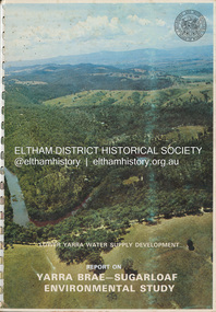
Book, Melbourne Metropolitan Board of Works, Lower Yarra Water Supply DeVelopment: Report on Yarra Brae-Sugarloaf Environmental Study, April 1974
... ...water catchment area...Eltham District Historical Society Inc 728 Main Rd Eltham melbourne Environmental Study Melbourne Metropolitan Board of Works Report Sugarloaf Reservoir water catchment area water supply Yarra Brae Dam Yarra River Valley A4 x 3cm Spiral bound 1 v. ...environmental study, melbourne metropolitan board of works, report, sugarloaf reservoir, water catchment area, water supply, yarra brae dam, yarra river valley -
 Bendigo Historical Society Inc.
Document - Kangaroo Flat Gold Mine Collection: Diamond Hill Historic Area, Department of Conservation and Environment, April 1991
... Its location is now inaccessible and within the water catchment area. Diamond Hill was reputedly named after a diamond shaped rock on the hill. ...Its location is now inaccessible and within the water catchment area. Diamond Hill was reputedly named after a diamond shaped rock on the hill. ...Diamond Hill was a gold mining village 5 km south of Bendigo and about 1 km west of the Spring Gully Reservoir. Its location is now inaccessible and within the water catchment area. Diamond Hill was reputedly named after a diamond shaped rock on the hill. With the development of mining companies which employed workers with families, a school was needed by 1873 and one was opened at the beginning of the next year. The mining companies included Great Comet Quartz Mining, Golden Fleece Quartz Mining, Albert Tribute, Glasgow Golconda, and Albert Gold Mining and Crushing. Mining continued beyond 1900, as recorded in the Australian handbook, 1903. The Bendigo Mining N.L. company was located nearby, adjoining Ham Street. One page double sided information sheet, produced by Department of Conservation and Environment, April 1991, detailing the mining history of the Diamond Hill area, Kangaroo Flat/Spring Gully area. On the back of the sheet: map of the Diamond Hill historic area, showing location of former mining sites. bendigo mining n.l., bendigo, mining, gold, city of greater bendigo, great comet quartz mining, golden fleece quartz mining, albert tribute, glasgow golconda, albert gold mining and crushing, golden gully, dead dog gully, german miners, british new chum, south golden carshalton, hansel mundy, morning light, mullock tailings, stamp battery, -
 Bendigo Historical Society Inc.
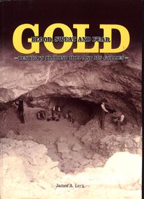
Book - "Gold. Blood, sweat and fear. Bendigo's Diamond Hill and its gullies", 2002
... Its location is now in the water catchment area. Diamond Hill was reputedly named after a diamond shaped rock on the hill. ...Its location is now in the water catchment area. Diamond Hill was reputedly named after a diamond shaped rock on the hill. ...Bendigo's Diamond Hill forms part of the southern part of Bendigo goldfields. Diamond Hill was a gold mining village 5 km south of Bendigo and about 1 km west of the Spring Gully Reservoir. Its location is now in the water catchment area. Diamond Hill was reputedly named after a diamond shaped rock on the hill. With the development of mining companies which employed workers with families, a school was needed by 1873 and one was opened at the beginning of the next year. The mining companies included Great Comet Quartz Mining, Golden Fleece Quartz Mining, Albert Tribute and Albert Gold Mining and Crushing. Mining continued beyond 1900. This book discusses history of the area from Dream Time to first European contact, focusing on the associated mining in the area. "Gold. Blood, Sweat and Fear. Bendigo's Diamond Hill and its gullies" by James A Lerk. Published in by JA and ERS Lerk. Published in 2016. Soft cover book. Front cover has sepia image of miners in mine. Back cover is black with assortment of handwritten documents/invoices. Title written in gold and dark brown. Title also on spine. Printed in Bendigo, Australia. 252 pp. Folded Bendigo map folded inside back cover. Contains both text and black and white images. Has index. gold, diamond hill, miners, mining -
 Kiewa Valley Historical Society
Photograph - Kiewa River in flood at Clover Dam
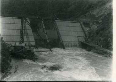
... water to feed four turbines (62 mega watts) at the West Kiewa Power Station. This was at the forefront of sustainable "Green" energy. Costs associated with power supplies is still a major incentive of governments, however environmentally friendly alternatives such as wind and nuclear have also made inroads. The Kiewa valley and its surrounding alpine catchment were looked at(Victorian State Government), from the beginning of the twentieth century as a source of alternate power for an ever-increasing demand for electricity by growing population and heavy industrial areas within Melbourne City and State regions. ...As part of the push to cut electricity costs and diversify supply, the Victorian Government (circa 1930) implemented the conversion strategy from mainly brown coal supply to hydro - electricity. The Kiewa Hydroelectric Scheme became the largest scheme of its kind in the State Of Victoria and the second largest scheme in Australia. Clover Dam and Power Station were built by the State Electricity Commission of Victoria as part of the Kiewa Hydro Electric Scheme from the late 1930's to the early 1940's. This dam was constructed to supply water to feed four turbines (62 mega watts) at the West Kiewa Power Station. This was at the forefront of sustainable "Green" energy. Costs associated with power supplies is still a major incentive of governments, however environmentally friendly alternatives such as wind and nuclear have also made inroads. The Kiewa valley and its surrounding alpine catchment were looked at(Victorian State Government), from the beginning of the twentieth century as a source of alternate power for an ever-increasing demand for electricity by growing population and heavy industrial areas within Melbourne City and State regions. Construction of dams, such as Clover Dam provided the large quantity holding areas of water required to turn the turbines at the various power stations to provide the electricity needed. The impact of these controls by moderating water run-off from the alpine regions is beneficial in reducing flooding from thawing of snow on the alps. This by-product allows agriculture and grazing to be less vulnerable to seasonal flooding thereby resulting in a more stable annual production level.Black and white photograph of Clover Dam with Kiewa River in flood. .5mm white boarder on 3 sides of photo.Handwritten on back of photograph in black pen - Kiewa in flood. Clover Dam.clover dam, secv -
 Kiewa Valley Historical Society
Photograph - Clover Dam
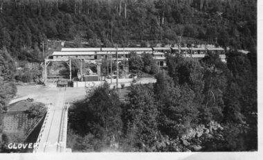
... water to feed four turbines (62 mega watts) at the West Kiewa Power Station. This was at the forefront of sustainable "Green" energy. Costs associated with power supplies is still a major incentive of governments, however environmentally friendly alternatives such as wind and nuclear have also made inroads. The Kiewa valley and its surrounding alpine catchment were looked at(Victorian State Government), from the beginning of the twentieth century as a source of alternate power for an ever-increasing demand for electricity by growing population and heavy industrial areas within Melbourne City and State regions. ...As part of the push to cut electricity costs and diversify supply, the Victorian Government (circa 1930) implemented the conversion strategy from mainly brown coal supply to hydro - electricity. The Kiewa Hydroelectric Scheme became the largest scheme of its kind in the State Of Victoria and the second largest scheme in Australia. Clover Dam and Power Station were built by the State Electricity Commission of Victoria as part of the Kiewa Hydro Electric Scheme from the late 1930's to the early 1940's. This dam was constructed to supply water to feed four turbines (62 mega watts) at the West Kiewa Power Station. This was at the forefront of sustainable "Green" energy. Costs associated with power supplies is still a major incentive of governments, however environmentally friendly alternatives such as wind and nuclear have also made inroads. The Kiewa valley and its surrounding alpine catchment were looked at(Victorian State Government), from the beginning of the twentieth century as a source of alternate power for an ever-increasing demand for electricity by growing population and heavy industrial areas within Melbourne City and State regions. Construction of dams, such as Clover Dam provided the large quantity holding areas of water required to turn the turbines at the various power stations to provide the electricity needed. The impact of these controls by moderating water run-off from the alpine regions is beneficial in reducing flooding from thawing of snow on the alps. This by-product allows agriculture and grazing to be less vulnerable to seasonal flooding thereby resulting in a more stable annual production level.Black and white photograph of Clover Dam buildings and Kiewa River. Has a .4cm white border around photograph Printed on bottom left corner of photograph in white - Clover Flatclover dam, secv -
 Kiewa Valley Historical Society
Photographs x 2 - Clover Dam, Circa 1940's
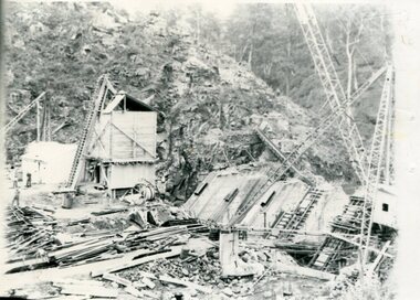
... water to feed four turbines (62 mega watts) at the West Kiewa Power Station. This was at the forefront of sustainable "Green" energy. Costs associated with power supplies is still a major incentive of governments, however environmentally friendly alternatives such as wind and nuclear have also made inroads. The Kiewa valley and its surrounding alpine catchment were looked at(Victorian State Government), from the beginning of the twentieth century as a source of alternate power for an ever-increasing demand for electricity by growing population and heavy industrial areas within Melbourne City and State regions. ...As part of the push to cut electricity costs and diversify supply, the Victorian Government (circa 1930) implemented the conversion strategy from mainly brown coal supply to hydro - electricity. The Kiewa Hydroelectric Scheme became the largest scheme of its kind in the State Of Victoria and the second largest scheme in Australia. Clover Dam and Power Station were built by the State Electricity Commission of Victoria as part of the Kiewa Hydro Electric Scheme from the late 1930's to the early 1940's. This dam was constructed to supply water to feed four turbines (62 mega watts) at the West Kiewa Power Station. This was at the forefront of sustainable "Green" energy. Costs associated with power supplies is still a major incentive of governments, however environmentally friendly alternatives such as wind and nuclear have also made inroads. The Kiewa valley and its surrounding alpine catchment were looked at(Victorian State Government), from the beginning of the twentieth century as a source of alternate power for an ever-increasing demand for electricity by growing population and heavy industrial areas within Melbourne City and State regions. Construction of dams, such as Clover Dam provided the large quantity holding areas of water required to turn the turbines at the various power stations to provide the electricity needed. The impact of these controls by moderating water run-off from the alpine regions is beneficial in reducing flooding from thawing of snow on the alps. This by-product allows agriculture and grazing to be less vulnerable to seasonal flooding thereby resulting in a more stable annual production level. Photographs also document early engineering and building techniques used in the construction of dams and power stations during the 1940’s and 1950’s. Note the lack of safety equipment and suitable work attire worn by construction workers on the sites 1. Black and white photograph of Clover Dam under construction. Has a .5cm white border around photo 2. Black and white photograph of Clover Dam under construction showing workmen at work. Has a .5cm white border around photo Written in pencil on back of both photographs - Clover Damclover dam, secv -
 Kiewa Valley Historical Society
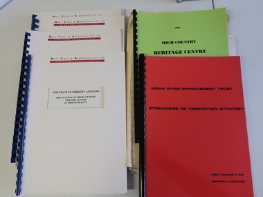
Collection of Papers and Books re - Mt Beauty Heritage Centre
... Water Supply Catchment 8. Geological Survey of Vic., Plates, Bulletin No. 44 - in battered paper 'bag' with front cover list of contents - 15 plates 9. Geological Survey - A3 photo copies of pages 106-117 10. Geological Survey of Vic. - Report of Progress No VII 1884 - bound book 11. Geological Survey of Vic. Bulletin 56 - includes nth east Vic. 1958 - bound book with green cloth spine 12. Department of Mines Report Vic. 1906 - booklet held with two staples 13. Royal Society of Vic book - The Geology of the Kiewa Area...area. Mt Beauty Heritage Centre Mt Beauty Discovery Centre Geological Surveys 1. Bogong - The Alpine Discovery Centre 2. Heritage Centre - black folder 3. Heritage Centre - manila folder 4. High Country Heritage Centre - 1991 - green spiral folder 5. Six Heritage Centre - Matt Viney & Associates - white spiral folders 6. Landscape Consultants - Susan Campbell & son - red spiral folder 7. Plant List - Upper Kiewa Valley Water Supply Catchment ...In the early 1990s the KVHS applied for a grant to create the Mt Beauty Heritage Centre / Discovery Centre. This involved employing consultants and further research.This collection includes a lot of detail of the Kiewa Valley area.1. Bogong - The Alpine Discovery Centre 2. Heritage Centre - black folder 3. Heritage Centre - manila folder 4. High Country Heritage Centre - 1991 - green spiral folder 5. Six Heritage Centre - Matt Viney & Associates - white spiral folders 6. Landscape Consultants - Susan Campbell & son - red spiral folder 7. Plant List - Upper Kiewa Valley Water Supply Catchment 8. Geological Survey of Vic., Plates, Bulletin No. 44 - in battered paper 'bag' with front cover list of contents - 15 plates 9. Geological Survey - A3 photo copies of pages 106-117 10. Geological Survey of Vic. - Report of Progress No VII 1884 - bound book 11. Geological Survey of Vic. Bulletin 56 - includes nth east Vic. 1958 - bound book with green cloth spine 12. Department of Mines Report Vic. 1906 - booklet held with two staples 13. Royal Society of Vic book - The Geology of the Kiewa Area 1961 14. Miscellaneous papers - Geological Survey, Reports of Fossil Specimens and maps of local area 15. Gold - Appendix K and Appendix 111, Part C - photocopied pages from Vic Mining Registrars Report 1888 - manila foldermt beauty heritage centre, mt beauty discovery centre, geological surveys -
 Kiewa Valley Historical Society
Ron White's Collection - 1920 - 2019
... catchment areas. He had a close association with the local communities and care for the welfare of employees. He lived in Mt Beauty and was well respected in the community and beyond. He passed away on 30 September 2019, aged 99 years. ron white hydro engineer kiewa hydro electric scheme F) One photo of Ron with 'Ken Connors'. One photo with 'l to r: Norm Middleton, Graham Napier, Ron White, Les Peart.' G) 2003 fires has a note re time, date and whereabouts of fires H) "Presented To / Ron White / In Appreciation For Service / To The / Kiewa Valley / Water ...Ron White was born in 1920. He received a Diploma of Mechanical Engineering at Footscray Technical School in 1946. He started work as a laboratory assistant and after several promotions was appointed Senior Operator in 1948. In 1949, he was Engineer, Grade 1 (Hydro Areas). After further promotions he became Assistant Area Engineer, Rubicon at new Eildon Power Station and Area Engineer, Kiewa in commissioning Mt Beauty Terminal Station and West Kiewa Power Station.. By 1956, he was the Area Operations Engineer at Kiewa and four years later the Kiewa Electrical Superintendent (Operations and Maintenance) . In 1961, he was officially recognised as deputy for the General Superintendent, Kiewa. In 1966 he was appointed General Superintendent Kiewa and Kiewa became 'a branch of the Transmission Department'. In 1974, the Rubicon / Eildon Area was also under Ron's control. His title was "Principal Hydro Engineer, Hydro Division, Transmission Operations Department. He held this position until his retirement in 1985.Ron White was an important identity in his role as Principal Hydro Engineer from 1966 to 1985 after the completion of the Kiewa Hydro Electric Scheme. His long period of service involved him in the construction, operation and maintenance of the SECV's Hydro Electric Schemes and administration of related catchment areas. He had a close association with the local communities and care for the welfare of employees. He lived in Mt Beauty and was well respected in the community and beyond. He passed away on 30 September 2019, aged 99 years.A) History of Ron White's Working Life: including papers relating to "Promotion & Staff Appointment" B) Ron White's Retirement - 11th Jan. 1985: papers, cards, letters, photos, disc/plaque C) Ron White's Certificates: Diploma of Mechanical Engineering; First Aid; D) Ron White's Correspondence - miscellaneous E) Ron White's History of the 'Kiewa Scheme' from 1936- 1966. Written 1986 F) Ron White's Photo album Includes photos of him and the 2003 bushfires G) Miscellaneous Photos (not labelled) from Ron's photo album. Possibly relatives including nieces and nephews. H) Pewter Mug presented to Ron - Water Board I) Wall hanging presented to Ron - Scouts J) Ron White's Slide Ruler & Mathematical Instruments K) Collection of 7 books owned by Ron L) Starting Pistol Caps box M) Ice-cream serverF) One photo of Ron with 'Ken Connors'. One photo with 'l to r: Norm Middleton, Graham Napier, Ron White, Les Peart.' G) 2003 fires has a note re time, date and whereabouts of fires H) "Presented To / Ron White / In Appreciation For Service / To The / Kiewa Valley / Water Authority / And / Its predecessor Bodies / December 1994 I) Wall hanging: On emblem - "Lord Baden-Powell Society / The Scout Association of Australia". On Name Plate below - Ronald K. White 1989" J) mathematical Instruments have 'R. W' embossed in red on the corner of the cover M) 100 Straitline, Starting Pistol Caps N) National Ice-cream Server with stainless steel spring Size 20 ron white, hydro engineer, kiewa hydro electric scheme -
 Kiewa Valley Historical Society
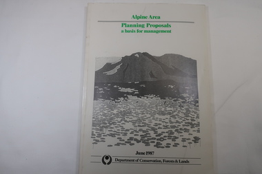
Book - Book - Alpine Area - Department of Conservation, Forests & Lands, Alpine Area / Planning Proposals / a basis for management. 1987
... areas. It is noted for its diverse plant and animal life, scenery, recreation opportunities and as a water catchment. ...It is the policy of the Government that most of the State's alpine area will be proclaimed as an Alpine National Park, which would complement the Kosciusko National Park in N.S.W.. This is yet to be achieved (1987), however there is a need for sound, efficient and coordinated management based on the area's natural features, values and uses. Planning is proceeding on this basis.Victoria's alpine area is one of the State's most outstanding and spectacular natural areas. It is noted for its diverse plant and animal life, scenery, recreation opportunities and as a water catchment. This country is at the upper end of the Kiewa Valley and the planning for it is of interest to the Kiewa Valley inhabitants.White bound book with green print for title at the top, black & white picture and black print at the bottom for the name of the government authority publishing the book.143 pages with fold out map after page 7. The map is coloured green to indicate the planning area.alpine area, bogong national park, victorian department of conservation forests & lands -
 Kiewa Valley Historical Society
Photograph Clover Dam, Clover Dam Circa 1940, circa 1940s to 1950s
... The Kiewa valley and its surrounding alpine catchment were looked at(Victorian State Government), from the beginning of the twentieth century as a source of alternate power for an every increasing demand for electricity by growing population and heavy industrial ares within Melbourne City and State regions. Construction of dams, such as Clover Dam provided the large quantity holding areas of water ...As part of the push to cut electricity costs and diversify supply, the Victorian Government (circa 1930) implemented the conversion strategy from mainly brown coal supply to hydro - electricity. The Kiewa Hydroelectric Scheme became the largest scheme of its kind in the State Of Victoria and the second largest scheme in Australia. This dam was constructed to supply water to feed four turbines (62 mega watts) at the West Kiewa Power Station. This was at the forefront of sustainable "Green" energy. Costs associated with power supplies is still a major incentive of governments, however environmentally friendly alternatives such as wind and nuclear have also made inroads. The Kiewa valley and its surrounding alpine catchment were looked at(Victorian State Government), from the beginning of the twentieth century as a source of alternate power for an every increasing demand for electricity by growing population and heavy industrial ares within Melbourne City and State regions. Construction of dams, such as Clover Dam provided the large quantity holding areas of water required to turn the turbines at the various power stations to provide the electricity needed. The impact of these controls by moderating water run off from the alpine regions is beneficial in reducing flooding from thawing of snow on the alps. This by-product allows agriculture and grazing to be less vulnerable to seasonal flooding thereby resulting in a more stable annual production level.Reproduction (scanned) of a black and white photo of Clover Dam circa 1940. The paper used is KodakXtraLife II paperThe reverse side of photo " KodakXtraLife II paperdams, pondage, hydro electricity, power stations, clover dam, secv -
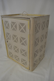 Kiewa Valley Historical Society
Safe Coolgardie, circa early 1900s
... catch water spills. When in use the "box" is covered with a water "soaked" cloth. The wet cloth is used as "coolant" ie. fibers in the cloth hold the water droplets seep out evaporating the area and thereby (in mass) cooling the air inside the container....catch water spills. When in use the "box" is covered with a water "soaked" cloth. The wet cloth is used as "coolant" ie. fibers in the cloth hold the water droplets seep out evaporating the area and thereby (in mass) cooling the air inside the container. ...The harsh summer temperatures and the isolated rural environment(of the 1890's) provided the inventor of the "Coolgardie safe" (Arthur Patrick McCormick) with an idea to cool perishable foods by using water soaked "hessian" cloth to provide the "coolant" for the evaporation process to cool the inside temperature of the "safe". Items such as meat,cream/milk/butter and cool "drinks" are a few perishables that need cool environments , especially in isolated "ice free" locations. Cities during this time period had large "ice works" which delivered block ice to all areas that required a form of refrigeration. These ice blocks where held in early refrigerators to keep perishables cool to cold. This "Coolardie" safe was the next best thing for isolated rural households and travellers/campers/stockmen to provide a cooler environment for foodstuff affected by heat. Ice filled "esky" coolers and ice boxes are a modern day off shoot to the original Coogardie safe however they still rely on ice or frozen coolant bricks for cooling.This "Coogardie" safe is very significant to the Kiewa Valley and the Bogong High Plains because it represents not only the initiative thinking of the early settlers and communities but also the "primitive" solution to an everyday (1800s to 1930s) problem (before gas and electric run refrigerators) of keeping "perishables" at a low temperature and thereby prolonging their "shelf" life. This was before electricity and gas was available to the inhabitants of the Kiewa Valley and Bogong High Plains. Another cooling method for food was to have "water tight" containers dipped into the very cold streams running from the "cooler" alpine mountains and the Bogong High Plains. This however could not be carried out in all situations eg. fast flowing currents and locations away from streams. This "Coolgardie safe" is made from a medium grade steel enclosure and its appearance is of a perforated box with a wire handle and one side (long side) being a hinged "door" with a clasp securing "lock". There are air holes grouped into a small "boxed" pattern. Each "box" is divided by a crossed pattern, dividing the "holed" sections(4) into a diamond configuration of 49 small holes each. There are four sides (long) which have the perforations except for the base which does not. The base has an indentation with a loose "catch" tray to catch water spills. When in use the "box" is covered with a water "soaked" cloth. The wet cloth is used as "coolant" ie. fibers in the cloth hold the water droplets seep out evaporating the area and thereby (in mass) cooling the air inside the container.domestic refrigeration cabinets, coolgardie "safe", insect and vermin proof food containers, electric and gas free cold storage containers -
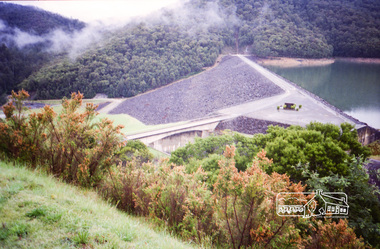
 Eltham District Historical Society Inc
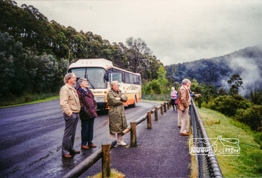
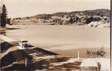
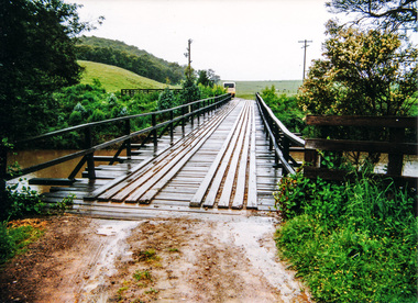
Photograph, Upper Yarra Dam, Spring Tour, 22 Oct 1995, 22/10/1995
... catchment area). Finished in 1957 after ten years work and 100 years after Yan Yean, it supplies much of Melbourne's water. ...catchment area). Finished in 1957 after ten years work and 100 years after Yan Yean, it supplies much of Melbourne's water. ...EXPLORING THE UPPER YARRA (Newsletter No. 105, November 1995, by Bettina Woodburn) We enjoyed the Spring Excursion, this year "Exploring the Upper Yarra" - in spite of the constant rain and the countryside under the cloud cover, especially in the valleys, being mainly shiny shades of green. The occasional fields of buttercups, clumps of arum lilies and splendid rhododendron and other flowering bushes became very special. The Cobb and Co coach was warm and a cosy retreat as we zig-zagged on the highways and byways to glimpse the Yarra River, upstream and down, its secret places, and particularly the many bridges. Russell excelled as 'Poet Laureate', reading from Dacre Smyth's book. This 1979 publication includes paintings of all the bridges along the river with poems and brief descriptions of each one. Some of the bridges are in out of the way places and are not very well known. We looked forward to hearing the poetry as much as seeing the ' constructions'…Big Pat (was he short or tall, lean or fat? He did win the two hundred pound reward for discovering gold and had the creek named after him), about the 'Eddies'?, and the disliked 'meccano' bridge in Warburton, etc. etc. The hot roast lunch in the old Reefton Hotel was also most welcome. It was easy to imagine it peopled by miners and early settlers. Starting by crossing the new (1974) concrete bridge at Warrandyte we headed through Wonga Park with views to the Christmas Hills and to the escarpment of the Yering Gorge, which causes flood waters to back up through the Yarra Glen plain, so avoiding disasters downstream. At the end of a long driveway we found the wooden, privately owned Henley Bridge (1935 after the 1934 floods). This facilitates access to different parts of Henley Farm and to Lilydale. Everard Park, named after Blanche Shallard's father, a State Member for 17 years, below the Highway Yarra crossing was in need of care. It is 10 miles from Yarra Glen by road but, as "Yarra Marra” canoeists well know, 32 winding miles down by water. After more delightful countryside scenes we joined the Warburton Highway at Woori Yallock. From the old Railway Station at Launching Place the Centennial Trail for walkers, cyclists and ' horse riders has replaced the rails. The line from Lilydale was opened in 1901, and the last diesel freight train ran to Warburton in 1965. It continued to rain as we had morning tea in Warburton in a shelter between footbridges. From here we continued upstream past the Bridge to O'Shannasy Lodge and Reservoir, Starvation Creek, and the Peninsular tunnel (miners dug it as at Pound Bend) which we visited (scrambling down those steps!) on our return after lunch. Our furthermost point was the Upper Yarra Dam Reserve (and vast catchment area). Finished in 1957 after ten years work and 100 years after Yan Yean, it supplies much of Melbourne's water. After crossing the 30m Launching Place Bridge to the Eltham side of the Yarra and Healesville, we saw in the distance the Yarra Glen Timber Trestle Bridge over the river flats "the longest for years in the land it was said!" Harry's dream of "better weather over the Divide" unfortunately didn't come true, but I'm sure we 36 members will retain happy memories of a day that was wet and green and filled with Bridges. Bettina Woodburn - October 1995 Record of the Society's history of activities - Spring 1995 excursionColour photographshire of eltham historical society, activities, upper yarra dam, henley bridge -
 Eltham District Historical Society Inc
Photograph - Digital Photograph, Alan King, Maroondah Aqueduct Siphon Bridge over the Plenty River, 26 January 2008
... water supply, it also had a huge impact on communities, which mushroomed along its route. Named after the Aboriginal word for the area around the Maroondah Reservoir, the Maroondah Aqueduct was fully operational until the 1970s. Since the 1980s the land along parts of the aqueduct have been used for walking and bicycle riding, shaded in places by Monterey Pine trees planted to stabilise the surrounding ground. From 1857 the Yan Yean Reservoir supplied Melbourne’s water but the growing city needed additional catchments...water supply, it also had a huge impact on communities, which mushroomed along its route. Named after the Aboriginal word for the area around the Maroondah Reservoir, the Maroondah Aqueduct was fully operational until the 1970s. Since the 1980s the land along parts of the aqueduct have been used for walking and bicycle riding, shaded in places by Monterey Pine trees planted to stabilise the surrounding ground. From 1857 the Yan Yean Reservoir supplied Melbourne’s water but the growing city needed additional catchments ...Opened in 1891, the bridge formed part of the Maroondah Aqueduct carrying water from Watts River near Healesville to the reservoir at Preston where it joined Melbourne's metropolitan water system. Covered under Heritage Overlay, Nillumbik Planning Scheme. Published: Nillumbik Now and Then / Marguerite Marshall 2008; photographs Alan King with Marguerite Marshall.; p99 Built to supply thirsty Melbourne in the late 19th century, the siphon bridge spanning the Plenty River off Leischa Court, Greensborough, was part of an engineering masterpiece. Opened in 1891, the bridge formed part of the Maroondah Aqueduct carrying water from the Watts River near Healesville to the reservoir at Preston where it joined the metropolitan distribution system. A major link in Melbourne’s water supply, it also had a huge impact on communities, which mushroomed along its route. Named after the Aboriginal word for the area around the Maroondah Reservoir, the Maroondah Aqueduct was fully operational until the 1970s. Since the 1980s the land along parts of the aqueduct have been used for walking and bicycle riding, shaded in places by Monterey Pine trees planted to stabilise the surrounding ground. From 1857 the Yan Yean Reservoir supplied Melbourne’s water but the growing city needed additional catchments.1 In 1886 work began on a weir on the Watts River to enable the aqueduct to carry most of the river water 41 miles (66km) to Melbourne. The aqueduct, built by the Board of Works, is the oldest remaining aqueduct near Melbourne and was probably the first built with concrete.2 Although the aqueduct is now only used between the Maroondah and Sugarloaf Reservoirs, it can still be traced across the Shire. It extends from the Maroondah Reservoir through Christmas Hills, Kangaroo Ground, Research, Eltham, St Helena and then previously wound west through Greensborough to Reservoir.3 Built by horse and manpower the aqueduct gravity fed 25 million gallons (113.6ML) of water a day to Melbourne along a gradient of one foot to the mile. It included 25 miles (41km) of open concrete and brick channel, six miles (10km) of tunnels, and nine miles (15km) of 14 inverted siphons of riveted wrought-iron across creeks. Bricks for the aqueduct were made from clay found near the sites and remains of several kilns can still be found between Kangaroo Ground and Christmas Hills. Building the aqueduct transformed local communities. An abattoir was established at Christmas Hills. Grog shanties and labourers’ camps sprang up and local courts dealt with cases of ‘petty pilfering and boisterous behaviour’.4 The Kangaroo Ground school population jumped to 91, crammed into a room with one teacher. Miners who built the tunnels camped just north of Churinga in Greensborough – then called Tunnel Hill Camp – and adjacent to the Evelyn Arms Hotel. The miners’ high spirits were sometimes quenched in horse troughs or by a ‘welt under the ear and kick on the behind’ as the local constable calmed them down rather than lock them up.5 But the growing city of Melbourne needed more water, so the O’Shannassy catchment, east of Warburton, was added to the system in 1914. In 1920 work began on the present concrete Maroondah Dam one mile (1.6km) from the weir on the Watts River. The aqueduct capacity was thus doubled to 50 million gallons (227ML) a day.6 Intense land development threatened to pollute the open water supply, so channel sections were replaced with large pipes. In the late 1960s a large water main was built from the tunnel outlet at Research and extended through St Helena and Greensborough, so this section of the aqueduct was taken out of use. Long sections of the unused open channels in Greensborough and Bundoora were destroyed, but the old channel in Research and Eltham North remained largely intact. In the 1970s, the Sugarloaf Reservoir was constructed, inundating 445 hectares of land in Christmas Hills. Sugarloaf was officially opened in 1980 and serves as a water storage and treatment plant supplying Melbourne. In the early 1980s pipes replaced the section from Sugarloaf Reservoir to the tunnel entrance at Kangaroo Ground. The Research-Kangaroo Ground tunnel operates as part of the pipeline system.This collection of almost 130 photos about places and people within the Shire of Nillumbik, an urban and rural municipality in Melbourne's north, contributes to an understanding of the history of the Shire. Published in 2008 immediately prior to the Black Saturday bushfires of February 7, 2009, it documents sites that were impacted, and in some cases destroyed by the fires. It includes photographs taken especially for the publication, creating a unique time capsule representing the Shire in the early 21st century. It remains the most recent comprehenesive publication devoted to the Shire's history connecting local residents to the past. nillumbik now and then (marshall-king) collection, maroondah aqueduct, pipe bridge, siphon bridge -
 The Beechworth Burke Museum
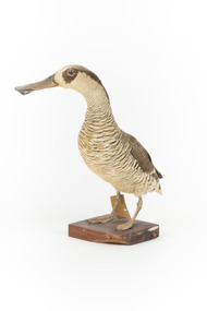
Animal specimen - Pink-Eared Duck, Trustees of the Australian Museum, 1860-1880
... water. This species of Duck prefers to reside in areas which are shallow, temporary waters and on occasion may venture into open wetlands if with a large flock; however, this species is highly dispersive and often nomadic. The special bill of this Duck is designed to enable the bird to catch...water. This species of Duck prefers to reside in areas which are shallow, temporary waters and on occasion may venture into open wetlands if with a large flock; however, this species is highly dispersive and often nomadic. The special bill of this Duck is designed to enable the bird to catch ...The Pink-eared Duck can be found throughout Australia, commonly in locations that are timbered and near water. This species of Duck prefers to reside in areas which are shallow, temporary waters and on occasion may venture into open wetlands if with a large flock; however, this species is highly dispersive and often nomadic. The special bill of this Duck is designed to enable the bird to catch their food. The bill is fringed with grooves which filter out microscopic plants and animals from the water which makes up the birds diet. This specimen is part of a collection of almost 200 animal specimens that were originally acquired as skins from various institutions across Australia, including the Australian Museum in Sydney and the National Museum of Victoria (known as Museums Victoria since 1983), as well as individuals such as amateur anthropologist Reynell Eveleigh Johns between 1860-1880. These skins were then mounted by members of the Burke Museum Committee and put-on display in the formal space of the Museum’s original exhibition hall where they continue to be on display. This display of taxidermy mounts initially served to instruct visitors to the Burke Museum of the natural world around them, today it serves as an insight into the collecting habits of the 19th century.This specimen is part of a significant and rare taxidermy mount collection in the Burke Museum. This collection is scientifically and culturally important for reminding us of how science continues to shape our understanding of the modern world. They demonstrate a capacity to hold evidence of how Australia’s fauna history existed in the past and are potentially important for future environmental research. This collection continues to be on display in the Museum and has become a key part to interpreting the collecting habits of the 19th century.The Pink-Eared Duck is named for the small pink spot of feathers which feature on the sides of the drake's head. Another name for this bird is Zebra Duck because of the striking bold black and white striped plumage which decorates the duck's neck, breast and stomach. The bill is spoon shaped and the eyes are made of dark coloured glass and surrounded by brown colouring. The bird has brown wings and light coloured legs with webbed toes. This particular specimen stands on a wooden square platform. There are signs of damage on the platform and a wooden identification tag is tied to the upper right leg of the bird.6a./ Pink-eyed Duck / See Catalogue, page 39 / taxidermy mount, taxidermy, animalia, burke museum, beechworth, australian museum, skin, reynell eveleigh johns, bird, australian birds, duck, pink-eyed duck, pink-eared duck -
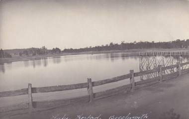 The Beechworth Burke Museum
Photograph - Post Card, 1920-1930's
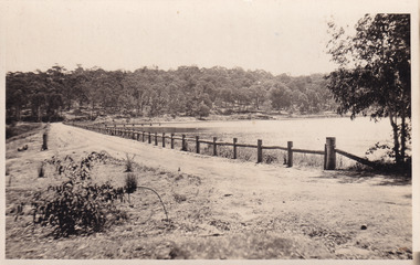
... It also presents information on the environmental development or degradation for the area, with possible changes to the environment that may have been caused by human physical forces, natural decay or Global Warming. Lake Kerferd Beechworth water scheme water reserve reservoir Legislative Assembly Hon. George Briscoe Kerferd catchments ...Taken between 1920-1930s, shown is the banks of Lake Kerferd with wooden man-made fencing. The construction on Lake Kerferd began in 1862 however it wasn't completed until 1874 due to engineering and funding issues. The lake was named after George Briscoe Kerferd (1831–1889) who was responsible for Beechworth's water scheme. George Briscoe Kerferd was born on 21 January 1831 in Liverpool, England and arrived in Melbourne April 1853. He spent his first years in Australia in Bendigo before settling down in Beechworth as a wine and spirits merchant. He married Ann Martindale on 17th December 1853 at St James Cathedral, Melbourne and between them they had three sons and five daughters. Kerferd began his political and legal career in Beechworth when he was first elected to the Municipal Council in May 1857. Later he would be elected to the Legislative Assembly for the Ovens District in November 1864, and continued to represent the area until February 1886.The postcard holds Historic significance due to its connection to Beechworth and its Lake Kerford. It demonstrates the interactions between nature and colonialists, especially how the lake has somewhat been 'protected' with the man made fencing. It also presents information on the environmental development or degradation for the area, with possible changes to the environment that may have been caused by human physical forces, natural decay or Global Warming.Black and white rectangular postcard printed on paper.Obverse: Lake Kerferd, Beechworth / Reverse: 8164 / Post Card / Correspondence / Address Only / Kodak Austral [Kodak Australia Stamp] /lake kerferd, beechworth, water scheme, water reserve, reservoir, legislative assembly, hon. george briscoe kerferd, catchments, beechworth water reserve, beechworth catchments, municipal council, st. james cathedral, lakes, reserve, water supply, political projects, man-made fence, environmental changes -
 The Beechworth Burke Museum
Photograph - Postcard, c1900
... area until February 1886. This photograph is historically significant as it provides insight into the water reserves of Victoria. It also demonstrates the political identity of George Briscoe Kerferd and the Beechworth Municipal Council. Lake Kerferd Beechworth water scheme water reserve reservoir Legislative Assembly Hon. George Briscoe Kerferd catchments ...The construction on Lake Kerferd began in 1862 however it wasn't completed until 1874 due to engineering and funding issues. The lake was named after George Briscoe Kerferd (1831–1889) who was responsible for Beechworth's water scheme. George Briscoe Kerferd was born on 21 January 1831 in Liverpool, England and arrived in Melbourne April 1853. He spent his first years in Australia in Bendigo before settling down in Beechworth as a wine and spirits merchant. He married Ann Martindale on 17th December 1853 at St James Cathedral, Melbourne and between them they had three sons and five daughters. Kerferd began his political and legal career in Beechworth when he was first elected to the Municipal Council in May 1857. Later he would be elected to the Legislative Assembly for the Ovens District in November 1864, and continued to represent the area until February 1886. This photograph is historically significant as it provides insight into the water reserves of Victoria. It also demonstrates the political identity of George Briscoe Kerferd and the Beechworth Municipal Council.Sepia rectangular postcard printed on paperObverse: Reverse: 83-131-1/ Post Card/ Correspondence / Address Only / BMM2997 / 53 / [Kodak Australia Stamp] lake kerferd, beechworth, water scheme, water reserve, reservoir, legislative assembly, hon. george briscoe kerferd, catchments, beechworth water reserve, beechworth catchments, municipal council, st. james cathedral, lakes, reserve, water supply, political projects -
 The Beechworth Burke Museum
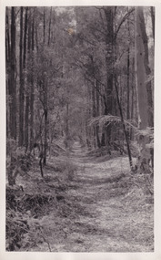
Photograph, Christmas 1941
... areas of the water reserves of Victoria. It is also linked to political identity of George Briscoe Kerferd and the Beechworth Municipal Council. lake kerferd beechworth water scheme water reserve forest track forest pathway reservoir Legislative Assembly Hon. George Briscoe Kerferd catchments ...Taken on Christmas of 1941, shown is a track to Lake Kerferd with forest on both sides. The construction on Lake Kerferd began in 1862 however it wasn't completed until 1874 due to engineering and funding issues. The lake was named after George Briscoe Kerferd (1831–1889) who was responsible for Beechworth's water scheme. George Briscoe Kerferd was born on 21 January 1831 in Liverpool, England and arrived in Melbourne April 1853. He spent his first years in Australia in Bendigo before settling down in Beechworth as a wine and spirits merchant. He married Ann Martindale on 17th December 1853 at St James Cathedral, Melbourne and between them they had three sons and five daughters. Kerferd began his political and legal career in Beechworth when he was first elected to the Municipal Council in May 1857. Later he would be elected to the Legislative Assembly for the Ovens District in November 1864, and continued to represent the area until February 1886.This photograph is historically significant as it provides insight into surrounding areas of the water reserves of Victoria. It is also linked to political identity of George Briscoe Kerferd and the Beechworth Municipal Council.Black and white rectangular photograph printed on matte photographic paper.Obverse: Reverse: 8163/ Back track to Lake Kerford/ Beechworth/ Xmas 1941lake kerferd, beechworth, water scheme, water reserve, forest track, forest pathway, reservoir, legislative assembly, hon. george briscoe kerferd, catchments, beechworth water reserve, beechworth catchments, municipal council, st. james cathedral, lakes, reserve, water supply, political projects -
 The Beechworth Burke Museum
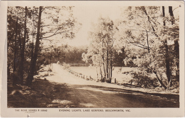
Photograph - Post Card, Rose Series Stereograph Co. Postcard
... It also presents information on the environmental development or degradation for the area, with possible changes to the environment that may have been caused by human physical forces, natural decay or Global Warming. Lake Kerferd Beechworth water scheme water reserve reservoir Legislative Assembly Hon. George Briscoe Kerferd catchments ...The construction on Lake Kerferd began in 1862 however it wasn't completed until 1874 due to engineering and funding issues. The lake was named after George Briscoe Kerferd (1831–1889) who was responsible for Beechworth's water scheme. George Briscoe Kerferd was born on 21 January 1831 in Liverpool, England and arrived in Melbourne April 1853. He spent his first years in Australia in Bendigo before settling down in Beechworth as a wine and spirits merchant. He married Ann Martindale on 17th December 1853 at St James Cathedral, Melbourne and between them they had three sons and five daughters. Kerferd began his political and legal career in Beechworth when he was first elected to the Municipal Council in May 1857. Later he would be elected to the Legislative Assembly for the Ovens District in November 1864, and continued to represent the area until February 1886. The postcard holds Historic significance due to its connection to Beechworth and its Lake Kerford. It demonstrates the interactions between nature and colonialists, especially how the lake has somewhat been 'protected' with the man made fencing. It also presents information on the environmental development or degradation for the area, with possible changes to the environment that may have been caused by human physical forces, natural decay or Global Warming.Sepia rectangular postcard printed on paper.Obverse: The Rose Series P. 10542 / Copyright / Evening lights, Lake Kerferd, Beechworth, VIC Reverse: Farley / Published by the Rose Stereograph Co., / Armadale Victoria. / 84-132-1 / Post card / The "Rose" Series De Luxe / A Real Photograph Produced in Australia / BMM299 lake kerferd, beechworth, water scheme, water reserve, reservoir, legislative assembly, hon. george briscoe kerferd, catchments, beechworth water reserve, beechworth catchments, municipal council, st. james cathedral, lakes, reserve, water supply, political projects, rose series, postcard, rose series stereograph -
 The Beechworth Burke Museum
Photograph, 1960s
... area and to make the water cleaner. Another redevelopment in the 1940s was made possible by the Beechworth and District Progress Association. It involved raising the banks to five feet to provide swimming facilities, paddling pool and caravan park. This photograph holds Historic significance because of its connection to the development of Beechworth district. Beechworth water scheme water reserve catchments ...Taken around 1960s, this photograph shows the banks of Lake Sambell. Lake Sambell is named after Mr. L. H. Sambell who was instrumental in the lake's formation. Lake Sambell is the original site of the open sluice operation of Rocky Mountain Mining Company in the 1800s and the early 1900s. In the early 1920s, it was reconstructed as a recreational lake and was formally opened to public on 6 October 1928. The opening event was attended by townspeople and Beechworth's Minister of Lands Mr. Bailey. In the late 1930s to early 1940s, Lake Sambell redeveloped. The first development aimed to raise the banks by six feet to double its present area and to make the water cleaner. Another redevelopment in the 1940s was made possible by the Beechworth and District Progress Association. It involved raising the banks to five feet to provide swimming facilities, paddling pool and caravan park. This photograph holds Historic significance because of its connection to the development of Beechworth district.Sepia rectangular photograph printed on matte photographic paperObverse: Reverse: 3533 /beechworth, water scheme, water reserve, catchments, beechworth water reserve, beechworth catchments, municipal council, lakes, reserve, water supply, political projects, environmental changes, mr. l. h. sambell, sambell, rocky mountain mining company, recreational lake, minister of lands, mr. bailey, swimming pool, paddling pool, caravan park, swimming facilities, lake redevelopment, funding -
 Halls Gap & Grampians Historical Society
Photograph - Sepia, C 1909
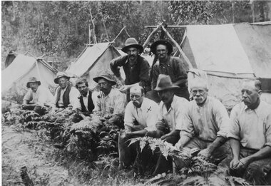
... catchment area of the creek, beside Silverband Road. For further information see: 'Bridging the Gap' by Ida Stanton, p. 49 and 'Victoria's Wonderland' by Halls Gap and Grampians Historical Society, p. 41. WATER ...Grampians halls Gap at Stoney Creek Dredge. The site of the Stoney Creek diggings was in the upper catchment area of the creek, beside Silverband Road. For further information see: 'Bridging the Gap' by Ida Stanton, p. 49 and 'Victoria's Wonderland' by Halls Gap and Grampians Historical Society, p. 41.Photo shows eight men seated, two standing, 3 tents in background. 2nd right Alfred D'Alton 4th Right James Oliverwater supplies, d'alton, water supplies, channels -
 Eltham District Historical Society Inc
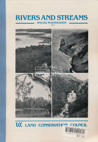
Book, Land Conservation Council, Rivers and Streams: Special Investigation, September 1989
... water authorities. The investigation resulted in a legislated system of 17 heritage rivers (with significant natural, recreational, scenic and heritage values) and natural catchment areas across Victoria....water authorities. The investigation resulted in a legislated system of 17 heritage rivers (with significant natural, recreational, scenic and heritage values) and natural catchment areas across Victoria. ...In June 1987, the government directed the LCC to carry out a special investigation of the social, recreational, cultural and ecological values of rivers and streams in Victoria, and to make recommendations on the use of these rivers and how their identified values can best be protected. Notices announcing the commencement of the investigation were published in the Victoria Government Gazette and in Victorian newspapers in November 1987. A descriptive report was published in September 1989. The Council received 75 submissions following the publication of this report. After considering these submissions, the Council formulated its proposed recommendations, which were published in November 1990. The Council received 177 submissions commenting on the proposed recommendations. The Council published its final recommendations in June 1991. While welcomed by many, the study cut across the interests of other groups and was perceived to be particularly threatening to water authorities. The investigation resulted in a legislated system of 17 heritage rivers (with significant natural, recreational, scenic and heritage values) and natural catchment areas across Victoria. -
 Eltham District Historical Society Inc
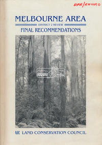
Book, Land Conservation Council, Melbourne Area, District 2 Review: Final Recommendations, 1994
... Timber resources and water quality and yield from timbered catchment areas remained significant issues in Melbourne’s catchments. ...Timber resources and water quality and yield from timbered catchment areas remained significant issues in Melbourne’s catchments. ...Notices showing the boundary of the area of the review and advising that an investigation was to be carried out were published in the Victoria Government Gazette and in local and other Victorian newspapers in May 1987. A descriptive resources report was published in August 1991. Council received 1,425 submissions and letters following publication of the descriptive report. The Council considered these submissions and published proposed recommendations in April 1993. A further 1,993 submissions were received in response to the proposed recommendations. The Council published its final recommendations in July 1994. A change to legislation in 1989 enabled the LCC to make recommendations for public land within a ‘town’, though cities and rural cities remained excluded from the definition of public land. Timber resources and water quality and yield from timbered catchment areas remained significant issues in Melbourne’s catchments. Recommendations for the Yarra Ranges National Park were based around the closed Melbourne water catchments and adjoining state forest. A recommended Phillip Island State Park based around the penguin reserve was ultimately implemented as the Phillip Island Nature Park.Shire of Nillumbik DPE/Enviro -
 Eltham District Historical Society Inc
Photograph, Upper Yarra Dam, Spring Tour, 22 Oct 1995, 22/10/1995
... catchment area). Finished in 1957 after ten years work and 100 years after Yan Yean, it supplies much of Melbourne's water. ...catchment area). Finished in 1957 after ten years work and 100 years after Yan Yean, it supplies much of Melbourne's water. ...EXPLORING THE UPPER YARRA (Newsletter No. 105, November 1995, by Bettina Woodburn) We enjoyed the Spring Excursion, this year "Exploring the Upper Yarra" - in spite of the constant rain and the countryside under the cloud cover, especially in the valleys, being mainly shiny shades of green. The occasional fields of buttercups, clumps of arum lilies and splendid rhododendron and other flowering bushes became very special. The Cobb and Co coach was warm and a cosy retreat as we zig-zagged on the highways and byways to glimpse the Yarra River, upstream and down, its secret places, and particularly the many bridges. Russell excelled as 'Poet Laureate', reading from Dacre Smyth's book. This 1979 publication includes paintings of all the bridges along the river with poems and brief descriptions of each one. Some of the bridges are in out of the way places and are not very well known. We looked forward to hearing the poetry as much as seeing the ' constructions'…Big Pat (was he short or tall, lean or fat? He did win the two hundred pound reward for discovering gold and had the creek named after him), about the 'Eddies'?, and the disliked 'meccano' bridge in Warburton, etc. etc. The hot roast lunch in the old Reefton Hotel was also most welcome. It was easy to imagine it peopled by miners and early settlers. Starting by crossing the new (1974) concrete bridge at Warrandyte we headed through Wonga Park with views to the Christmas Hills and to the escarpment of the Yering Gorge, which causes flood waters to back up through the Yarra Glen plain, so avoiding disasters downstream. At the end of a long driveway we found the wooden, privately owned Henley Bridge (1935 after the 1934 floods). This facilitates access to different parts of Henley Farm and to Lilydale. Everard Park, named after Blanche Shallard's father, a State Member for 17 years, below the Highway Yarra crossing was in need of care. It is 10 miles from Yarra Glen by road but, as "Yarra Marra” canoeists well know, 32 winding miles down by water. After more delightful countryside scenes we joined the Warburton Highway at Woori Yallock. From the old Railway Station at Launching Place the Centennial Trail for walkers, cyclists and ' horse riders has replaced the rails. The line from Lilydale was opened in 1901, and the last diesel freight train ran to Warburton in 1965. It continued to rain as we had morning tea in Warburton in a shelter between footbridges. From here we continued upstream past the Bridge to O'Shannasy Lodge and Reservoir, Starvation Creek, and the Peninsular tunnel (miners dug it as at Pound Bend) which we visited (scrambling down those steps!) on our return after lunch. Our furthermost point was the Upper Yarra Dam Reserve (and vast catchment area). Finished in 1957 after ten years work and 100 years after Yan Yean, it supplies much of Melbourne's water. After crossing the 30m Launching Place Bridge to the Eltham side of the Yarra and Healesville, we saw in the distance the Yarra Glen Timber Trestle Bridge over the river flats "the longest for years in the land it was said!" Harry's dream of "better weather over the Divide" unfortunately didn't come true, but I'm sure we 36 members will retain happy memories of a day that was wet and green and filled with Bridges. Bettina Woodburn - October 1995 Record of the Society's history of activities - Spring 1995 excursionRoll of 35mm colour negative film, 3 stripsKodak Gold 200-4shire of eltham historical society, activities, upper yarra dam, henley bridge -
 Eltham District Historical Society Inc
Photograph, Upper Yarra Dam, Spring Tour, 22 Oct 1995, 22/10/1995
... catchment area). Finished in 1957 after ten years work and 100 years after Yan Yean, it supplies much of Melbourne's water. ...catchment area). Finished in 1957 after ten years work and 100 years after Yan Yean, it supplies much of Melbourne's water. ...EXPLORING THE UPPER YARRA (Newsletter No. 105, November 1995, by Bettina Woodburn) We enjoyed the Spring Excursion, this year "Exploring the Upper Yarra" - in spite of the constant rain and the countryside under the cloud cover, especially in the valleys, being mainly shiny shades of green. The occasional fields of buttercups, clumps of arum lilies and splendid rhododendron and other flowering bushes became very special. The Cobb and Co coach was warm and a cosy retreat as we zig-zagged on the highways and byways to glimpse the Yarra River, upstream and down, its secret places, and particularly the many bridges. Russell excelled as 'Poet Laureate', reading from Dacre Smyth's book. This 1979 publication includes paintings of all the bridges along the river with poems and brief descriptions of each one. Some of the bridges are in out of the way places and are not very well known. We looked forward to hearing the poetry as much as seeing the ' constructions'…Big Pat (was he short or tall, lean or fat? He did win the two hundred pound reward for discovering gold and had the creek named after him), about the 'Eddies'?, and the disliked 'meccano' bridge in Warburton, etc. etc. The hot roast lunch in the old Reefton Hotel was also most welcome. It was easy to imagine it peopled by miners and early settlers. Starting by crossing the new (1974) concrete bridge at Warrandyte we headed through Wonga Park with views to the Christmas Hills and to the escarpment of the Yering Gorge, which causes flood waters to back up through the Yarra Glen plain, so avoiding disasters downstream. At the end of a long driveway we found the wooden, privately owned Henley Bridge (1935 after the 1934 floods). This facilitates access to different parts of Henley Farm and to Lilydale. Everard Park, named after Blanche Shallard's father, a State Member for 17 years, below the Highway Yarra crossing was in need of care. It is 10 miles from Yarra Glen by road but, as "Yarra Marra” canoeists well know, 32 winding miles down by water. After more delightful countryside scenes we joined the Warburton Highway at Woori Yallock. From the old Railway Station at Launching Place the Centennial Trail for walkers, cyclists and ' horse riders has replaced the rails. The line from Lilydale was opened in 1901, and the last diesel freight train ran to Warburton in 1965. It continued to rain as we had morning tea in Warburton in a shelter between footbridges. From here we continued upstream past the Bridge to O'Shannasy Lodge and Reservoir, Starvation Creek, and the Peninsular tunnel (miners dug it as at Pound Bend) which we visited (scrambling down those steps!) on our return after lunch. Our furthermost point was the Upper Yarra Dam Reserve (and vast catchment area). Finished in 1957 after ten years work and 100 years after Yan Yean, it supplies much of Melbourne's water. After crossing the 30m Launching Place Bridge to the Eltham side of the Yarra and Healesville, we saw in the distance the Yarra Glen Timber Trestle Bridge over the river flats "the longest for years in the land it was said!" Harry's dream of "better weather over the Divide" unfortunately didn't come true, but I'm sure we 36 members will retain happy memories of a day that was wet and green and filled with Bridges. Bettina Woodburn - October 1995 Record of the Society's history of activities - Spring 1995 excursionRoll of 35mm colour negative film, 2 stripsKodak Gold 100-4shire of eltham historical society, activities, upper yarra dam, henley bridge -
 Eltham District Historical Society Inc
Photograph, Upper Yarra Dam, Spring Tour, 22 Oct 1995, 22/10/1995
... catchment area). Finished in 1957 after ten years work and 100 years after Yan Yean, it supplies much of Melbourne's water. ...catchment area). Finished in 1957 after ten years work and 100 years after Yan Yean, it supplies much of Melbourne's water. ...EXPLORING THE UPPER YARRA (Newsletter No. 105, November 1995, by Bettina Woodburn) We enjoyed the Spring Excursion, this year "Exploring the Upper Yarra" - in spite of the constant rain and the countryside under the cloud cover, especially in the valleys, being mainly shiny shades of green. The occasional fields of buttercups, clumps of arum lilies and splendid rhododendron and other flowering bushes became very special. The Cobb and Co coach was warm and a cosy retreat as we zig-zagged on the highways and byways to glimpse the Yarra River, upstream and down, its secret places, and particularly the many bridges. Russell excelled as 'Poet Laureate', reading from Dacre Smyth's book. This 1979 publication includes paintings of all the bridges along the river with poems and brief descriptions of each one. Some of the bridges are in out of the way places and are not very well known. We looked forward to hearing the poetry as much as seeing the ' constructions'…Big Pat (was he short or tall, lean or fat? He did win the two hundred pound reward for discovering gold and had the creek named after him), about the 'Eddies'?, and the disliked 'meccano' bridge in Warburton, etc. etc. The hot roast lunch in the old Reefton Hotel was also most welcome. It was easy to imagine it peopled by miners and early settlers. Starting by crossing the new (1974) concrete bridge at Warrandyte we headed through Wonga Park with views to the Christmas Hills and to the escarpment of the Yering Gorge, which causes flood waters to back up through the Yarra Glen plain, so avoiding disasters downstream. At the end of a long driveway we found the wooden, privately owned Henley Bridge (1935 after the 1934 floods). This facilitates access to different parts of Henley Farm and to Lilydale. Everard Park, named after Blanche Shallard's father, a State Member for 17 years, below the Highway Yarra crossing was in need of care. It is 10 miles from Yarra Glen by road but, as "Yarra Marra” canoeists well know, 32 winding miles down by water. After more delightful countryside scenes we joined the Warburton Highway at Woori Yallock. From the old Railway Station at Launching Place the Centennial Trail for walkers, cyclists and ' horse riders has replaced the rails. The line from Lilydale was opened in 1901, and the last diesel freight train ran to Warburton in 1965. It continued to rain as we had morning tea in Warburton in a shelter between footbridges. From here we continued upstream past the Bridge to O'Shannasy Lodge and Reservoir, Starvation Creek, and the Peninsular tunnel (miners dug it as at Pound Bend) which we visited (scrambling down those steps!) on our return after lunch. Our furthermost point was the Upper Yarra Dam Reserve (and vast catchment area). Finished in 1957 after ten years work and 100 years after Yan Yean, it supplies much of Melbourne's water. After crossing the 30m Launching Place Bridge to the Eltham side of the Yarra and Healesville, we saw in the distance the Yarra Glen Timber Trestle Bridge over the river flats "the longest for years in the land it was said!" Harry's dream of "better weather over the Divide" unfortunately didn't come true, but I'm sure we 36 members will retain happy memories of a day that was wet and green and filled with Bridges. Bettina Woodburn - October 1995 Record of the Society's history of activities - Spring 1995 excursionRoll of 35mm colour negative film, 4 of 5 stripsKodak Gold 400-5shire of eltham historical society, activities, upper yarra dam, henley bridge -
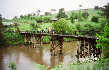
 Eltham District Historical Society Inc
Photograph, Henley Bridge, Spring Excursion, Exploring the Upper Yarra, 22 October 1995, 22/10/1995
... catchment area). Finished in 1957 after ten years' work and 100 years after Yan Yean, it supplies much of Melbourne's water. ...catchment area). Finished in 1957 after ten years' work and 100 years after Yan Yean, it supplies much of Melbourne's water. ...[article by Bettina Woodburn in EDHS Newsletter No. 105, November 1995:] EXPLORING THE UPPER YARRA - We enjoyed the Spring Excursion, this year "Exploring the Upper Yarra" - in spite of the constant rain and the countryside under the cloud cover, especially in the valleys, being mainly shiny shades of green. The occasional fields of buttercups, clumps of arum lilies and splendid rhododendron and other flowering bushes became very special. The Cobb and Co coach was warm and a cosy retreat as we zig-zagged on the highways and byways to glimpse the Yarra River, upstream and down, its secret places, and particularly the many bridges. Russell excelled as 'Poet Laureate', reading from Dacre Smyth's book. This 1979 publication includes paintings of all the bridges along the river with poems and brief descriptions of each one. Some of the bridges are in out-of-the-way places and are not very well known. We looked forward to hearing the poetry as much as seeing the 'constructions'… Big Pat (was he short or tall, lean or fat? - he did win the £200 reward for discovering gold and had the creek named after him), about the 'Eddies'?, and the disliked 'meccano' bridge in Warburton, etc. etc. The hot roast lunch in the old Reefton Hotel was also most welcome. It was easy to imagine it peopled by miners and early settlers. Starting by crossing the new (1974) concrete bridge at Warrandyte we headed through Wonga Park with views to the Christmas Hills and to the escarpment of the Yering Gorge, which causes flood waters to back up through the Yarra Glen plain, so avoiding disasters downstream. At the end of a long driveway we found the wooden, privately owned Henley Bridge (1935 after the 1934 floods). This facilitates access to different parts of Henley Farm and to Lilydale. Everard Park, named after Blanche Shallard's father, a State Member for 17 years, below the Highway Yarra crossing was in need of care. It is 10 miles from Yarra Glen by road but, as "Yarra Marra” canoeists well know, 32 winding miles down by water. After more delightful countryside scenes we joined the Warburton Highway at Woori Yallock. From the old Railway Station at Launching Place the Centennial Trail for walkers, cyclists and horse riders has replaced the rails. The line from Lilydale was opened in 1901, and the last diesel freight train ran to Warburton in 1965. It continued to rain as we had morning tea in Warburton in a shelter between footbridges. From here we continued upstream past the Bridge to O'Shannassy Lodge and Reservoir, Starvation Creek, and the Peninsular tunnel (miners dug it as at Pound Bend) which we visited (scrambling down those steps!) on our return after lunch. Our furthermost point was the Upper Yarra Dam Reserve (and vast catchment area). Finished in 1957 after ten years' work and 100 years after Yan Yean, it supplies much of Melbourne's water. After crossing the 30m Launching Place Bridge to the Eltham side of the Yarra and Healesville, we saw in the distance the Yarra Glen Timber Trestle Bridge over the river flats "the longest for years in the land it was said!" Harry's dream of "better weather over the Divide" unfortunately didn't come true, but I'm sure we 36 members will retain happy memories of a day that was wet and green and filled with Bridges. Situated on the Yarra River, 5.5 kms south of Christmas Hills on private property. This timber trestle bridge is said to have been built some time after 1907 by Melbourne master-builder, David Mitchell (the father of Dame Nellie Melba), to connect his two "Henley Farm" properties with Lilydale. In earlier days, when the McPhersons owned the property, their children used a punt to cross the river to attend Yering Primary School. This private bridge is best viewed from the end of Wendy Way. - Source: Christmas Hills Past and Present, Yarra Glen & District Historical Society, 2004.Two colour photographsactivities, henley bridge, upper yarra -
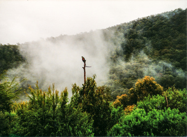 Eltham District Historical Society Inc
Photograph, Spring Excursion, Exploring the Upper Yarra, 22 October 1995, 22/10/1995
... catchment area). Finished in 1957 after ten years' work and 100 years after Yan Yean, it supplies much of Melbourne's water. ...catchment area). Finished in 1957 after ten years' work and 100 years after Yan Yean, it supplies much of Melbourne's water. ...[article by Bettina Woodburn in EDHS Newsletter No. 105, November 1995:] EXPLORING THE UPPER YARRA - We enjoyed the Spring Excursion, this year "Exploring the Upper Yarra" - in spite of the constant rain and the countryside under the cloud cover, especially in the valleys, being mainly shiny shades of green. The occasional fields of buttercups, clumps of arum lilies and splendid rhododendron and other flowering bushes became very special. The Cobb and Co coach was warm and a cosy retreat as we zig-zagged on the highways and byways to glimpse the Yarra River, upstream and down, its secret places, and particularly the many bridges. Russell excelled as 'Poet Laureate', reading from Dacre Smyth's book. This 1979 publication includes paintings of all the bridges along the river with poems and brief descriptions of each one. Some of the bridges are in out-of-the-way places and are not very well known. We looked forward to hearing the poetry as much as seeing the 'constructions'… Big Pat (was he short or tall, lean or fat? - he did win the £200 reward for discovering gold and had the creek named after him), about the 'Eddies'?, and the disliked 'meccano' bridge in Warburton, etc. etc. The hot roast lunch in the old Reefton Hotel was also most welcome. It was easy to imagine it peopled by miners and early settlers. Starting by crossing the new (1974) concrete bridge at Warrandyte we headed through Wonga Park with views to the Christmas Hills and to the escarpment of the Yering Gorge, which causes flood waters to back up through the Yarra Glen plain, so avoiding disasters downstream. At the end of a long driveway we found the wooden, privately owned Henley Bridge (1935 after the 1934 floods). This facilitates access to different parts of Henley Farm and to Lilydale. Everard Park, named after Blanche Shallard's father, a State Member for 17 years, below the Highway Yarra crossing was in need of care. It is 10 miles from Yarra Glen by road but, as "Yarra Marra” canoeists well know, 32 winding miles down by water. After more delightful countryside scenes we joined the Warburton Highway at Woori Yallock. From the old Railway Station at Launching Place the Centennial Trail for walkers, cyclists and horse riders has replaced the rails. The line from Lilydale was opened in 1901, and the last diesel freight train ran to Warburton in 1965. It continued to rain as we had morning tea in Warburton in a shelter between footbridges. From here we continued upstream past the Bridge to O'Shannassy Lodge and Reservoir, Starvation Creek, and the Peninsular tunnel (miners dug it as at Pound Bend) which we visited (scrambling down those steps!) on our return after lunch. Our furthermost point was the Upper Yarra Dam Reserve (and vast catchment area). Finished in 1957 after ten years' work and 100 years after Yan Yean, it supplies much of Melbourne's water. After crossing the 30m Launching Place Bridge to the Eltham side of the Yarra and Healesville, we saw in the distance the Yarra Glen Timber Trestle Bridge over the river flats "the longest for years in the land it was said!" Harry's dream of "better weather over the Divide" unfortunately didn't come true, but I'm sure we 36 members will retain happy memories of a day that was wet and green and filled with Bridges.Two colour photographsactivities, upper yarra, upper yarra dam -
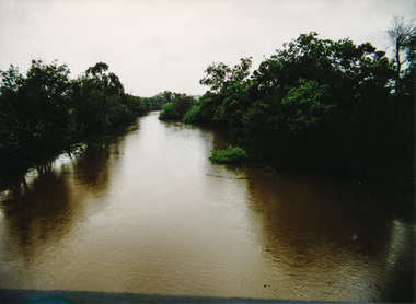 Eltham District Historical Society Inc
Photograph, Yarra River from Henley Bridge, Kangaroo Ground, Spring Excursion, Exploring the Upper Yarra, 22 October 1995, 22/10/1995
... catchment area). Finished in 1957 after ten years' work and 100 years after Yan Yean, it supplies much of Melbourne's water. ...catchment area). Finished in 1957 after ten years' work and 100 years after Yan Yean, it supplies much of Melbourne's water. ...[article by Bettina Woodburn in EDHS Newsletter No. 105, November 1995:] EXPLORING THE UPPER YARRA - We enjoyed the Spring Excursion, this year "Exploring the Upper Yarra" - in spite of the constant rain and the countryside under the cloud cover, especially in the valleys, being mainly shiny shades of green. The occasional fields of buttercups, clumps of arum lilies and splendid rhododendron and other flowering bushes became very special. The Cobb and Co coach was warm and a cosy retreat as we zig-zagged on the highways and byways to glimpse the Yarra River, upstream and down, its secret places, and particularly the many bridges. Russell excelled as 'Poet Laureate', reading from Dacre Smyth's book. This 1979 publication includes paintings of all the bridges along the river with poems and brief descriptions of each one. Some of the bridges are in out-of-the-way places and are not very well known. We looked forward to hearing the poetry as much as seeing the 'constructions'… Big Pat (was he short or tall, lean or fat? - he did win the £200 reward for discovering gold and had the creek named after him), about the 'Eddies'?, and the disliked 'meccano' bridge in Warburton, etc. etc. The hot roast lunch in the old Reefton Hotel was also most welcome. It was easy to imagine it peopled by miners and early settlers. Starting by crossing the new (1974) concrete bridge at Warrandyte we headed through Wonga Park with views to the Christmas Hills and to the escarpment of the Yering Gorge, which causes flood waters to back up through the Yarra Glen plain, so avoiding disasters downstream. At the end of a long driveway we found the wooden, privately owned Henley Bridge (1935 after the 1934 floods). This facilitates access to different parts of Henley Farm and to Lilydale. Everard Park, named after Blanche Shallard's father, a State Member for 17 years, below the Highway Yarra crossing was in need of care. It is 10 miles from Yarra Glen by road but, as "Yarra Marra” canoeists well know, 32 winding miles down by water. After more delightful countryside scenes we joined the Warburton Highway at Woori Yallock. From the old Railway Station at Launching Place the Centennial Trail for walkers, cyclists and horse riders has replaced the rails. The line from Lilydale was opened in 1901, and the last diesel freight train ran to Warburton in 1965. It continued to rain as we had morning tea in Warburton in a shelter between footbridges. From here we continued upstream past the Bridge to O'Shannassy Lodge and Reservoir, Starvation Creek, and the Peninsular tunnel (miners dug it as at Pound Bend) which we visited (scrambling down those steps!) on our return after lunch. Our furthermost point was the Upper Yarra Dam Reserve (and vast catchment area). Finished in 1957 after ten years' work and 100 years after Yan Yean, it supplies much of Melbourne's water. After crossing the 30m Launching Place Bridge to the Eltham side of the Yarra and Healesville, we saw in the distance the Yarra Glen Timber Trestle Bridge over the river flats "the longest for years in the land it was said!" Harry's dream of "better weather over the Divide" unfortunately didn't come true, but I'm sure we 36 members will retain happy memories of a day that was wet and green and filled with Bridges.Colour photographactivities, upper yarra, henley bridge