Showing 26 items matching "water exploration"
-
 Narre Warren and District Family History Group
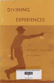
Book, William E Liversidge, Divining experiences, 1977
... ...water exploration...Narre Warren and District Family History Group 110 High Street Berwick melbourne divining dowsing water exploration William E Liversidge A book about water divining in Australia Divining experiences Book William E Liversidge ...A book about water divining in Australianon-fictionA book about water divining in Australiadivining, dowsing, water exploration, william e liversidge -
 Sunshine and District Historical Society Incorporated
Document - A Journal of the exploration of Charles Grimes Acting Surveyor General of New South Wales
... The Voyage of his Majesty Colonial Schooner Cumberland from Sydney to King Island and Port Phillip in 1802 to 1803|A Journal of the exploration of Charles Grimes Acting Surveyor General of New South Wales|Salt Water River exploration...From the Gwenyth Gwen Marie Goedecke Donation Charles Grimes The Voyage of his Majesty Colonial Schooner Cumberland from Sydney to King Island and Port Phillip in 1802 to 1803|A Journal of the exploration of Charles Grimes Acting Surveyor General of New South Wales|Salt Water River exploration A copy of the Journal of the exploration of Charles Grimes Acting Surveyor General of New South Wales Document A Journal of the exploration of Charles Grimes Acting Surveyor General of New South Wales ...From the Gwenyth Gwen Marie Goedecke DonationThe Voyage of his Majesty Colonial Schooner Cumberland from Sydney to King Island and Port Phillip in 1802 to 1803|A Journal of the exploration of Charles Grimes Acting Surveyor General of New South Wales|Salt Water River explorationcharles grimes -
 Warrnambool and District Historical Society Inc.
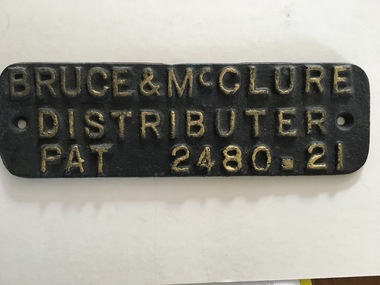
Brass Plate, Bruce & McClure Distributer, C early 20th century
... They won 11 first prizes at the Grand national Show of 1907 and in 1914 designed and manufactured a new water boring machine which could also be used for oil and gold exploration They operated from Lava Street well into the 1940's as well as from the geelong area. ...They won 11 first prizes at the Grand national Show of 1907 and in 1914 designed and manufactured a new water boring machine which could also be used for oil and gold exploration They operated from Lava Street well into the 1940's as well as from the geelong area. ...Bruce & McClure were manufacturers of windmills and agricultural machinery including motor engines , pumps, tanks,and appliances for supplying and conserving water.Also included was brass,iron and steel foundry works. They won 11 first prizes at the Grand national Show of 1907 and in 1914 designed and manufactured a new water boring machine which could also be used for oil and gold exploration They operated from Lava Street well into the 1940's as well as from the geelong area. This plaque is possibly from one of their machines.A tangible link to one of Warrnambool's manufacturing businesses which was innovative and an essential part of the beginnings of machine use in farms and industry in the district. Cast iron plaque with moulded text which is coloured in gold. rectangular with rounded corners. Back is painted grey.Bruce & McClure Distributer Pat 2480.21warrnambool, bruce & mcclure, bruce & mcclure machinery -
 Kiewa Valley Historical Society
Report - Alpine Study Area Volume 2 Maps, Land Conservation Council, 1970s
... Rainfall and water resources may change over the years thus providing a comparative analysis. Others may provide information for future development such as mineral exploration, building of a dam / tunnel etc. alpine area maps of alpine area land conservation council Ex library item. ...The Victorian Environmental Assessment Council and the former Environment Conservation Council (ECC) and Land Conservation Council (LCC) have completed 36 land use investigations over more than 35 years, including 27 regional reviews. They provide a framework for use of Public Land in Victoria. The Land Conservation Council was established by the Land Conservation Act 1970.These maps provide an assessment of the Alpine area at the time the maps were created. Some of the topics eg. Rainfall and water resources may change over the years thus providing a comparative analysis. Others may provide information for future development such as mineral exploration, building of a dam / tunnel etc.Blue box shaped folder containing 9 of 10 Maps of the Alpine Study Area produced by the Land Conservation Council. Maps include 1. Public land and descriptive blocks. 2. Physiography. 3. Topography. 4. Geology (missing). 5. Rainfall and water resources. 6. Vegetation 7. Land systems. 8. Recreation. 9. Primary production. 10. Minerals Ex library item. Stamped in red "Discarded From Stock / Swan Hill Regional Libraryalpine area, maps of alpine area, land conservation council -
 Kiewa Valley Historical Society
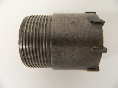
Drill Bit Diamond, circa mid to late 1900's
... exploration resulting in a "coring" of rock. The use of "coring" to obtained samples for the SEC Kiewa Hydro Electricity Scheme(1920's onward) was to analyse the core to obtain temperature and rainfall patterns shown by the levels of layered solidified soil(rock). This diamond drill would have been used in the early 1900's to provide a sub strata map of temperature and water...exploration resulting in a "coring" of rock. The use of "coring" to obtained samples for the SEC Kiewa Hydro Electricity Scheme(1920's onward) was to analyse the core to obtain temperature and rainfall patterns shown by the levels of layered solidified soil(rock). This diamond drill would have been used in the early 1900's to provide a sub strata map of temperature and water ...This hollow core bit has hard cutting inserts for drilling into rock. It was used to drill and recover 50mm diameter (most common size) rock cores. The rock cores were assessed by geologists and engineers to provide information for design of structures such as tunnels, dams and underground power stations (eg. McKay Creek Power Station, West Kiewa Power Station). This type of bit was also used where damage to the surrounding rock had to be minimised. The Diamond Drill Bit,used in the early 1900's, when it was primarily used as a method of sampling rock for ore deposits and oil exploration resulting in a "coring" of rock. The use of "coring" to obtained samples for the SEC Kiewa Hydro Electricity Scheme(1920's onward) was to analyse the core to obtain temperature and rainfall patterns shown by the levels of layered solidified soil(rock). This diamond drill would have been used in the early 1900's to provide a sub strata map of temperature and water patterns (over an long period of time). This was a pre requisite to any decisions about the viability of the region to provide the water needed for a successful hydro electricity scheme.This diamond drill for core sampling was at the forefront of the analysis whether to construct a hydro electrical facility in the Kiewa Valley and the adjoining alpine region. The rock core samples produced were assessed by geologists and structural engineers. It was only after extensive core drilling covering the region that solid scientific evidence could be provided to start the "SEC Vic Hydro Electricity Scheme" within its current boundaries.This "diamond" drill bit has eight "teeth" at its cutting edge. The drill creates an 55mm hole in extremely hard rock material to obtain 50mm core samples.. Three quarters down the shank it has thread screw channels to attach the bit to the drill pipe. The coring pipe attaches via screwing it onto this bit. Core samples are the main objective of this tool.alternate energy supplies, alpine feasibility studies temperature, rainfall, sec, kiewa hydro electric scheme, electricity -
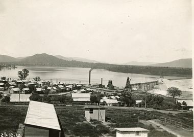
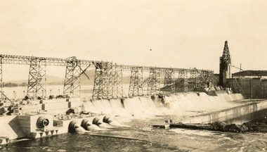 The Beechworth Burke Museum
Photograph
... exploration journey in 1824 and thought they discovered a river, which turned out to be the Murray River. They returned home in 1825, but returned to the area in 1826 and discovered coal in the area. This photo is historically significant as it shows the Hume Dam under construction in 1930. The Dam was named after Hamilton Hume, who is an important historical figure for this area as he helped discover the area where resources were found. construction houses veterans Mitta Junction Village Hume Dam World War I Federation Wodonga Archaeological survey excavation Austral Archaeology Department of Land & Water Conservation Camp Ganger's Quarter's Stableman's Quarters Industrial Dump artefacts Mitta Mitta Mount Welcome Mount Misery Murray River Hamilton Hume William Hilton Hovell Hume and Hovell expedition Reverse: 84-19-5 / 1997.3185/ Values & spillway. / When completed the wall / will be as high as the / scaffolding. ...Taken on 25 October 1930, various houses with the Hume Dam under construction are depicted in the background. The construction of the Hume Dam took place from 1919 to 1936. At the time of construction, it was the second largest dam in the world. It was also one of the earliest civil projects developed after the Federation. Some of the Dam workers consisted of World War I veterans. Dam workers often settled their families in Mitta Junction Village and Wodonga. Archaeological surveys were completed by Austral Archaeology, which was done when the Department of Land & Water Conservation was doing work to improve Hume Dam. The archaeological report that came out of the survey recommended three sites of interest where archaeological excavation should be done: Camp Ganger’s Quarters, Stableman’s Quarters, and the Industrial Dump. The excavation uncovered artefacts. Mitta Mitta: Mitta Mitta is situated between Mount Welcome and Mount Misery. It is named after the river that explorers Hume and Hovell discovered in 1824. The town would eventually become a huge gold mining town. Mitta Mitta is called Midamodunga by the local Indigenous peoples Wodonga: Wodonga is situated on the Murray River and is part of North East Victoria. Hume and Hovell: Hamilton Hume (1979-1873) and William Hilton Hovell (1786-1875). W. H. Hovell was born in Norfolk England and Hume was born in Parramatta, New South Wales Hovell and Hume undertook an exploration journey in 1824 and thought they discovered a river, which turned out to be the Murray River. They returned home in 1825, but returned to the area in 1826 and discovered coal in the area. This photo is historically significant as it shows the Hume Dam under construction in 1930. The Dam was named after Hamilton Hume, who is an important historical figure for this area as he helped discover the area where resources were found.Sepia rectangular photograph printed unmountedReverse: 84-19-5 / 1997.3185/ Values & spillway. / When completed the wall / will be as high as the / scaffolding. [featuring trademark: kodak print]construction, houses, veterans, mitta junction village, hume dam, world war i, federation, wodonga, archaeological survey, excavation, austral archaeology, department of land & water conservation, camp ganger's quarter's, stableman's quarters, industrial dump, artefacts, mitta mitta, mount welcome, mount misery, murray river, hamilton hume, william hilton hovell, hume and hovell expedition -
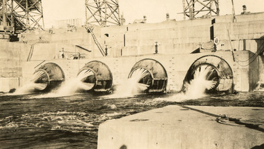 The Beechworth Burke Museum
Photograph, c1930
... exploration journey in 1824 and thought they discovered a river, which turned out to be the Murray River. They returned home in 1825, but returned to the area in 1826 and discovered coal in the area. This photo is historically significant as it shows the Hume Dam under construction in 1930. The Dam was named after Hamilton Hume, who is an important historical figure for this area as he helped discover the area where resources were found. construction houses veterans Mitta Junction Village Hume Dam World War I Federation Wodonga Archaeological survey excavation Austral Archaeology Department of Land & Water Conservation Camp Ganger's Quarter's Stableman's Quarters Industrial Dump artefacts Mitta Mitta Mount Welcome Mount Misery Murray River Hamilton Hume William Hilton Hovell Hume and Hovell expedition Reverse: 84-19-2/ 1997.3188/ These are the four / release valves they are / not always open (illegible) this / when closed the water flows / over the spillway. ...Taken on 25 October 1930, various houses with the Hume Dam under construction are depicted in the background. The construction of the Hume Dam took place from 1919 to 1936. At the time of construction, it was the second largest dam in the world. It was also one of the earliest civil projects developed after the Federation. Some of the Dam workers consisted of World War I veterans. Dam workers often settled their families in Mitta Junction Village and Wodonga. Archaeological surveys were completed by Austral Archaeology, which was done when the Department of Land & Water Conservation was doing work to improve Hume Dam. The archaeological report that came out of the survey recommended three sites of interest where archaeological excavation should be done: Camp Ganger’s Quarters, Stableman’s Quarters, and the Industrial Dump. The excavation uncovered artefacts. Mitta Mitta: Mitta Mitta is situated between Mount Welcome and Mount Misery. It is named after the river that explorers Hume and Hovell discovered in 1824. The town would eventually become a huge gold mining town. Mitta Mitta is called Midamodunga by the local Indigenous peoples Wodonga: Wodonga is situated on the Murray River and is part of North East Victoria. Hume and Hovell: Hamilton Hume (1979-1873) and William Hilton Hovell (1786-1875). W. H. Hovell was born in Norfolk England and Hume was born in Parramatta, New South Wales Hovell and Hume undertook an exploration journey in 1824 and thought they discovered a river, which turned out to be the Murray River. They returned home in 1825, but returned to the area in 1826 and discovered coal in the area.This photo is historically significant as it shows the Hume Dam under construction in 1930. The Dam was named after Hamilton Hume, who is an important historical figure for this area as he helped discover the area where resources were found.Sepia rectangular photograph printed unmountedReverse: 84-19-2/ 1997.3188/ These are the four / release valves they are / not always open (illegible) this / when closed the water flows / over the spillway. [featuring trademark: kodak print] photograph number: 354construction, houses, veterans, mitta junction village, hume dam, world war i, federation, wodonga, archaeological survey, excavation, austral archaeology, department of land & water conservation, camp ganger's quarter's, stableman's quarters, industrial dump, artefacts, mitta mitta, mount welcome, mount misery, murray river, hamilton hume, william hilton hovell, hume and hovell expedition -
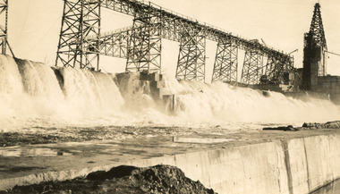 The Beechworth Burke Museum
Photograph, 25 October 1930
... exploration journey in 1824 and thought they discovered a river, which turned out to be the Murray River. They returned home in 1825, but returned to the area in 1826 and discovered coal in the area. This photo is historically significant as it shows the Hume Dam under construction in 1930. The Dam was named after Hamilton Hume, who is an important historical figure for this area as he helped discover the area where resources were found. construction houses veterans Mitta Junction Village Hume Dam World War I Federation Wodonga Archaeological survey excavation Austral Archaeology Department of Land & Water Conservation Camp Ganger's Quarter's Stableman's Quarters Industrial Dump artefacts Mitta Mitta Mount Welcome Mount Misery Murray River Hamilton Hume William Hilton Hovell Hume and Hovell expedition Reverse: 84-19-6/ 1997.3187/ The spillway [featuring trademark: kodak print] Sepia rectangular photograph printed unmounted Photograph Photograph ...Taken on 25 October 1930, various houses with the Hume Dam under construction are depicted in the background. The construction of the Hume Dam took place from 1919 to 1936. At the time of construction, it was the second largest dam in the world. It was also one of the earliest civil projects developed after the Federation. Some of the Dam workers consisted of World War I veterans. Dam workers often settled their families in Mitta Junction Village and Wodonga. Archaeological surveys were completed by Austral Archaeology, which was done when the Department of Land & Water Conservation was doing work to improve Hume Dam. The archaeological report that came out of the survey recommended three sites of interest where archaeological excavation should be done: Camp Ganger’s Quarters, Stableman’s Quarters, and the Industrial Dump. The excavation uncovered artefacts. Mitta Mitta: Mitta Mitta is situated between Mount Welcome and Mount Misery. It is named after the river that explorers Hume and Hovell discovered in 1824. The town would eventually become a huge gold mining town. Mitta Mitta is called Midamodunga by the local Indigenous peoples Wodonga: Wodonga is situated on the Murray River and is part of North East Victoria. Hume and Hovell: Hamilton Hume (1979-1873) and William Hilton Hovell (1786-1875). W. H. Hovell was born in Norfolk England and Hume was born in Parramatta, New South Wales Hovell and Hume undertook an exploration journey in 1824 and thought they discovered a river, which turned out to be the Murray River. They returned home in 1825, but returned to the area in 1826 and discovered coal in the area.This photo is historically significant as it shows the Hume Dam under construction in 1930. The Dam was named after Hamilton Hume, who is an important historical figure for this area as he helped discover the area where resources were found.Sepia rectangular photograph printed unmountedReverse: 84-19-6/ 1997.3187/ The spillway [featuring trademark: kodak print] construction, houses, veterans, mitta junction village, hume dam, world war i, federation, wodonga, archaeological survey, excavation, austral archaeology, department of land & water conservation, camp ganger's quarter's, stableman's quarters, industrial dump, artefacts, mitta mitta, mount welcome, mount misery, murray river, hamilton hume, william hilton hovell, hume and hovell expedition -
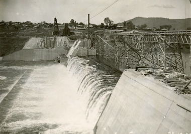 The Beechworth Burke Museum
Photograph, 25 October 1930
... exploration journey in 1824 and thought they discovered a river, which turned out to be the Murray River. They returned home in 1825, but returned to the area in 1826 and discovered coal in the area. This photo is historically significant as it shows the Hume Dam under construction in 1930. The Dam was named after Hamilton Hume, who is an important historical figure for this area as he helped discover the area where resources were found. construction houses veterans Mitta Junction Village Hume Dam World War I Federation Wodonga Archaeological survey excavation Austral Archaeology Department of Land & Water Conservation Camp Ganger's Quarter's Stableman's Quarters Industrial Dump artefacts Mitta Mitta Mount Welcome Mount Misery Murray River Hamilton Hume William Hilton Hovell Hume and Hovell expedition Reverse: 84-20-1/ 1997.3147 Black and white rectangular photograph printer unmounted Photograph Photograph ...Taken on 25 October 1930, various houses with the Hume Dam under construction are depicted in the background. The construction of the Hume Dam took place from 1919 to 1936. At the time of construction, it was the second largest dam in the world. It was also one of the earliest civil projects developed after the Federation. Some of the Dam workers consisted of World War I veterans. Dam workers often settled their families in Mitta Junction Village and Wodonga. Archaeological surveys were completed by Austral Archaeology, which was done when the Department of Land & Water Conservation was doing work to improve Hume Dam. The archaeological report that came out of the survey recommended three sites of interest where archaeological excavation should be done: Camp Ganger’s Quarters, Stableman’s Quarters, and the Industrial Dump. The excavation uncovered artefacts. Mitta Mitta: Mitta Mitta is situated between Mount Welcome and Mount Misery. It is named after the river that explorers Hume and Hovell discovered in 1824. The town would eventually become a huge gold mining town. Mitta Mitta is called Midamodunga by the local Indigenous peoples Wodonga: Wodonga is situated on the Murray River and is part of North East Victoria. Hume and Hovell: Hamilton Hume (1979-1873) and William Hilton Hovell (1786-1875). W. H. Hovell was born in Norfolk England and Hume was born in Parramatta, New South Wales Hovell and Hume undertook an exploration journey in 1824 and thought they discovered a river, which turned out to be the Murray River. They returned home in 1825, but returned to the area in 1826 and discovered coal in the area.This photo is historically significant as it shows the Hume Dam under construction in 1930. The Dam was named after Hamilton Hume, who is an important historical figure for this area as he helped discover the area where resources were found.Black and white rectangular photograph printer unmountedReverse: 84-20-1/ 1997.3147construction, houses, veterans, mitta junction village, hume dam, world war i, federation, wodonga, archaeological survey, excavation, austral archaeology, department of land & water conservation, camp ganger's quarter's, stableman's quarters, industrial dump, artefacts, mitta mitta, mount welcome, mount misery, murray river, hamilton hume, william hilton hovell, hume and hovell expedition -
 The Beechworth Burke Museum
Photograph, 25 October 1930
... exploration journey in 1824 and thought they discovered a river, which turned out to be the Murray River. They returned home in 1825, but returned to the area in 1826 and discovered coal in the area. This photo is historically significant as it shows the Hume Dam under construction in 1930. The Dam was named after Hamilton Hume, who is an important historical figure for this area as he helped discover the area where resources were found. construction houses veterans Mitta Junction Village Hume Dam World War I Federation Wodonga Archaeological survey excavation Austral Archaeology Department of Land & Water Conservation Camp Ganger's Quarter's Stableman's Quarters Industrial Dump artefacts Mitta Mitta Mount Welcome Mount Misery Murray River Hamilton Hume William Hilton Hovell Hume and Hovell expedition Reverse: 1997.3145/ 84-20-2 Black and white rectangular photograph printer unmounted Photograph Photograph ...Taken on 25 October 1930, various houses with the Hume Dam under construction are depicted in the background. The construction of the Hume Dam took place from 1919 to 1936. At the time of construction, it was the second largest dam in the world. It was also one of the earliest civil projects developed after the Federation. Some of the Dam workers consisted of World War I veterans. Dam workers often settled their families in Mitta Junction Village and Wodonga. Archaeological surveys were completed by Austral Archaeology, which was done when the Department of Land & Water Conservation was doing work to improve Hume Dam. The archaeological report that came out of the survey recommended three sites of interest where archaeological excavation should be done: Camp Ganger’s Quarters, Stableman’s Quarters, and the Industrial Dump. The excavation uncovered artefacts. Mitta Mitta: Mitta Mitta is situated between Mount Welcome and Mount Misery. It is named after the river that explorers Hume and Hovell discovered in 1824. The town would eventually become a huge gold mining town. Mitta Mitta is called Midamodunga by the local Indigenous peoples Wodonga: Wodonga is situated on the Murray River and is part of North East Victoria. Hume and Hovell: Hamilton Hume (1979-1873) and William Hilton Hovell (1786-1875). W. H. Hovell was born in Norfolk England and Hume was born in Parramatta, New South Wales Hovell and Hume undertook an exploration journey in 1824 and thought they discovered a river, which turned out to be the Murray River. They returned home in 1825, but returned to the area in 1826 and discovered coal in the area. This photo is historically significant as it shows the Hume Dam under construction in 1930. The Dam was named after Hamilton Hume, who is an important historical figure for this area as he helped discover the area where resources were found. Black and white rectangular photograph printer unmountedReverse: 1997.3145/ 84-20-2construction, houses, veterans, mitta junction village, hume dam, world war i, federation, wodonga, archaeological survey, excavation, austral archaeology, department of land & water conservation, camp ganger's quarter's, stableman's quarters, industrial dump, artefacts, mitta mitta, mount welcome, mount misery, murray river, hamilton hume, william hilton hovell, hume and hovell expedition -
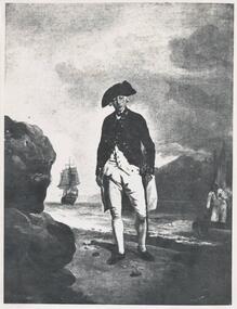 Phillip Island and District Historical Society Inc.
Photograph, Bryant West
... Phillip Island and District Historical Society Inc. phillip-island-and-the-bass-coast One of a collection of over 400 photographs in an album commenced in 1960 and presented to the Phillip Island & Westernport Historical Society by the Shire of Phillip Island local history photography photographs exploration maritime governor arthur phillip arthur phillip john jenner bryant west Vice Admiral Arthur Phillip - first Governor of New South Wales. The man after whom Phillip Island was named. Photograph of a painting by F Wheatley National Portrait Gallery, of Vice Admiral Arthur Phillip standing on beach between water and rocks. ...One of a collection of over 400 photographs in an album commenced in 1960 and presented to the Phillip Island & Westernport Historical Society by the Shire of Phillip IslandPhotograph of a painting by F Wheatley National Portrait Gallery, of Vice Admiral Arthur Phillip standing on beach between water and rocks. Small boat with sailor nearby and ship under sail in background.Vice Admiral Arthur Phillip - first Governor of New South Wales. The man after whom Phillip Island was named.local history, photography, photographs, exploration, maritime, governor arthur phillip, arthur phillip, john jenner, bryant west -
 Bendigo Historical Society Inc.
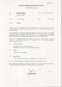
Document - KANGAROO FLAT GOLD MINE COLLECTION: MEMO WESTERN MINING CORPORATION TO D.F. WRIGHT AND R. WRIGHT
... Consent to drilling proposals and exploration licence for : Prince of Wales, Marong portion, bushland reserve and Eaglehawk portion Birds, Crown Land within Shire Spring Gully, area outside water reserve, classified as a Regional Park. ...Consent to drilling proposals and exploration licence for : Prince of Wales, Marong portion, bushland reserve and Eaglehawk portion Birds, Crown Land within Shire Spring Gully, area outside water reserve, classified as a Regional Park. ...Memorandum 29th February 1984 from Western Mining Corporation to T.E. Johanson, subject 'Bendigo'. Consent to drilling proposals and exploration licence for : Prince of Wales, Marong portion, bushland reserve and Eaglehawk portion Birds, Crown Land within Shire Spring Gully, area outside water reserve, classified as a Regional Park. In each of these categories exploration and mining is a permitted use.bendigo, gold mining, drilling proposals, bendigo, goldmining, drilling, t.e. johanson, planning permits, d. evans, r. wright. -
 Bendigo Historical Society Inc.
Letter - KANGAROO FLAT GOLD MINE COLLECTION: ARVI PARBO, WESTERN MINING CORPORATION
... watering Western Mining Corporation. Sir Arvi Parbo J.M. Lalor Daryl McClure Bendigo Trust Letter addressed to Sir Arvi Parbo, Western Mining Corporation, Melbourne, from J.M. Lalor, Exploration ...Letter addressed to Sir Arvi Parbo, Western Mining Corporation, Melbourne, from J.M. Lalor, Exploration Manager, Minerals WMC, regarding support sought by the Bendigo Trust to develop an underground tourist mine at Bendigo. J.H Lalor seeks the support of Western Mining, 'either by contributing money or equipment' to develop the Central Deborah Gold mine as a tourist destination.bendigo, gold mining, central deborah gold mine, bendigo, gold mining, tourism, central deborah gold mine, de-watering, western mining corporation., sir arvi parbo, j.m. lalor, daryl mcclure, bendigo trust -
 Bendigo Historical Society Inc.
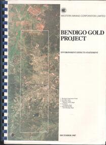
Booklet - Kangaroo Flat Gold Mine Collection: Western Mining Corporation Bendigo Gold Project Environmental Effects Statement December 1987, Western Mining Corporation, Bendigo Office, Western Mining Corporation Limited Bendigo Gold Project Environment Effect Statement December 1987, December 1987
... Contents: historical perspective; Western Mining Corporation Ltd Bendigo activities; project outline, project approvals - controlling factors, elements of the mining project, surface based exploration, underground operations and surface support, mining areas and operations ore and mullock haulage, New Moon area, water management, environmental management. ...Contents: historical perspective; Western Mining Corporation Ltd Bendigo activities; project outline, project approvals - controlling factors, elements of the mining project, surface based exploration, underground operations and surface support, mining areas and operations ore and mullock haulage, New Moon area, water management, environmental management. ...Spiral bound booklet, plastic cover, black plastic binding, On front cover: Western Mining Corporation Bendigo Gold Project, Environment Effects Statement, December 1987. On front page, colour aerial photograph of Bendigo mining areas mentioned in report. Key on front page related to photograph: 1. Woodvale Evaporation Ponds. 2. New Moon area. 3. North New Chum Williams United shaft. 4. Carshalton, Carshalton shaft. 5. South Nell Gwynne, North Bendigo shaft. Contents: historical perspective; Western Mining Corporation Ltd Bendigo activities; project outline, project approvals - controlling factors, elements of the mining project, surface based exploration, underground operations and surface support, mining areas and operations ore and mullock haulage, New Moon area, water management, environmental management. Planning and land use, socio-economic environment, physical environment and biological environment are examined and discussed. bendigo, goldmining, bendigo mining nl, bendigo goldfield, environmental effects statement, bendigo gold project, woodvale evaporation ponds, new moon, north new chum, carshalton, south nell gwynne, western mining corporation -
 Flagstaff Hill Maritime Museum and Village
Book, The Logbooks of The Lady Nelson, 1915
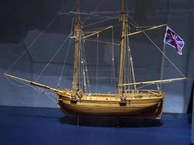
... water. The transcribed Contents, below, summarise the trips of the Lady Nelson during this time. Book’s Content PLUS text of the Chart of ‘Part of Bass Strait’ - Chapter 1: The Lady Nelson built with centreboards. Her voyage to Sydney under James Grant. The first ship to pass through Bass Strait. - Chapter 2: Returns to explore the Strait. Her visits to Jervis Bay and to Western Port in 1801 - Chapter 3: Colonel Paterson and Lieutenant Grant survey Hunter River - Chapter 4: Murray appointed commander of the Lady Nelson. His voyage to Norfolk Island. - Chapter 5: Murray’s exploration...water. The transcribed Contents, below, summarise the trips of the Lady Nelson during this time. Book’s Content PLUS text of the Chart of ‘Part of Bass Strait’ - Chapter 1: The Lady Nelson built with centreboards. Her voyage to Sydney under James Grant. The first ship to pass through Bass Strait. - Chapter 2: Returns to explore the Strait. Her visits to Jervis Bay and to Western Port in 1801 - Chapter 3: Colonel Paterson and Lieutenant Grant survey Hunter River - Chapter 4: Murray appointed commander of the Lady Nelson. His voyage to Norfolk Island. - Chapter 5: Murray’s exploration ...This hardcover book, The logbooks of the 'Lady Nelson' : with the journal of her first commander, Lieutenant James Grant, R.N., by Ida Lee (Mrs Charles Bruce Marriott) was published over 100 years after the Lady Nelson arrived in Australia to navigate and survey this ‘new colony’. Included in the book are sixteen charts and illustrations from the originals in the Admiralty Library, showing the surveyed land and water. The transcribed Contents, below, summarise the trips of the Lady Nelson during this time. Book’s Content PLUS text of the Chart of ‘Part of Bass Strait’ - Chapter 1: The Lady Nelson built with centreboards. Her voyage to Sydney under James Grant. The first ship to pass through Bass Strait. - Chapter 2: Returns to explore the Strait. Her visits to Jervis Bay and to Western Port in 1801 - Chapter 3: Colonel Paterson and Lieutenant Grant survey Hunter River - Chapter 4: Murray appointed commander of the Lady Nelson. His voyage to Norfolk Island. - Chapter 5: Murray’s exploration of Bass Strait. - Chapter 6: Discovery of Port Phillip. - Chapter 7: The Lady Nelson in company with HMS Investigator examines the North-Eastern shores of Australia. - Chapter 8: The French ships in Bass Strait. The founding of Hobart. - Chapter 9: Symons succeeds Curtoys as commander of the Lady Nelson. His voyages to Tasmania, Port Phillip and New Zealand. - Chapter 10: The Lady Nelson in Tasmania. The founding of Port Dalrymple. - Chapter 11: The Estramina is brought to Sydney. The Lady Nelson visits Norfolk Island and Port Dalrymple. - Chapter 12: Tippahee and his four sons are conveyed to New Zealand in the Lady Nelson. - Chapter 13: The Lady Nelson accompanies HMS Tamar to Melville Island. - Chapter 14: The loss of the Lady Nelson Text included with the ‘Chart of Bass Strait’ … “Part of Bass Strait, including the discoveries made by Acting Lieut. J. Murray, commander of His Majesty’s armed surveying vessel Lady Nelson, between November 1801 and March 1802. By command of His Excellency Governor King.” “This chart, which bears Murray’s autograph, shows his explorations of Western Port, Port Phillip and King Island. It should be noted that Flinders Island is named Grand Capuchin. This is one of the charts referred to as "unfortunately missing” in the Historical Records of N.S. Wales, vol. iv. P. 764” The story of the Lady Nelson In 1798 the British Admiralty ordered a cutter of 60 tons to be built along the design of the armed cutter Trial that was developed by Captain John Schanck, with three sliding keels or centreboards that could be individually raised and lowered, for use on the River Thames. The new cutter was to be named Lady Nelson. Philip Gidley King, prior to taking up his appointment as third Governor of the colony of New South Wales, was in England at the time of the Lady Nelson’s fit-out and was aware of the need for such a ship for survey work in the colony in New South Wales. He convinced Captain Schanck, the Commissioner of Transport in England, to construct and rig the Lady Nelson as a brig rather than a cutter, keeping the feature of the three sliding keels, which would be very useful for mapping in shallow waters. The new Lady Nelson was launched at Deptford, England on the River Thames in November 1798, with the official commission to discover and survey the unknown parts of the coast of New Holland (Australia) and establish British sovereignty over the continent. The Lady Nelson sailed from Portsmouth, England on March 1800 under the command of Lieutenant James Grant. She carried an armament of two original and four extra brass carronade carriage guns and set sail as part of a convoy heading to Port Jackson, in New South Wales, New Holland. After a while she continued to sail on her own. Her journey was troubled with problems at times; damaged and broken keels, troublesome crew and leaking topsides between the waterline and the deck due to poor seals. She arrived at the Cape of Good Hope in July and waited for the winter to pass to avoid the strong winds of the ‘Roaring Forties’. While at the Cape, Grant received a despatch to travel to Port Jackson via the newly discovered Bass Strait, rather than the usual route via the tip of Van Diemen’s Land (Tasmania). This also gave him the opportunity to survey the strait on the way. He departed the Cape in October and in December he made his first sighting of New Holland near Mount Gambier in what is now South Australia. A report by Ecclestone in 2012, ‘The Early Charting of Victoria’s Coastline’, mentions that Grant charted and named Capes Banks and Northumberland, and sighted inland hills that he named Mt Gambier and Mt Schanck, the latter after the designer of his ship. Grant then reached the south-western shores of what is now Victoria on 3-4 December 1800, and from Cape Bridgewater he examined the coast eastward to Cape Patton. Although he had not continuously sighted the coast in the vicinity of Port Fairy and Warrnambool, the western part of Victoria became known as Grant’s Land. The Lady Nelson continued eastward and passed through Bass Strait, becoming the first vessel to reach the east coast of New Holland from the west, and arrived at her destination of Port Jackson later in December 1800. Grant, in the Lady Nelson, then left Port Jackson and began survey work. He discovered Port Phillip on Victoria’s coast and explored King Island, he helped establish the first European settlement in Tasmania on the Derwent River, and Port Dalrymple, Newcastle and Port Macquarie. He made several trips from Norfolk Island to Hobart Town. Governor Macquarie sailed on with him to Van Diemen’s Land for a tour of inspection in 1811. Grant helped establish the first settlement on Melville Island in Northern Australia. The Lady Nelson was used to transport cargo, civilians and convicts and to source pigs from Timor. In February 1825 the Lady Nelson sailed again for Timor and never returned. One report said that “Every soul on board, we regret to state, was cruelly massacred, and the hull of the vessel was seen some time after with the name painted on her stern.” The hull was sighted on the island of Babar, which is almost 200 kilometres east of Timor. This particular copy of the book ... This item is from the ‘Pattison Collection’, a collection of books and records that was originally owned by the Warrnambool Mechanics’ Institute, which was founded in Warrnambool in 1853. By 1886 the Warrnambool Mechanics’ Institute (WMI) had grown to have a Library, Museum and Fine Arts Gallery, with a collection of “… choice productions of art, and valuable specimens in almost every branch and many wonderful national curiosities are now to be seen there, including historic relics of the town and district.” It later included a School of Design. Although it was very well patronised, the lack of financial support led the WMI in 1911 to ask the City Council to take it over. In 1935 Ralph Pattison was appointed as City Librarian to establish and organise the Warrnambool Library as it was then called. When the WMI building was pulled down in 1963 a new civic building was erected on the site and the new Warrnambool Library, on behalf of the City Council, took over all the holdings of the WMI. At this time some of the items were separated and identified as the ‘Pattison Collection’, named after Ralph Pattison. Eventually the components of the WMI were distributed from the Warrnambool Library to various places, including the Art Gallery, Historical Society and Flagstaff Hill. Later some were even distributed to other regional branches of Corangamite Regional Library and passed to and fro. It is difficult now to trace just where all of the items have ended up. The books at Flagstaff Hill Maritime Village generally display stamps and markings from Pattison as well as a variety of other institutions including the Mechanics’ Institute itself. RALPH ERIC PATTISON Ralph Eric Pattison was born in Rockhampton, Queensland, in 1891. He married Maude Swan from Warrnambool in 1920 and they set up home in Warrnambool. In 1935 Pattison accepted a position as City Librarian for the Warrnambool City Council. His huge challenge was to make a functional library within two rooms of the Mechanics’ Institute. He tirelessly cleaned, cleared and sorted a disarrayed collection of old books, jars of preserved specimens and other items reserved for exhibition in the city’s museum. He developed and updated the library with a wide variety of books for all tastes, including reference books for students; a difficult task to fulfil during the years following the Depression. He converted all of the lower area of the building into a library, reference room and reading room for members and the public. The books were sorted and stored using a cataloguing and card index system that he had developed himself. He also prepared the upper floor of the building and established the Art Gallery and later the Museum, a place to exhibit the many old relics that had been stored for years for this purpose. One of the treasures he found was a beautiful ancient clock, which he repaired, restored and enjoyed using in his office during the years of his service there. Ralph Pattison was described as “a meticulous gentleman whose punctuality, floorless courtesy and distinctive neat dress were hallmarks of his character, and ‘his’ clock controlled his daily routine, and his opening and closing of the library’s large heavy doors to the minute.” Pattison took leave during 1942 to 1945 to serve in the Royal Australian Navy, Volunteer Reserve as Lieutenant. A few years later he converted one of the Museum’s rooms into a Children’s Library, stocking it with suitable books for the younger generation. This was an instant success. In the 1950’s he had the honour of being appointed to the Victorian Library Board and received more inspiration from the monthly conferences in Melbourne. He was sadly retired in 1959 after over 23 years of service, due to the fact that he had gone over the working age of council officers. However he continued to take a very keen interest in the continual development of the Library until his death in 1969 This book about the logbooks of the Lady Nelson is locally significant for its association with the brig Lady Nelson, in which Lt. James Grant made the first documented European discovery of the area later known as Warrnambool in December 1800. This book is also nationally significant for its association with Grant in the Lady Nelson being the first to sail from west to east through Bass Strait, opening up a shorter, faster route to the colony of Port Jackson rather than going all the way south around Van Diemen’s Land. The book is nationally significant for its contents of the logbooks of the journeys of the Lady Nelson under various commanders and the copies of the charts created from the surveyed information and the new land of Australia was discovered. This book is also significant for its association with the full-size non-sailing replica of the Lady Nelson from Mount Gambier’s visitor centre, which was restored by Flagstaff Hill’s Master Boat Builder in Warrnambool in 2012, and with a ship mode of the Lady Nelson in our Collection The Pattison Collection, along with other items at Flagstaff Hill Maritime Village, was originally part of the Warrnambool Mechanics' Institute’s collection. The Warrnambool Mechanics’ Institute Collection is primarily significant in its totality, rather than for the individual objects it contains. Its contents are highly representative of the development of Mechanics' Institute libraries across Australia, particularly Victoria. A diversity of publications and themes has been amassed, and these provide clues to our understanding of the nature of and changes in the reading habits of Victorians from the 1850s to the middle of the 20th century. The collection also highlights the Warrnambool community’s commitment to the Mechanics’ Institute, reading, literacy and learning in the regions, and proves that access to knowledge was not impeded by distance. These items help to provide a more complete picture of our community’s ideals and aspirations. The Warrnambool Mechanics Institute book collection has historical and social significance for its strong association with the Mechanics Institute movement and the important role it played in the intellectual, cultural and social development of people throughout the latter part of the nineteenth century and the early twentieth century. The collection of books is a rare example of an early lending library and its significance is enhanced by the survival of an original collection of many volumes. The Warrnambool Mechanics' Institute’s publication collection is of both local and state significance. The Logbooks of The Lady Nelson Author: Ida Lee ( Mrs Charles Bruce Marriott) Publisher: Grafton & Co Date: 1915Label on spine with typed text RA 910.994 LEE Inside front cover has a sticker that reads Warrnambool Mechanics Institute and Free Library shipwrecked-coast, flagstaff-hill, warrnambool, flagstaff-hill-maritime-museum, maritime-museum, shipwreck-coast, flagstaff-hill-maritime-village, shipwrecked-artefact, book, warrnambool library, warrnambool mechanics’ institute, warrnambool city librarian, mechanics’ institute library, victorian library board, warrnambool books and records, warrnambool children’s library, great ocean road, the logbooks of the lady nelson, ida lee, mrs charles bruce marriott, captain john schanck, sliding keels or centreboards, lady nelson, british brig hms lady nelson, lieutennant james grant, bass strait discovery, surveying king island and port phillip bay, philip gidley king, survey map -
 Flagstaff Hill Maritime Museum and Village
Craft - Ship Model, H.M.S. Lady Nelson, 1988
... She also successfully chartered much of the Victorian coastline and was heavily involved with the exploration of the Queensland coast with Matthew Flinders; investigated the Hunter River; made numerous visits to New Zealand and Norfolk Island and was involved in the founding of numerous settlements. In comparison to most colonial vessels, the Lady Nelson was technically unique she was fitted with sliding keels, or centreboards, and water-tight trunks reaching to the deck. ...She also successfully chartered much of the Victorian coastline and was heavily involved with the exploration of the Queensland coast with Matthew Flinders; investigated the Hunter River; made numerous visits to New Zealand and Norfolk Island and was involved in the founding of numerous settlements. In comparison to most colonial vessels, the Lady Nelson was technically unique she was fitted with sliding keels, or centreboards, and water-tight trunks reaching to the deck. ...This model of the ship H.M.S. Lady Nelson was researched and built as the vessel Lady Nelson by David Lumsden, a professional ship model builder. His Majesty's Armed Survey Vessel Lady Nelson was commissioned in 1799 to survey the coast of Australia. This vessel was purpose-built before the British Admiralty requested plans for a Schooner for Port Jackson. At the time large parts of the Australian coast were unmapped and Britain had claimed only part of the continent. The British Government were concerned that, in the event of settlers of another European power becoming established in Australia, any future conflict in Europe would lead to a widening of the conflict into the southern hemisphere to the detriment of the trade that Britain sought to develop. Against this background, Lady Nelson was chosen to survey and establish sovereignty over strategic parts of the continent. Lady Nelson left Portsmouth on 18 March 1800 and arrived at Sydney on 16th December 1800 after having been the first vessel to reach the east coast of Australia via the Bass Strait. Before that date, all vessels had sailed around the southern tip of Tasmania to reach their destination. Lady Nelson's survey work commenced shortly after she arrived in Sydney, initially in the Bass Strait area. She was involved in the discovery of Port Phillip, on the coast of Victoria, in establishing settlements on the River Derwent and at Port Dalrymple in Tasmania. She also successfully chartered much of the Victorian coastline and was heavily involved with the exploration of the Queensland coast with Matthew Flinders; investigated the Hunter River; made numerous visits to New Zealand and Norfolk Island and was involved in the founding of numerous settlements. In comparison to most colonial vessels, the Lady Nelson was technically unique she was fitted with sliding keels, or centreboards, and water-tight trunks reaching to the deck. Captain Schank invented these sliding keels that, when raised, reduced her draught to less than six feet. Her life as an exploration vessel ended while accompanying HMS 'Tamar' to Melville Island in 1825, the 'Lady Nelson' was captured and later abandoned by pirates off the island of Babar (Indonesia). This brought the vessel's 25 years of coastal exploration and navigation to a close.The Lady Nelson made was the first British ship to survey of the southern or south-western coast of Australia and traverse the Bass Strait. The vessel holds a special place in Australia's history of exploration as the first to explore and establish settlements in the then-new British colony of Van Diemans Land. The model gives an insight into what life must have been like onboard sailing vessels of the time and Australia's early history of establishment and exploration. This model acts as an important legacy of the full-scale ship which no longer survives. Ship model of the 60 ton British brig HMS Lady Nelson. Timber model of a two-masted brig with rigging but no sails, displaying the British Union Jack flag. The ship is in a glass exhibition display case on metal stand. HMS Lady Nelsonflagstaff hill, warrnambool, shipwrecked coast, flagstaff hill maritime museum, maritime museum, shipwreck coast, flagstaff hill maritime village, great ocean road, by captain john schanck, sliding keels or centreboards, lady nelson, british brig hms lady nelson, david lumsden ship model builder, lieutennant james grant, bass strait discovery, surveying king island and port phillip bay, philip gidley king -
 City of Moorabbin Historical Society (Operating the Box Cottage Museum)
Photograph, postcard "Boiling the Billy" c1900, Early 1900's "Boiling the Billy", c1900
... It is widely accepted that the term "billycan" is derived from the large cans used for transporting bouilli or bully beef on Australia-bound ships or during exploration of the outback, which after use were modified for boiling water over a camp fire. ...It is widely accepted that the term "billycan" is derived from the large cans used for transporting bouilli or bully beef on Australia-bound ships or during exploration of the outback, which after use were modified for boiling water over a camp fire. ...Early 1900's. "Boiling the billy". The term billy or billycan is particularly associated with Australian usage, but is also used in the UK and Ireland. It is widely accepted that the term "billycan" is derived from the large cans used for transporting bouilli or bully beef on Australia-bound ships or during exploration of the outback, which after use were modified for boiling water over a camp fire. Postcards developed out of the complex tradition of nineteenth-century printed calling cards, beginning with the advent of the Cartes-de-Visite in France. In the 1850s, Parisian photographer Andre Adolphe Eugene Disderi invented a photographic process involving egg white, albumen, and silver nitrate to create inexpensive portraits on paper cards. These photographic Cartes-de-Visites were 2 1/2 (75mm) by 4 inches (98mm) and became a popular, collectable form of "visiting cards" world-wide. Photographers would reprint portraits of famous individuals they had taken at their studios or during travel and sell them as collectable cards. Postcards as we know them now first began in 1861 as cards mailed by private post. In the 1870s picture postcards grew in popularity throughout the United States, Britain, Europe, and Japan. Cards were first permitted to have a "Divided Back," with text written on the left half of a dividing line and the address on the right half, beginning in England in 1902. Around 1900 the first postcards made of "Real Photos" rather than artwork began to circulate, aided in by advances in amateur photography equipment by companies such as Kodak. Kodak also introduced postcard paper for photographic development and photography studios began to offer portraits printed as postcards Many local town, countryside, and architectural images were captured during this period by local photographers, then printed and sold as postcards . Advances in amateur photography all contributed to a postcard craze that lasted from 1900 to the First World War. Postcards were the preferred means to send a quick note, whether across town or across a continent.Postcard with a black and white Photograph on the front and a 'Divided Back ' for the message and address. There are seven men surrounding the billy suspended over a camp fire. The ground has a lot of dead branches around. One man is bending down towards the billy. Two men on either side of the camp fire are carrying either a white bag across their shoulders or the fish in their hands. You can see, that there is some steam also coming out of the billy, which means that its hot. Court Post Card. / this space may be used for correspondence. / The address only to be written here.1900's, boiling the billy , postcards, photographers, england, hungary, america, cartes-de-visite, visiting cards, moorabbin, cheltenham, bentleigh, market gardeners, early settlers, pioneers, -
 City of Moorabbin Historical Society (Operating the Box Cottage Museum)
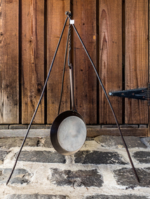
Functional object - Kitchen Equipment, billy holder, c1880
... water; cf. Billabong In Australia. The billy has come to symbolise the spirit of exploration of the outback. ...water; cf. Billabong In Australia. The billy has come to symbolise the spirit of exploration of the outback. ...A billycan, is a lightweight cooking pot which is used on a campfire or a camping stove, particularly associated with Australian usage, but is also used in the UK and Ireland. It is widely accepted that the term "billycan" is derived from the large cans used for transporting bouilli or bully beef on Australia-bound ships or during exploration of the outback, which after use were modified for boiling water over a fire. However there is a suggestion that the word may be associated with the Aboriginal billa (meaning water; cf. Billabong In Australia. The billy has come to symbolise the spirit of exploration of the outback. To boil the billy most often means to make tea. "Billy Tea" is the name of a popular brand of tea long sold in Australian grocers and supermarkets. Billies feature in many of Henry Lawson's stories and poems. Banjo Paterson's most famous of many references to the billy is surely in the first verse and chorus of Waltzing Matilda: "And he sang as he looked at the old billy boiling", which was later changed by the Billy Tea Company to "And he sang as he watched and waited 'til his billy boiled”. Early settlers , market gardeners and blacksmiths would use this portable iron stake to hold their Billies at meal times when out working their fields, travelling for work or pleasure.c1880 A molded, iron tripod stake that would hold a 'Billy can' of water over a camp or kitchen fireearly settlers, pioneers, market gardeners, moorabbin, bentleigh, brighton, cheltenham, tools, blacksmiths -
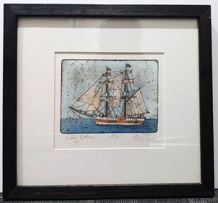 Glenelg Shire Council Cultural Collection
Artwork, other, BRIGIT THOMAS, Lady Nelson, c. 2015
... She was designed with sliding keels (centre boards), a device invented by Captain John Schank of the Royal Navy to allow surveying in rivers and shallow water ways. On completion she was selected for exploration services in the Colony of New South Wales and sailed for Port Jackson on 18 March 1800 under the command of Lieutenant James Grant. ...She was designed with sliding keels (centre boards), a device invented by Captain John Schank of the Royal Navy to allow surveying in rivers and shallow water ways. On completion she was selected for exploration services in the Colony of New South Wales and sailed for Port Jackson on 18 March 1800 under the command of Lieutenant James Grant. ...From - theladynelson.org.au T The original Lady Nelson was built at Deptford, in England, in 1799, for service to the Transport Office on the River Thames. She was designed with sliding keels (centre boards), a device invented by Captain John Schank of the Royal Navy to allow surveying in rivers and shallow water ways. On completion she was selected for exploration services in the Colony of New South Wales and sailed for Port Jackson on 18 March 1800 under the command of Lieutenant James Grant. A brig of 60 tons, she carried a crew comprising the commander, two mates and twelve seaman. As she left the River Thames sailors on nearby ships ridiculed her because of her size and shape, calling her, as she sailed past, 'His Majesty's Tinderbox'. At Portsmouth on the 9th February 1800 she was fitted with four brass carriage guns, three to four pounders, in addition to the two guns already on board. Because of the heavy load she was carrying she was very low in the water, having only two feet nine inches freeboard amidships. The ship finally left Portsmouth on 17th March 1800 as part of an East Indian Convoy. From 1800 to 1825 the Lady Nelson operated around the Australian Coast and fulfilled a variety of roles including exploration, surveying, forming settlements, shifting goods and people around the colonies and capturing pirates. She played pivotal roles in the European settlement of Hobart, Northern Tasmania, Melbourne, Newcastle, Port Macquarie and Northern Territory. Those onboard charted much of Bass Strait, Port Philip, Newcastle, Port Macquarie and (with the Investigator) the coasts of northern New South Wales and southern Queensland. She also has links to other locations around the East Coast such as Trial Bay in NSW and the Mt Gambier area of SA. After 25 years of service while trading on the island of Baba the Lady Nelson was overrun by the islanders, the crew was killed and the ship stripped and later burnt and sunk. A replica of the Lady Nelson was built in the 1980s.Image of a tall ship in sail. The ship is flying both the Aboriginal flag and the Australian Flag. It sails on a calm sea. There are figures on the deck - four in total. The image is mounted on cream board and framed in dark timber. Etching, hand coloured,.Front: 'Lady Nelson A/P BT' - hand written, pencil in between etching and mount Back: Artist's business card glued to back of etching, lower left hand corner:ady nelson, femal artists, female artist, women -
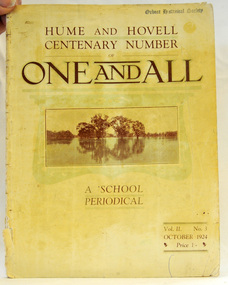 Orbost & District Historical Society
magazine, Clothier & Co, One And All, 1924
... exploration in 1924 a committee was formed to co-ordinate and organise local celebrations along the route from Albury to Corio Bay. A roadside cairn was unveiled near Beechworth. education-Beechworth school-magazine-One-And-All A stapled school magazine with a cream coloured cover. It has an illustration of a river and trees reflected in the water ...This magazine was circulated amongst the pupils, parents, and teachers of the Beechworth Inspectorate, North-East Victoria. This magazine is Vol. 2, no. 3 (Oct. 1924), Hume and Hovell Centenary Number.School magazines were the forerunners of today's school newsletters and were generally published annually. They are contemporary records of the students and staff of the school and usually contain examples of the students' work.This one, published to commemorate the centenary contains information on the Hume and Hovell expedition the purpose of which was to find new grazing land in the south of the colony, and also to find an answer to the mystery of where New South Wales's western rivers flowed. At the centenary of Hume and Hovell exploration in 1924 a committee was formed to co-ordinate and organise local celebrations along the route from Albury to Corio Bay. A roadside cairn was unveiled near Beechworth.A stapled school magazine with a cream coloured cover. It has an illustration of a river and trees reflected in the water on the front. The title, "ONE AND ALL" is at the top in black print. It has " Hume and Hovell Centenary Number" above the title.education-beechworth school-magazine-one-and-all -
 Merri-bek City Council
Photograph - Pigment inkjet print dry mounted to Dibond, Peta Clancy, here merri merri lies 8, 2024
... explorations of place into a single image. here merri merri lies 8, 2024 Here merri merri lies 8 depicts the greenery that thrives along the lake, alongside a layered reflection of the water created from her unique process of cutting and layering reconstructed photographs, symbolic of the hidden and layered histories of Merri Creek. ... -
Tatura Irrigation & Wartime Camps Museum
Book, Emergence of Bioregionalism in the MD Basin, 1993
... explorations, soil erosion, irrigation divsity, land degradation, change, regionalism, conservation, maps of Vic. NSW and Queensland murray darling basin legacies erosion degradation diversity tatura murray river books rural industry Gloosy cover, brown marbled scenes from Berri Irrigation Area Reiver Murray, South Australia on back. Maps, water ...An exploratory essay on he ongoing history of Murray Darling Basin includes legacies, explorations, soil erosion, irrigation divsity, land degradation, change, regionalism, conservation, maps of Vic. NSW and QueenslandGloosy cover, brown marbled scenes from Berri Irrigation Area Reiver Murray, South Australia on back. Maps, water scenes, Pyap Estates on front.murray darling basin, legacies, erosion, degradation, diversity, tatura, murray river, books, rural, industry -
 Mrs Aeneas Gunn Memorial Library
Book, Kegan Paul Trench Trubner and Co, In Australian tropics, 1907
... Mrs Aeneas Gunn Memorial Library via Monbulk RSL, 48 Main Rd Monbulk yarra-valley-and-the-dandenong-ranges Northern Australia - Description and travel Ethnography Early history of N.T. and explorations; Detailed account of intercepting Macassan proas around coast of Arnhem Land whilst author was Sub-Collector of Customs for 14 years; Names of proas and masters, Malay camps & smoke houses along coast & nearby islands; Natives employed by Malays in trepang fishing and collecting tortoiseshell, relationships between Malays and Aborigines; influences (physical & cultural); Habit of exchanging children between tribes (Roper R. & Normanton) for the purpose of learning each others language & customs; Description of native camps at Fort Dundas (1895) shelters, finding of bark water bags, types of canoes used; Platform burial at Daly R.; Sacred burial site on Maria Island; Geographical features, vegetation, climate etc., general ecology, depredations & murders by natives; Cannibalism practiced by Fitzmaurice River tribes. ...Early history of N.T. and explorations; Detailed account of intercepting Macassan proas around coast of Arnhem Land whilst author was Sub-Collector of Customs for 14 years; Names of proas and masters, Malay camps & smoke houses along coast & nearby islands; Natives employed by Malays in trepang fishing and collecting tortoiseshell, relationships between Malays and Aborigines; influences (physical & cultural); Habit of exchanging children between tribes (Roper R. & Normanton) for the purpose of learning each others language & customs; Description of native camps at Fort Dundas (1895) shelters, finding of bark water bags, types of canoes used; Platform burial at Daly R.; Sacred burial site on Maria Island; Geographical features, vegetation, climate etc., general ecology, depredations & murders by natives; Cannibalism practiced by Fitzmaurice River tribes.Ill, maps, p.373.non-fictionEarly history of N.T. and explorations; Detailed account of intercepting Macassan proas around coast of Arnhem Land whilst author was Sub-Collector of Customs for 14 years; Names of proas and masters, Malay camps & smoke houses along coast & nearby islands; Natives employed by Malays in trepang fishing and collecting tortoiseshell, relationships between Malays and Aborigines; influences (physical & cultural); Habit of exchanging children between tribes (Roper R. & Normanton) for the purpose of learning each others language & customs; Description of native camps at Fort Dundas (1895) shelters, finding of bark water bags, types of canoes used; Platform burial at Daly R.; Sacred burial site on Maria Island; Geographical features, vegetation, climate etc., general ecology, depredations & murders by natives; Cannibalism practiced by Fitzmaurice River tribes. northern australia - description and travel, ethnography -
 Bendigo Historical Society Inc.
Document - Kangaroo Flat Gold Mine Collection: New Bendigo Gold Project Newsletters, no date
... exploration drilling - underground and surface drilling and dewatering and safety. Map showing decline development superimposed on street map on back of sheet. June 2002 newsletter, headed 'Environmental Manager Joins the Team' describes the appointment and previous experience of Philipa Varris. The newsletter includes information on water...exploration drilling - underground and surface drilling and dewatering and safety. Map showing decline development superimposed on street map on back of sheet. June 2002 newsletter, headed 'Environmental Manager Joins the Team' describes the appointment and previous experience of Philipa Varris. The newsletter includes information on water ...Three New Bendigo Gold Project newsletters, dated November 2000, June 2002 and April 2003. November 2000 newsletter is headed ' Phase One of Decline Complete' Articles include description of works, rehabilitation work, exploration drilling - underground and surface drilling and dewatering and safety. Map showing decline development superimposed on street map on back of sheet. June 2002 newsletter, headed 'Environmental Manager Joins the Team' describes the appointment and previous experience of Philipa Varris. The newsletter includes information on water treatment plant, new shaft below the surface and provides a personality profile of John Cahill (Frank) the Senior Geologist. April 2003 newsletter, headed 'Bendigo Mining Seeks Site Expansion for Production' provides facts on the Swan Decline, a mine public open day, bird watching at Woodvale, the advisory board and a personality profile on Phil Walklate, project draftsman. A decline development map is provided on bottom right of sheet. bendigo mining n.l., bendigo, mining, gold, kangaroo flat, new bendigo gold project, drilling, rehabilitation, bree darcy, sam mcgowan, marilynh sprague, philipa varris, swan decline -
 Flagstaff Hill Maritime Museum and Village
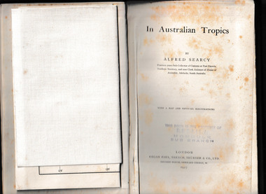
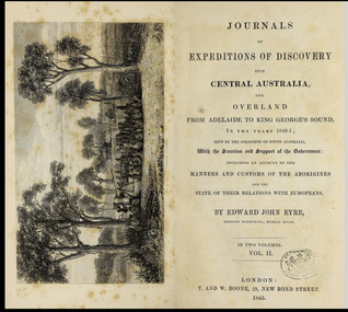
Book - Journal Reference Book/History, Edward John Eyre, Journals of Expeditions of Discovery into Central Australia and Overland From Adelaide to King George Sound. In the years 1840-1 Vol 2, 1845
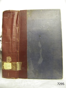
... water, food, and terrain, and Eyre’s observations of the land and its people. The text also includes an account of the manners and customs of Aboriginal peoples and their relations with Europeans, which was part of the original title and purpose of the publication. The work is significant because it became one of the major early written records of inland exploration ...Journals of Expeditions of Discovery into Central Australia was written by Edward John Eyre. It is Eyre’s 1845 account of his 1840–41 exploration journeys from Adelaide into central Australia and then overland to King George’s Sound. The book is published in two volumes and was first issued in 1845. It blends practical expedition reporting with reflection, so it is both a record of exploration and a statement about the colonial understanding of inland Australia.Journals of Expeditions of Discovery into Central Australia Vol 2 Author: Edward John Eyre Publisher: T and W Boone Date: 1845 non-fictionJournals of Expeditions of Discovery into Central Australia was written by Edward John Eyre. It is Eyre’s 1845 account of his 1840–41 exploration journeys from Adelaide into central Australia and then overland to King George’s Sound. The book is published in two volumes and was first issued in 1845. It blends practical expedition reporting with reflection, so it is both a record of exploration and a statement about the colonial understanding of inland Australia. flagstaff hill, warrnambool, shipwrecked coast, flagstaff hill maritime museum, maritime museum, flagstaff hill maritime village, great ocean road, book, warrnambool library, warrnambool mechanics’ institute, mechanics’ institute library, victorian library board, warrnambool books and records, journals of expeditions of discovery into central australia vol 1, edward john eyre -
 Flagstaff Hill Maritime Museum and Village
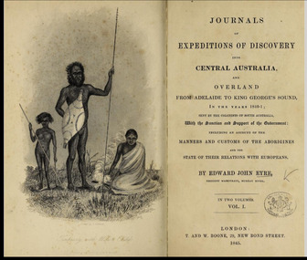
Book - Journal Reference Book/History, Edward John Eyre, Journals of Expeditions of Discovery into Central Australia and Overland From Adelaide to King George Sound. In the years 1840-1 Vol 1, 1845
... water, food, and terrain, and Eyre’s observations of the land and its people. The text also includes an account of the manners and customs of Aboriginal peoples and their relations with Europeans, which was part of the original title and purpose of the publication. The work is significant because it became one of the major early written records of inland exploration ...Journals of Expeditions of Discovery into Central Australia was written by Edward John Eyre. It is Eyre’s 1845 account of his 1840–41 exploration journeys from Adelaide into central Australia and then overland to King George’s Sound. The book is published in two volumes and was first issued in 1845. It blends practical expedition reporting with reflection, so it is both a record of exploration and a statement about the colonial understanding of inland Australia.Journals of Expeditions of Discovery into Central Australia Vol 1 Author: Edward John Eyre Publisher: T and W Boone Date: 1845 non-fictionJournals of Expeditions of Discovery into Central Australia was written by Edward John Eyre. It is Eyre’s 1845 account of his 1840–41 exploration journeys from Adelaide into central Australia and then overland to King George’s Sound. The book is published in two volumes and was first issued in 1845. It blends practical expedition reporting with reflection, so it is both a record of exploration and a statement about the colonial understanding of inland Australia. flagstaff hill, warrnambool, shipwrecked coast, flagstaff hill maritime museum, maritime museum, flagstaff hill maritime village, great ocean road, book, warrnambool library, warrnambool mechanics’ institute, mechanics’ institute library, victorian library board, warrnambool books and records, journals of expeditions of discovery into central australia vol 1, edward john eyre