Showing 6 items matching "water supply bacchus marsh"
-
 Bacchus Marsh & District Historical Society
Map, General Plan for Water Supply Works, Shire of Bacchus Marsh 1887
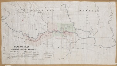
... General Plan for Water Supply Works, Shire of Bacchus Marsh 1887...Water Supply Maps...Water Supply Bacchus Marsh...This plan was part of documentation to support an application for an additional loan of money from the Ministry of Water Supply to the Bacchus Marsh Shire Water Supply Trust. ...A single page paper map showing a general plan for the supply of water in the Bacchus Marsh area.The plan shows the route of the 'Main Channel' near the Werribee River and a proposed route for a Parwan Channel. ...General Plan of Water Supply Works in the Shire of Bacchus Marsh. Accompanying application for 2nd additional Loan. ...This plan was part of documentation to support an application for an additional loan of money from the Ministry of Water Supply to the Bacchus Marsh Shire Water Supply Trust. ...Debate about water supply and its planning and development took place in the Bacchus Marsh region from the 1850s through into the twentieth century. This plan was part of documentation to support an application for an additional loan of money from the Ministry of Water Supply to the Bacchus Marsh Shire Water Supply Trust. The plan includes the route of a proposed water channel in the Parwan area, and other features of water supply infrastructure such as the location of standpipes and gates are also shown on the plan.A single page paper map showing a general plan for the supply of water in the Bacchus Marsh area.The plan shows the route of the 'Main Channel' near the Werribee River and a proposed route for a Parwan Channel. The location of 'Dryden's House' near the Werribee River is also shown and the locations of land held by T. (Tom) Oliver and the Racecourse Reserve in Maddingley. Scale 40 chains to 1 inch. The plan is signed by Bacchus Marsh Shire Engineer, W.E. Standfield. The map is pasted into a bound volume containing 76 maps or plans in total. High resolution digital image stored on BMDHS computer network. General Plan of Water Supply Works in the Shire of Bacchus Marsh. Accompanying application for 2nd additional Loan. Original Waterworks district. Additional area. W.E. Standfield, 30/8/87.water supply, water supply maps, water supply bacchus marsh, irrigation, bacchus marsh victoria maps -
 Bacchus Marsh & District Historical Society
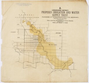
Map, Bacchus Marsh District (A). Proposed Irrigation and Water Supply Trust. Plan shewing boundaries of Trust District
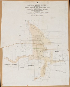
... Water Supply...Bacchus Marsh Irrigation and Water Supply Trust...The Bacchus Marsh Irrigation and Water Supply Trust was formed in 1889. ...Printed paper map of the proposed Bacchus Marsh Irrigation and Water Supply district. Circa 1889. ...Irrigation Water Supply Bacchus Marsh Irrigation and Water Supply Trust Printed paper map of the proposed Bacchus Marsh Irrigation and Water Supply district. ...The 1886 Irrigation Act in Victoria introduced the first legislation in Australia designed to enable the creation of a detailed scheme for agricultural irrigation. Part of the legislation saw the use of government funds for local irrigation projects. These local projects were managed by local irrigation trusts. The Bacchus Marsh Irrigation and Water Supply Trust was formed in 1889. This map depicts the proposed area of the Trust.Printed paper map of the proposed Bacchus Marsh Irrigation and Water Supply district. Circa 1889. Plan showing boundaries of Trust District. The District lies within the Parishes of Korkuperrimul, Merrimu, Parwan and Gorrockburkchap in the Counties of Bourke and Grant. At the top of the map above its title is the letter 'A; in capital lettering. Scale: 40 Chains = 1 inch.irrigation, water supply, bacchus marsh irrigation and water supply trust -
 Bacchus Marsh & District Historical Society
Map, Lerderderg District Proposed Irrigation and Water Supply Trust (B) Plan Showing Proposed Works
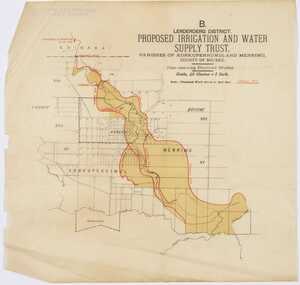
... Bacchus Marsh & District Historical Society Lerderderg Library Main Street Bacchus Marsh The 1886 Irrigation Act in Victoria introduced the first legislation in Australia designed to enable the creation of a detailed scheme for agricultural irrigation. Part of the legislation saw the use of government funds for local irrigation projects. These local projects were managed by local irrigation trusts. The Lerderderg Irrigation and Water Supply ...The 1886 Irrigation Act in Victoria introduced the first legislation in Australia designed to enable the creation of a detailed scheme for agricultural irrigation. Part of the legislation saw the use of government funds for local irrigation projects. These local projects were managed by local irrigation trusts. The Lerderderg Irrigation and Water Supply Trust was formed in 1890. This map depicts the proposed area of the Trust and proposed works such as channels and weirs.Printed paper map of the proposed Lerderderg District Irrigation and Water Supply area showing proposed works. The map scale is 40 chains + 1 inch. The Lerderderg District lies within the Parishes of Korkuperrumul and Merrimu in the County of Bourke. At the top of the map above its title is the letter 'B; in capital lettering. A series of proposed channels are indicated on the map in red lines. A proposed weir site and alternative weir site are also indicated on the map. irrigation, water supply, lerderderg irrigation and water supply trust -
 Bacchus Marsh & District Historical Society
Map, Lerderderg District Proposed Irrigation and Water Supply Trust (C). Plan showing overlap in boundaries of the Trust District
... Bacchus Marsh & District Historical Society Lerderderg Library Main Street Bacchus Marsh The 1886 Irrigation Act in Victoria introduced the first legislation in Australia designed to enable the creation of a detailed scheme for agricultural irrigation. Part of the legislation saw the use of government funds for local irrigation projects. These local projects were managed by local irrigation trusts. The Lerderderg Irrigation and Water Supply ...The 1886 Irrigation Act in Victoria introduced the first legislation in Australia designed to enable the creation of a detailed scheme for agricultural irrigation. Part of the legislation saw the use of government funds for local irrigation projects. These local projects were managed by local irrigation trusts. The Lerderderg Irrigation and Water Supply Trust was formed in 1890. Printed paper map of the proposed Lerderderg District Irrigation and Water Supply. Plan showing overlap in boundaries of Trust District referred to in Mr Burke's report. The Lerderderg District lies within the Parishes of Korkuperrumul and Merrimu in the County of Bourke. At the top of the map above its title is the letter 'C; in capital lettering. A note on this map states: 'Portion of Bacchus MarshUrban District included in area of proposed Trust District shown by hatched shaded lines thus /////////////irrigation, water supply, lerderderg irrigation and water supply trust -
 Bacchus Marsh & District Historical Society
Map, Lerderderg District Proposed Irrigation and Water Supply Trust (A). Plan showing boundaries of Trust District
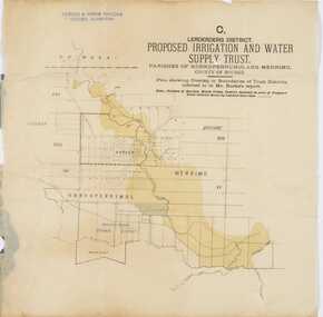
... Bacchus Marsh & District Historical Society Lerderderg Library Main Street Bacchus Marsh The 1886 Irrigation Act in Victoria introduced the first legislation in Australia designed to enable the creation of a detailed scheme for agricultural irrigation. Part of the legislation saw the use of government funds for local irrigation projects. These local projects were managed by local irrigation trusts. The Lerderderg Irrigation and Water Supply ...The 1886 Irrigation Act in Victoria introduced the first legislation in Australia designed to enable the creation of a detailed scheme for agricultural irrigation. Part of the legislation saw the use of government funds for local irrigation projects. These local projects were managed by local irrigation trusts. The Lerderderg Irrigation and Water Supply Trust] was formed in 1890. This map depicts the proposed area of the Trust.Printed paper map of the proposed Lerderderg District Irrigation and Water Supply. Plan showing boundaries of Trust District. The Lerderderg District lies within the Parishes of Korkuperrumul and Merrimu in the County of Bourke. At the top of the map above its title is the letter 'A; in capital lettering. Scale: 40 Chains = 1 inch.irrigation, water supply, lerderderg irrigation and water supply trust -
 Bacchus Marsh & District Historical Society
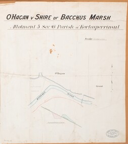
Map, O'Hagan v Shire of Bacchus Marsh, Allotment 5, Sec 16, Parish of Korkuperrimul
... Bacchus Marsh. Features identified on the map are allotment 5, section 16, Parish of Korkuperrimul, a 'cultivation paddock', a section of the Werribee River, the path of a section of a 'Main Channel', and a barrier or filled in section across the Werribee River called 'Lee's Filling'. The O'Hagan is likely to be Patrick O'Hagan, 1829-1914 who arrived in Bacchus Marsh in 1864 and was a prominent citizen and landowner in the area for many years until his death in 1914. Bacchus Marsh Victoria Maps Water Supply ...The purpose for this map being created or the date when it was made has not been established. It appears to be documentation relating to a legal dispute by a landowner named O'Hagan and the Shire of Bacchus Marsh. Features identified on the map are allotment 5, section 16, Parish of Korkuperrimul, a 'cultivation paddock', a section of the Werribee River, the path of a section of a 'Main Channel', and a barrier or filled in section across the Werribee River called 'Lee's Filling'. The O'Hagan is likely to be Patrick O'Hagan, 1829-1914 who arrived in Bacchus Marsh in 1864 and was a prominent citizen and landowner in the area for many years until his death in 1914.Single page map showing allotment 5, section 16 in the Parish of Korkuperrimul, Scale 4 chains to inch. Part of a set of maps which are pasted into a bound volume containing 76 maps or plans in total. High resolution digital image stored on BMDHS computer network. Stamped: Munzt, Bace and Muntz, Civil Engineers and Licensed Surveyors , 388 Collins Streetbacchus marsh victoria maps, water supply structures and establishments, watercourses