Showing 50 items matching "water ways"
-
 Buninyong & District Historical Society
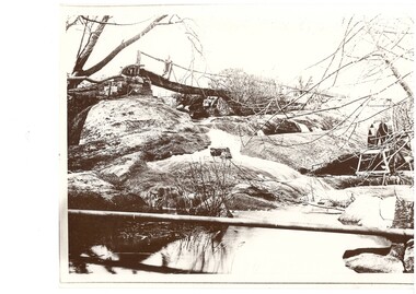
Photograph - Black and white photograph of Archibald Fisken on a bridge on Lal Lal Estate early 1900s, Archibald Fisken on "New Bridge" Lal Lal Estate early 1900s
... ...Water ways...One of a series of photographs featuring the Fisken Family on the Lal Lal Estate The image shows a water system on an early Estate near Buninyong Fisken Family Lal Lal Estate Rural life Water ways Archibald Fisken on the New Bridge Early 1900s, an early bridge over the spillway Lal Lal Park A black and white photograph showing a creek and Arthur Fisken standing on a wooden bridge to the rear over the spillway Archibald Fisken on "New Bridge" Lal Lal Estate early 1900s Photograph Black and white photograph of Archibald Fisken on a bridge on Lal Lal Estate early 1900s ...One of a series of photographs featuring the Fisken Family on the Lal Lal EstateThe image shows a water system on an early Estate near BuninyongA black and white photograph showing a creek and Arthur Fisken standing on a wooden bridge to the rear over the spillwayArchibald Fisken on the New Bridge Early 1900s, an early bridge over the spillway Lal Lal Parkfisken family, lal lal estate, rural life, water ways -
 Bendigo Historical Society Inc.
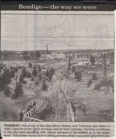
Newspaper - JENNY FOLEY COLLECTION: TRAMWAY
... Sanitary conditions in the city were appalling, with refuse dumped in the streets or in the water ways. The battery was a rock crushing process which separated gold from ore....Sanitary conditions in the city were appalling, with refuse dumped in the streets or in the water ways. The battery was a rock crushing process which separated gold from ore. ...Bendigo Advertiser "The way we were" from 1999. Tramway: this photo of the New Moon Battery and Tramway was taken in 1900. Daily life in the 'good old days' was far from romantic. Sanitary conditions in the city were appalling, with refuse dumped in the streets or in the water ways. The battery was a rock crushing process which separated gold from ore.newspaper, bendigo advertiser, the way we were -
 Bendigo Historical Society Inc.
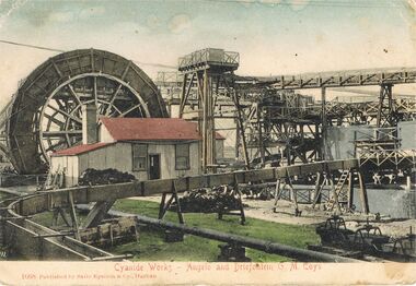
Postcard - POSTCARD: PICTURE OF CYANIDE WORKS
... Coys / published by Salio Epstein & Co Durban / showing race ways and water wheel / circa 1901...Coys / published by Salio Epstein & Co Durban / black and white photo painted in showing race ways and water wheel / circa 1901...Coys / published by Salio Epstein & Co Durban / showing race ways and water wheel / circa 1901 Salio Epstein & Co Durban POSTCARD - picture of Cyanide Works -Agelo and Driefontein G.M. ...POSTCARD - picture of Cyanide Works -Agelo and Driefontein G.M. Coys / published by Salio Epstein & Co Durban / black and white photo painted in showing race ways and water wheel / circa 1901Salio Epstein & Co Durbanpostcard, photograph, various themes, southern africa cyanide works angelo driefontein mine industrial / - picture of cyanide works -agelo and driefontein g.m. coys / published by salio epstein & co durban / showing race ways and water wheel / circa 1901 -
 Warrnambool and District Historical Society Inc.
Sign - Public Works Office
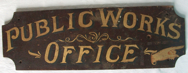
... It had many different reponsibilities and roles from building government accommodation and fit out of buildings, licences for unused roads and water ways, main roads and bridges, ports and harbour,and water supplies. ...It had many different reponsibilities and roles from building government accommodation and fit out of buildings, licences for unused roads and water ways, main roads and bridges, ports and harbour,and water supplies. ...This sign points has two different messages. The first states Public Works Office, which was operational in Victoria between 1855 and 1987 dealt with many aspects of the states infrastructure. It had many different reponsibilities and roles from building government accommodation and fit out of buildings, licences for unused roads and water ways, main roads and bridges, ports and harbour,and water supplies. Much of this work was managed through local offices such as the one at Warrnambool. The sign on the reverse which states Witnesses Waiting Room relates to the court house which is where this sign originated.The Warrnambool court house was built in 1870-71 by the Victorian Public Works department and it is possible that this sign relates to that period.It is one of a number of public buildings built in the period 1870-1890 including the Police station and stables and police quarters, the Post Office and drill Hall , all in the same vicinity. This building reflects the growth of the town and also the importance it held at the time from a state level. The building while no longer used as a court house is a building of significance to Warrnambool as well as to the state of Victoria, being one of six around the state which were built in free classical style. This sign denotes the waiting room for witnesses which was situated on the western side of the building.A tangible link which provides historical and social significance to Warrnambool.Rectangular wooden sign with rounded corners. There is text on both sides painted in gold paint with shadow in black. One side is a darker brown stain . There are screw holes in each corner.and one hole on left middle of sign. Rounded edge on one side.Side 1:Witnesses Waiting Room Side 2:Public Works Office.warrnambool, warrnambool court house, public works department warrnambool -
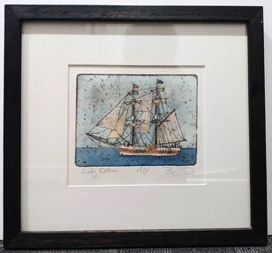 Glenelg Shire Council Cultural Collection
Artwork, other, BRIGIT THOMAS, Lady Nelson, c. 2015
... She was designed with sliding keels (centre boards), a device invented by Captain John Schank of the Royal Navy to allow surveying in rivers and shallow water ways. On completion she was selected for exploration services in the Colony of New South Wales and sailed for Port Jackson on 18 March 1800 under the command of Lieutenant James Grant. ...She was designed with sliding keels (centre boards), a device invented by Captain John Schank of the Royal Navy to allow surveying in rivers and shallow water ways. On completion she was selected for exploration services in the Colony of New South Wales and sailed for Port Jackson on 18 March 1800 under the command of Lieutenant James Grant. ...From - theladynelson.org.au T The original Lady Nelson was built at Deptford, in England, in 1799, for service to the Transport Office on the River Thames. She was designed with sliding keels (centre boards), a device invented by Captain John Schank of the Royal Navy to allow surveying in rivers and shallow water ways. On completion she was selected for exploration services in the Colony of New South Wales and sailed for Port Jackson on 18 March 1800 under the command of Lieutenant James Grant. A brig of 60 tons, she carried a crew comprising the commander, two mates and twelve seaman. As she left the River Thames sailors on nearby ships ridiculed her because of her size and shape, calling her, as she sailed past, 'His Majesty's Tinderbox'. At Portsmouth on the 9th February 1800 she was fitted with four brass carriage guns, three to four pounders, in addition to the two guns already on board. Because of the heavy load she was carrying she was very low in the water, having only two feet nine inches freeboard amidships. The ship finally left Portsmouth on 17th March 1800 as part of an East Indian Convoy. From 1800 to 1825 the Lady Nelson operated around the Australian Coast and fulfilled a variety of roles including exploration, surveying, forming settlements, shifting goods and people around the colonies and capturing pirates. She played pivotal roles in the European settlement of Hobart, Northern Tasmania, Melbourne, Newcastle, Port Macquarie and Northern Territory. Those onboard charted much of Bass Strait, Port Philip, Newcastle, Port Macquarie and (with the Investigator) the coasts of northern New South Wales and southern Queensland. She also has links to other locations around the East Coast such as Trial Bay in NSW and the Mt Gambier area of SA. After 25 years of service while trading on the island of Baba the Lady Nelson was overrun by the islanders, the crew was killed and the ship stripped and later burnt and sunk. A replica of the Lady Nelson was built in the 1980s.Image of a tall ship in sail. The ship is flying both the Aboriginal flag and the Australian Flag. It sails on a calm sea. There are figures on the deck - four in total. The image is mounted on cream board and framed in dark timber. Etching, hand coloured,.Front: 'Lady Nelson A/P BT' - hand written, pencil in between etching and mount Back: Artist's business card glued to back of etching, lower left hand corner:ady nelson, femal artists, female artist, women -
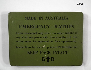 Bendigo Military Museum
Container - EMERGENCY RATION, Department of Defence
... The Insructions for use contain items, “Fruit ration & milk tablets to be eaten as is, the meat & veg ration can be eaten either of 3 ways, as is, add 3 times its bulk of water or moisten and fry as a rissoles”...Bendigo Military Museum 37 - 39 Pall Mall Bendigo goldfields The Insructions for use contain items, “Fruit ration & milk tablets to be eaten as is, the meat & veg ration can be eaten either of 3 ways, as is, add 3 times its bulk of water or moisten and fry as a rissoles” Emergency ration containers On lid,” Made in Australia, Emergency Ration, keep pack intact, D (arrow up) D” Tin, green colour, rectangular shape, lid has print in black on the front, inside has “Instructions for use” on the lid, the container has no print or other on. ...The Insructions for use contain items, “Fruit ration & milk tablets to be eaten as is, the meat & veg ration can be eaten either of 3 ways, as is, add 3 times its bulk of water or moisten and fry as a rissoles”Tin, green colour, rectangular shape, lid has print in black on the front, inside has “Instructions for use” on the lid, the container has no print or other on.On lid,” Made in Australia, Emergency Ration, keep pack intact, D (arrow up) D”emergency ration, containers -
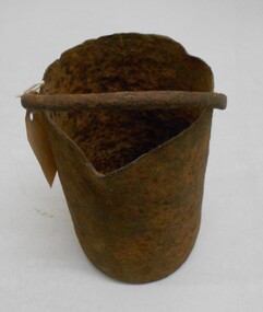 Bendigo Historical Society Inc.
Tool - MERCURY BUCKET
... ways to amalgamate gold... with each mill or battery operator having their preferred method depending on the nature of the ore. By the late 1850s the most common way of crushing goldbearing quartz ores or consolidated alluvial cements was in a stamp battery. The battery featured heavy iron stamp heads held in a frame... with each head often weighing up to 500 pounds (226 kg) or more (see MSV 1880... page 45) (Birrell 2005). Stamp heads were lifted and dropped by a rotating overhead cam shaft driven by a steam engine or water...ways to amalgamate gold with each mill or battery operator having their preferred method depending on the nature of the ore. By the late 1850s the most common way of crushing goldbearing quartz ores or consolidated alluvial cements was in a stamp battery. The battery featured heavy iron stamp heads held in a frame with each head often weighing up to 500 pounds (226 kg) or more (see MSV 1880 page 45) (Birrell 2005). Stamp heads were lifted and dropped by a rotating overhead cam shaft driven by a steam engine or water ...Cast iron mercury bucket, used to hold mercury, potentially in the process of recovering minute pieces of gold mixed in soil and sediments. See research page for description of one process of using mercury to extract gold.gold mines, mining equipment, mercury bucket, miners used mercury in a number of ways to amalgamate gold, with each mill or battery operator having their preferred method depending on the nature of the ore. by the late 1850s the most common way of crushing goldbearing quartz ores or consolidated alluvial cements was in a stamp battery. the battery featured heavy iron stamp heads held in a frame, with each head often weighing up to 500 pounds (226 kg) or more (see msv 1880, page 45) (birrell 2005). stamp heads were lifted and dropped by a rotating overhead cam shaft driven by a steam engine or water wheel. ore was fed into a large cast-iron battery box, mixed with a steady stream of water, and pulverised by the stamp heads. in some batteries, mercury was placed in the base of the boxes to amalgamate with freed gold. the violent agitation of the mercury in the mortar box, however, could cause the mercury to break into myriad tiny globules that were carried away by the water with the tailings, thus losing a certain amount of gold in the process (thompson 1867; ritchie & hooker 1997). the water and sand slurry was splashed by the falling stamps from the box through fine mesh screens and onto inclined wooden tables below the mortar box (figure 2). the tables were covered with copper sheets or plates coated with mercury, which caught and amalgamated with a portion of the gold. the grey putty-like amalgam was periodically scraped off the sheets and retorted in a furnace to collect the gold and recover the mercury for reuse. mercury was inevitably lost from the plates, while poor maintenance resulted in further losses of gold and mercury in the tailings. mercury use and loss from gold mining in 19th century victoria. peter davies1, susan lawrence, and jodi turnbull, department of archaeology and history, la trobe university. -
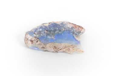 The Beechworth Burke Museum
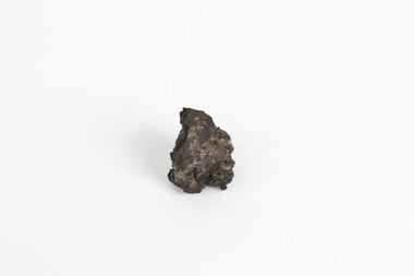
Geological specimen - Precious Opal
... Common Opal is formed from silica-rich water circulating through rocks near the Earth’s surface. It consists of minute spheres of silica arranged in different ways. ...Common Opal is formed from silica-rich water circulating through rocks near the Earth’s surface. It consists of minute spheres of silica arranged in different ways. ...In Australia, precious opal is found in Cretaceous age sandstones and mudstones. These sedimentary rocks were deeply weathered and this weathering released silica into the groundwater.Australia is the only part of the world where opalised animal and plant fossils have been found. Opal artefacts several thousands of years old have been discovered in East Africa. As early as 250 BC the Romans prized opals, thought to have come from mines in Eastern Europe, the ancient world's main source of opals. There are many aboriginal dreamtime stories that feature opal. Australian opals discovered during the late 1800's found little favour with European markets but their commercial value increased in the 1900's and in 1932 Australia took over as the major producer of opals in the world and remains the largest producer to this day. Opal is found around the world (Brazil, Mexico, Honduras and the western US) however Australia produces 95% of the world's precious opal and it is our official national gemstone. Opal was first mined commercially at Listowel Downs in Queensland in 1875 and later at White Cliffs in NSW. Today, Coober Pedy (SA) is the main producer of white opal, though in recent years this field has expanded and all types of opals are found. Other centres in SA include Andamooka and Mintabe. Lightning Ridge (NSW) is renowned for black opal and formerly White Cliffs was a large producer of high quality opal. Boulder opals (opals in concretionary ironstone) are mined in Queensland from numerous localities in a zone extending from the Eulo and Cunnamulla district in the south and northwest for a distance of over 700 km to Kynuna in the north. The towns of Quilpie, Yowah and Winton are the main opal mining and wholesale centres. Opals are considered gemstones and have been used in jewellery for thousands of years.Throughout much of history, opals were actually believed to be good luck. The Romans thought that opals were one of the luckiest gemstones and a symbol of hope. In the Middle Ages, opals were believed to be bestowed with all the positive properties of coloured gemstones due to its rainbow-like play of colour. Finally, there is a superstition that you should not wear an opal unless it is your birthstone otherwise misfortune will befall you. This, of course, is far-fetched, but the notion could have been promoted in the late 19th and early 20th Centuries by diamond traders who were trying to increase sales of diamonds and deter people from buying opals. Possibly related to this is the thought that you should set opal jewellery with diamonds as their powers of good fortune will override any negativity held by the opal. The great majority of opal does not show play of colour and is called common opal or potch however this is not the case with a precious opal. Opal is a precious gemstone, like rubies, emeralds or diamonds. Opal is rare, and it is expensive to prospect and mine for.Silica is one of the most common minerals on the planet, but precious opal is very rare – far more rare than diamonds. Precious opal is rare because the natural processes that create it rarely occur.Most (at least 95%) of the opal found by miners is common opal without gem colour. In Australia we call it potch. It can be white, grey, black or amber coloured. Even when a miner finds gem-coloured opal, most of it can’t be cut into gemstones because it’s too thin, or sandy. This specimen is part of a larger collection of geological and mineral specimens collected from around Australia (and some parts of the world) and donated to the Burke Museum between 1868-1880. A large percentage of these specimens were collected in Victoria as part of the Geological Survey of Victoria that begun in 1852 (in response to the Gold Rush) to study and map the geology of Victoria. Collecting geological specimens was an important part of mapping and understanding the scientific makeup of the earth. Many of these specimens were sent to research and collecting organisations across Australia, including the Burke Museum, to educate and encourage further study.It is not known where this opal originated, except that it is probably from Victoria, as it has been recorded from many localities in the State. Common Opal is formed from silica-rich water circulating through rocks near the Earth’s surface. It consists of minute spheres of silica arranged in different ways. In common opal, the spheres are of different sizes and randomly arranged, unlike in precious opal where the spheres are of similar size and uniformly arranged in three dimensions. These differences account for common opal generally being translucent to opaque and without the play of colours, or opalescence, displayed by precious opal. Common opal is found in many localities and different geological environments throughout Australia and the world. Precious opal requires special conditions to form and is much less common. Australia produces most to the world’s precious opal. burke museum, beechworth, indigo shire, beechworth museum, geological, geological specimen, precious opal, opal, brazil, mexico, honduras, queensland, coober pedy, gemstones, jewellery, play-of-colour, light blue -
 The Beechworth Burke Museum
Geological specimen - Native (metallic) copper, Unknown
... ways. Copper is an invaluable recourse used in daily life, used in most electrical appliances as it is a great conductor of heat and electricity, as well as being soft and malleable, making it easy to bend and mould into delicate sheets and wires. Copper does not corrode and is therefore used in the production of water ...This specimen is a native copper specimen that is metallic. Copper is typically found in the earth's crust and is often found alongside other metals such as gold, zinc, lead and silver which all belong to the same group which is the Copper/Gold group. Copper is most commonly formed from large masses of molten lava rock which has solidified in the earth's crust and over time though different sizes and speeds of crystal growth has turned into large amounts of copper, stored in porphyry copper deposits. Copper has a distinctive colour, yet can sometime appear blue and greenish which is often caused by oxidisation or a mixture of copper and other metals. This specific specimen was recovered from Moonta, South Australia. The Moonta Mining Company was established in 1861, after a Shepard in the area noticed traces of copper. This lead to a rush in the copper mining industry which was relatively young in Australia at the time, making Moonta Mining Company one of the richest in Australia. By the 1860's, South Australia had been nicknamed the "Copper Kingdom" due to its vast amount of Large copper mines and resources. As of 2016, Australia was the second largest producer of Copper internationally, following behind Chile in first place. This copper specimen is significant historically and scientifically as it is such an important metal commonly used throughout the world in various ways. Copper is an invaluable recourse used in daily life, used in most electrical appliances as it is a great conductor of heat and electricity, as well as being soft and malleable, making it easy to bend and mould into delicate sheets and wires. Copper does not corrode and is therefore used in the production of water pipes among countless other significant necessities that are often overlooked in our society. Historically, Copper holds great significance as it was the first metal used by humans. It was discovered roughly 9000 years ago and was utilised by the Neolithic Man who learnt that heating the metal made it more malleable, thus tools and utensils were made which were far superior to the previous stone tools used by humans. This history and its connection to the current and ongoing relationship between humans and copper must be preserved and highlighted as it is integral to the history of all humankind. A small, palm-sized solid native copper mineral specimen with shades of browns, black and rustic tones throughout the specimen.NATIVE (metalic) COPPER / Locality: Moonta, South Australiabeechworth, burke museum, geological specimen, native specimen, geological, mineral, mineralogy, indigo shire, beechworth museum, copper, copper ore -
 Eltham District Historical Society Inc
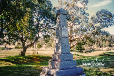
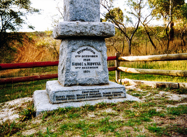
Photograph, Hume and Hovell Monument, Broadford, Autumn Excursion, Hume and Hovell's 1824 expedition, 26 May 1996, 26/05/1996
... Our next river crossing was at Werribee, "in a vast treeless plain", then we drove on by-ways no coach had previously travelled, to find "an immense sheet of water" salty Corio Bay, off-course to the west. ...Our next river crossing was at Werribee, "in a vast treeless plain", then we drove on by-ways no coach had previously travelled, to find "an immense sheet of water" salty Corio Bay, off-course to the west. ...[article by Bettina Woodburn in EDHS Newsletter No. 109, July 1996:] ON THE TRAIL OF HUME AND HOVELL - REPORT ON THE AUTUMN EXCURSION - On a green and fresh morning (Sunday 26th May 1996) the Cobb and Co coach (driven by the most obliging Peter Tampion) set off in a north easterly direction from Eltham to connect with Hume and Hovell's route on their 1824 explorations of central Victoria. The Society would follow a series of monuments erected for the 1924 centenary of the expedition from King Parrot Creek (Tuesday 7th December 1824), through Strath Creek, over Sunday Creek (Sunday 12th December 1824) at Broadford, Tullamarine, St Albans, Deer Park, through Werribee, skirting east of the You Yangs to Lara and Avalon Beach. Because their distance-measuring wheel had broken and a one degree mistake was made in calculations, the two leaders of the original group of six convict-companions arrived at Corio Bay, instead of the expected Western Port, discovered earlier by Flinders. From below Mt. Disappointment (Hume and Hovell's difficulties in "scrambling over brush and rock", "leeches in forest, as well as no water", "cutting grass 4-5 ft. high", dreadful scrub", "devil flies") we took an easier route, saw the Strath Creek memorial in ground fog and a wonderful "field of dreams", the Hume-Hovell privately owned cricket ground with its white picket boundary fence. Now, after a steep climb, in sunshine under gums we stretched and viewed magnificent rolling hills and fog-filled valleys - not "smoke from Aborigines' bush fires". After morning tea at Broadford we followed the Sunday Creek valley beside the Hume Freeway, passed the Wallan Wallan Rest Area (more appropriately Hume and Hovell Rest Area) to tum right at Beveridge. In Gellibrand Hill Park, near the headwaters of the Moonee Ponds Creek, we experienced the landscape the first European settlers saw - huge river red gums and rolling pastures. The gardens and sheltered courtyard of the 1840s, timber, brought from .....[?] prefabricated Woodlands Homestead, provided a pleasant lunch stop. We enjoyed a private tour, panoramic views over Melbourne and surroundings and the excitement of arriving and departing aircraft. Our next river crossing was at Werribee, "in a vast treeless plain", then we drove on by-ways no coach had previously travelled, to find "an immense sheet of water" salty Corio Bay, off-course to the west. In late afternoon of a super, calm, late autumn day we headed homewards. Back at Eltham we were rather surprised to find that we had travelled a total of 347 km. Thanks again to Russell Yeoman for his research and organization. What a wonderful day! Colour photographactivities, broadford, hume and hovell, monument -
 Eltham District Historical Society Inc
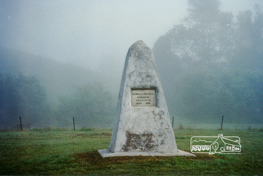
Photograph, Strath Creek, Autumn Excursion, Hume and Hovell's 1824 expedition, 26 May 1996, 26/05/1996
... Our next river crossing was at Werribee, "in a vast treeless plain", then we drove on by-ways no coach had previously travelled, to find "an immense sheet of water" salty Corio Bay, off-course to the west. ...Our next river crossing was at Werribee, "in a vast treeless plain", then we drove on by-ways no coach had previously travelled, to find "an immense sheet of water" salty Corio Bay, off-course to the west. ...[article by Bettina Woodburn in EDHS Newsletter No. 109, July 1996:] ON THE TRAIL OF HUME AND HOVELL - REPORT ON THE AUTUMN EXCURSION - On a green and fresh morning (Sunday 26th May 1996) the Cobb and Co coach (driven by the most obliging Peter Tampion) set off in a north easterly direction from Eltham to connect with Hume and Hovell's route on their 1824 explorations of central Victoria. The Society would follow a series of monuments erected for the 1924 centenary of the expedition from King Parrot Creek (Tuesday 7th December 1824), through Strath Creek, over Sunday Creek (Sunday 12th December 1824) at Broadford, Tullamarine, St Albans, Deer Park, through Werribee, skirting east of the You Yangs to Lara and Avalon Beach. Because their distance-measuring wheel had broken and a one degree mistake was made in calculations, the two leaders of the original group of six convict-companions arrived at Corio Bay, instead of the expected Western Port, discovered earlier by Flinders. From below Mt. Disappointment (Hume and Hovell's difficulties in "scrambling over brush and rock", "leeches in forest, as well as no water", "cutting grass 4-5 ft. high", dreadful scrub", "devil flies") we took an easier route, saw the Strath Creek memorial in ground fog and a wonderful "field of dreams", the Hume-Hovell privately owned cricket ground with its white picket boundary fence. Now, after a steep climb, in sunshine under gums we stretched and viewed magnificent rolling hills and fog-filled valleys - not "smoke from Aborigines' bush fires". After morning tea at Broadford we followed the Sunday Creek valley beside the Hume Freeway, passed the Wallan Wallan Rest Area (more appropriately Hume and Hovell Rest Area) to tum right at Beveridge. In Gellibrand Hill Park, near the headwaters of the Moonee Ponds Creek, we experienced the landscape the first European settlers saw - huge river red gums and rolling pastures. The gardens and sheltered courtyard of the 1840s, timber, brought from .....[?] prefabricated Woodlands Homestead, provided a pleasant lunch stop. We enjoyed a private tour, panoramic views over Melbourne and surroundings and the excitement of arriving and departing aircraft. Our next river crossing was at Werribee, "in a vast treeless plain", then we drove on by-ways no coach had previously travelled, to find "an immense sheet of water" salty Corio Bay, off-course to the west. In late afternoon of a super, calm, late autumn day we headed homewards. Back at Eltham we were rather surprised to find that we had travelled a total of 347 km. Thanks again to Russell Yeoman for his research and organization. What a wonderful day! Colour photographactivities, monument, hume and hovell, murchison valley, strath creek -
 Eltham District Historical Society Inc
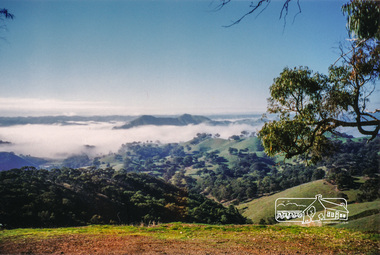
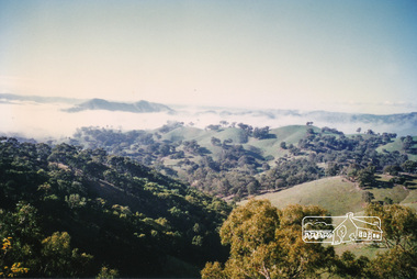
Photograph, Murchison Gap viewed from Strath Creek, Autumn Excursion, Hume and Hovell's 1824 expedition, 26 May 1996, 26/05/1996
... Our next river crossing was at Werribee, "in a vast treeless plain", then we drove on by-ways no coach had previously travelled, to find "an immense sheet of water" salty Corio Bay, off-course to the west. ...Our next river crossing was at Werribee, "in a vast treeless plain", then we drove on by-ways no coach had previously travelled, to find "an immense sheet of water" salty Corio Bay, off-course to the west. ...[article by Bettina Woodburn in EDHS Newsletter No. 109, July 1996:] ON THE TRAIL OF HUME AND HOVELL - REPORT ON THE AUTUMN EXCURSION - On a green and fresh morning (Sunday 26th May 1996) the Cobb and Co coach (driven by the most obliging Peter Tampion) set off in a north easterly direction from Eltham to connect with Hume and Hovell's route on their 1824 explorations of central Victoria. The Society would follow a series of monuments erected for the 1924 centenary of the expedition from King Parrot Creek (Tuesday 7th December 1824), through Strath Creek, over Sunday Creek (Sunday 12th December 1824) at Broadford, Tullamarine, St Albans, Deer Park, through Werribee, skirting east of the You Yangs to Lara and Avalon Beach. Because their distance-measuring wheel had broken and a one degree mistake was made in calculations, the two leaders of the original group of six convict-companions arrived at Corio Bay, instead of the expected Western Port, discovered earlier by Flinders. From below Mt. Disappointment (Hume and Hovell's difficulties in "scrambling over brush and rock", "leeches in forest, as well as no water", "cutting grass 4-5 ft. high", dreadful scrub", "devil flies") we took an easier route, saw the Strath Creek memorial in ground fog and a wonderful "field of dreams", the Hume-Hovell privately owned cricket ground with its white picket boundary fence. Now, after a steep climb, in sunshine under gums we stretched and viewed magnificent rolling hills and fog-filled valleys - not "smoke from Aborigines' bush fires". After morning tea at Broadford we followed the Sunday Creek valley beside the Hume Freeway, passed the Wallan Wallan Rest Area (more appropriately Hume and Hovell Rest Area) to tum right at Beveridge. In Gellibrand Hill Park, near the headwaters of the Moonee Ponds Creek, we experienced the landscape the first European settlers saw - huge river red gums and rolling pastures. The gardens and sheltered courtyard of the 1840s, timber, brought from .....[?] prefabricated Woodlands Homestead, provided a pleasant lunch stop. We enjoyed a private tour, panoramic views over Melbourne and surroundings and the excitement of arriving and departing aircraft. Our next river crossing was at Werribee, "in a vast treeless plain", then we drove on by-ways no coach had previously travelled, to find "an immense sheet of water" salty Corio Bay, off-course to the west. In late afternoon of a super, calm, late autumn day we headed homewards. Back at Eltham we were rather surprised to find that we had travelled a total of 347 km. Thanks again to Russell Yeoman for his research and organization. What a wonderful day! Colour photographactivities, hume and hovell, murchison valley, murchison gap, strath creek -
 Eltham District Historical Society Inc
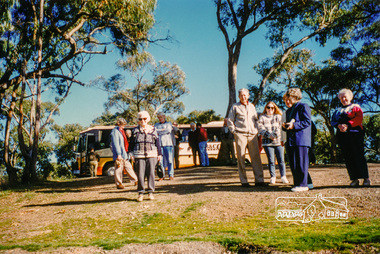
Photograph, Autumn Excursion, Hume and Hovell's 1824 expedition, 26 May 1996, 26/05/1996
... Our next river crossing was at Werribee, "in a vast treeless plain", then we drove on by-ways no coach had previously travelled, to find "an immense sheet of water" salty Corio Bay, off-course to the west. ...Our next river crossing was at Werribee, "in a vast treeless plain", then we drove on by-ways no coach had previously travelled, to find "an immense sheet of water" salty Corio Bay, off-course to the west. ...[article by Bettina Woodburn in EDHS Newsletter No. 109, July 1996:] ON THE TRAIL OF HUME AND HOVELL - REPORT ON THE AUTUMN EXCURSION - On a green and fresh morning (Sunday 26th May 1996) the Cobb and Co coach (driven by the most obliging Peter Tampion) set off in a north easterly direction from Eltham to connect with Hume and Hovell's route on their 1824 explorations of central Victoria. The Society would follow a series of monuments erected for the 1924 centenary of the expedition from King Parrot Creek (Tuesday 7th December 1824), through Strath Creek, over Sunday Creek (Sunday 12th December 1824) at Broadford, Tullamarine, St Albans, Deer Park, through Werribee, skirting east of the You Yangs to Lara and Avalon Beach. Because their distance-measuring wheel had broken and a one degree mistake was made in calculations, the two leaders of the original group of six convict-companions arrived at Corio Bay, instead of the expected Western Port, discovered earlier by Flinders. From below Mt. Disappointment (Hume and Hovell's difficulties in "scrambling over brush and rock", "leeches in forest, as well as no water", "cutting grass 4-5 ft. high", dreadful scrub", "devil flies") we took an easier route, saw the Strath Creek memorial in ground fog and a wonderful "field of dreams", the Hume-Hovell privately owned cricket ground with its white picket boundary fence. Now, after a steep climb, in sunshine under gums we stretched and viewed magnificent rolling hills and fog-filled valleys - not "smoke from Aborigines' bush fires". After morning tea at Broadford we followed the Sunday Creek valley beside the Hume Freeway, passed the Wallan Wallan Rest Area (more appropriately Hume and Hovell Rest Area) to tum right at Beveridge. In Gellibrand Hill Park, near the headwaters of the Moonee Ponds Creek, we experienced the landscape the first European settlers saw - huge river red gums and rolling pastures. The gardens and sheltered courtyard of the 1840s, timber, brought from .....[?] prefabricated Woodlands Homestead, provided a pleasant lunch stop. We enjoyed a private tour, panoramic views over Melbourne and surroundings and the excitement of arriving and departing aircraft. Our next river crossing was at Werribee, "in a vast treeless plain", then we drove on by-ways no coach had previously travelled, to find "an immense sheet of water" salty Corio Bay, off-course to the west. In late afternoon of a super, calm, late autumn day we headed homewards. Back at Eltham we were rather surprised to find that we had travelled a total of 347 km. Thanks again to Russell Yeoman for his research and organization. What a wonderful day! Colour photographactivities, hume and hovell -
 Eltham District Historical Society Inc
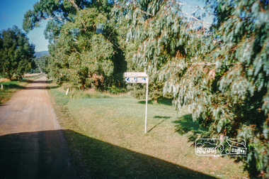
Photograph, Sign to Hume and Hovell Cricket Ground, at Allandale Road, Strath Creek, Autumn Excursion, Hume and Hovell's 1824 expedition, 26 May 1996, 26/05/1996
... Our next river crossing was at Werribee, "in a vast treeless plain", then we drove on by-ways no coach had previously travelled, to find "an immense sheet of water" salty Corio Bay, off-course to the west. ...Our next river crossing was at Werribee, "in a vast treeless plain", then we drove on by-ways no coach had previously travelled, to find "an immense sheet of water" salty Corio Bay, off-course to the west. ...[article by Bettina Woodburn in EDHS Newsletter No. 109, July 1996:] ON THE TRAIL OF HUME AND HOVELL - REPORT ON THE AUTUMN EXCURSION - On a green and fresh morning (Sunday 26th May 1996) the Cobb and Co coach (driven by the most obliging Peter Tampion) set off in a north easterly direction from Eltham to connect with Hume and Hovell's route on their 1824 explorations of central Victoria. The Society would follow a series of monuments erected for the 1924 centenary of the expedition from King Parrot Creek (Tuesday 7th December 1824), through Strath Creek, over Sunday Creek (Sunday 12th December 1824) at Broadford, Tullamarine, St Albans, Deer Park, through Werribee, skirting east of the You Yangs to Lara and Avalon Beach. Because their distance-measuring wheel had broken and a one degree mistake was made in calculations, the two leaders of the original group of six convict-companions arrived at Corio Bay, instead of the expected Western Port, discovered earlier by Flinders. From below Mt. Disappointment (Hume and Hovell's difficulties in "scrambling over brush and rock", "leeches in forest, as well as no water", "cutting grass 4-5 ft. high", dreadful scrub", "devil flies") we took an easier route, saw the Strath Creek memorial in ground fog and a wonderful "field of dreams", the Hume-Hovell privately owned cricket ground with its white picket boundary fence. Now, after a steep climb, in sunshine under gums we stretched and viewed magnificent rolling hills and fog-filled valleys - not "smoke from Aborigines' bush fires". After morning tea at Broadford we followed the Sunday Creek valley beside the Hume Freeway, passed the Wallan Wallan Rest Area (more appropriately Hume and Hovell Rest Area) to tum right at Beveridge. In Gellibrand Hill Park, near the headwaters of the Moonee Ponds Creek, we experienced the landscape the first European settlers saw - huge river red gums and rolling pastures. The gardens and sheltered courtyard of the 1840s, timber, brought from .....[?] prefabricated Woodlands Homestead, provided a pleasant lunch stop. We enjoyed a private tour, panoramic views over Melbourne and surroundings and the excitement of arriving and departing aircraft. Our next river crossing was at Werribee, "in a vast treeless plain", then we drove on by-ways no coach had previously travelled, to find "an immense sheet of water" salty Corio Bay, off-course to the west. In late afternoon of a super, calm, late autumn day we headed homewards. Back at Eltham we were rather surprised to find that we had travelled a total of 347 km. Thanks again to Russell Yeoman for his research and organization. What a wonderful day! Colour photographactivities, hume and hovell, allandale road, strath creek -
 Eltham District Historical Society Inc
Photograph, Autumn Excursion, Hume and Hovell's 1824 expedition, 26 May 1996, 26/05/1996
... Our next river crossing was at Werribee, "in a vast treeless plain", then we drove on by-ways no coach had previously travelled, to find "an immense sheet of water" salty Corio Bay, off-course to the west. ...Our next river crossing was at Werribee, "in a vast treeless plain", then we drove on by-ways no coach had previously travelled, to find "an immense sheet of water" salty Corio Bay, off-course to the west. ...[article by Bettina Woodburn in EDHS Newsletter No. 109, July 1996:] ON THE TRAIL OF HUME AND HOVELL - REPORT ON THE AUTUMN EXCURSION - On a green and fresh morning (Sunday 26th May 1996) the Cobb and Co coach (driven by the most obliging Peter Tampion) set off in a north easterly direction from Eltham to connect with Hume and Hovell's route on their 1824 explorations of central Victoria. The Society would follow a series of monuments erected for the 1924 centenary of the expedition from King Parrot Creek (Tuesday 7th December 1824), through Strath Creek, over Sunday Creek (Sunday 12th December 1824) at Broadford, Tullamarine, St Albans, Deer Park, through Werribee, skirting east of the You Yangs to Lara and Avalon Beach. Because their distance-measuring wheel had broken and a one degree mistake was made in calculations, the two leaders of the original group of six convict-companions arrived at Corio Bay, instead of the expected Western Port, discovered earlier by Flinders. From below Mt. Disappointment (Hume and Hovell's difficulties in "scrambling over brush and rock", "leeches in forest, as well as no water", "cutting grass 4-5 ft. high", dreadful scrub", "devil flies") we took an easier route, saw the Strath Creek memorial in ground fog and a wonderful "field of dreams", the Hume-Hovell privately owned cricket ground with its white picket boundary fence. Now, after a steep climb, in sunshine under gums we stretched and viewed magnificent rolling hills and fog-filled valleys - not "smoke from Aborigines' bush fires". After morning tea at Broadford we followed the Sunday Creek valley beside the Hume Freeway, passed the Wallan Wallan Rest Area (more appropriately Hume and Hovell Rest Area) to tum right at Beveridge. In Gellibrand Hill Park, near the headwaters of the Moonee Ponds Creek, we experienced the landscape the first European settlers saw - huge river red gums and rolling pastures. The gardens and sheltered courtyard of the 1840s, timber, brought from .....[?] prefabricated Woodlands Homestead, provided a pleasant lunch stop. We enjoyed a private tour, panoramic views over Melbourne and surroundings and the excitement of arriving and departing aircraft. Our next river crossing was at Werribee, "in a vast treeless plain", then we drove on by-ways no coach had previously travelled, to find "an immense sheet of water" salty Corio Bay, off-course to the west. In late afternoon of a super, calm, late autumn day we headed homewards. Back at Eltham we were rather surprised to find that we had travelled a total of 347 km. Thanks again to Russell Yeoman for his research and organization. What a wonderful day! Colour photographactivities, hume and hovell -
 Eltham District Historical Society Inc
Photograph, Autumn Excursion, Hume and Hovell's 1824 expedition, 26 May 1996, 26/05/1996
... Our next river crossing was at Werribee, "in a vast treeless plain", then we drove on by-ways no coach had previously travelled, to find "an immense sheet of water" salty Corio Bay, off-course to the west. ...Our next river crossing was at Werribee, "in a vast treeless plain", then we drove on by-ways no coach had previously travelled, to find "an immense sheet of water" salty Corio Bay, off-course to the west. ...[article by Bettina Woodburn in EDHS Newsletter No. 109, July 1996:] ON THE TRAIL OF HUME AND HOVELL - REPORT ON THE AUTUMN EXCURSION - On a green and fresh morning (Sunday 26th May 1996) the Cobb and Co coach (driven by the most obliging Peter Tampion) set off in a north easterly direction from Eltham to connect with Hume and Hovell's route on their 1824 explorations of central Victoria. The Society would follow a series of monuments erected for the 1924 centenary of the expedition from King Parrot Creek (Tuesday 7th December 1824), through Strath Creek, over Sunday Creek (Sunday 12th December 1824) at Broadford, Tullamarine, St Albans, Deer Park, through Werribee, skirting east of the You Yangs to Lara and Avalon Beach. Because their distance-measuring wheel had broken and a one degree mistake was made in calculations, the two leaders of the original group of six convict-companions arrived at Corio Bay, instead of the expected Western Port, discovered earlier by Flinders. From below Mt. Disappointment (Hume and Hovell's difficulties in "scrambling over brush and rock", "leeches in forest, as well as no water", "cutting grass 4-5 ft. high", dreadful scrub", "devil flies") we took an easier route, saw the Strath Creek memorial in ground fog and a wonderful "field of dreams", the Hume-Hovell privately owned cricket ground with its white picket boundary fence. Now, after a steep climb, in sunshine under gums we stretched and viewed magnificent rolling hills and fog-filled valleys - not "smoke from Aborigines' bush fires". After morning tea at Broadford we followed the Sunday Creek valley beside the Hume Freeway, passed the Wallan Wallan Rest Area (more appropriately Hume and Hovell Rest Area) to tum right at Beveridge. In Gellibrand Hill Park, near the headwaters of the Moonee Ponds Creek, we experienced the landscape the first European settlers saw - huge river red gums and rolling pastures. The gardens and sheltered courtyard of the 1840s, timber, brought from .....[?] prefabricated Woodlands Homestead, provided a pleasant lunch stop. We enjoyed a private tour, panoramic views over Melbourne and surroundings and the excitement of arriving and departing aircraft. Our next river crossing was at Werribee, "in a vast treeless plain", then we drove on by-ways no coach had previously travelled, to find "an immense sheet of water" salty Corio Bay, off-course to the west. In late afternoon of a super, calm, late autumn day we headed homewards. Back at Eltham we were rather surprised to find that we had travelled a total of 347 km. Thanks again to Russell Yeoman for his research and organization. What a wonderful day! Colour photographactivities, hume and hovell -
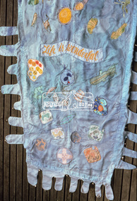
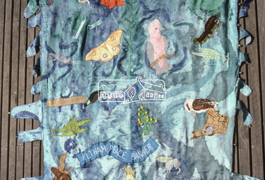 Eltham District Historical Society Inc
Photograph, "As we are" Community Banner Project, c.Oct. 1986
... water lost in the river of life - yet rivers were made of countless droplets which, when joined together, became the powerful force of the river. This group quickly established a commitment, not only to peace, but to the group itself, and this has continued beyond the project. The women, as is the case with many of the groups in the Banner Project, were really surprised at their increasing textile skills and self-confidence. But they were more concerned with their commitment to peace. Each is continuing to find ways...water lost in the river of life - yet rivers were made of countless droplets which, when joined together, became the powerful force of the river. This group quickly established a commitment, not only to peace, but to the group itself, and this has continued beyond the project. The women, as is the case with many of the groups in the Banner Project, were really surprised at their increasing textile skills and self-confidence. But they were more concerned with their commitment to peace. Each is continuing to find ways ...River of Life and Hiroshima Day Banners The River of Life and Hiroshima Day banners were specific peace projects initiated by the CAO and taken up by Eltham Living & Learning Centre and funded by the Victorian Peace Secretariat for IYP. The project was transferred from the Centre to Tracey as part of her artist in the community portfolio. Tracey, as CAO, employed Jacky Talbot, who was not familiar with Eltham but was an experienced community arts worker personally interested in textiles and peace. The project was publicised and a peace banner group formed. Only two of the women knew each other. They had come together from a need to do something for peace, rather than to learn about textiles. Jacky Talbot shared Elizabeth Savage's approach to the banner. She was not 'a peace-expert' and did not want to be seen as such by the group. Like Elizabeth Savage she wanted to encourage an expression of peace as it was perceived by the group. Jacky showed slides of peace images and peace banners. Textile workshops were interspersed with discussions about peace, one of which was led by a local People for Nuclear Disarmament member. The idea for the banner occurred during one of these discussions. One of the women began to talk about feeling like a drop of water lost in the river of life - yet rivers were made of countless droplets which, when joined together, became the powerful force of the river. This group quickly established a commitment, not only to peace, but to the group itself, and this has continued beyond the project. The women, as is the case with many of the groups in the Banner Project, were really surprised at their increasing textile skills and self-confidence. But they were more concerned with their commitment to peace. Each is continuing to find ways in which she can continue to work for peace, and activities are undertaken on a group basis as well. The decision to participate in the group based activities is up to each woman as the time arises. The banner and some members of the group have now participated in the Peace Boogie at the World Trade Centre, the Peace Arts Conference organised by Art Action for Peace, Melbourne City Council's Peace Vigil weekend, Women's Precious Things for Peace Day exhibition and the banner was ' hung at the Footscray Community Arts Centre when the other textile peace mural Jacky co-ordinated was opened. One woman wrote a poem about the project and peace; others have sent telegrams and letters to politicians about peace. A great deal of information about peace and other activities, articles, books, media programs were circulated amongst the group. The Hiroshima Day Banner was made by Jacky Talbot as part of the project. The women wanted to do something for Hiroshima Day and suggested that a workshop be set aside to make a banner. The artist was concerned about the remaining time scheduled for the project and spent several days "whipping" up the banner herself. For the artist this banner was to prove quite significant. The women hung it at the Community Notice Board on Hiroshima Day and were photographed by the local newspaper publicising the group and drawing wider community attention to the remembrance of the day. Although no new members joined the group from this activity, the artist felt that she was more fully accepted by the group afterwards. This banner has initiated a small group of women committed to peace. The artist has also continued to liaise and meet with the women as time permits. Future group plans include: making kimonos to wear when carrying the banner, participating in the Palm Sunday March, an observance of Hiroshima Day activity, which is yet to be decided, establishing contact with a sister-town in USA and USSR and supporting Eltham Council's stance as a Nuclear Free Zone. (Source: The banner habits of the Eltham tribes : Eltham Shire "as we are" Community Banner Project report / by Jacky Talbot, Shire of Eltham, Feb. 1987, pp43-46)35mm colour positive transparency (1 of 2) Mount - Kodak KodachromeProcess Date OCT 86Mbanner project, community banner project, tracey naughton, eltham living and learning centre, eltham peace banner, jacky talbot, river of life banner -
 Eltham District Historical Society Inc
Photograph, "As we are" Community Banner Project, c.Oct. 1986
... water lost in the river of life - yet rivers were made of countless droplets which, when joined together, became the powerful force of the river. This group quickly established a commitment, not only to peace, but to the group itself, and this has continued beyond the project. The women, as is the case with many of the groups in the Banner Project, were really surprised at their increasing textile skills and self-confidence. But they were more concerned with their commitment to peace. Each is continuing to find ways...water lost in the river of life - yet rivers were made of countless droplets which, when joined together, became the powerful force of the river. This group quickly established a commitment, not only to peace, but to the group itself, and this has continued beyond the project. The women, as is the case with many of the groups in the Banner Project, were really surprised at their increasing textile skills and self-confidence. But they were more concerned with their commitment to peace. Each is continuing to find ways ...River of Life and Hiroshima Day Banners The River of Life and Hiroshima Day banners were specific peace projects initiated by the CAO and taken up by Eltham Living & Learning Centre and funded by the Victorian Peace Secretariat for IYP. The project was transferred from the Centre to Tracey as part of her artist in the community portfolio. Tracey, as CAO, employed Jacky Talbot, who was not familiar with Eltham but was an experienced community arts worker personally interested in textiles and peace. The project was publicised and a peace banner group formed. Only two of the women knew each other. They had come together from a need to do something for peace, rather than to learn about textiles. Jacky Talbot shared Elizabeth Savage's approach to the banner. She was not 'a peace-expert' and did not want to be seen as such by the group. Like Elizabeth Savage she wanted to encourage an expression of peace as it was perceived by the group. Jacky showed slides of peace images and peace banners. Textile workshops were interspersed with discussions about peace, one of which was led by a local People for Nuclear Disarmament member. The idea for the banner occurred during one of these discussions. One of the women began to talk about feeling like a drop of water lost in the river of life - yet rivers were made of countless droplets which, when joined together, became the powerful force of the river. This group quickly established a commitment, not only to peace, but to the group itself, and this has continued beyond the project. The women, as is the case with many of the groups in the Banner Project, were really surprised at their increasing textile skills and self-confidence. But they were more concerned with their commitment to peace. Each is continuing to find ways in which she can continue to work for peace, and activities are undertaken on a group basis as well. The decision to participate in the group based activities is up to each woman as the time arises. The banner and some members of the group have now participated in the Peace Boogie at the World Trade Centre, the Peace Arts Conference organised by Art Action for Peace, Melbourne City Council's Peace Vigil weekend, Women's Precious Things for Peace Day exhibition and the banner was ' hung at the Footscray Community Arts Centre when the other textile peace mural Jacky co-ordinated was opened. One woman wrote a poem about the project and peace; others have sent telegrams and letters to politicians about peace. A great deal of information about peace and other activities, articles, books, media programs were circulated amongst the group. The Hiroshima Day Banner was made by Jacky Talbot as part of the project. The women wanted to do something for Hiroshima Day and suggested that a workshop be set aside to make a banner. The artist was concerned about the remaining time scheduled for the project and spent several days "whipping" up the banner herself. For the artist this banner was to prove quite significant. The women hung it at the Community Notice Board on Hiroshima Day and were photographed by the local newspaper publicising the group and drawing wider community attention to the remembrance of the day. Although no new members joined the group from this activity, the artist felt that she was more fully accepted by the group afterwards. This banner has initiated a small group of women committed to peace. The artist has also continued to liaise and meet with the women as time permits. Future group plans include: making kimonos to wear when carrying the banner, participating in the Palm Sunday March, an observance of Hiroshima Day activity, which is yet to be decided, establishing contact with a sister-town in USA and USSR and supporting Eltham Council's stance as a Nuclear Free Zone. (Source: The banner habits of the Eltham tribes : Eltham Shire "as we are" Community Banner Project report / by Jacky Talbot, Shire of Eltham, Feb. 1987, pp43-46)35mm colour positive transparency Mount - Black and Whitebanner project, community banner project, tracey naughton, eltham living and learning centre, eltham peace banner, jacky talbot, river of life banner -
 Eltham District Historical Society Inc
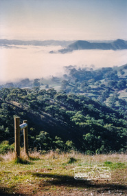
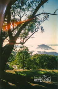
Photograph, Murchison Gap, Autumn Excursion, Hume and Hovell's 1824 expedition, 26 May 1996, 26/05/1996
... Our next river crossing was at Werribee, "in a vast treeless plain", then we drove on by-ways no coach had previously travelled, to find "an immense sheet of water" salty Corio Bay, off-course to the west. ...Our next river crossing was at Werribee, "in a vast treeless plain", then we drove on by-ways no coach had previously travelled, to find "an immense sheet of water" salty Corio Bay, off-course to the west. ...[article by Bettina Woodburn in EDHS Newsletter No. 109, July 1996:] ON THE TRAIL OF HUME AND HOVELL - REPORT ON THE AUTUMN EXCURSION - On a green and fresh morning (Sunday 26th May 1996) the Cobb and Co coach (driven by the most obliging Peter Tampion) set off in a north easterly direction from Eltham to connect with Hume and Hovell's route on their 1824 explorations of central Victoria. The Society would follow a series of monuments erected for the 1924 centenary of the expedition from King Parrot Creek (Tuesday 7th December 1824), through Strath Creek, over Sunday Creek (Sunday 12th December 1824) at Broadford, Tullamarine, St Albans, Deer Park, through Werribee, skirting east of the You Yangs to Lara and Avalon Beach. Because their distance-measuring wheel had broken and a one degree mistake was made in calculations, the two leaders of the original group of six convict-companions arrived at Corio Bay, instead of the expected Western Port, discovered earlier by Flinders. From below Mt. Disappointment (Hume and Hovell's difficulties in "scrambling over brush and rock", "leeches in forest, as well as no water", "cutting grass 4-5 ft. high", dreadful scrub", "devil flies") we took an easier route, saw the Strath Creek memorial in ground fog and a wonderful "field of dreams", the Hume-Hovell privately owned cricket ground with its white picket boundary fence. Now, after a steep climb, in sunshine under gums we stretched and viewed magnificent rolling hills and fog-filled valleys - not "smoke from Aborigines' bush fires". After morning tea at Broadford we followed the Sunday Creek valley beside the Hume Freeway, passed the Wallan Wallan Rest Area (more appropriately Hume and Hovell Rest Area) to tum right at Beveridge. In Gellibrand Hill Park, near the headwaters of the Moonee Ponds Creek, we experienced the landscape the first European settlers saw - huge river red gums and rolling pastures. The gardens and sheltered courtyard of the 1840s, timber, brought from .....[?] prefabricated Woodlands Homestead, provided a pleasant lunch stop. We enjoyed a private tour, panoramic views over Melbourne and surroundings and the excitement of arriving and departing aircraft. Our next river crossing was at Werribee, "in a vast treeless plain", then we drove on by-ways no coach had previously travelled, to find "an immense sheet of water" salty Corio Bay, off-course to the west. In late afternoon of a super, calm, late autumn day we headed homewards. Back at Eltham we were rather surprised to find that we had travelled a total of 347 km. Thanks again to Russell Yeoman for his research and organization. What a wonderful day! Three colour photographsactivities, murchison gap, murchison valley -
 Eltham District Historical Society Inc
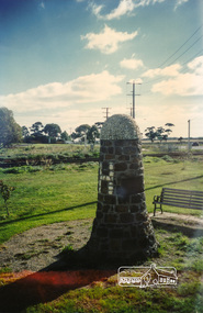
Photograph, Hume and Hovell Monument, Broadford, Autumn Excursion, Hume and Hovell's 1824 expedition, 26 May 1996, 26/05/1996
... Our next river crossing was at Werribee, "in a vast treeless plain", then we drove on by-ways no coach had previously travelled, to find "an immense sheet of water" salty Corio Bay, off-course to the west. ...Our next river crossing was at Werribee, "in a vast treeless plain", then we drove on by-ways no coach had previously travelled, to find "an immense sheet of water" salty Corio Bay, off-course to the west. ...[article by Bettina Woodburn in EDHS Newsletter No. 109, July 1996:] ON THE TRAIL OF HUME AND HOVELL - REPORT ON THE AUTUMN EXCURSION - On a green and fresh morning (Sunday 26th May 1996) the Cobb and Co coach (driven by the most obliging Peter Tampion) set off in a north easterly direction from Eltham to connect with Hume and Hovell's route on their 1824 explorations of central Victoria. The Society would follow a series of monuments erected for the 1924 centenary of the expedition from King Parrot Creek (Tuesday 7th December 1824), through Strath Creek, over Sunday Creek (Sunday 12th December 1824) at Broadford, Tullamarine, St Albans, Deer Park, through Werribee, skirting east of the You Yangs to Lara and Avalon Beach. Because their distance-measuring wheel had broken and a one degree mistake was made in calculations, the two leaders of the original group of six convict-companions arrived at Corio Bay, instead of the expected Western Port, discovered earlier by Flinders. From below Mt. Disappointment (Hume and Hovell's difficulties in "scrambling over brush and rock", "leeches in forest, as well as no water", "cutting grass 4-5 ft. high", dreadful scrub", "devil flies") we took an easier route, saw the Strath Creek memorial in ground fog and a wonderful "field of dreams", the Hume-Hovell privately owned cricket ground with its white picket boundary fence. Now, after a steep climb, in sunshine under gums we stretched and viewed magnificent rolling hills and fog-filled valleys - not "smoke from Aborigines' bush fires". After morning tea at Broadford we followed the Sunday Creek valley beside the Hume Freeway, passed the Wallan Wallan Rest Area (more appropriately Hume and Hovell Rest Area) to tum right at Beveridge. In Gellibrand Hill Park, near the headwaters of the Moonee Ponds Creek, we experienced the landscape the first European settlers saw - huge river red gums and rolling pastures. The gardens and sheltered courtyard of the 1840s, timber, brought from .....[?] prefabricated Woodlands Homestead, provided a pleasant lunch stop. We enjoyed a private tour, panoramic views over Melbourne and surroundings and the excitement of arriving and departing aircraft. Our next river crossing was at Werribee, "in a vast treeless plain", then we drove on by-ways no coach had previously travelled, to find "an immense sheet of water" salty Corio Bay, off-course to the west. In late afternoon of a super, calm, late autumn day we headed homewards. Back at Eltham we were rather surprised to find that we had travelled a total of 347 km. Thanks again to Russell Yeoman for his research and organization. What a wonderful day! Colour photographactivities, broadford, hume and hovell, monument -
 Eltham District Historical Society Inc
Photograph, Hume and Hovell Monument, Autumn Excursion, Hume and Hovell's 1824 expedition, 26 May 1996, 26/05/1996
... Our next river crossing was at Werribee, "in a vast treeless plain", then we drove on by-ways no coach had previously travelled, to find "an immense sheet of water" salty Corio Bay, off-course to the west. ...Our next river crossing was at Werribee, "in a vast treeless plain", then we drove on by-ways no coach had previously travelled, to find "an immense sheet of water" salty Corio Bay, off-course to the west. ...[article by Bettina Woodburn in EDHS Newsletter No. 109, July 1996:] ON THE TRAIL OF HUME AND HOVELL - REPORT ON THE AUTUMN EXCURSION - On a green and fresh morning (Sunday 26th May 1996) the Cobb and Co coach (driven by the most obliging Peter Tampion) set off in a north easterly direction from Eltham to connect with Hume and Hovell's route on their 1824 explorations of central Victoria. The Society would follow a series of monuments erected for the 1924 centenary of the expedition from King Parrot Creek (Tuesday 7th December 1824), through Strath Creek, over Sunday Creek (Sunday 12th December 1824) at Broadford, Tullamarine, St Albans, Deer Park, through Werribee, skirting east of the You Yangs to Lara and Avalon Beach. Because their distance-measuring wheel had broken and a one degree mistake was made in calculations, the two leaders of the original group of six convict-companions arrived at Corio Bay, instead of the expected Western Port, discovered earlier by Flinders. From below Mt. Disappointment (Hume and Hovell's difficulties in "scrambling over brush and rock", "leeches in forest, as well as no water", "cutting grass 4-5 ft. high", dreadful scrub", "devil flies") we took an easier route, saw the Strath Creek memorial in ground fog and a wonderful "field of dreams", the Hume-Hovell privately owned cricket ground with its white picket boundary fence. Now, after a steep climb, in sunshine under gums we stretched and viewed magnificent rolling hills and fog-filled valleys - not "smoke from Aborigines' bush fires". After morning tea at Broadford we followed the Sunday Creek valley beside the Hume Freeway, passed the Wallan Wallan Rest Area (more appropriately Hume and Hovell Rest Area) to tum right at Beveridge. In Gellibrand Hill Park, near the headwaters of the Moonee Ponds Creek, we experienced the landscape the first European settlers saw - huge river red gums and rolling pastures. The gardens and sheltered courtyard of the 1840s, timber, brought from .....[?] prefabricated Woodlands Homestead, provided a pleasant lunch stop. We enjoyed a private tour, panoramic views over Melbourne and surroundings and the excitement of arriving and departing aircraft. Our next river crossing was at Werribee, "in a vast treeless plain", then we drove on by-ways no coach had previously travelled, to find "an immense sheet of water" salty Corio Bay, off-course to the west. In late afternoon of a super, calm, late autumn day we headed homewards. Back at Eltham we were rather surprised to find that we had travelled a total of 347 km. Thanks again to Russell Yeoman for his research and organization. What a wonderful day! Two colour photographsactivities, hume and hovell, monument -
 Yarra City Council
Artwork, other - Installation/Sculpture, Troy Innocent, Joel Collins, Indae Hwang, Yun Tae Nam, Drop Zone, 2011
... The aims of this project included activating public spaces in new and creative ways through the creation of artworks which act as catalysts for further engagement and discussion around environmental themes and issues. Many environmental reports discuss the increasing scarcity of fresh water around the world. ...'Drop Zone', is set in an imagined future where decreasing water availability has affected us more dramatically than anyone predicted. The water shortage has become so severe that we have to access water on a first-come first-serve basis, from military-like water ‘drop zones’, like this one, made from modified rain water tanks. These tanks function on three levels: Collected rain water causes the totem sculptures to rise and bloom; evaporation causes the totem sculptures to fall; and an anemometer (device that measures wind speed) drives a process that plays the tank like a giant drum, tuned by the amount of water contained within. This artwork envisions a future for Australia where the impact of decreasing water availability has had a more dramatic effect than any of the predictions. The shortage is so severe that military-like water ‘drop zones’, constructed of modified rainfall storage tanks have been established across the public parks of the City of Yarra for access on a first come, first serve basis. However, as the water is only replenished through rain catchment the tanks may only offer infrequent relief for the City of Yarra residents, standing as hollow reminders of the effects of inaction on the shaping of sustainable national water use.'Drop Zone' was one of three public art works installed in Yarra, in 2011, under the banner of The Environmental Public Arts Project which responded to key features of Council's Environment Strategy: 'Towards Local Sustainability 2008-2020.' The aims of this project included activating public spaces in new and creative ways through the creation of artworks which act as catalysts for further engagement and discussion around environmental themes and issues.Copyright the Artists. Ready-made corrugated water tanks arranged on a site. Situated within the tanks are small totemic sculptures that float on top of the water within the tank.Accompanying plaquesustainability, water, environment, climate change -
 Flagstaff Hill Maritime Museum and Village
Functional object - Hinge, 1800s to early 1900s
... water for over 100 years, as the more widely known shipwrecks along Victoria’s Shipwreck Coast date from 1837 to 1940. Before the Middle Ages metal was expensive and took a lot of effort to work with As time went on, methods were discovered for working more easily with metals, and ways were found for combining different metals to make alloys that made the metals stronger and more durable. ...water for over 100 years, as the more widely known shipwrecks along Victoria’s Shipwreck Coast date from 1837 to 1940. Before the Middle Ages metal was expensive and took a lot of effort to work with As time went on, methods were discovered for working more easily with metals, and ways were found for combining different metals to make alloys that made the metals stronger and more durable. ...This flat hinge was recovered from an unknown shipwreck in the coastal waters of Victoria in the late 1960s to early 1970s. It is part of the John Chance Collection. The size of the hinge indicates that it was used for a large item such as an entry door, gate or perhaps a ship fitting. The blue-green patina on the metal is caused by a reaction from its exposure to external elements such as the sea water. The hinge is likely to have been in the water for over 100 years, as the more widely known shipwrecks along Victoria’s Shipwreck Coast date from 1837 to 1940. Before the Middle Ages metal was expensive and took a lot of effort to work with As time went on, methods were discovered for working more easily with metals, and ways were found for combining different metals to make alloys that made the metals stronger and more durable. Hinges forged by blacksmiths began to be common in homes. In the Victorian Era steam power was introduced and manufacturing boomed. Hinges could be made by machines quickly and in great number. All sorts of applications were found to take advantage of the features of hinges. They continue to be developed and used in a huge variety of ways. Although the hinge is not linked to a particular shipwreck, it is recognised as being historically significant as an example of hardware either as part of the ship’s fittings or imported for use in Colonial Victoria in the 19th to early 20th century. The hinge is also significant as it was recovered by John Chance, a diver in Victoria’s coastal waters in the late 1960s to early 1970s. Items that come from several wrecks have since been donated to the Flagstaff Hill Maritime Village’s museum collection by his family, illustrating this item’s level of historical value. Hinge; heavy bronze flat hinge, hand forged. Flat with narrow, arrow shaped end that lares outward to wider straight end. Attached to the wide end is a rectangular, upward curved knuckle. There are five formed holes along the hinge, two are oval shaped and three are round. The hinge has a blue-green patina.flagstaff hill, warrnambool, flagstaff hill maritime museum, maritime museum, shipwreck coast, flagstaff hill maritime village, great ocean road, john chance, hinge, hardware, flat hinge, door fitting, ship’s fitting, 19th century metalwork, forged hinge -
 Ballarat Tramway Museum
Film - Movie Film & Box, 1970s
... Time Sequence Description 0:00 Starts with a training running past, view of wooden carriages, C van and then interior shots of train, toilets, washbasin, electrical equipment, water dispenser, signs, seats, walk ways between carriages and light fittings. 1:20 End Placed in a blue cardboard box specially made for the item 30/08/2010. ...Time Sequence Description 0:00 Starts with a training running past, view of wooden carriages, C van and then interior shots of train, toilets, washbasin, electrical equipment, water dispenser, signs, seats, walk ways between carriages and light fittings. 1:20 End Placed in a blue cardboard box specially made for the item 30/08/2010. ...Movie Film - 16mm on a black metal reel, 91mm dia. Title: Train Carriages Interior Shots – Length 1:20 mins, colour, 16mm Colour with sound. (Reg Item 4110 - source not known at this time.) Time Sequence Description 0:00 Starts with a training running past, view of wooden carriages, C van and then interior shots of train, toilets, washbasin, electrical equipment, water dispenser, signs, seats, walk ways between carriages and light fittings. 1:20 End Placed in a blue cardboard box specially made for the item 30/08/2010. trams, tramways, victorian railways -
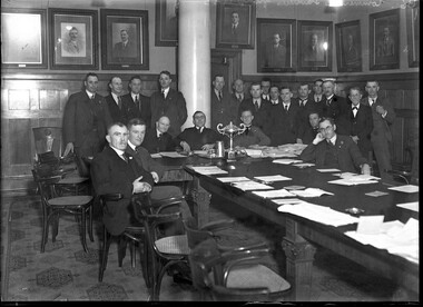 City of Melbourne Libraries
Photograph, Bull, Hugh Jones, 1897-1993, Commercial Travellers' Association, Victoria, Board Room
... water scheme and maintaining the White Australia Policy. They were very active in fund raising for the war efforts. The CTA offered its members support in other ways with benevolent funds for widows and orphans, mortuary, accident, sickness and an annuities fund for members over 65 years. ...water scheme and maintaining the White Australia Policy. They were very active in fund raising for the war efforts. The CTA offered its members support in other ways with benevolent funds for widows and orphans, mortuary, accident, sickness and an annuities fund for members over 65 years. ...Seven seated and fifteen standing men dressed in suits around a long table in a panelled room hung with formal portraits of men. A trophy sits on the long table amongst loose paper sheets. Research by project volunteer, Fiona Collyer: The Commercial Travellers’ Association of Victoria (CTA) was formed at a meeting of 40 commercial travellers held at the Duke of Rothesay Hotel, 24 Elizabeth Street on 1 December 1880. Their charter was to advocate for better working conditions for commercial travelling salesmen, including improved accommodation at discounted rates and travel concession fares. At first by locomotive, horse and buggy, steamers and horseback, later also by motor car and motorcycle, “The Man on the Road” went into the back-blocks of the country to extend the interests of commerce to the stores and households of Australian regional towns and isolated settlements. Affiliated organisations existed in all states and New Zealand and in 1895 they integrated to form the United Commercial Travellers’ Association of Australasia (UCTAA). By the turn of the 20th century, the Victorian branch of the CTA had 421 Association Members and 520 Club members. The CTA continued to hold meetings in leased rooms in hotels and offices until 1898 when they commissioned purpose-built premises at 190-192 Flinders Street (extant, now the Macstore, next to former Metropolitan Gas Company Buildings). Designed by leading architectural firm of brothers H.W. & F.B.Tompkins (Dimmey’s Model Store, Swan Street, London Stores, Herald and Weekly Times, Myer building, Diamond House, Centreway Arcade, Manton’s Store) in the Queen Anne Revival style at the cost of £20,000, the four storey building had a facade of red Northcote bricks and an entrance of Pyrmont stone. It was very modern for the time, featuring elevators, offices, bars, kitchen, dining, card and billiard rooms and 31 bedrooms with shared bathrooms for the footsore travellers. However, despite adding two storeys in 1901, and another storey and a basement in 1905, they soon outgrew their premises, and in 1912 the CTA commissioned a new building at 328 Flinders Street. At this time, buildings in Melbourne were constrained by the city height limit of 132 feet (40 metres)- the maximum height of firefighting ladders. The new CTA building was the tallest building in Melbourne until 1932 when regulations changed allowing the Manchester Unity Building to be built. The new CTA headquarters was the epitome of comfort and luxury with cutting edge facilities to ease the fatigued salesman and prepare him for another stint on the road. General Secretary, James Davies travelled to Britain and America to acquire the very best and latest innovations. After visiting the new premises, Punch magazine 11 June 1914 reported “furnishings, appliances, and labour-saving conveniences which were more than up to date- they were up to-morrow.” The Edwardian Baroque style building was again designed by architects H.W. & F.B. Tompkins at the cost of £100,000 and built by contractors F.E. Shillabeer and Sons (Nicholas Building, Kellow-Falkiner Pty Ltd car showroom). The nine storey plus basement building is of steel frame construction with concrete floors. The ground floor facade is of grey granite and above that it is faced with cream glazed bricks chosen to combat discolouration from the pollution emitted by Flinders Street Station trains across the road. The facade is decorated with mascarons, gum leaf trim and balconies with classical style balustrade. The club was entered through revolving doors into a two storey high, circular, domed lobby with white columns, American oak panelled walls and intricate mosaic flooring. The ceiling is festooned with plaster gum leaf and gum nut detail, a theme that is repeated throughout the building. The basement kitchen had modern, labour saving appliances that would be the envy of any Edwardian housewife, including an electric toaster, a potato peeling machine, heated dumb waiter, dishwashing machine and electric refrigeration and cooking. It serviced the commodious second floor dining room which seated 200 people and the cafe/breakfast room, 80 people. Members were permitted to entertain their lady friends there for afternoon tea between the hours of 3 and 5 pm every day, except Sunday. The members’ facilities included a barbershop, clothes pressing machine, boot cleaning chair, pipe and cigar stall with electric humidor, public telephones, lockers and safe deposit. The building was serviced with five elevators, a built in vacuum cleaning plant, hot water radiators and linen and postal chutes. The first floor was devoted to business and relaxing, containing the Board, Writing, Reading and four Business Rooms. The board room had Queensland maple panelling with huge blackwood tables topped with blue morocco and golden tortoise-shell trim and cane bottomed chairs. Large framed photographs of past presidents since 1884 lined the walls. The Reading Room ran the whole width of the building. Arthur Streeton’s painting “Between the Lights, Princes Bridge 1888” and Frederick McCubbin’s “Looking North from Mount Macedon” were hung there, as well as paintings by renowned Australian artists Hans Heysen, Walter Withers, John Mather, Jan Hendrik Scheltema. The Argus 30 May 1914 quipped “Around the walls hang evidences that the commercial traveller's soul has not been killed in his pursuit of commerce”. The blackwood panelled room was furnished with Queen Anne style tables and chairs and green leather armchairs with inviting rocker foot rests allowing weary travellers to relax after traversing the railways and dusty roads of Victoria while planning their next sales trip. “The Australasia Traveller” Volume 10, Number 2, April 1914 page 35 noted “An attendant will be constantly employed on this floor to take care of the stationary supply, to tidy up newspapers, and generally study the convenience of members.” The third floor was for amusements with billiards, a bar and four rooms for playing cards, dominoes and chess. The huge billiard room had seven Alcock billiard tables including a table in a partitioned match-room for tournaments, exhibitions and matches. The walls were lined with members’ cues and for spectators, comfortable lounges with marble topped tables and electric bell pushes for drinks service. There were 150 bedrooms over five floors, each with their own telephone and wash basin and five suites with a private sitting room attached. There were four bathrooms per bedroom floor and capacious, well-lighted shaving rooms. Top rate club tariff for bed and breakfast - 6 shillings, if called for a country train leaving Melbourne before 8am - 4 shillings, suite and breakfast- 9 shillings, sixpence. “The Australasia Traveller” Volume 10, Number 2, April 1914 page 35 reported “All “early calls” will be made from the Club Office to Bedrooms by means of the Telephone, so that instead of waking everybody else up on the corridor, only the member concerned will know that it is his unpleasant duty to get up.” The new CTA premises was widely regarded as the finest club in the Southern Hemisphere. The CTA also built the adjacent six storey Commerce House with 52 sample rooms for travellers to display their wares with the remainder rented to retail businesses and a post and telegraph office. After the CTA moved into their new, larger premises in 1914, neighbouring department store Ball & Welch expanded into the former CTA. The CTA saw themselves in a nation building role and were an influential lobby group to the Government. They advocated for inter city trunk telephone lines, standard gauge railway lines between NSW and Victoria, improved roads and highways, the Murray River water scheme and maintaining the White Australia Policy. They were very active in fund raising for the war efforts. The CTA offered its members support in other ways with benevolent funds for widows and orphans, mortuary, accident, sickness and an annuities fund for members over 65 years. There were scholarships for members’ children and home purchase scheme to assist with home ownership. A secondary membership scheme provided access to non commercial travellers (men only) to its exclusive club premises. They also organised social events and activities such as billiard tourneys, golf tournaments, dances and an annual “Smoke Social” which was a social event where men gathered for a formal dinner, community singing, lectures, speeches and of course, to smoke! Daylesford born James Davies OBE, (1865-1931) worked at the CTA for 50 years, starting as an office boy and working his way up to General Secretary and editor of the monthly trade journal for UCTAA members, “The Traveller” (1890-1905, later “The Australasian Traveller” 1905-1924 and then “The Australian Traveller” 1925-1976) and the annual colour supplement magazine “Australia To-Day” (1904-1973). “The Australasia Traveller” featured commentary on the issues of the day like wars, tariffs and trade, articles on new products and hotel recommendations and their rates and lots of advertising, especially alcohol, tobacco and accommodation in regional hotels. There were regular columns, each illustrated with a line drawing and these included “Our Immigration Record” a state by state summary of arrivals of “desirable immigrants” to Australia, while bemoaning the declining (white) birth rate. The column followed the arrival of British boys sent to Australia as agricultural apprentices to work on rural properties which were short of labour. Between 1913-1928, 1750 “Barwell Boys”, some as young as 14 years of age arrived in South Australia to work. NSW had a similar program known as the Dreadnaught Boys Scheme where 5595 boys immigrated between 1911-1939. The boys were considered of “good British stock”. There was a “Home Page For The Ladies” showcasing the latest fashions in women’s clothing, millinery and hairstyles and tips and trends in home furnishings.“Children’s Corner for Dear Little Folks” which featured puzzles, jokes and stories and members could send in photographs of their children. “Road Echoes” devoted to “The Man On The Road” and his doings. “Face Massage, Smiling is the Best Face Massage”, the humour page full of jokes and funny stories. “Railway Rumbles” news of innovations, timetables, tickets and grumbles about lavatories, food and drinking water on trains and at railway stations. And in case we forget that members had a home away from their CTA home, gardening tips with “The C.T. as Gardener”column. The annual magazine “Australia To-Day” was a vehicle to promote Australia here and overseas as a modern, prosperous country with abundant opportunities and pleasant climate. It sought to showcase its manufacturing, agriculture and tourism and encourage British immigration to Australia. The magazine featured articles about recently arrived migrants at work, quirky native flora and fauna, beach culture, recreation and the Australian way of life in the settler nation. Many of the articles were written by politicians of the day, including Robert Menzies. The UCTAA commissioned original artwork for the front covers and feature articles of “Australia To-day” from leading Australian artists. These included Norman Lindsay, Frederick McCubbin, Napier Waller, Lionel Lindsay, Hans Heysen, C Dudley Wood, Louis McCubbin, Penleigh Boyd, Louis Buvelot, Christian Waller and Ellis Rowan and her Australian wildflowers. Some of the photographs in “Australia To-Day” were provided by state and federal government departments as well as manufacturers, newspapers and mining companies. Amongst of the credited photographers was Helmut Newton who later earned world acclaim as a fashion photographer and architectural and industrial photographer Wolfgang Sievers (unfortunately their photographs remain in copyright and aren’t available online). Also featured was Richard C. Strangman, a professional photographer from Canberra, William Howieson of Melbourne, who has 22 photographs in the collection of NGV, Tasmanian wilderness photographer Frederick Smithies, Athol Shmith, portrait photographer and educator from Melbourne, Gordon de Lisle, a Melbourne commercial, industrial, aerial and society portrait photographer. (One of Gordon’s assignments was as the stills photographer for the 1959 movie “On The Beach” filmed in Melbourne). Photographs taken by acclaimed Antarctic and official war photographer Captain Frank Hurley OBE for Adelaide’s Centenary were also featured. The Australian Government was keenly aware of the influence and quality of the UCTAA publications. On 1 June 1914 The Age reported that to advertise Australia in Great Britain and elsewhere, the Department of External Affairs purchased 6500 copies of “Australia To-Day” magazine for £515 to distribute free to “places where they are most likely to come under the notice of a desirable class of immigrants.” In 1950, the office of Prime Minister Robert Menzies ordered 2550 copies of that year’s issue of “Australia To-Day” for the Department of Commerce and Information to distribute. The CTA donated their archives to University of Melbourne Archives which includes original artworks and photos used in “Australia To-Day” (Melbourne University has digitised 1114 photos) and sundry items including trophies, ashtrays, commemorative souvenirs, menus, a rare “Safechek” sovereign changer, a bust of James Davies and even a CTA embossed wash bowl and chamber pot. After the death of General Secretary James Davies in 1931, the CTA held the annual “James Davies Memorial Cup” golf tournament at various Melbourne golf courses, the winner receiving a splendid silver cup. “Table Talk” magazine photographs from 29 June 1933 depict the travellers beautifully (and I would say correctly) attired in tweedy plus fours, Fair Isle knitwear, flat caps and of course fringed brogues. I have been unable to ascertain whether the trophy in our photo is for golf or another CTA social activity. The CTA Victoria membership peaked in 1951 with 4,672 Aassociation members and 3,693 Club members. In 1959, Hollywood came to Melbourne when film stars Gregory Peck, Ava Gardner, Anthony Perkins and Fred Astaire descended to film ‘On the Beach,’ directed by Stanley Kramer. The film is based on the bestselling Neville Shute novel about the aftermath of World War Three, a nuclear war that has obliterated most of the Northern Hemisphere. Radioactive dust is heading toward Australia and everyone is preparing for death. Scenes with Anthony Perkins were filmed in the CTA billiards room as the exclusive Pastoral Club. Anthony Perkins’ character, Lieutenant Commander Peter Holmes of RAN tells Gregory Peck’s character, Commander Dwight Lionel, that The Pastoral Club is…”A mahogany and polished brass sort of place-some people claim it was the stuffiest club in the Commonwealth” before assuring him that despite shortages, the club is likely to have some Scotch left. In a scene at the Pastoral Club two, old (probably red faced) codgers discuss the challenge of drinking all of the 400 bottles of Gould Campbell vintage port in the club wine cellar before they succumb to radiation sickness in five months time. The NGV has 12 photographs in their collection of wardrobe stills of Ava Gardner modelling costumes designed by the Fontana Sisters of Rome for “On The Beach”, taken by Italian photographer G.B.Poletto. During the filming, Gregory Peck and his family stayed at “Kurneh” 206 Domain Road, South Yarra, the former home of three times Grand Slam winner Norman Brookes. Through the decades, Australian society was changing and in order to stay relevant, the CTA had to change too. In 1971, two women were elected for club membership, although they were only granted limited access to the club’s facilities and in 1972, women were invited for the first time to participate in the previously men only annual “Smoke Social”. In 1975, dwindling membership forced the closure of The Commercial Travellers’ Association building and in 1977, the building was sold, with the CTA ceasing to operate in 2014. It was the end of the road for the “Knights of the Road”. In 1992, the CTA building at 328 Flinders Street was placed on the Victorian Heritage Register in recognition of its architectural and cultural significance. The building has been meticulously restored with many of the original fittings, decorative plasterwork, mosaic flooring, stained glass windows, columns, chandeliers and the panelling made from Australian timbers retained. After renovations the building became first the Euro Asia Hotel, then the Duxton Hotel and in 2005 The Rendezvous Hotel, Melbourne. In tribute to the history of the building and the film “On The Beach”, the Rendezvous Hotel has the Ms Ava Bar, Perkins room, Mr Tompkins restaurant, Commerce Room and the Davies Room. References: COMMERCIAL TRAVELLERS' ASSOCIATION OF VICTORIA. (1899, May 27). The Australasian (Melbourne, Vic. : 1864 - 1946), p. 25. Retrieved February 21, 2025, from http://nla.gov.au/nla.news-article138615498 COMMERCIAL TRAVELLERS. (1914, May 30). The Argus (Melbourne, Vic. : 1848 - 1957), p. 8. Retrieved February 13, 2025, from http://nla.gov.au/nla.news-article7272511 NEWS OF THE DAY. (1914, June 1). The Age (Melbourne, Vic. : 1854 - 1954), p. 8. Retrieved February 19, 2025, from http://nla.gov.au/nla.news-article189414314 COMMERCIAL TRAVELLERS' "AT HOME." (1914, June 11). Punch (Melbourne, Vic. : 1900 - 1918; 1925), p. 32. Retrieved March 19, 2025, from http://nla.gov.au/nla.news-article129699692 https://archives.library.unimelb.edu.au/nodes/view/69669 https://vhd.heritagecouncil.vic.gov.au/places/757 http://www.pikitiapress.com/blog/2015/1/26/australia-today Commercial Travellers at Yarra Yarra (1933, June 29). Table Talk (Melbourne, Vic. : 1885 - 1939), p. 6. Retrieved February 28, 2025, from http://nla.gov.au/nla.news-article149547845 https://archives.library.unimelb.edu.au/nodes/view/537460 https://viewer.slv.vic.gov.au/?entity=IE7420895&file=FL19171568&mode=browse https://www.history.sa.gov.au/wp-content/uploads/2021/03/Barwell_Boys_Catalogue-compressed-compressed-compressed.pdf Australia Today," 1927 (1926, December 11). Weekly Times (Melbourne, Vic. : 1869 - 1954), p. 15. Retrieved March 17, 2025, from http://nla.gov.au/nla.news-article223844810 https://blogs.unimelb.edu.au/librarycollections/2020/12/19/an-inhabited-space-helmut-newtons-lovers/ https://www.ngv.vic.gov.au/explore/collection/artist/2075/ https://www.ngv.vic.gov.au/?s=Poletto+&type=collection https://rendezvousmelbourne.com.au/digital-history-tour/Photographer notations on slide: "Commercial Travellers Group B6".clubs, department stores, 1930-1939, commerce, manufacturing, federation/edwardian style architecture, railways, tourism, games, agriculture -
 Coal Creek Community Park & Museum
Bottle, glass, c.1934 - c.1975
... The lively, sparkling drink of Dexsal dissolved in water is safe. Simply-formulated Dexsal acts in two ways: brings quick, direct relief to upset tummy discomforts or sick feelings and, simultaneously, restores your lost energy. ...The lively, sparkling drink of Dexsal dissolved in water is safe. Simply-formulated Dexsal acts in two ways: brings quick, direct relief to upset tummy discomforts or sick feelings and, simultaneously, restores your lost energy. ...TROVE : The Australian Women's Weekly (1933-1982), Wednesday 22 January, 1964, p.32, Advertising. Dexsal, containing 34% pure medicinal glucose for nausea . sick headache . mild indigestion . over indulgence . in food or drink . biliousness . acidity . heartburn . periodic upsets. Directions one or two teaspoons in a tumbler of cold water and drink during effervescence. May be taken as often as desired. Keep tightly capped. Net contents 4 ozs. Reg. VIC 2102, 758. Manufactured by Drug Houses of Australia. For your family - pick the simplest way to settle 'upset tummy' - double-acting DEXSAL The simplest - and safest - because it's formulated wholly and solely to settle upset tummy, nothing else. It contains no pain killer, which can so often set up an excess-acid reaction in the stomach. The lively, sparkling drink of Dexsal dissolved in water is safe. Simply-formulated Dexsal acts in two ways: brings quick, direct relief to upset tummy discomforts or sick feelings and, simultaneously, restores your lost energy. That's because Dexsal contains 34 % medicinal glucose - the energy-builder that quickly restores your natural vitality. Take care of your family, when upset-tummy strikes, with the lively Dexsal drink - the simplest way to settle tummy upsets. (N.B. Children love the fresh tingly-taste of Dexsal) Double-acting Dexsal quickly relieves: . Ordinary indigestion . Sick headache . Heartburn . Nausea . Acidity . Periodic upsets . Biliousness . Over-eating or . Car and travel sickness drinking Safe for alt the family. And especially recommended for expectant mothers. DEXSAL A product of Drug Houses of Australia. Drug Houses of Australia Ltd. (DHA) was established in 1930 after the amalgamation of several proprietary medicine companies, including Felton Grimwade & Co. and Duerdin & Sainsbury Ltd. In 1974 the decision was made, after suffering from enormous financial losses, to break up the company and sell it. Several sections of the company became Felton Grimwade & Bickford Pty Ltd. Timeline of amalgamations 1855 - 1867 Youngman McCann & Co, 1863 - 1930 A. M. Bickford & Sons, 1867 - 1930 Felton Grimwade & Co, - 1930 Taylor-Elliotts Ltd, ? - 1930 Duerdin and Sainsbury Ltd, ? - 1930 Elliott Brothers Limited, - 1930 Rocke Thompsitt, 1863 - 1930 A. M. Bickford & Sons, 1867 - 1930 Felton Grimwade & Co.' 1902 - 1930 Felton Grimwade & Bickford Ltd, 1930 - 1974 Drug Houses of Australia Ltd (DHA), c. 1974 - Felton Grimwade & Bickfords Pty Ltd. Large clear amber glass bottle, rectangular in section with angled corners, wide neck. Embossed text on large side panel, numeral on corner panel near base, monogram, letters and numerals on base.On side panel 'DEXSAL REG. TRADE MARK'. On corner panel near base '4'. On base the letter 'g' or numeral '9' on its side, AGM monogram, 'F397' over '4' , A space then the letter 'M'.dexsal, medicine, drug houses of australia