Showing 42 items matching "waterhole"
-
 University of Melbourne, Burnley Campus Archives
Slide - Glass slide, 1891-1905
... Garden in the State School 3529 in Waterholes... '43. S. S. 3529 Waterholes.'...43. S. S. 3529 Waterholes...S. S. 3529 Waterholes '43. S. S. 3529 Waterholes.' Slide Glass slide ...Garden in the State School 3529 in Waterholes '43. S. S. 3529 Waterholes.'43. S. S. 3529 Waterholesschool gardens, australia, waterholes -
Glenelg Shire Council Cultural Collection
Drawing - Illustration, The Waterhole, n.d
... The Waterhole...Pen and ink illustration 'The Waterhole', illegible writing in pencil below the illustration (significance unknown)...Glenelg Shire Council Cultural Collection History House Cliff Street Portland great-ocean-road Pen and ink illustration 'The Waterhole', illegible writing in pencil below the illustration (significance unknown) The Waterhole Drawing Illustration ...Pen and ink illustration 'The Waterhole', illegible writing in pencil below the illustration (significance unknown) -
Glenelg Shire Council Cultural Collection
Photograph - Photograph - Scott's Waterhole, Drumborg, Victoria, n.d
... Black and white photo of Scott's Waterhole at Drumborg, showing waterhole and jetty...Front: 'Scott's Waterhole Drumborg' Handwritten, black biro...Glenelg Shire Council Cultural Collection History House Cliff Street Portland great-ocean-road Scotts Waterhole Drumborg Front: 'Scott's Waterhole Drumborg' Handwritten, black biro Black and white photo of Scott's Waterhole at Drumborg, showing waterhole and jetty Photograph Photograph - Scott's Waterhole, Drumborg, Victoria ...Black and white photo of Scott's Waterhole at Drumborg, showing waterhole and jettyFront: 'Scott's Waterhole Drumborg' Handwritten, black biroscotts waterhole, drumborg -
 Brown Hill Progress Association Inc.
Photograph - Colour, Clare Gervasoni, Waterhole in the Yarrowee Creek near Brown Hill Hotel, 2016, 01/06/2016
... Waterhole in the Yarrowee Creek near Brown Hill Hotel, 2016......waterhole...Brown Hill Hall 375 Humffray St N Brown Hill goldfields brown hill yarrowee creek waterhole water hole Waterhole in the Yarrowee Creek near Brown Hill Hotel, 2016 Photograph - Colour Clare Gervasoni ...brown hill, yarrowee creek, waterhole, water hole -
 Ballarat Tramway Museum
Slide - 27 mm sq slide/s - set of 2, Lilian Butler, No. 39 and D3 671 at Brown's Waterhole Park Lismore, c1972
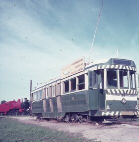
... No. 39 and D3 671 at Brown's Waterhole Park Lismore...Set of two Colour 27 x 27 mm slides in Agfachrome blue and white plastic mounts of Ballarat tram No. 39 and D3 671 at Brown's Waterhole Park Lismore c1972. Note: The locomotive is showing remaining at the park during 2009 - see vicsig.net accessed 15-9-2016 Photo from the collection of Lilian Butler. ...No. 39 and D3 671 at Brown's Waterhole Park Lismore Slide 27 mm sq slide/s - set of 2 Lilian Butler ...Yields information about the appearance of tram No. 39 at Lismore after being placed there.Set of two Colour 27 x 27 mm slides in Agfachrome blue and white plastic mounts of Ballarat tram No. 39 and D3 671 at Brown's Waterhole Park Lismore c1972. Note: The locomotive is showing remaining at the park during 2009 - see vicsig.net accessed 15-9-2016 Photo from the collection of Lilian Butler. See also Reg Item 6605 for another set of photographs after the tram has had a shelter built over it.ballarat, tramways, trams, preserved trams, lismore, railway locomotives, tram 39 -
 Eltham District Historical Society Inc
Photograph, "Summer Waterhole" - Peter Glass, 1971
... "Summer Waterhole" - Peter Glass...Significant light flare is reflected off glossy surface of original work at camera lens at lower left and right sides causing quality issues. "Summer Waterhole" - Peter Glass Photograph ...Reproduced page 48 of Pioneers & Painters, edited by Alan Marshall (1971) Source: Sydney Cooke Chemical Pty LtdThis photo forms part of a collection of photographs gathered by the Shire of Eltham for their centenary project book,"Pioneers and Painters: 100 years of the Shire of Eltham" by Alan Marshall (1971). The collection of over 500 images is held in partnership between Eltham District Historical Society and Yarra Plenty Regional Library (Eltham Library) and is now formally known as the 'The Shire of Eltham Pioneers Photograph Collection.' It is significant in being the first community sourced collection representing the places and people of the Shire's first one hundred years.4 x 5 inch colour reversal film (1) Condition: May not be true to colour of original work. Scanned from a 4 x 5 inch colour transparency which was taken c.1970 (approx. 50 years old) and which has undergone significant colour degradation towards the red spectrum. Allowances made for colour cast correction in scan with best guess for white balance. Significant light flare is reflected off glossy surface of original work at camera lens at lower left and right sides causing quality issues. artist, pioneers and painters, sepp, shire of eltham pioneers photograph collection, peter glass -
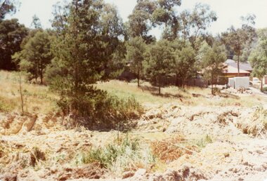
 Ringwood and District Historical Society
Photograph, Remains of a waterhole on the top of the hill north of Kubis Drive, North Ringwood in 1977
... Remains of a waterhole on the top of the hill north of Kubis Drive, North Ringwood in 1977...The developer, Mr Kubis, named streets after his family and associates. Remains of a waterhole on the top of the hill north of Kubis Drive, North Ringwood in 1977 Photograph ...Part of a 101-photo record of the development of the "Bel Air" Estate, Ringwood North, including road works to Debbie Place, Kubis Drive, Jenkins Close, Burlock Avenue, Pamela Court, Manuelo Terrace, Lyn Court, Rudolf Court, Werac Drive, Iluka Place and Glenvale Road. From the Jack Lundy Clarke collection (39 Burlock Avenue, North Ringwood) of photos taken from 1976 to 1982. The developer, Mr Kubis, named streets after his family and associates.With Stephen and Peter Clarke -
 Nillumbik Shire Council
Painting: Lindsay EDWARDS (b.1991 - d.2007 Vic, AUS), Untitled (Central Australian Landscape with Waterhole)
... Untitled (Central Australian Landscape with Waterhole)...Nillumbik Shire Council melbourne Untitled (Central Australian Landscape with Waterhole) Painting: Lindsay EDWARDS (b.1991 - d.2007 Vic, AUS) ... -
 Federation University Art Collection
Painting - Oil on canvas, Sydney Pern, Waterhole by Sydney Pern
... Waterhole by Sydney Pern...Pern' Framed oil landscape on oil sketching paper. Waterhole by Sydney Pern Painting Oil on canvas Sydney Pern ...Dr Sydney PERN (c1879- 23 October 1967 ) Sydney Pern was a doctor who practiced in Ballarat. He was a competent artist who also collected Aboriginal artefacts. This item is part of the Federation University Art Collection. The Art Collection features over 2000 works and was listed as a 'Ballarat Treasure' in 2007.Framed oil landscape on oil sketching paper.signed lower right 'S. Pern'art, artwork, sydney pern, pern, landscape, available -
 Ringwood and District Historical Society
Photograph, The waterhole under Kubis Drive, North Ringwood just north of the bend in Jan 1978
... The waterhole under Kubis Drive, North Ringwood just north of the bend in Jan 1978...The developer, Mr Kubis, named streets after his family and associates. The waterhole under Kubis Drive, North Ringwood just north of the bend in Jan 1978 Photograph ...Part of a 101-photo record of the development of the "Bel Air" Estate, Ringwood North, including road works to Debbie Place, Kubis Drive, Jenkins Close, Burlock Avenue, Pamela Court, Manuelo Terrace, Lyn Court, Rudolf Court, Werac Drive, Iluka Place and Glenvale Road. From the Jack Lundy Clarke collection (39 Burlock Avenue, North Ringwood) of photos taken from 1976 to 1982. The developer, Mr Kubis, named streets after his family and associates. -
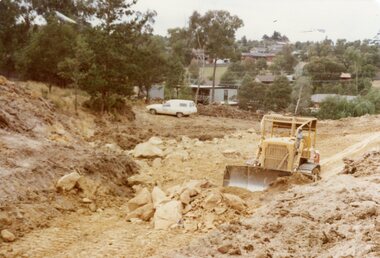 Ringwood and District Historical Society
Photograph, Filling the waterhole to provide Foundation for Kubis Drive, North Ringwood in Jan 1978
... Filling the waterhole to provide Foundation for Kubis Drive, North Ringwood in Jan 1978...The developer, Mr Kubis, named streets after his family and associates. Filling the waterhole to provide Foundation for Kubis Drive, North Ringwood in Jan 1978 Photograph ...Part of a 101-photo record of the development of the "Bel Air" Estate, Ringwood North, including road works to Debbie Place, Kubis Drive, Jenkins Close, Burlock Avenue, Pamela Court, Manuelo Terrace, Lyn Court, Rudolf Court, Werac Drive, Iluka Place and Glenvale Road. From the Jack Lundy Clarke collection (39 Burlock Avenue, North Ringwood) of photos taken from 1976 to 1982. The developer, Mr Kubis, named streets after his family and associates. -
 Hume City Civic Collection
Photograph
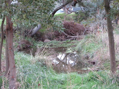
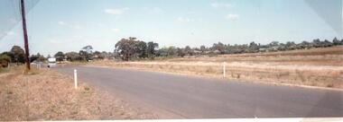
... A photo of Old Calder Highway in Diggers Rest with houses on one side and a manmade waterhole on the other side beside the railway line. ...A colour photograph of a waterhole on the side of the road and beside a railway line. ...Hume City Civic Collection 44 Macedon Street Sunbury melbourne A photo of Old Calder Highway in Diggers Rest with houses on one side and a manmade waterhole on the other side beside the railway line. ...A photo of Old Calder Highway in Diggers Rest with houses on one side and a manmade waterhole on the other side beside the railway line. The railway crossing can be seen in the background next to the railway station.A colour photograph of a waterhole on the side of the road and beside a railway line. It is unmounted.old calder highway, diggers rest, diggers rest railway station, railways, george evans collection -
 Orbost & District Historical Society
recipe book
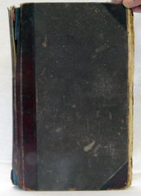
... inside cover - "Mrs J. Kennedy, Waterholes, Fernbank"...Orbost & District Historical Society Ruskin Street Orbost gippsland recipes domestic cookery inside cover - "Mrs J. Kennedy, Waterholes, Fernbank" A "Cash Book" being used as a recipe book. ...A "Cash Book" being used as a recipe book. The cover is brown / red / purple fabric. On the spine in gold print is "Cash Book". It contains hand-written recipes.inside cover - "Mrs J. Kennedy, Waterholes, Fernbank"recipes domestic cookery -
 Lakes Entrance Historical Society
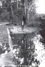
Photograph - Swamp Creek Buchan Road
... Boy on a bike standing by a waterhole...Boy on a bike standing by a waterhole Photograph Swamp Creek Buchan Road ...Black and white copy of a sepiaPostcard. Boy on a bike standing by a waterholeSwamp Creek Buchan Road -
Whitehorse Historical Society Inc.
Document, Waterholes Exhibition, 2013
... Catalogue of paintings and photographs of Waterholes in Whitehorse, displayed 11 September - 5 October 2013 at the Whitehorse Artspace....Waterholes Exhibition Document Document ...Catalogue of paintings and photographs of Waterholes in Whitehorse.Catalogue of paintings and photographs of Waterholes in Whitehorse, displayed 11 September - 5 October 2013 at the Whitehorse Artspace.Catalogue of paintings and photographs of Waterholes in Whitehorse.whitehorse artspace, blackburn lake, surrey dive box hill -
 Whitehorse Historical Society Inc.
Report, Abraham Rooks holding, ca 1870
... Inspection of Abraham Rook's holding of 80 acres including description of house, outhouse, fencing, waterhole, stable by the Crown Lands Bailiff...thompson robert rooks abraham land settlement Inspection of Abraham Rook's holding of 80 acres including description of house, outhouse, fencing, waterhole, stable by the Crown Lands Bailiff Abraham Rooks holding Report ...Inspection of Abraham Rook's holding of 80 acres including description of house, outhouse, fencing, waterhole, stable by the Crown Lands Bailiffthompson, robert, rooks, abraham, land settlement -
Lakes Entrance Historical Society
Map - County of Croajingolong, Department Lands and Survey, 1966
... Shows New South Wales Border, Wangarabell, Maramingo, Wau Wauka West, Princes Highway, Maramingo Creek, Sandy Waterhole Creek Camp Res....Waterways Roads Settlement Shows New South Wales Border, Wangarabell, Maramingo, Wau Wauka West, Princes Highway, Maramingo Creek, Sandy Waterhole Creek Camp Res. Map County of Croajingolong Department Lands and Survey ...Shows New South Wales Border, Wangarabell, Maramingo, Wau Wauka West, Princes Highway, Maramingo Creek, Sandy Waterhole Creek Camp Res.waterways, roads, settlement -
 Hume City Civic Collection
Photograph
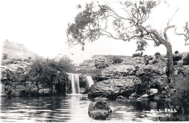
... A black and white photograph of a small waterfall cascading over rocks into a waterhole in Jacksons Creek. It is near the ruins of Eadies Flour Mill, Sunbury, just up from the sewerage treatment plant....Sunbury Waterworks now occupies the site. eadies flour mill jackson creek eadie peter waterfalls george evans collection A black and white photograph of a small waterfall cascading over rocks into a waterhole in Jacksons Creek. It is near the ruins of Eadies Flour Mill, Sunbury, just up from the sewerage treatment plant. ...Eadie's Mill on Jacksons Creek was one of the earliest mills to be established in the area. Sunbury Waterworks now occupies the site.A black and white photograph of a small waterfall cascading over rocks into a waterhole in Jacksons Creek. It is near the ruins of Eadies Flour Mill, Sunbury, just up from the sewerage treatment plant.eadies flour mill, jackson creek, eadie, peter, waterfalls, george evans collection -
 City of Kingston
Photograph - Black and white, c. 1944
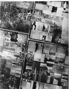
... Aerial photograph of Moorabbin, including Chesterville Road, Keys Road and Wickham Road, Moorabbin, Briggs cottage, Neill's waterhole, McKittrick property, site of FRUMEL...City of Kingston Parkdale Library 96 Parkers Road, Parkdale Parkdale Aerial photograph of Moorabbin, including Chesterville Road, Keys Road and Wickham Road, Moorabbin, Briggs cottage, Neill's waterhole, McKittrick property, site of FRUMEL Moorabbin City of Moorabbin Chesterville Keys Wickham Handwritten in red ink on reverseL A 603 / 97% [in red circle] Handwritten in blue ink on reverse: 9502 06111 / M'bbin Black and white aerial view of Moorabbin. ...Aerial photograph of Moorabbin, including Chesterville Road, Keys Road and Wickham Road, Moorabbin, Briggs cottage, Neill's waterhole, McKittrick property, site of FRUMELBlack and white aerial view of Moorabbin. Houses, market garens, roads, and water features are all clearly visible.Handwritten in red ink on reverseL A 603 / 97% [in red circle] Handwritten in blue ink on reverse: 9502 06111 / M'bbinmoorabbin, city of moorabbin, chesterville, keys, wickham -
 Bendigo Historical Society Inc.
Map - MAP - THE INFANCY OF BENDIGO - GOLDEN SQUARE IN 1851
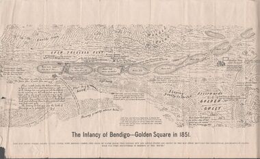
... Map shows the chain of waterholes, Golden Gully, hill and bush areas and open treeless flat. ...Map shows the chain of waterholes, Golden Gully, hill and bush areas and open treeless flat. ...Hand-drawn map of Bendigo - Golden Square in 1851. Map shows the chain of waterholes, Golden Gully, hill and bush areas and open treeless flat. Mentioned on the map are places where there were mia mias, stockyards, Gibson & Fenton's butchery & First Store.map, bendigo, goldfields, map the infancy of bendigo & golden square 1851, capt dane, william johnson, mrs kennedy, mrs farrell, ben hall, chris asquith, gibson & fenton's butchery & first store, p odonnell, walter r sandbach, william sandbach, mr frencham, john ross, thos myers, bendigo hut & little stockyard, commissioner horne, j jones, c cohen -
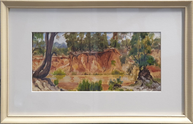
 South Gippsland Shire Council
Painting, Watercolour, Late Afternoon
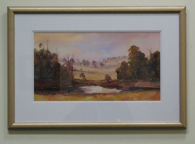
... Features a country scene of trees, low hills, and a waterhole or dam. Painted in colours of browns, creams and yellows. ...Features a country scene of trees, low hills, and a waterhole or dam. Painted in colours of browns, creams and yellows. ...Framed watercolour titled "Late Afternoon" painted by Julie Lundgren Coulter. Features a country scene of trees, low hills, and a waterhole or dam. Painted in colours of browns, creams and yellows. Gold frame with triple cream card mount. On reverse is a name and address label of the artist & the text: "PEACE IS SEEKING A SUNSET & KNOWING WHO TO THANK""PEACE IS SEEKING A SUNSET & KNOWING WHO TO THANK" -
 Lake Bolac & District Historical Society
Black and white photograph, "Narrapumelap", Wickliffe
... The aboriginal meaning of Narrapumelap is a chain of waterholes. Begun in 1873 by John Dixon Wyselaskie and completed in 1878. ...The aboriginal meaning of Narrapumelap is a chain of waterholes. Begun in 1873 by John Dixon Wyselaskie and completed in 1878. ..."Narrapumelap" homestead, Wickliffe. The aboriginal meaning of Narrapumelap is a chain of waterholes. Begun in 1873 by John Dixon Wyselaskie and completed in 1878. The new owner in 1883 was Gerald Neville Buckley, son of Mr Mars Buckley, founder of Buckley and Nunn LTD, who 'enhanced' the building. The property was acquired for by the government in 1914 and later split up for Soldier Settlement.wickliffe, "narrapumelap, buckley, buckley and nunn, wyselaskie, soldier settlement -
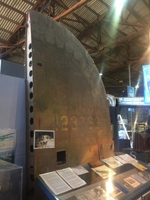 B-24 Liberator Memorial Restoration Australia Inc
Tail Plane from 'Little Eva' crash, Circa 1941/2
... Crashed near Burriejell waterhole at Moonlight Creek, Escott Station in far north Queensland on 2 December 1942. ...Crashed near Burriejell waterhole at Moonlight Creek, Escott Station in far north Queensland on 2 December 1942. ...Commemoration of the crash of USAAF B-24 Liberator #41-23762 'Little Eva' of the 321st Squadron, 90th Bombardment Group based at Iron Range. Crashed near Burriejell waterhole at Moonlight Creek, Escott Station in far north Queensland on 2 December 1942. Two of the ten crewmen were rescued by the manager of Escott Station after 13 days of deprivation.2bxThe tail plane/fin from the crash site of Liberator 'Little Eva'. This site is registered as Doomadgee Queensland Australia, approximate GPS Co-ordinates: Latitude -17 56 24 Longitude +138 49 47.Faded USAAF Insignia 41-23762little eva, 4123762, usaaf -
Dandenong & District Historical Society
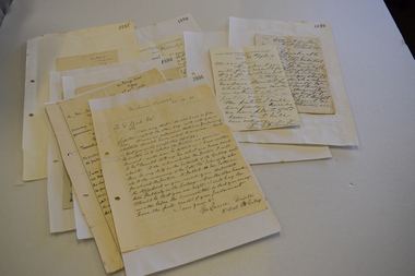
Bourke Family, John Conway Bourke - Enquiry Letter and Thank-you Letter
... ...Waterhole...Dandenong & District Historical Society 1st Floor, 39 Clow Street Dandenong melbourne John Conway Bourke - Enquiry Letter and Thank-you Letter John Conway Bourke John Bourke John Bourke Water Holes Alfred Langhorne Joseph Hawdon Waterhole Cath Dowling (grand-daughter of John Conway Bourke) Eumemmerring Creek Water Holes John Conway Bourke - Enquiry Letter and Thank-you Letter John Conway Bourke - Enquiry Letter and Thank-you Letter Bourke Family ...John Conway Bourke - Enquiry Letter and Thank-you Letterjohn conway bourke, john bourke, john bourke water holes, alfred langhorne, joseph hawdon, waterhole, cath dowling (grand-daughter of john conway bourke), eumemmerring creek water holes -
Clunes Museum
Tool - GOLD CRADLE & PANNING DISH, JAMES ESMOND, CIRCA 1850
... THE CRADLE OR BANJO IS USUALLY SET UP AT RIGHT ANGLES TO A SHALLOW CREEK OR WATERHOLE WITH THE OPEN ENDS TOWARDS THE WATER...THE CRADLE OR BANJO IS USUALLY SET UP AT RIGHT ANGLES TO A SHALLOW CREEK OR WATERHOLE WITH THE OPEN ENDS TOWARDS THE WATER LOCAL HISTORY MINING EQUIPMENT MINING .1 WOODEN CONSTRUCTION MADE BY HAND WITH GAUZE FILTER IN UPPER SECTION TO SEPARATE QUARTZ ROCKS, SAND AND SOIL. ...USED TO OBTAIN ALLUVIAL GOLD THE DESIGN OF THIS EQUIPMENT IS MOSTLY BASED ON THE PRINCIPLE OF THE WAY HEAVY MINERALS ARE CONCENTRATED IN ALLUVIAL DEPOSITS. THE PROSPECTING DISH IS USED WHEN WORKING WITH SMALL AMOUNTS OF STONES & CLAY WHILE BIGGER JOBS THE CRADLE OR BANJO IS MORE EFFICIENT. THE GAUZE OF MESH IN THE SIEVE IS VARIABLE. THE CRADLE OR BANJO IS USUALLY SET UP AT RIGHT ANGLES TO A SHALLOW CREEK OR WATERHOLE WITH THE OPEN ENDS TOWARDS THE WATER.1 WOODEN CONSTRUCTION MADE BY HAND WITH GAUZE FILTER IN UPPER SECTION TO SEPARATE QUARTZ ROCKS, SAND AND SOIL. A HANDLE ON BOX LIKE CONSTRUCTION IS USED TO ROCK THE CRADLE WHICH IS MOUNTED WITH ITS ROCKERS RESTING ON WOODEN BEARERS. .2 PANlocal history, mining equipment, mining -
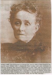 Bendigo Historical Society Inc.
Newspaper - JENNY FOLEY COLLECTION: A FULL LIFE
... Sarah drowned in October 1854, in a waterhole at Maiden Gully. Annie married Louis Searle in 1871 and went on to have 14 children. ...Sarah drowned in October 1854, in a waterhole at Maiden Gully. Annie married Louis Searle in 1871 and went on to have 14 children. ...Bendigo Advertiser "The way we were" from Wednesday, October 6, 2004. A full life: this photograph is of Annie Carr, born in 1849 in New Zealand. Her parents were William Carr, a blacksmith from London and Jane Jamieson of Kilbirnie, Scotland. She arrived in Sandhurst in June, 1854 with her parents and her sister Sarah. Sarah drowned in October 1854, in a waterhole at Maiden Gully. Annie married Louis Searle in 1871 and went on to have 14 children. Annie died at Northcote in 1922.newspaper, bendigo advertiser, the way we were -
Federation University Historical Collection
Document, Articles on the Bunyip, 1983 - 1989
... The bunyip is a large mythical creature from Aboriginal mythology, said to lurk in swamps, billabongs, creeks, riverbeds, and waterholes. The origin of the word bunyip has been traced to the Wemba-Wemba or Wergaia language of Aboriginal people of South-Eastern Australia. ...Barker Library (top floor) Mount Helen goldfields The bunyip is a large mythical creature from Aboriginal mythology, said to lurk in swamps, billabongs, creeks, riverbeds, and waterholes. The origin of the word bunyip has been traced to the Wemba-Wemba or Wergaia language of Aboriginal people of South-Eastern Australia. ...The bunyip is a large mythical creature from Aboriginal mythology, said to lurk in swamps, billabongs, creeks, riverbeds, and waterholes. The origin of the word bunyip has been traced to the Wemba-Wemba or Wergaia language of Aboriginal people of South-Eastern Australia. However, the bunyip appears to have formed part of traditional Aboriginal beliefs and stories throughout Australia, although its name varied according to tribal nomenclature. Various written accounts of bunyips were made by Europeans in the early and mid-19th century, as settlement spread across the country. (http://en.wikipedia.org/wiki/Bunyip) This material was collected and used for resarch purposes by David Waldron A number of articles on the Bunyip * The Nessie Mystery Solver by Roy Fraser (October 1983) * Developers meet match (Wagyl) (The Age, 06 Jan 1989) * Narrandera's bunyips burst into tourism's limelight by Melanie Sincock (wagga Advertiser, 18 November 1986) * Hunting the bunyip by M.A. Troyahn (Australiasian Post, 06 October 1883) * Beware the bunyip, you Moomba skiers by Edel Wignell (The Age, 05 March 1982) * The yarn that grew the bunyip legend (Australasian Post, 30 December 1971) australian animal folklore collections, bunyip, bunyipswagyl, shane picket, narrandera, swan river, david waldron -
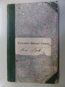 Warrnambool and District Historical Society Inc.
Document - Ledger, Warrnambool Municipal Common, Circa 1865
... Entries relate to items such as eradication of thistles, repairs and erection of stock yards, burying of dead stock, purchase of bulls and clearing of waterholes. Salaries were paid to E. Margetts, D Allan, T Raingill, and M T Read. ...Entries relate to items such as eradication of thistles, repairs and erection of stock yards, burying of dead stock, purchase of bulls and clearing of waterholes. Salaries were paid to E. Margetts, D Allan, T Raingill, and M T Read. ...This cash book contains entries which relate to the everyday operation of the Borough Common which predates the establishment of Warrnambool as a town. All ratepayers had the right to graze their cows on the common, with the cows being collected every morning by the herdsman and walked to the common. Entries relate to items such as eradication of thistles, repairs and erection of stock yards, burying of dead stock, purchase of bulls and clearing of waterholes. Salaries were paid to E. Margetts, D Allan, T Raingill, and M T Read. Auditors were James Dickson. After WW1 parts of the common were allocated to soldiers’ settlement blocks ranging from 18 to 30 acres. Other parts remained with the Crown for Municipal uses and part became the Warrnambool Golf Course. In 1925 the common was abolished.The entries in this book record the operations and earliest residents who were involved in the Common in the early days of WarrnamboolGrey and red mottled card cover with dark green points and spine. Paper label on front cover. Dark blue and tan mottled paper inside front and back covers. Warrnambool Municipal Common Cash Book.warrnambool borough, warrnambool common, e margetts, raingill, d allan, m t read, warrnambool common cash book -
 Warrnambool and District Historical Society Inc.
Correspondence – Louis Buvelot, 1889-1897
... The other eight letters were written between 1889 and 1897 and document the controversy of the time when the authenticity of the art work by Louis Buvelot, The Waterhole at Coleraine, in the Warrnambool Art Gallery collection, was questioned. ...The other eight letters were written between 1889 and 1897 and document the controversy of the time when the authenticity of the art work by Louis Buvelot, The Waterhole at Coleraine, in the Warrnambool Art Gallery collection, was questioned. ...One of these items is an 1894 letter written by the artist Tudor St George Tucker regarding one of his artworks in the Warrnambool Art Gallery collection. The other eight letters were written between 1889 and 1897 and document the controversy of the time when the authenticity of the art work by Louis Buvelot, The Waterhole at Coleraine, in the Warrnambool Art Gallery collection, was questioned. The Warrnambool photographer Daniel Clarke was querying the authenticity of the art work in the Art Gallery but evidence in the form of letters from George Folingsby of the National Gallery in Melbourne and from Louis Buvelot’s widow, Caroline-Julie, confirmed that there was confusion over the number of art works that Buvelot had executed with a similar theme. It was eventually proven that the Buvelot art work was genuine. The public spat was largely played out in the Warrnambool Standard but these original letters fill in the gaps of our knowledge on the subject. The letters came into the possession of George Lance who was involved with the Warrnambool Mechanics Institute /Art Gallery in the 1880s and 1890s and was the secretary of these institutions from 1892 to 1901. The letters were then handed on George Lance’s grandson, Bruce Morris, a well-known Warrnambool historian who was the editor of the Warrnambool Standard from 1946 to 1968. These letters are of great significance as eight of them are the original letters written in connection with the 19th century controversy in Warrnambool over the authenticity of a Louis Buvelot art work owned by the Warrnambool Art gallery. .1 A sheet of paper folded in two containing three pages of writing handwritten in black ink and pasted on paper. .2 A sheet of paper folded in two containing one page of writing handwritten in black ink and pasted on a sheet of paper. .3 A sheet of paper with handwriting in black ink pasted on a piece of paper. .4 One sheet of paper folded in two to make four pages of writing, handwritten in black ink. .5 .6 .7 A sheet of paper with handwritten material in black ink pasted onto another sheet of paper .8 A sheet of paper folded in two with three pages of handwritten material pasted onto another sheet of paper. .9 A sheet of paper folded in two with one page of handwritten material pasted onto another sheet of paper. tudor st. george tucker, artist, louis buvelot, artist, george lance, warrnambool, daniel clarke, warrnambool, george folinsby, melbourne, history of warrnambool -
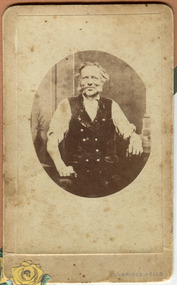 City of Moorabbin Historical Society (Operating the Box Cottage Museum)
Photograph, black & white George Box 1808- 1867, c1855
... Mary suffered from headaches and had occasional fits and the coroner found she passed out and died while trying to ease the pain with cold water from a waterhole. It is supposed that Elizabeth helped him raise the children while he established his market garden. ...Mary suffered from headaches and had occasional fits and the coroner found she passed out and died while trying to ease the pain with cold water from a waterhole. It is supposed that Elizabeth helped him raise the children while he established his market garden. ...George Box 1808-1867 an 'agricultural labourer', of Sussex England, married Mary Cripps in 1831 and with 3 three of their 4 four sons and 3 three of their 4 four daughters left Liverpool in the Sailing Ship 'Atlanta' in March 1856 to begin a new life in Melbourne, Victoria , Australia. George and son Henry paid their own fares while sons , Francis and John, were 'assisted passengers'. Their baby daughter Cecilia Lydia died a few days into the voyage.. Caroline Box, the eldest daughter, remained in England working as a cook until she joined the family in Australia in 1863. William Box 1834-1902, the eldest son of George Box, married Elizabeth Avis 1833- 1914 and they resided in Box Cottage 1865 -1914 where they established a market garden and raised 13 children. William and Elizabeth had emigrated in 1854 so George and sons probably worked on their market garden before setting up in Tucker Road and Patterson Road. Sadly Mary drowned in a water hole only 4 months after their arrival in Brighton. Mary suffered from headaches and had occasional fits and the coroner found she passed out and died while trying to ease the pain with cold water from a waterhole. It is supposed that Elizabeth helped him raise the children while he established his market garden. George died from Tetanus following an infected broken leg caused by falling from his dray in 1867. George and Mary were both buried in the Brighton Cemetery. Box Cottage Museum, a reconstruction of an early settler hut, is named after the Box family who resided there 1865 -1913 . George Box was the father of William Box who with his wife Elizabeth Avis Box and 13 children lived and farmed on the block of land in Jasper Road, East Brighton ( now McKinnon / Ormond) that was part of the Henry Dendy Special Survey 1841 Inscribed in Album : “ The early photos in this album were found by Mr (Laurie) Lewis when he was demolishing the Old Box Cottage. He gave them to Mrs Avis Box Eldridge who in turn gave them to me. They were not identified. I believe they rightly belong in the Cottage. I have attempted to identify them and present them in a way they can be preserved as a historical record of the era.” A B Leigh A black and white photograph of George Box taken in Tunbridge Wells, England c1855Photo at base ; TUNBRIDGE WELLS Album inside cover ; Donated to / Moorabbin / Historical Society / by / Avis Box Leigh box george, box mary, box william, box elizabeth, box alonzo, box mary louisa, dendy henry, were j b, dendy's special survey 1841, brighton, moorabbin, bentleigh, mckinnon, ormond, market gardeners, dairy farms, early settlers, pioneers, jasper road, gurr jabez, gurr eliza, pay henry, pay anna, ward willam, box henry, ward elizabeth emma, box john, sheldrake martha, rushall eleanor, box caroline, tetanus