Showing 9 items matching "waterproof map"
-
 Bendigo Military Museum
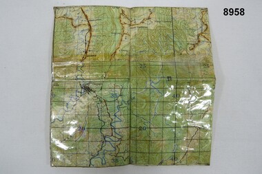
Map - WATERPROOF MAP, Unknown
... WATERPROOF MAP......Waterproof map...Small waterproof map of the location of the Australian jungle Training Camp at Canungra, Qld....Map WATERPROOF MAP ...Small waterproof map of the location of the Australian jungle Training Camp at Canungra, Qld.Grid lines and map reference numbers.passchendaele barracks trust, waterproof map -
 Bendigo Military Museum
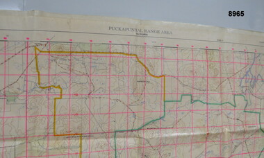
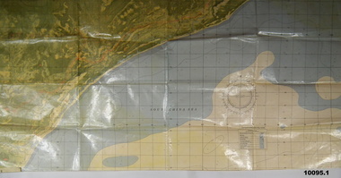
Map - MAP - PUCKAPUNYAL RANGE AREA, Royal Australian Survey Corps, Bendigo, 1958
... Large waterproof map of Puckapunyal Range area compiled by the Royal Australian Suurvey Corps in 1958 detailing Reference locations in and around Puckapunyal area....First Edition. Large waterproof map of Puckapunyal Range area compiled by the Royal Australian Suurvey Corps in 1958 detailing Reference locations in and around Puckapunyal area. ...Military Survey, First Edition 1958.Large waterproof map of Puckapunyal Range area compiled by the Royal Australian Suurvey Corps in 1958 detailing Reference locations in and around Puckapunyal area.Puckapunyal Range Area Military Survey Australia 1.25,000. First Edition.passchendaele barracks trust, pbt?, military map -
 Rye RSL Sub Branch
Map Trench waterproofed cloth
... A waterproofed cloth trench map of the Becelaere area, including Polygon Wood and other severely contested areas....Map Trench waterproofed cloth ...A waterproofed cloth trench map of the Becelaere area, including Polygon Wood and other severely contested areas. -
 National Vietnam Veterans Museum (NVVM)
Map
... Highly detailed map of Vietnam on parchment from Fwouc Tho Province. Map is waterproof....National Vietnam Veterans Museum (NVVM) 25 Veterans Drive Newhaven phillip-island-and-the-bass-coast Map Peter Lewis Highly detailed map of Vietnam on parchment from Fwouc Tho Province. Map is waterproof. Map Map ...Highly detailed map of Vietnam on parchment from Fwouc Tho Province. Map is waterproof.map, peter lewis -
 Bendigo Military Museum
Map - AIR PHOTO MAP & HOLDER, 1962 - 1972
... Overlaid on the air photo is - Principal height contours, Highway marked in red, names of villages and waterways and coastal depth soundings in fathoms. The map has a waterproof cover. 2. Map case, canvas khaki, it also has a Bakelite sheet backboard and a celluloid cover sheet. ...Overlaid on the air photo is - Principal height contours, Highway marked in red, names of villages and waterways and coastal depth soundings in fathoms. The map has a waterproof cover. 2. Map case, canvas khaki, it also has a Bakelite sheet backboard and a celluloid cover sheet. on the back board are 4 steel clips to hold the folded map. ...The Phuoc Tuy Border is about 58 kms E,S,E, from Ving Tau.1. Air photo of part of Phuoc Tuy Province, Sun. Overlaid on the air photo is - Principal height contours, Highway marked in red, names of villages and waterways and coastal depth soundings in fathoms. The map has a waterproof cover. 2. Map case, canvas khaki, it also has a Bakelite sheet backboard and a celluloid cover sheet. on the back board are 4 steel clips to hold the folded map. The case is held shut with brass press studs. The case has a khaki webbing strap affixed with brass fittings. 3. China graph pencil, yellow. Made by Staedtler and it is also embossed Commonwealth of Australia.1. The number “12” is written in numerous places. 2. On rear of case is some letters “O.C. HART .........? 1942” On the celluloid are some blue markings - looks like a house layout.vietnam war, map, map case -
 Bendigo Military Museum
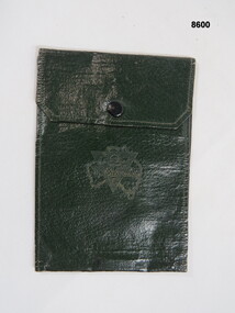
Equipment - WALLET, Unknown
... Green waterproof wallet, two inside pockets, brass press clip broken. A triangle shape over the map of Australia on front with inscription....Bendigo Military Museum 37 - 39 Pall Mall Bendigo goldfields Passchendaele Barracks Trust Wallet Waterproof Equipment On triangle & map of Australia, "Talk clean, live clean, fight clean, play the game." ...Green waterproof wallet, two inside pockets, brass press clip broken. A triangle shape over the map of Australia on front with inscription.On triangle & map of Australia, "Talk clean, live clean, fight clean, play the game."passchendaele barracks trust, wallet, waterproof, equipment -
 Bendigo Military Museum
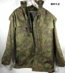
Uniform - JACKET, WATERPROOF, Equipage Clothing Co
... waterproof. Australian Camouflage pattern, Appears to be a coated Japara. Has a hood. Front is secured with both a zip and press studs. Long sleeved. Large pockets on front shoulders. Has a separate RAM cover. There is a zipped map...waterproof. Australian Camouflage pattern, Appears to be a coated Japara. Has a hood. Front is secured with both a zip and press studs. Long sleeved. Large pockets on front shoulders. Has a separate RAM cover. There is a zipped map ...Refer Cat 8607.5 re David Fields.1. Jacket - waterproof. Australian Camouflage pattern, Appears to be a coated Japara. Has a hood. Front is secured with both a zip and press studs. Long sleeved. Large pockets on front shoulders. Has a separate RAM cover. There is a zipped map pocket on right chest. 2. Liner, coat cold. Jungle green colour, long sleeved. Has press stud tabs for securing in Jacket.1. Written on label is "+ASM FIELD" 2. WRITTEN ON LINER LABEL IS "ASM".passchendaele barracks trust, aust army uniform, waterproof jacket -
 Flagstaff Hill Maritime Museum and Village
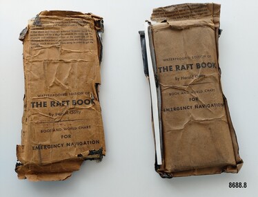
Booklet - Book and World Chart for Emergency Navigation, George Grady Press, The Raft Book, 1943
... The original book was 152 pages long however a condensed version was made which consisted of a 64 page booklet, combined map and star chart and calendar strip enclosed in a waterproof slipcase, to be placed in life rafts for emergency use. ...waterproof coverings (oiled paper) titled "The Raft Book" by Harold Gatty. Each packet contains a folded 64 page paper booklet with detailed instructions for navigating a small craft in open seas, a folded chart (with a map of the world and oceans, well known constellations, latitude and longitude charts, Greenwich time and a scale for string lengths and Harp scale) and a long folded paper calendar strip....The original book was 152 pages long however a condensed version was made which consisted of a 64 page booklet, combined map and star chart and calendar strip enclosed in a waterproof slipcase, to be placed in life rafts for emergency use. ...Harold Gatty was born on January 5th, 1903 in Campbell Town, Tasmania. He was a navigator and aviation pioneer. He began his career learning navigation at the age of 14 as a midshipman at the Royal Australian Naval College but withdrew after three years and became an apprenticed ship's officer with the Patrick Steamship Company of Sydney. After W. W. 1 he joined the Australian Merchant Navy where he learned the constellations while standing night watch and became an expert in celestial navigation while serving on many ships sailing between Australia and California. In 1927 he moved to California and opened a navigation school and also a laboratory repairing navigational equipment. At this time he became very interested in air navigation and was aware of the limitations of existing methods and instruments for aerial navigation. He began researching ways of improving aerial navigation. Two early inventions of his were his air sextant and a ground speed and drift indicator which formed the basis of the automatic pilot which later came to be standard equipment on most aircraft. He worked with several record breaking pilots including Ann Morrow Lindbergh (who went on to serve as a navigator for her husband Charles Lindbergh), helped Wiley Post break the world record circumnavigating the Earth, invented a new method of "dead reckoning" that revolutionised the ability to fly safely through cloudy conditions without drifting off course and famously navigated a small plane (whilst trying to cross the Pacific) over 1900 km through fog (with no radio) and using only his dead reckoning techniques, back to their starting point in Japan after they developed fuel problems. In 1932 Gatty received the Distinguished Flying Cross from President Hoover. In 1934 Gatty formed the South Seas Commercial Company with Donald Douglas with the aim to deliver air services to the islands of the South Pacific. The Company was sold to Pan Am but he continued to work for them. In 1935 he went on a sailing expedition investigating several small islands in the South Pacific and was briefly marooned on Baker Island. He was able to use his extensive knowledge of seabird habits to save the crew. He was also very interested in the ability of the Polynesians to navigate using the stars. During the Second World War Gatty was given the honorary rank of Group Captain in the Royal Australian Air Force (RAAF) and worked for the U. S. Army Air Forces (USAAF) in the South Pacific. In 1943 he moved to Washington where he developed a survival book (The Raft Book) specifically for boat crews or air crews flying over the Pacific to help them survive and navigate their life rafts in remote areas of the ocean. The original book was 152 pages long however a condensed version was made which consisted of a 64 page booklet, combined map and star chart and calendar strip enclosed in a waterproof slipcase, to be placed in life rafts for emergency use. The booklet included navigational advice and ideas such as ocean currents, estimation of distance, using a compass, measurement of angles, recognising and steering by the stars, land indications from sea birds, migration of sea birds and insects, sounds from the land, the scent of the land and ocean currents and the colour of the sea etc. After W.W.2 Gatty moved to Fiji and formed Fiji Airways (which later became Air Pacific). Harold Gatty died in August 1957.The two copies of "The Raft Book" are significant as they are a written summary of the many methods of sea navigation (both modern and historical) that existed in the 1940's. They are also a record of Harold Gatty, who played a significant role in the development of modern day aerial navigation using his understanding of different sea navigational techniques.Two rectangular brown packets with waterproof coverings (oiled paper) titled "The Raft Book" by Harold Gatty. Each packet contains a folded 64 page paper booklet with detailed instructions for navigating a small craft in open seas, a folded chart (with a map of the world and oceans, well known constellations, latitude and longitude charts, Greenwich time and a scale for string lengths and Harp scale) and a long folded paper calendar strip.Front of package - "WATERPROOFED EDITION OF/ THE RAFT BOOK / By Harold Gatty / BOOK AND WORLD CHART / FOR / EMERGENCY NAVIGATION / To open envelope tear along above line. If the envelope is used again fold the flap to keep contents dry. 1. This envelope contains a book, chart and tape for emergency navigation. The contents are folded to take up the least possible space and therefore should not be removed until needed. 2. if the chart and tape are immersed in water for a long period, there will be a slight variation in the scale but the strength and resistence to tear of the paper will not be changed. In the event of long immersion, dry the chart and tape as much as possible before using in order to in order to get the greatest accuracy in scale. Front of booklet - THE RAFT BOOK / LORE OF THE SEA AND SKY /By Harold Gatty IMPORTANT FOR YOUR SECURITY/Upon abandoning ship you may have to be your own navigator. Take the following pre/cautions for your own safety:/ Carry a good type of pocket watch / keep it wound and have it running on Greenwich (England) / Time, which you can get from the navigating officer. / Keep track of the date at Greenwich; and on a 24-hour basis, / know whether the time is, say, 6 hours (6 A.M.) showing on / your watch, or 18 hours (6P.M.) Greenwich. / PROECT YOUR WATCH. GET A RUBBER SACK FOR IT (OBTAIN FROM PHARMACIST) AND KEEP IT DRY / KEEP A PENCIL IN YOUR POCKET/ POSITION OF SHIP WHEN ABANDONED PRINTED IN UNITED STATES OF AMERICA GEORGE GRADY PRESS, NEW YORK/COPYRIGHT, 1943, BY HAROLD AND FENNA GATTYflagstaff hill maritime museum and village, shipwreck coast, warrnambool, the raft book, harold gatty, book and world chart for emergency navigation, ww 2, ww ii, navigation, air navigation, aerial navigation, lindbergh, wiley post, dead reckoning, south seas commercial company, u.s. army airforce, usaaf, survival book, life rafts, sea navigation, emergency navigation, fiji airways, harp scale -
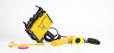 Department of Energy, Environment and Climate Action
Equipment - Criterion Survey Laser
... waterproof paper. The Statewide Forest Resource Inventory (SFRI) project began in 1993 and followed a few years after the release Timber industry Strategy. The aim was to bolster the existing 1:25000 scale mapping and improve the accuracy of the volume and growth estimates for the forest estate. This scary looking gadget looks like a speed radar used by the cops. The LTI Criterion Survey Laser and Rangefinder was a powerful instrument that could measure and record tree height, diameter at any visible point up the tree and branch take-off points. It was used to identify and map...waterproof paper. The Statewide Forest Resource Inventory (SFRI) project began in 1993 and followed a few years after the release Timber industry Strategy. The aim was to bolster the existing 1:25000 scale mapping and improve the accuracy of the volume and growth estimates for the forest estate. This scary looking gadget looks like a speed radar used by the cops. The LTI Criterion Survey Laser and Rangefinder was a powerful instrument that could measure and record tree height, diameter at any visible point up the tree and branch take-off points. It was used to identify and map ...There had been timber assessments in Victorian State forests since the late 1920s, coinciding with arrival of the three Norwegian foresters. The program was accelerated during the post-war housing boom. It was driven by the push eastwards away from the Central Highlands to find timber resources after the 1939 bushfire salvage was completed. Spending time in the field with assessment branch was a “rite of passage” for many young forestry graduates leaving Creswick. The work was arduous, and measurements were taken with simple and robust equipment like Gunters chains, prismatic compass, Abney levels, barometers and clinometers. Data was recorded by hand onto waterproof paper. The Statewide Forest Resource Inventory (SFRI) project began in 1993 and followed a few years after the release Timber industry Strategy. The aim was to bolster the existing 1:25000 scale mapping and improve the accuracy of the volume and growth estimates for the forest estate. This scary looking gadget looks like a speed radar used by the cops. The LTI Criterion Survey Laser and Rangefinder was a powerful instrument that could measure and record tree height, diameter at any visible point up the tree and branch take-off points. It was used to identify and map tree faults such as branches, scars and knots and to calculate tree taper functions. When used correctly, it has an accuracy of better than 1% for height and diameter. It could also measure survey information such as asmuth, distance and elevation. It was expensive back in the day (more than $20,000) - this one was manufactured in 1996 - and heavy. This item was donated to the Beechworth museum by Peter Black in 2015 and is now at Altona and recorded in Victorian Collections Criterion Survey Laser with box and batteryLaser Technology Inc, Englewood, Colorado, USAsurveying, forest measurement