Showing 17 items matching "weather bureau"
-
 Federation University Historical Collection
Document - Document - Letter, Ballarat Junior Technical School: Letters relating to equipment to establish a practice weather-observation station. 1952
... ...weather bureau...The glassware for the Regnault Vapour pressure Apparatus not previously sent has been forwarded. .2: Letter from the school to The Director Weather Bureau Melbourne. Outlines establishing a weather-observing station as part of general science. ...The glassware for the Regnault Vapour pressure Apparatus not previously sent has been forwarded. .2: Letter from the school to The Director Weather Bureau Melbourne. Outlines establishing a weather-observing station as part of general science. ....1: Letter from H B Selby & Co Pty Ltd re the order for a Fortin Barameter. Asking for arrangement for Staff member to collect as it is very fragile. The glassware for the Regnault Vapour pressure Apparatus not previously sent has been forwarded. .2: Letter from the school to The Director Weather Bureau Melbourne. Outlines establishing a weather-observing station as part of general science. Mr McLachlin in Ballarat will guide the school as to method, procedure, records, etc List of equipment on loan - Stevenson Screen, maximum and minimum thermometers, wet and dry bulb thermometers, 8" rain gauge, cloud chart, instructions for reductions of barometer readings, weather code for transmission, record book. 2 Cream pages, typed .1: Letterhead for H B Selby & Co Pty Ltd - Black and red inks Signature of V T Parkinson, Managerballarat junior technical school, head master, l garner, h b selby, weather bureau, weather station, observations, fortin barameter, regnault vapour pressure apparatus, stevenson screen, maximum thermometer, minimum thermometer, bulb thermometers, rain gauge, instructions, weather code, record book -
 Lakes Entrance Historical Society
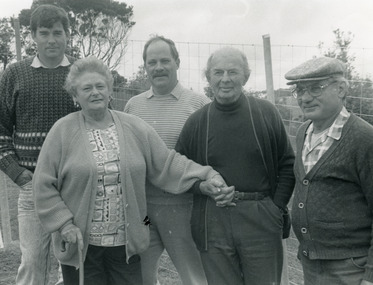
Photograph - Retirement of Barbara Ray , weather recorder Lakes Entrance 1992, Lakes Post Newspaper
... Black and white photograph of a group of people Peter Dawson Weather Bureau Inspector for Victoria, Graham Duff Regional Operations Manager for Weather Bureau, Barbara and Frank Ray, Tony Langiano taken on the occasion of the retirement of Barbara Ray after 27 years at the Victorian Bureau of Meteorology Weather Station Myers Street Lakes Entrance...Genealogy retirement Black and white photograph of a group of people Peter Dawson Weather Bureau Inspector for Victoria, Graham Duff Regional Operations Manager for Weather Bureau, Barbara and Frank Ray, Tony Langiano taken on the occasion of the retirement of Barbara Ray after 27 years at the Victorian Bureau of Meteorology Weather Station Myers Street Lakes Entrance Photograph Retirement of Barbara Ray , weather recorder Lakes Entrance 1992 Lakes Post Newspaper ...Black and white photograph of a group of people Peter Dawson Weather Bureau Inspector for Victoria, Graham Duff Regional Operations Manager for Weather Bureau, Barbara and Frank Ray, Tony Langiano taken on the occasion of the retirement of Barbara Ray after 27 years at the Victorian Bureau of Meteorology Weather Station Myers Street Lakes Entrancegenealogy, retirement -
 Flagstaff Hill Maritime Museum and Village
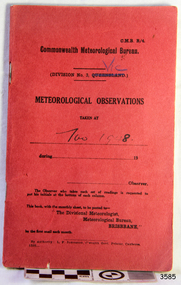
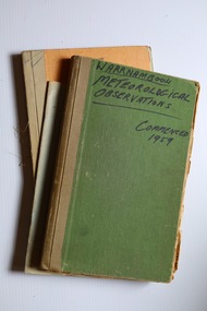
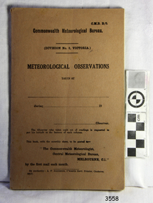
Book - Record Book, Commonwealth Meteorological Bureau, Meteorological Observations, November 1948
... Bureau...weather readings...weather patterns for the months and seasons, which then allows for warnings of events out of the normal or extreme, such as forecasting floods or droughts. Flagstaff Hill Flagstaff Hill Maritime Museum and Village Warrnambool Maritime Museum Maritime Village Great Ocean Road Shipwreck Coast Meteorological Observations Commonwealth Meteorological Bureau weather readings weather records weather history weather measurement weather record Division No 3 Queensland Victoria November 1848 Printed cover text includes "Central Meteorological Bureau" "METEOROLOGICAL OBSERVATIONS DIVISION No. 3 QUEENSLAND" Handwritten on cover "VIC" "Nov 1948." ...This book of Warrnambool's meteorological observations is dated November 1948. The book was published by the Commonwealth Meteorological Bureau, Victora Division. It was printed by L. F. Johnston, Commonwealth Government Printer, Canberra. It was originally printed for Division 3, Queensland but has been overwritten with 'Vic' [Victoria] and used for Warrnambool. Readings were recorded daily for barometric pressure, temperature, rain and wind velocity. At the end of each month, they were posted to the central Branch in Melbourne.These Meteorological Observations are an important accurate record of the local weather since the decades. They are part of Flagstaff Hill's Meteorological Observations collection of over seventy record books dating from the late 19th century. The collected information gives a picture of the weather patterns for the months and seasons, which then allows for warnings of events out of the normal or extreme, such as forecasting floods or droughts.Meteorological Observations record book. Recordings were taken at Warrnambool in November 1948. Small red cardboard printed cover with printed pages prepared for adding records. Published by the Commonwealth of Australia. The book was printed for Queensland; the cover has been altered by hand to read Vic [Victoria], but the fly page has not been altered.Printed cover text includes "Central Meteorological Bureau" "METEOROLOGICAL OBSERVATIONS DIVISION No. 3 QUEENSLAND" Handwritten on cover "VIC" "Nov 1948."flagstaff hill, flagstaff hill maritime museum and village, warrnambool, maritime museum, maritime village, great ocean road, shipwreck coast, meteorological observations, commonwealth meteorological bureau, weather readings, weather records, weather history, weather measurement, weather record, division no 3 queensland, victoria, november 1848 -
B-24 Liberator Memorial Restoration Australia Inc
Map - Silk Map of South West Pacific Ocean, Ocen Currents and Surface winds of the West pacific Area May-October
... OCEAN CURRENTS AND SURFACE WINDS FOR THE WEST PACIFIC AREA MAY- OCTOBER COMPILED BY THE 2ND AND 3RD OPERATIONS ANALYSIS SECTIONS,HQ, FEAF, FROM OCEAN CURRENT CHARTS DEIGNED BY THE SCRIPTS INSTITUTE OF OCEANOGRAPHY, AND FROM WIND CHARTS PREPARED BY THE U.S. WEATHER BUREAU. REPRODUCED BY R.A.A.F HEADQUARTERS [cartographic section] OCTOBER 1944 RESTRICTED...OCEAN CURRENTS AND SURFACE WINDS FOR THE WEST PACIFIC AREA MAY- OCTOBER COMPILED BY THE 2ND AND 3RD OPERATIONS ANALYSIS SECTIONS,HQ, FEAF, FROM OCEAN CURRENT CHARTS DEIGNED BY THE SCRIPTS INSTITUTE OF OCEANOGRAPHY, AND FROM WIND CHARTS PREPARED BY THE U.S. WEATHER BUREAU. REPRODUCED BY R.A.A.F HEADQUARTERS [cartographic section] OCTOBER 1944 RESTRICTED Square silk map Ocen Currents and Surface winds of the West pacific Area May-October Map Silk Map of South West Pacific Ocean. ...These maps were carried by air crew flying in the Pacific Ocean areas.Square silk mapOCEAN CURRENTS AND SURFACE WINDS FOR THE WEST PACIFIC AREA MAY- OCTOBER COMPILED BY THE 2ND AND 3RD OPERATIONS ANALYSIS SECTIONS,HQ, FEAF, FROM OCEAN CURRENT CHARTS DEIGNED BY THE SCRIPTS INSTITUTE OF OCEANOGRAPHY, AND FROM WIND CHARTS PREPARED BY THE U.S. WEATHER BUREAU. REPRODUCED BY R.A.A.F HEADQUARTERS [cartographic section] OCTOBER 1944 RESTRICTED -
 Whitehorse Historical Society Inc.
Document, Beryl Grey Eulogy Notes, 1/10/1997 12:00:00 AM
... Worked for Foodstuffs Contract Board, Central Contract Board, Weather Bureau....Worked for Foodstuffs Contract Board, Central Contract Board, Weather Bureau. Beryl Grey Eulogy Notes Document Document ...Photocopy of rough notes written by Bill Gray for the eulogy for Beryl GrayPhotocopy of rough notes written by Bill Gray for the eulogy for Beryl Gray to be given by her son, Andrew at the memorial service. Born in Shepparton 14/3/1924. Attended Surrey Hills Primary School and Benson St Methodist Church. Joined Government Departments until married in February 1956 to Bill Gray. Joined local organisations including Historical Society, C.A.A. and Elderly Peoples Housing Group. Worked for Foodstuffs Contract Board, Central Contract Board, Weather Bureau.Photocopy of rough notes written by Bill Gray for the eulogy for Beryl Gray gray, beryl -
 Department of Energy, Environment and Climate Action
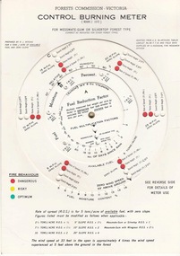
FCV Control burning meter, 1970
... By entering local rainfall records, the fuel load on the area to be burnt, wind speed at 33 feet above ground level and weather bureau estimates of temperature and relative humidity, the meter is used to indicate flame height, and the associated scorch height, that could be expected from lighting a grid of fires at regular intervals on level terrain - an allowance for slope variation was also possible....By entering local rainfall records, the fuel load on the area to be burnt, wind speed at 33 feet above ground level and weather bureau estimates of temperature and relative humidity, the meter is used to indicate flame height, and the associated scorch height, that could be expected from lighting a grid of fires at regular intervals on level terrain - an allowance for slope variation was also possible. ...The Forest Fire Danger Index (FFDI) was originally invented by the grandfather of Australian bushfire science, Alan Grant McArthur of the CSIRO, during the 1950s and ‘60s. Alan lit fires under various weather conditions and calculated their rates of spread under a range of fuel moisture conditions. He published his landmark paper, “Controlled burning in eucalypt forests” in 1962. Leaflet No. 80, as it was known, proved a turning point for forest and fire managers across Australia. More importantly, Alan was very practical forester and wanted his work to be useful to people in the field, so after several iterations he came up with the now familiar circular slide rule called the Forest Fire Danger Meter (FFDM). The Mk 4 version first appeared in operational use in 1967. Two Forests Commission staff, Athol Hodgson and Russ Ritchie, built on McArthur’s pioneering work and, by applying their own practical experience, developed a modified version in the late 1960s called the Control Burning Meter which was better suited to Victorian forest conditions. By entering local rainfall records, the fuel load on the area to be burnt, wind speed at 33 feet above ground level and weather bureau estimates of temperature and relative humidity, the meter is used to indicate flame height, and the associated scorch height, that could be expected from lighting a grid of fires at regular intervals on level terrain - an allowance for slope variation was also possible.Introduced to the FCV in 1970Control burning meterbushfire, forests commission victoria (fcv) -
 Warrnambool and District Historical Society Inc.
Administrative record (collection) - Warrnambool Meteorological Observations, Meteorological Observations, 1950s, 1960s, 1970s, 1980s
... Bureau of Meteorology, at that time in the Department of Science in the State of Victoria. Official Warrnambool meteorological observations are still recorded daily today. These items are of some importance as they form part of weather ...Official Recording of Warrnambool Meteorological ObservationsTwo bound ledgers and one paperback exercise book and a folder of correspondencewarrnambool weatherwarrnambool weather -
 Flagstaff Hill Maritime Museum and Village
Equipment - Stevenson Screen, Thomas Stevenson, ca. 1910
... weather records...meteorological forecast...meteorological record...Australian Bureau...Sometimes other meteorological instruments were included in the weather stations, so there were different Stevenson Screen sizes. This authentic, original Stevenson screen was previously owned by the Australian Bureau of Meteorology and was used for many years for weather readings at the Cape Otway Light Station in southwest Victoria. ...Stevenson screen, original, from the Australian Bureau of Meteorology’s weather station at the Cape Otway Lighthouse. ...Sometimes other meteorological instruments were included in the weather stations, so there were different Stevenson Screen sizes. This authentic, original Stevenson screen was previously owned by the Australian Bureau of Meteorology and was used for many years for weather readings at the Cape Otway Light Station in southwest Victoria. ...Stevenson screens were first introduced in Australia in the 1880s and were widely installed by 1910. The screens have been used to shelter and protect thermometers and other meteorological instruments from rain and direct heat while the holes and double-louvre walls allowed air to flow around them. Sometimes other meteorological instruments were included in the weather stations, so there were different Stevenson Screen sizes. This authentic, original Stevenson screen was previously owned by the Australian Bureau of Meteorology and was used for many years for weather readings at the Cape Otway Light Station in southwest Victoria. The Lighthouse Keepers recorded the readings for minimum and maximum temperatures at 9 a.m. every day from January 1865 until April 1994. The equipment was sheltered in a Stevenson Screen from 1902 until April 15 1994, when the mercury thermometer was replaced by a platinum resistance probe within an Automatic Weather Station (AWS). This Stevenson screen is one of the two screens that then became redundant. The other Stevenson screen was kept to display to visitors. Lightkeepers were no longer required at the Cape Otway Light station either, due to the automated system. The meteorological instruments donated with the screen were used for measuring temperature and humidity. They are mounted on a metal bracket that fits across the screw holes on the screen’s internal frame. The glass-covered Relative Humidity (RH) sensor was made by the renowned precision instrument maker, Rotronic AG of Switzerland, which was founded in 1965. The firm made its first electronic temperature and humidity instrument in 1967. Meteorological records have been collected in Australia from the 1800s. The records were collated, published and used as a basis for weather forecasts. Many sectors, such as maritime and agriculture industries, have relied on these figures for making important decisions. The quality and placement of the meteorological instruments used to measure temperature and humidity are of utmost importance for accuracy. In early colonial times, there were no national standards for meteorological instruments that would allow for accurate figures and comparisons. Once the Bureau of Meteorology was established (around 1908 to 1910) the department installed Stevenson screens throughout Australia, many at lighthouses and light stations, and the measuring instruments were standardised. The Stevenson Screen was named after its inventor, Scottish Civil Engineer Thomas Stevenson (1818-1887) who was also the father of Robert Louis Stevenson, author. Stevenson developed the small thermometer screen around 1867. It had double-louvred walls around the sides and a top of two asbestos sheets with an air space between them and was thickly painted with a white coating that reflected the sun’s rays. This design was modified in 1884 by Edward Mawley of the Royal Meteorological Society. Standards were set for the locations of the screens and instruments, including their distance above ground level and the direction the door faced.Stevenson screens played a significant part in providing a standardised shelter for all meteorological instruments used by the Australian Bureau of Meteorology from about 1910 until 1994. The readings from the instruments gave the meteorological statistics on which weather forecasts throughout Australia were based. This Stevenson screen was used locally at Cape Otway, along the Great Ocean Road in southwest Victoria, so contributed towards our local forecasts and weather warnings.Stevenson screen, original, from the Australian Bureau of Meteorology’s weather station at the Cape Otway Lighthouse. The screen is a white wooden cupboard with a slanted cover raised above the top. The top has ten drilled ventilation holes, and the sides and door are made of downward-slanting double louvres. Two brass hinges join the door to the lower edge of the screen and a metal fitting at the top edge allows for a padlock closure. The screen is supported on four short legs, each with a hole drilled from side to side for fitting to a frame. Inside the screen are two wooden frames fitted with hooks and screws. The floor has three boards; one across the back and one across the front at the same level, and a board wider than the space between these boards is fitted higher, overlapping them slightly. Inside the screen, a pair of electronic instruments with short electric cables is mounted on a metal bracket with drilled holes in it. One of the instruments is a Relative Humidity (RH) probe. It is 26 cm long and is a glass tube with a filter on one end and an electrical connection on the other. It has inscriptions on its label, showing that was made by Rotronic AG, Switzerland. The other instrument is a Resistance Temperature Device (RTD) thermometer. It is 22.5 cm long and has a narrow metal probe joined to a hexagonal metal fitting. A brass plate on the front of the screen has impressed inscriptions. The screen is Serial Number 01/C0032, Catalogue Number 235862.Stamped into brass plate "CAT. NO. / 253862 / SERIAL NO. 01/C0032" On instrument’s electrical fitting; “CD2” [within oval ‘+’ above S] “Serie693 op65 / 220/380V~16A” On instrument’s glass; “rotronic ag” “SWISS MADE” “CE / CH-8303 / Bassersdorf” Symbol for [BARCODE] “ART NO MP 101A_T4-W4W” “POWER 4.8.30VDC“ “OP. RANGE: 0-100%RH/-40+60° C” “OUT H 0-100% 0-1V” “OUT T -40+60°C -0.4..+0.6V” “SERIE NO 19522 009”flagstaff hill maritime museum and village, warrnambool, maritime museum, maritime village, great ocean road, shipwreck coast, cotton region shelter, instrument shelter, thermometer shelter, thermoscreen, thermometer screen, measuring instruments, meteorological instrument, weather recording, weather station, lighthouse equipment, light station equipment, stevenson screen, marine instruments, mercury thermometer, platinum resistance probe, aws, automatic weather station, rotronic ag, swiss made, meteorological device, weather forecast, weather prediction, weather records, meteorological forecast, meteorological record, australian bureau of meteorology, bureau of meteorology, bureau, bom, relative humidity, rh, relative humidity probe, resistance temperature device, rtd, thermometer, temperature, humidity, cape otway, cape otway lighthouse, cape otway light station, rotronic, switzerland, swiss instrument, thomas stevenson, double-louvered walls, edward mawley, royal meteorological society, 01/c0032, serial number, cat. no. 235862, serial no. 01/c00323 -
 Flagstaff Hill Maritime Museum and Village
Book - Record Book, Commonwealth Meteorological Bureau, Meteorological Observations, May 1945
... Bureau...Division No. 5 Victoria...weather...weather patterns for the months and seasons, which then allows for warnings of events out of the normal or extreme, such as forecasting floods or droughts. Flagstaff Hill Flagstaff Hill Maritime Museum and Village Warrnambool Maritime Museum Maritime Village Great Ocean Road Shipwreck Coast Meteorological Observations Commonwealth Meteorological Bureau Commonwealth Meteorologist Central Meteorological Bureau Division No. 5 Victoria weather readings weather records May 1945 weather history weather measurement weather record Printed text includes "Commonwealth Meteorological Bureau / DIVISION NO. 5 VICTORIA / METEOROLOGICAL OBSERVATIONS " and "The Observer who takes each set of readings is requested to put his initials at the bottom of each column" " Meteorological Observations, dated May 1945. ...This book of meteorological observations is dated May 1945. The book was published by the Commonwealth Meteorological Bureau, Victora Division. It was printed by L. F. Johnston, Commonwealth Government Printer, Canberra. Readings were recorded daily for barometric pressure, temperature, rain and wind velocity. At the end of each month, they were posted to the central Branch in Melbourne. These Meteorological Observations are an important accurate record of the local weather since the decades. They are part of Flagstaff Hill's Meteorological Observations collection of over seventy record books dating from the late 19th century. The collected information gives a picture of the weather patterns for the months and seasons, which then allows for warnings of events out of the normal or extreme, such as forecasting floods or droughts.Meteorological Observations, dated May 1945. Small brown cardboard printed cover with printed pages prepared for adding records. Published by the Commonwealth of Australia. Printed text includes "Commonwealth Meteorological Bureau / DIVISION NO. 5 VICTORIA / METEOROLOGICAL OBSERVATIONS " and "The Observer who takes each set of readings is requested to put his initials at the bottom of each column" "flagstaff hill, flagstaff hill maritime museum and village, warrnambool, maritime museum, maritime village, great ocean road, shipwreck coast, meteorological observations, commonwealth meteorological bureau, commonwealth meteorologist, central meteorological bureau, division no. 5 victoria, weather readings, weather records, may 1945, weather history, weather measurement, weather record -
 Flagstaff Hill Maritime Museum and Village
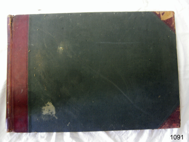
Book - Record Book, Warrnambool Lighthouse Register of Meteorological Observations 1916 Jul.jpg, 1910
... Warrnambool Shipwreck Coast Flagstaff Hill Flagstaff Hill Maritime Museum Flagstaff Hill Maritime Village Meteorological Observations 1910 Lighthouse Register weather records Lighthouse Keeper Handwritten records Warrnambool Lighthouse Register of Meteorological Observations 1916 July Hardcover book, green with red binding and reinforced corners. Pages have printed lines for rows and columns. Figures handwritten on each line Warrnambool Lighthouse Register of Meteorological Observations 1916 Jul.jpg Book Record Book Commonwealth Meteorological Bureau ...Book has been completed in 1916 by Warrnambool's Lighthouse KeeperThe weather records are a significant part of Warrnambool's history, helping to tell the story of local weather patterns on land and sea. The records can be used for understanding the events of wrecks and accidents at sea.Warrnambool Lighthouse Register of Meteorological Observations 1916 July Hardcover book, green with red binding and reinforced corners. Pages have printed lines for rows and columns. Figures handwritten on each lineHandwritten recordswarrnambool, shipwreck coast, flagstaff hill, flagstaff hill maritime museum, flagstaff hill maritime village, meteorological observations, 1910, lighthouse register, weather records, lighthouse keeper -
 Bayside Gallery - Bayside City Council Art & Heritage Collection
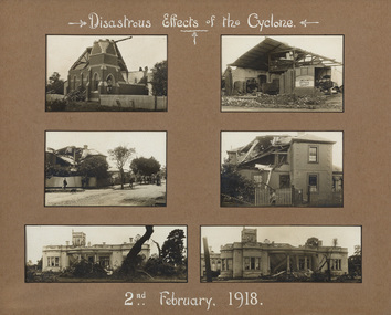
Photograph - sepia photograph, Disastrous effects of the cyclone, 1918
... Bureau of Meteorology. With wind speeds estimated at 320 km/h and resulting in the deaths of two people, the event caused tremendous destruction in Brighton. Cyclone Brighton Methodist Church Hawthorn Road Grant's Hay & Corn Store Wells Street Wellington Street Billilla Weatherly Halifax Street tornado Colonel Kendall Sepia photograph. ...On 2nd February 1918, Brighton experienced the most extreme cyclone to hit a major Australian city, as recorded by the Commonwealth Bureau of Meteorology. With wind speeds estimated at 320 km/h and resulting in the deaths of two people, the event caused tremendous destruction in Brighton.cyclone, brighton, methodist church, hawthorn road, grant's hay & corn store, wells street, wellington street, billilla, weatherly, halifax street, tornado, colonel kendall -
 Wodonga & District Historical Society Inc
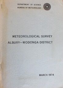
Book - Meteorological Study Albury Wodonga District March 1974, Australian Government Publishing Service
... Wodonga & District Historical Society Inc Hut 97, Bonegilla Migrant Experience, 132 Bonegilla Road Bonegilla the-murray Meteorology Wodonga Meteorology Albury Historical weather statistics climate Albury-Wodonga A compilation of historical records, tables, maps and data documenting meteorological observations throughout the Albury- Wodonga district. Records for Albury date from 1860 and those for Wodonga date from 1898. Other areas documented include Beechworth, Yackandandah and Corowa. Top right: Emblem of DEPARTMENT OF SCIENCE/ BUREAU ...A compilation of historical records, tables, maps and data documenting meteorological observations throughout the Albury- Wodonga district. Records for Albury date from 1860 and those for Wodonga date from 1898. Other areas documented include Beechworth, Yackandandah and Corowa.A plain covered publication. Pages are stapled stapled together down the left side of pages.A compilation of historical records, tables, maps and data documenting meteorological observations throughout the Albury- Wodonga district. Records for Albury date from 1860 and those for Wodonga date from 1898. Other areas documented include Beechworth, Yackandandah and Corowa.meteorology wodonga, meteorology albury, historical weather statistics, climate albury-wodonga -
 Parks Victoria - Gabo Island Lightstation
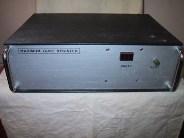
Wind Speed Recorder, "Maximum Gust Register"
... Like the other weather recording instruments in the collection, it became redundant to the Bureau of Meteorology’s needs. ...Like the other weather recording instruments in the collection, it became redundant to the Bureau of Meteorology’s needs. ...Used on Gabo Island to measure maximun gust over previous 3 hours or between weather observations. Information on the back of the device implies that it was battery powered and indicates that it was used in conjunction with a Synchrotac brand anemometer. Its particular function was to measure maximum wind speed over three hours between weather observations. Like the other weather recording instruments in the collection, it became redundant to the Bureau of Meteorology’s needs. It is a good example of its kind and has first level contributory significance for its historic value and provenance to the lightstation.Black metal box with grey metal front. Two chrome plated handles at front. Red plastic square, greenish coloured knob at front with inscriptions under them.On front,"MAXIMUM GUST REGISTER / KNOTS / READ" On back, "for use with a synchrotac anemometer / ANEMOMETER / RESET" On 2 black plastic discs at back, "BATTERY x 4 " -
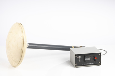
 Parks Victoria - Gabo Island Lightstation
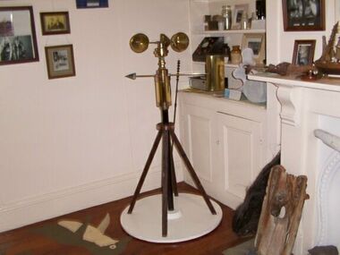
Anemometer
... Bureau of Meteorology donated it to the museum. It was then repaired and restored. The central pole on which it is mounted is galvanised iron pipe painted black. The anemometer, a portable device that manually measures wind speed, was a necessary instrument once common to all weather stations. ...Bureau of Meteorology donated it to the museum. It was then repaired and restored. The central pole on which it is mounted is galvanised iron pipe painted black. The anemometer, a portable device that manually measures wind speed, was a necessary instrument once common to all weather stations. ...This device was used to measure surface wind speed and direction. This anemometer was located on a concrete pad outside room 2.15 on a steel pole. The pole was considered unsafe and the anemometer was relocated to it's current position. When lowering the pole it fell over and was badly damaged. The Bureau of Meteorology donated it to the museum. It was then repaired and restored. The central pole on which it is mounted is galvanised iron pipe painted black. The anemometer, a portable device that manually measures wind speed, was a necessary instrument once common to all weather stations. The arms are attached to a vertical rod and as the wind blows, the cups rotate, making the rod spin. The stronger the wind blows, the faster the rod spins. The anemometer counts the number of rotations, or turns, which is used to calculate wind speed, surface wind and direction. They were designed to be durable to withstand the corrosive environment and strong winds expected at coastal sites such as those at Gabo Island. Anemometers existed in the nineteenth century and their design was improved by various experts including John Robinson in 1846, John Patterson in 1926, Brevoort and Joiner in 1935 and Derek Watson in 1991 who added wind direction measurement to its functions. This example was made for the Bureau of Meteorology by the Melbourne instrument company, Synchrotac, which became registered and incorporated on 26 July 1966. It is now displayed inside the building. A good example of its kind, the anemometer has first level contributory significance for its historic value and provenance to the lightstation.Anemometer and tripod stand. Three cupped brass discs on rotating arms fixed to turned brass cylinder shaped shaft. Beneath discs is a lead directional wind arrow attached to a rotating arm. A wooden three legged stand with central supporting pole of black painted hardwood and attached to a white painted marine ply circular base.Under wind cups: " SYNCHROTAC / MELB. / ser.no.70/372 / MADE IN AUSTRALIA." Above wind direction arrow: "C.OF.APT..../ SYNCHROTAC / MELB ? MADE IN AUSTRALIA / ser.no.70/372" -
 Parks Victoria - Wilsons Promontory Lightstation
Muslin & Wick
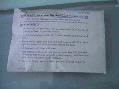
... It was acquired from the Bureau of Meteorology. Recording and communicating weather readings was an important facet of lightstation work and a number of different but related items of meteorological equipment survive at the six lightstations managed by parks Victoria. ...It was acquired from the Bureau of Meteorology. Recording and communicating weather readings was an important facet of lightstation work and a number of different but related items of meteorological equipment survive at the six lightstations managed by parks Victoria. ...This item, which dates to 1988, is contained in the original supply packet and survives in good condition. It was commonly used by lightkeepers for both wet and dry bulb thermometers, with the muslin going into the bottom of the dry bulb where it was held in place by the wick and ‘end of the wick was then placed in a jar of deep water to keep the bulb cool’. The difference in temperatures between the dry and wet bulb thermometers could then be worked out to establish the dew point in the air.They were common in lightstations, but this intact item remains in the original packaging and is a fine representative example of its kind. It was acquired from the Bureau of Meteorology. Recording and communicating weather readings was an important facet of lightstation work and a number of different but related items of meteorological equipment survive at the six lightstations managed by parks Victoria. The Cape Nelson collection includes a pair of Australian-made thermometers in their original box, both in Fahrenheit, with one recording the minimum, the other the maximum temperature and a barometer table with instructions for correcting readings. Cape Otway has a Beaufort Scale, a table of wind forces which lists 12 types on a scale of 1 to 12, and provides associated speed in knots and travel time per minute or hour. Gabo Island has an anemometer, wind speed indicator and a wind speed recorder.Muslin and wick for a wet bulb thermomenter in unopened white paper packaging with directions for use printed on the package on the front.On front of package,"MUSLIN AND WICK FOR WET BULB THERMOMETER......." -
Moorabbin Air Museum
Book - THE WEATHER WATCHERS, DAVID DAY, 2007
... Moorabbin Air Museum Moorabbin Airport 12 First Street Moorabbin melbourne THE WEATHER WATCHERS Book THE WEATHER WATCHERS DAVID DAY BUREAU OF METEOROLOGY ... -
 Department of Energy, Environment and Climate Action
Lightning Detector
... Bureau of Meteorology's (BOM) current lightning detector network uses radio waves emitted by lightning to pinpoint the location of lightning strikes. The network is operated by a private company that sends data to the BOM in real time. Lightning detection systems use sensors like antennas, GPS receivers, and processing systems to detect radio waves, also known as sferics. The systems calculate the lightning's location and speed by measuring how long it takes for the radio signal to reach the different antenna stations. The BOM also has a Thunderstorm Tracker that uses weather...Bureau of Meteorology's (BOM) current lightning detector network uses radio waves emitted by lightning to pinpoint the location of lightning strikes. The network is operated by a private company that sends data to the BOM in real time. Lightning detection systems use sensors like antennas, GPS receivers, and processing systems to detect radio waves, also known as sferics. The systems calculate the lightning's location and speed by measuring how long it takes for the radio signal to reach the different antenna stations. The BOM also has a Thunderstorm Tracker that uses weather ...Lightning is one of the major causes of bushfires, particularly in the remote mountains. This lightning detector system was developed by Dr. Peter Kourtz at Canada’s forest fire research institute. By 1977, some 300 were in use across the country. The small mushroom antenna could detect short-range (20-mile) changes in electrostatic field associated with lightning strikes. It needed to be placed out in the open on a hilltop and away from nearby trees. It simply counted the number of "strikes". The detector doesn't seem to have a direction finding capability or be able to distinguish between cloud-to-cloud or cloud-to-ground lightning. It's not sure how this particular unit found its way to Victoria. The Bureau of Meteorology's (BOM) current lightning detector network uses radio waves emitted by lightning to pinpoint the location of lightning strikes. The network is operated by a private company that sends data to the BOM in real time. Lightning detection systems use sensors like antennas, GPS receivers, and processing systems to detect radio waves, also known as sferics. The systems calculate the lightning's location and speed by measuring how long it takes for the radio signal to reach the different antenna stations. The BOM also has a Thunderstorm Tracker that uses weather radar data to identify areas of potential thunderstorm activity. The tracker updates every six minutes and shows the direction thunderstorms are moving, as well as their expected position in 10, 20, and 30 minutesLightning detector 1970sQ-Techforests commission victoria (fcv), weather, bushfire, bushfire aviation