Showing 193 items matching "weatherboard hill"
-
 Ballarat Heritage Services
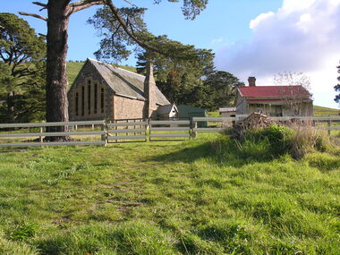
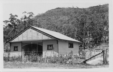
Photograph - Photograph - Colour, Clare Gervasoni, Former School at Weatherboard, Victoria, c2010
... ...Weatherboard Hill Common School...The School, Number 656, was opened on 01 August 1862 and closed on 04 February 1948. it was also known as Weatherboard Hill Common School and Weatherboard Hill State School.The bluestone school building had a slate roofand its first head teacher was James Richmond..In 1915 Health Officer, Dr Willis, strongly condemned the old bluestone building as being damp and unsanitary. in 1948 enrolments dropped to 6 and the school closed. ...Weatherboard School Former Weatherboard School Education Weatherboard Hill Common School Weatherboard Hill State School An early bluestone school known as the Weatherboard School. ...Weatherboard is a small town in Western Victoria.Anecdotally the name is thought to have originated because it was the first place in the region to have a home built using weatherboard rather than corrugated iron, stone or bricks. It is in the boundaries of the City of Ballarat. The School, Number 656, was opened on 01 August 1862 and closed on 04 February 1948. it was also known as Weatherboard Hill Common School and Weatherboard Hill State School.The bluestone school building had a slate roofand its first head teacher was James Richmond..In 1915 Health Officer, Dr Willis, strongly condemned the old bluestone building as being damp and unsanitary. in 1948 enrolments dropped to 6 and the school closed. The Weatherboard State School World War One Honour Board is located at Burrumbeet Hall. An early bluestone school known as the Weatherboard School.weatherboard school, former weatherboard school, education, weatherboard hill common school, weatherboard hill state school -
 Learmonth and District Historical Society Inc.
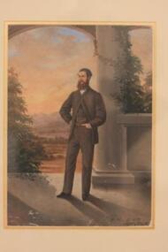
Photo - Richmond, Unknown, James Richmond
... ...weatherboard hill state school...James Richmond was born at Hamilton ,Lanarkshire in Scotland on 24th November 1840.He migrated to Australia at age 21, on the sailing vessel "City of Melbourne", arriving 23rd July,1862.He made his way to the Ballarat district and secured a position as head teacher at Weatherboard Hill State School. On 25th April 1866 he was selected as the first full time Shire Secretary, at a starting salary of 250 pounds per annum, (the previous position having only been part time). ...First fulltime Shire Secretary of the Ballarat shire,1866-1879. richmond james 1840 1879 shire secretary 1866 weatherboard hill state school richmond park learmonth JAMES RICHMOND age 28 1868. ...James Richmond was born at Hamilton ,Lanarkshire in Scotland on 24th November 1840.He migrated to Australia at age 21, on the sailing vessel "City of Melbourne", arriving 23rd July,1862.He made his way to the Ballarat district and secured a position as head teacher at Weatherboard Hill State School. On 25th April 1866 he was selected as the first full time Shire Secretary, at a starting salary of 250 pounds per annum, (the previous position having only been part time). On February 26th 1867 James married Annie Dobson and they had four sons and two daughters. Their residence was a dwelling attached to the original Shire Offices at Learmonth.During his term he took on various other roles. In July 1873 "Richmond Park" on the foreshore of Lake Learmonth was named in his honour.James Richmond died on 29th December,1879 (while still in office),from a severe attack of rheumatic fever at age 39, leaving Annie to raise their six children.First fulltime Shire Secretary of the Ballarat shire,1866-1879. Coloured painting of James Richmond set in narrow brown frame with cream mount and narrow "gold" edge around painting.in bottom right corner is marked "James Richmond age 28 1868" and on the right "W.H. R.A.S. May 1868.JAMES RICHMOND age 28 1868. W.H. R.A.S. May 1868richmond james 1840 1879, shire secretary 1866, weatherboard hill state school, richmond park learmonth -
 Federation University Historical Collection
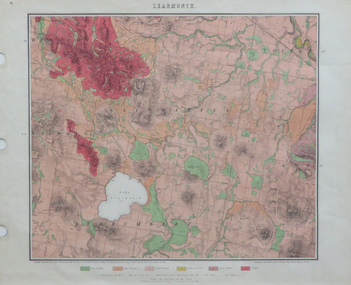
Map, Geological Map of Learmonth, 1882, 10/1882
... ...weatherboard hill...Barker Library (top floor) Mount Helen goldfields learmonth lake learmonth glendaruel burrumbeet mt blowhard morton's hill mt bolan addington mt cavern coghill's hill mt hollowback mt pisgah weatherboard hill webster's hill foster's hill mt bolen one mile hill vaughan's hill tourello stattion ballarat to maryborough railway saddleback hill ceres brown's hill ross's hill norman taylor robert burrows richard shephard james finnie Two copies: (printed noted attached) 3.) ...Two copies: (printed noted attached) 3.) Rectangular geological map edged in masking tape. Six colours define geology and are predominantly pink. Scale 40 chains to one inch .4) Notes referring to the Geological Map of Learmonth learmonth, lake learmonth, glendaruel, burrumbeet, mt blowhard, morton's hill, mt bolan, addington, mt cavern, coghill's hill, mt hollowback, mt pisgah, weatherboard hill, webster's hill, foster's hill, mt bolen, one mile hill, vaughan's hill, tourello stattion, ballarat to maryborough railway, saddleback hill, ceres, brown's hill, ross's hill, norman taylor, robert burrows, richard shephard, james finnie -
 Whitehorse Historical Society Inc.
Article, Splashing Out In Colour, 2001
... Hill...Weatherboard...Reed Family Forest Hill Weatherboard Forest Hill Chase Article with photo of the Reed Family Article with photo of the Reed Family and article on the renovation of their 1950's Forest Hill house. ...Article with photo of the Reed FamilyArticle with photo of the Reed Family and article on the renovation of their 1950's Forest Hill house.Article with photo of the Reed Family reed family, forest hill, weatherboard, forest hill chase -
 Federation University Historical Collection
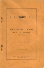
Booklet, Thomas Stephen Hart, The Highlands and Main Divide of Western Victoria, 1907, 12/12/1907
... hill...mt blowhard...weatherboard...Hart was a teacher at the Ballarat School of Mines, and a member of the Ballarat Field Naturalists Club thomas hart thomas s. hart ballarat school of mines ballarat field naturalists club royal society of victoria western victoria ballarat great dividing range mt william volcano volcanic plains waterways lal lal basin yarrowee creek ballarat common lava flow wendouree warrenheip ballarat plateau mt elephant grampians t.s. hart mt buangor mt beckworth mt misery mt bolton lal lal iron ored mt ararat mt wiliam mt cole burrumbeet mt warrenheip daylesford waubra ercildoun gap smythesdale lal lal falls parwan valley burrumbeet creek staffordshire reef pyranees bacchus marsh rowsley fault ben nevis avoca hill landsborough hill mt blowhard weatherboard mclean's hill Fyan's Creek thomas stephen hart lal lal Article with illustrations published by the Royal Society of Victoria by Thomas S. ...Thomas S. Hart was a teacher at the Ballarat School of Mines, and a member of the Ballarat Field Naturalists ClubArticle with illustrations published by the Royal Society of Victoria by Thomas S. Hart. The following plates are included: Fig 1. The Main Divide and some of the transverse ridges Fig 2. Hills on and near the Divide at the Ercildoun and Ascot Gaps Fig. 3. Profile of the Divide at Ascot Gap. Fig. 4. Sketch of the Hills west and north-west from Mt Buninyong - - The divide in Ascot Gap from Mt Blowhard (Serra Range, Mt William, Mt Ararat, Larne Gerin, Ben Major, Mt Cole, Mt Misery, Mt Bolton) Fig. 5. Diagram to illustrate the possible courses of the leads south of the present Divide - Burrumbeet Basin (Smythesdale, Ballarat, Lal Lal , Mt Doran, egerton, Parwan Creet, Rowsley Fault, Eastern Plateau) Fig. 6. Diagramatic cross section of the grampians, south of Hall's Gap. Profile of the Pyranees, from maiden Hill - Diagramatic Section of the Grampians south of Hall's Gap. (Mt Cole, Mt Mitchell, Ben Major, Ben More, Avoca Hill, Hall's Gap.) Fig. 7. Profile of the Pyrenees as seen from Maiden Hill near Waubra.thomas hart, thomas s. hart, ballarat school of mines, ballarat field naturalists club, royal society of victoria, western victoria, ballarat, great dividing range, mt william, volcano, volcanic plains, waterways, lal lal basin, yarrowee creek, ballarat common, lava flow, wendouree, warrenheip, ballarat plateau, mt elephant, grampians, t.s. hart, mt buangor, mt beckworth, mt misery, mt bolton, lal lal iron ored, mt ararat, mt wiliam, mt cole, burrumbeet, mt warrenheip, daylesford, waubra, ercildoun gap, smythesdale, lal lal falls, parwan valley, burrumbeet creek, staffordshire reef, pyranees, bacchus marsh, rowsley fault, ben nevis, avoca hill, landsborough hill, mt blowhard, weatherboard, mclean's hill, fyan's creek, thomas stephen hart, lal lal -
 Ballarat Heritage Services
Pamphlet - Photograph - Black and White, Yandoit Hill State School (No 2052)
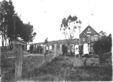
... A number of students in front of a weatherboard school at Yandoit Hill. ...After the closure of the school the building was moved to the corner of Main Road and Seventh Street, Hepburn Springs. yandoit yandoit hill state school yandoit hills yandoit creek education A number of students in front of a weatherboard school at Yandoit Hill. ...The land for this school was donated by Carlo Gervasoni. After the closure of the school the building was moved to the corner of Main Road and Seventh Street, Hepburn Springs.A number of students in front of a weatherboard school at Yandoit Hill. yandoit, yandoit hill state school, yandoit hills, yandoit creek, education -
 Bendigo Historical Society Inc.
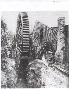
Photograph - Phillip's Water Wheel, Diamond Hill, Bendigo, Unknown
... Image shows the Phillip's Water Wheel on Diamond Hill, Bendigo. Weatherboard building on right hand side of image, brick chimney on side of building. ...Image shows the Phillip's Water Wheel on Diamond Hill, Bendigo. Weatherboard building on right hand side of image, brick chimney on side of building. ...The site of the water wheel is still visible on the side of the water race at Diamond Hill, Bendigo. Messrs. George Phillips and Richard Williams erected a water wheel crushing machine near the site of the Old Albert shaft at Diamond Hill'. ( Bendigo Advertiser 4th June, 1890). The lack of water available for the venture from the water race caused much controversy in the following years. There was only enough water available in July 1890, to allow the company to operate three head of a ten head stamper. Mr. Geo Phillips held 1000 shares in the float of the Kangaroo Hydraulic Crushing & Gold Mining Company. He was one of the largest shareholders. (Victorian Government Gazette 72 Page 2260, 1893) Black and white photocopy of original. Image shows the Phillip's Water Wheel on Diamond Hill, Bendigo. Weatherboard building on right hand side of image, brick chimney on side of building. Large water wheel in cutting directly alongside building. Two men standing in between water wheel and building, one man standing on landing of waterwheel.mining, sandhurst, phillip's hydraulic waterwheel, stafford gold mine, diamond hill, george phillips, richard williams -
 Bendigo Historical Society Inc.
Article - Michele Matthews Collection: PHD Research - Taylor Family Transcript of Audio Interview, 1930s
... Hill near Chum Street. Although he initially pursued gold, he later secured work as a pattern maker in one of Bendigo's foundries before becoming a house builder as mining declined. He married Susanna Johnson, and together they raised nine children, establishing a family whose descendants remained closely connected with Bendigo for generations. The narrative then focuses on Henry Johnson Taylor, the youngest son, and his wife Elva May Hartin, whose son Howard Johnson Taylor was born on 9 September 1912 in a weatherboard...Hill near Chum Street. Although he initially pursued gold, he later secured work as a pattern maker in one of Bendigo's foundries before becoming a house builder as mining declined. He married Susanna Johnson, and together they raised nine children, establishing a family whose descendants remained closely connected with Bendigo for generations. The narrative then focuses on Henry Johnson Taylor, the youngest son, and his wife Elva May Hartin, whose son Howard Johnson Taylor was born on 9 September 1912 in a weatherboard ...Dr Michele Matthews has been a local and social historian for nearly three decades since she first used correspondence held by the then Bendigo City Council for her Honours thesis. She is an ardent advocate for the use of local history records to tell Victorian and Australian history from a grassroots perspective. Michele’s MA thesis, ‘A forgotten “Father” of Federation: Sir John Quick 1852‑1911’ (2003), and her PhD thesis, ‘Survivors, schemes, Samaritans and shareholders: the impact of the Great Depression on Bendigo and District 1925‑1935’ (2007), both drew heavily on Bendigo and district records. Michele Matthews Collection: PHD Research - Taylor Family Transcript of Audio Tape Interview This item includes the following document: 8672.91a Black and White photo of the Taylor house in Panton Street - Scanned from the transcript - Only a representation of the original photo. 8672.91b The document presents the early history of the Taylor family of Bendigo, tracing several generations from the arrival of John William Taylor in Victoria during the gold rush through to the childhood and early adulthood of Howard Johnson Taylor. Drawing heavily on oral history interviews, it describes how the family's experiences reflected the broader social and economic development of Bendigo, from the goldfields to the Depression era. Historical photographs of family members, homes and possessions accompany the narrative. The story begins around 1860, when John William Taylor emigrated from England and walked from Melbourne to Bendigo carrying his belongings. Attracted by the gold rush, he acquired a miner's right and built a timber home on Specimen Hill near Chum Street. Although he initially pursued gold, he later secured work as a pattern maker in one of Bendigo's foundries before becoming a house builder as mining declined. He married Susanna Johnson, and together they raised nine children, establishing a family whose descendants remained closely connected with Bendigo for generations. The narrative then focuses on Henry Johnson Taylor, the youngest son, and his wife Elva May Hartin, whose son Howard Johnson Taylor was born on 9 September 1912 in a weatherboard house on Specimen Hill. Howard's early childhood was marked by tragedy when his mother died in childbirth while expecting another child. The account reflects on the limitations of rural medical care at the time, suggesting that faster transport may have saved her life. Following her death, the family moved to Golden Square, and Henry later remarried May Whitcombe, who became Howard's stepmother. Howard's childhood provides an insight into everyday life in early twentieth-century Bendigo. The family experienced the influenza epidemic that followed the First World War, although Henry survived despite lasting health effects. Howard recalled living in several homes built or renovated by his father, including properties in Panton Street and later Echuca Street, Quarry Hill. The document describes domestic life in detail, including wood-fired bath heaters, heating and cooking with timber, and the pride taken in maintaining weatherboard houses. Education forms another important theme. Howard attended Specimen Hill State School, Golden Square State School, Quarry Hill State School, and later Bendigo High School. He remembered strict discipline, small class sizes in the primary years, and a strong interest in mathematics, particularly algebra and geometry. Despite enjoying school and performing well academically, the economic pressures of the Great Depression forced him to leave after obtaining his Merit Certificate so he could work alongside his father in the building trade. He later attended night classes to improve his building and bookkeeping skills. The memoir also captures changing technology and transport during Howard's youth. The family initially travelled by horse and buggy before purchasing a Chevrolet touring car in 1925, a significant financial investment at the time. Howard developed a lifelong enthusiasm for motor vehicles, learning to drive as a teenager and eventually owning numerous cars. He also briefly owned a B.S.A. motorcycle before replacing it with a Ford V8 Roadster, illustrating the rapid shift from horse-drawn transport to motor vehicles during the interwar years. Throughout the document, Howard's recollections provide valuable insight into family life, housing, education, employment, transport and community in Bendigo between the 1860s and the 1930s. Rather than simply recording genealogical facts, the narrative places the Taylor family's experiences within the broader history of Bendigo's growth from a gold mining settlement into a well-established regional city. The final pages consist of detailed footnotes referencing the original oral history recordings from which many of the quotations were drawn.bendigo, michele matthews collection, taylor transcript of audio tape interview -
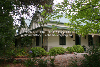
 Eltham District Historical Society Inc
Photograph - Digital Photograph, Alan King, Panton Hill Primary School, 27 March 2008
... The former teacher’s residence is the only surviving 19th century dwelling in the centre of Panton Hill, and is now used as part of the school. The residence was originally rectangular but is now L-shaped. Similar weatherboard...The former teacher’s residence is the only surviving 19th century dwelling in the centre of Panton Hill, and is now used as part of the school. The residence was originally rectangular but is now L-shaped. Similar weatherboard ...The Panton Hill Primary School building, which has served the community since 1889, was not the area's first. Kingston School (an early name for Panton Hill) opened in May 1865. This was replaced in 1871 when the Panton Hill School number 1134 opened and in 1874 the school moved to its current location [September 2023] where many additions and renovations have taken place to meet the needs of local children in the 21st century. Covered under Heritage Overlay, Nillumbik Planning Scheme. Published: Nillumbik Now and Then / Marguerite Marshall 2008; photographs Alan King with Marguerite Marshall.; p63 The Panton Hill Primary School building, which has served the community since 1889, was not the area’s first. In 1871 Henry Edelman opened a Common School in a paling-clad hut, replacing the Kingstown No 786 school. The two-acre (0.8ha) site of crown land had previously been held under Miners Right. In 1875 the Education Department bought a building on the main road for State School No 1134, for £200 and remodelled it as a school.4 Panton Hill had as one of its teachers, Frank Tate, who was to become one of Victoria’s most influential educational reformers. It was his first school, when he began teaching on January 22, 1884, as a 20 year old.5 The following month Robert J Harris was appointed to the school and remained as head teacher until his death in 1887. His son R C Harris was apprenticed to Mr Rossiter, editor of the first local paper. The Evelyn Observer, first published in 1873. Harris later bought the newspaper which remained a family business until the 1920s. J Hughes of Cherry Tree Road succeeded Harris as teacher at Panton Hill and sold his land for the school site. Though now unrecognisable, the school building includes the classroom of the last Smiths Gully State School No 1737, which was built in 1882, and moved to Panton Hill in 1894. From 1922 each school day began with the ringing of the bell, which is still in its stand, and is an unusually old memorial of this kind. To accommodate the growing population, the building was remodelled, with additions in 1923 and classrooms were added in 1955, 1963 and 1970. The former teacher’s residence is the only surviving 19th century dwelling in the centre of Panton Hill, and is now used as part of the school. The residence was originally rectangular but is now L-shaped. Similar weatherboard State School buildings in the shire from this period are the Kangaroo Ground and the St Andrews Primary Schools. All were standard Education Department/Public Works Department designs.This collection of almost 130 photos about places and people within the Shire of Nillumbik, an urban and rural municipality in Melbourne's north, contributes to an understanding of the history of the Shire. Published in 2008 immediately prior to the Black Saturday bushfires of February 7, 2009, it documents sites that were impacted, and in some cases destroyed by the fires. It includes photographs taken especially for the publication, creating a unique time capsule representing the Shire in the early 21st century. It remains the most recent comprehenesive publication devoted to the Shire's history connecting local residents to the past. nillumbik now and then (marshall-king) collection, panton hill primary school -
 Eltham District Historical Society Inc
Photograph - Digital Photograph, Alan King, Pigeon Bank, Kangaroo Ground-Warrandyte Road, Kangaroo Ground, 6 February 2008
... Although close to the road, the white weatherboard Victorian farmhouse is ensured privacy by the trees and hedges around it. On 4.8 hectares of farmland, Pigeon Bank is surrounded by rolling hills, farmland and bush, the peace of which is punctuated by an occasional birdcall. ...Although close to the road, the white weatherboard Victorian farmhouse is ensured privacy by the trees and hedges around it. On 4.8 hectares of farmland, Pigeon Bank is surrounded by rolling hills, farmland and bush, the peace of which is punctuated by an occasional birdcall. ...In 1848, Francis Rogerson form Dumfriesshire, Scotland purchased 80 acres of land at Kangaroo Ground on which he built a two-roomed bark hut. He named the property afterr the many Bronzewings and Wonga Pigeons in the area. Ewen Hugh Cameron moved to Pigeon Bank the same year he was elected to Parliament as the Member for Evelyn. At the time he moved in, Pigeon Bank had six rooms and the present water well. He made further extensive additions and lived there until his death in 1915. Covered under Heritage Overlay, Nillumbik Planning Scheme. Published: Nillumbik Now and Then / Marguerite Marshall 2008; photographs Alan King with Marguerite Marshall.; p27 Pigeon Bank, on the Kangaroo Ground – Warrandyte Road, Kangaroo Ground, is one of the Shire’s oldest farm dwellings, and has been home to some of the district’s earliest and most distinguished families. Although close to the road, the white weatherboard Victorian farmhouse is ensured privacy by the trees and hedges around it. On 4.8 hectares of farmland, Pigeon Bank is surrounded by rolling hills, farmland and bush, the peace of which is punctuated by an occasional birdcall. Pigeon Bank’s first owner was Francis Rogerson, from Dumfriesshire, Scotland, who bought 80 acres (32.4ha) of land in 1848 on which he built a two-roomed bark hut. Today this is the centre piece of the 14-room home.1 Rogerson lined the rooms with tongue-and-groove boards and roofed them with wooden shingles and sapling frames, which remain under the present green corrugated iron roof. He named Pigeon Bank after the many forest bronzewing and Wonga Pigeons in the area at the time, and the name Bank was commonly used in Scotland. Rogerson was united with one of the oldest families in the area when his sister Janet married John Bell, son of William, the original Bell settler. When Ewen Cameron moved to Pigeon Bank in 1874 it had six rooms and the present water well. He made extensive additions to the house and farm buildings and lived at Pigeon Bank until his death in 1915. Cameron, who had arrived in Melbourne from Scotland in 1853, contributed an enormous amount to the community. He worked as a builder, as a miner at Andersons Creek, a storekeeper at Queenstown2 and as the first postmaster at Warrandyte. In 1867 he married Agnes Bell, daughter of local farmer, John Bell. Cameron was a member of the Eltham Road Board (which preceded the Shire Council) and for more than 50 years, from 1863, he was an Eltham Shire Councillor, being President three times. Cameron was the Member for Evelyn for 40 years from 1874. In the 1880s he became the Government Whip, in 1902 the Minister for Mines and Water Supply, and in 1904, the Minister for Health, Cameron was also an outstanding farmer, whose farm won the Agricultural Department prize for the finest in the district, three consecutive times. Not surprisingly Pigeon Bank became the centre of district life. Every New Year’s Eve, Cameron hired a highland piper, who marched from the Kangaroo Ground school house to Pigeon Bank playing his pipes.3 Distinguished visitors included opera singer, Dame Nellie Melba, Victorian Premier, Thomas Bent, Governor, Lord Hopetoun and artist, Longstaff. Following Cameron’s death, the property changed hands several times, then returned to the family in 1919 when bought by Gordon Cameron. As the car took over from the horse, Pigeon Bank entered difficult times because the farm had produced chaff and oats and bred Clydesdales and harness ponies. In 1926 Mr Matthews bought the property and made many alterations including pulling down the kitchen, which had been separate from the main house. The property again changed hands several times. One owner was Senator James F Guthrie, who added a sunroom. In 1968 the house again returned to the Cameron family, when Vera Jackson, a grand-daughter of Ewen Cameron, and her husband, bought the property. The Bishop family, who were sixth and seventh generation Bells and also descended from the Camerons, restored the house in the 1980s. Today tongue-and-groove boards still line part of the hall (which retains two fine arches), the breakfast room, and Ewen Cameron’s former room. Five original fireplaces in the bed and living rooms are still in working order. The wide veranda with a curved iron roof and ornate iron lace work bounds three sides of the house, and nearby a windmill stands beside the water well. Sue and Ron James, who bought the property in 2001, made extensive improvements to the homestead and meticulously restored the grounds to their original state.This collection of almost 130 photos about places and people within the Shire of Nillumbik, an urban and rural municipality in Melbourne's north, contributes to an understanding of the history of the Shire. Published in 2008 immediately prior to the Black Saturday bushfires of February 7, 2009, it documents sites that were impacted, and in some cases destroyed by the fires. It includes photographs taken especially for the publication, creating a unique time capsule representing the Shire in the early 21st century. It remains the most recent comprehenesive publication devoted to the Shire's history connecting local residents to the past. nillumbik now and then (marshall-king) collection, ewen hugh cameron, francis rogerson, kangaroo ground, kangaroo ground-warrandyte road, pigeon bank -
 Bendigo Historical Society Inc.
Photograph - THE EYRIE, QUARRY HILL
... Colour photograph: 'The Eyrie' in Reginald Street, Quarry Hill being painted in March 1986. The front of an old weatherboard house painted cream, grey, tan and brown. ...History House 11 Mackenzie Street Bendigo goldfields BUILDINGS Residential the eyrie Colour photograph: 'The Eyrie' in Reginald Street, Quarry Hill being painted in March 1986. The front of an old weatherboard house painted cream, grey, tan and brown. ...Colour photograph: 'The Eyrie' in Reginald Street, Quarry Hill being painted in March 1986. The front of an old weatherboard house painted cream, grey, tan and brown. John Quick and Barkley Hyett consulted about the wording of the Australian Constitution in this home. Physical description: Unmounted photograph. Inscriptions/Markings: The Eyrie, March 86, Painting.buildings, residential, the eyrie -
 Bendigo Historical Society Inc.
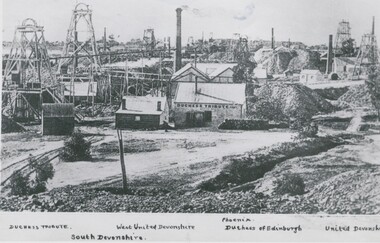
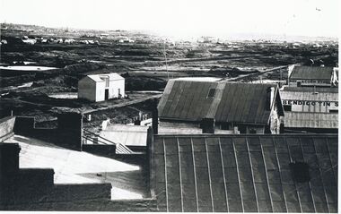
Photograph - DEVONSHIRE GROUP OF MINES, C 1896
... weatherboard building at centre. Handprinted above image ( on earlier copy of this image of which this is a photograph ) ' Devonshire Group of Mines/Snob's Hill and Mungo Mines in Background. ...weatherboard building at centre. Handprinted above image ( on earlier copy of this image of which this is a photograph ) ' Devonshire Group of Mines/Snob's Hill and Mungo Mines in Background. ...black and white photograph 3 copies : view across mining area showing at least 9 poppet heads, at least 11 chimneys and many buildings associated with the mines. Centre to left - flume, wood stacks, mullock heaps. In image ' Duchess Tribute' on weatherboard building at centre. Handprinted above image ( on earlier copy of this image of which this is a photograph ) ' Devonshire Group of Mines/Snob's Hill and Mungo Mines in Background. Printed below image ' Ducches Tribute' ' South Devonshire' ' West United Devonshire ' ' Phoenix' ' Duchess of Edinburgh' ' United Devonshire 'organization, business, devonshire group of mines -
 Bendigo Historical Society Inc.
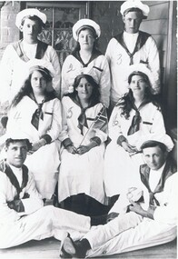
Photograph - FANCY DRESS BALL: WHITE HILLS
... Black and white photograph : opening fancy dress ball, White Hills Reading Room. 8 young adults in sailor suits, 4 female, 4 male. Brick wall, windows and weatherboard wall at back. ...History House 11 Mackenzie Street Bendigo goldfields COTTAGE Miners Black and white photograph : opening fancy dress ball, White Hills Reading Room. 8 young adults in sailor suits, 4 female, 4 male. Brick wall, windows and weatherboard wall at back. ...Black and white photograph : opening fancy dress ball, White Hills Reading Room. 8 young adults in sailor suits, 4 female, 4 male. Brick wall, windows and weatherboard wall at back. Female in centre hoilding small Union Jack flag. Figures have been numbered. Note hole in sole of shoe on right. On front pencil numbers 1 - 8 - one on each person. Names on back of photo correspond to numbers. 1. Arthur Caldwell 2. Mary Dixon ( Mrs. E.M. Bourke ) 3 Frank Dixon 4 Joy Bovard ( Ball ) 5 Imelde Flack 6 Lizzie Richards ( Gay Wood ? ) 7 Ernie Cawden 8. George Cailcottage, miners -
 Bendigo Historical Society Inc.
Photograph - BENDIGO LANDSCAPE: LOOKING SOUTHWEST 1856, C 1856 ?
... weatherboard with corrugated iron or zinc rooves. Left centre appears to be stable with loft doors. Middle distance - many buildings with heaps of dirt/rock. Far distance - many small buildings ( houses ) chimneys, trees hills...weatherboard with corrugated iron or zinc rooves. Left centre appears to be stable with loft doors. Middle distance - many buildings with heaps of dirt/rock. Far distance - many small buildings ( houses ) chimneys, trees hills ...Black and white photograph of mines at Bendigo. 'Bendigo Tin' on side of building, 'Hay and corn store' at rear. Poppet heads and dams visible. In foreground - larger buildings, mostly weatherboard with corrugated iron or zinc rooves. Left centre appears to be stable with loft doors. Middle distance - many buildings with heaps of dirt/rock. Far distance - many small buildings ( houses ) chimneys, trees hills. James Lerk 11.2.2000 ' C 1856 looking southwest , Forest St. ( tin smith ) going to the right.place, landscape view, bendigo mining -
 Bendigo Historical Society Inc.
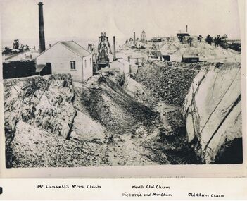
Photograph - LANSELL'S 180 CLAIM, approx. 1875
... Weatherboard building at left with wood pile and brick chimney. 3 poppet heads in middle distance. 1 poppet head on horizon. Total of 4 chimneys visible. Im inage on original photo ' …. Reef near Ironbark Hill...Weatherboard building at left with wood pile and brick chimney. 3 poppet heads in middle distance. 1 poppet head on horizon. Total of 4 chimneys visible. Im inage on original photo ' …. Reef near Ironbark Hill ...Black and white photograph of original. Large excavation in foreground. Weatherboard building at left with wood pile and brick chimney. 3 poppet heads in middle distance. 1 poppet head on horizon. Total of 4 chimneys visible. Im inage on original photo ' …. Reef near Ironbark Hill' In margin at bottom ' Mr. Lansell's No. 180 claim/North Old Chum/Victoria and New Chum/Old Chum Claim'Original photo by N.J. Caire, 1875, looking south New Chum or Victoria Reef'organization, business, lansell's 180 claim -
 Bendigo Historical Society Inc.
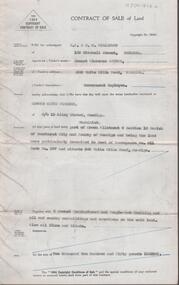
Document - H. A. & S. R. WILKINSON COLLECTION: CONTRACT OF SALE
... Property: land being part of Crown allotment 8 section 19 Parish of Sandhurst, City of Bendigo being land described in deed of conveyance No. 11 book No. 567 and situate 306 White Hills Road, Bendigo, together with 5 roomed weatherboard and rough cast dwelling and all sundry buildings on said land. ...Property: land being part of Crown allotment 8 section 19 Parish of Sandhurst, City of Bendigo being land described in deed of conveyance No. 11 book No. 567 and situate 306 White Hills Road, Bendigo, together with 5 roomed weatherboard and rough cast dwelling and all sundry buildings on said land. ...Contract of sale of land dated 25th February, 1955 between Mr. E. C. Spence (vendor) and Mr. E. K. Pipkorn (purchaser). Property: land being part of Crown allotment 8 section 19 Parish of Sandhurst, City of Bendigo being land described in deed of conveyance No. 11 book No. 567 and situate 306 White Hills Road, Bendigo, together with 5 roomed weatherboard and rough cast dwelling and all sundry buildings on said land. Also all linos and blinds. Price: 2,250 pounds.organization, business, h.a. & s.r wilkinson real estate -
 Bendigo Historical Society Inc.
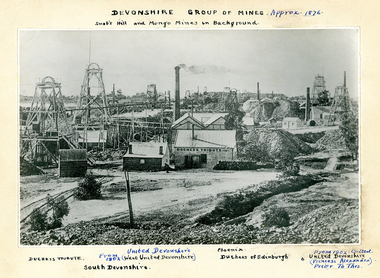
Photograph - SNOBS HILL AND MUNGO MINE IN BACKGROUND, 1876
... Snob's Hill and Mungo Mines in background, Duchess Tribute, United Devonshire, from 1902 (West United Devonshire), South Devonshire, Pheonix, Duchess of Edinburgh. From 1902 called United Devonshire (Princess Alexandra) prior to this. In image 'Duchess Tribute'. On weatherboard...Snob's Hill and Mungo Mines in background, Duchess Tribute, United Devonshire, from 1902 (West United Devonshire), South Devonshire, Pheonix, Duchess of Edinburgh. From 1902 called United Devonshire (Princess Alexandra) prior to this. In image 'Duchess Tribute'. On weatherboard ...Black and white photograph on cream board. View across mining area showing at least 9 poppet heads, 11 chimneys and many bujildings associated with the mines. C-L flume, wood stacks, mullock heaps. Text on photograph: MNG 69 on TL corner. Devonshire Group of Mines - Approximately 1876. Snob's Hill and Mungo Mines in background, Duchess Tribute, United Devonshire, from 1902 (West United Devonshire), South Devonshire, Pheonix, Duchess of Edinburgh. From 1902 called United Devonshire (Princess Alexandra) prior to this. In image 'Duchess Tribute'. On weatherboard building at C.place, mining site, see also 2000 - 426.1, 2000 - 437.01, 2000 - 438.01, 2000 - 439.01, 2000 - 507.01, 2000 - 508.01, 2000 - 509.01 -
 Bendigo Historical Society Inc.
Photograph - T C WATTS & SON COLLECTION: 17 STERNBERG STREET, BENDIGO, 1928
... Hill to Edward and Helen (nee Dietz) Binns. He was a salesman and lived at 17 Sternberg Street with his wife Eva Mabel (nee Court) who he married in 1926. They had previously lived at 53 Williamson Street, Bendigo. BENDIGO Business T C Watts and Son Binns Black and white photograph mounted on rectangular brown board. House, tiled hipped roof. With large portico and brick and concrete pillared verandah. Double front door two double hung windows. Weatherboard ...Edward Claude Binns (1900-1979) was born in Swan Hill to Edward and Helen (nee Dietz) Binns. He was a salesman and lived at 17 Sternberg Street with his wife Eva Mabel (nee Court) who he married in 1926. They had previously lived at 53 Williamson Street, Bendigo.Black and white photograph mounted on rectangular brown board. House, tiled hipped roof. With large portico and brick and concrete pillared verandah. Double front door two double hung windows. Weatherboard and rough cast. Woven wire fence. On back of photo:' T.C. Watts & Son, Ted Binns (name unclear) Sternberg St., October 1928. Dr. Gretton-Watson, tenant at 35/- week, 5 rooms and sleepout. Mrs. C. Morris Owner £2750, gas heater' On front of photo, written in pen ' 17 Sternberg Street'.bendigo, business, t c watts and son, binns -
 Bendigo Historical Society Inc.
Photograph - T C WATTS & SON COLLECTION: RODNEY STREET, BENDIGO, 1930
... Hill, but by 1925 they were registered as living on the corner of Rodney and Reginald Street with their son Frederick Steele McNair Ferguson and his wife Amelia, and later with their daughter Maude. It appears the family continued to live at this address following Frederick snrs death. Frederick and his son Frederick jnr were wool merchants. BENDIGO Business T C Watts & Son Frank A. Jeffree Bendigo Black and white photograph mounted on rectangular brown board. House, weatherboard ...Frederick Steele Ferguson (1861-1938) married Beatrice O'Brien in 1898. Originally they lived at 19 Brodie Street, Quarry Hill, but by 1925 they were registered as living on the corner of Rodney and Reginald Street with their son Frederick Steele McNair Ferguson and his wife Amelia, and later with their daughter Maude. It appears the family continued to live at this address following Frederick snrs death. Frederick and his son Frederick jnr were wool merchants.Black and white photograph mounted on rectangular brown board. House, weatherboard and rough cast, verandah with brick balustrade and rough cast pillars, corrugated iron roof, 1 chimney with 2 pots, double front door, small bay window at RH side, bay window under verandah, sleepout/sunroom attached at back right, established garden, concrete path, hedge at front, woven crinkled wire fence. On back of photo' F. Ferguson, £1800 corner Rodney and Reginald Streets, 15.4.30 corner Rodney and Reginald Streets. 2012 photo of house attached to record.Frank A. Jeffree Bendigobendigo, business, t c watts & son -
 Bendigo Historical Society Inc.
Photograph - T C WATTS & SON COLLECTION: WHITE HILLS, NEXT TO CATHOLIC SCHOOL, 1927
... weatherboard , triple gabled corrugated iron roof, single chimney , wooden return verandah with balustrade, capitals to verandah posts. Exterior windows have awnings, two entrances from returned verandah, two deckchairs and hammock on verandah. Rock-bordered garden R.H. corner. Written on back of photo ' Roberts, White Hills...Hills T.C. Watts and Son 1927 F.A. Jeffree, Bendigo Black and white photograph mounted on rectangular brown board. House, weatherboard ...BHS CollectionBlack and white photograph mounted on rectangular brown board. House, weatherboard , triple gabled corrugated iron roof, single chimney , wooden return verandah with balustrade, capitals to verandah posts. Exterior windows have awnings, two entrances from returned verandah, two deckchairs and hammock on verandah. Rock-bordered garden R.H. corner. Written on back of photo ' Roberts, White Hills, £1150 (crossed out) £850, next R.C. School'F.A. Jeffree, Bendigoresidential, roberts, white hills, t.c. watts and son, 1927 -
 Bendigo Historical Society Inc.
Photograph - T C WATTS & SON COLLECTION: PLUMRIDGE STREET, WHITE HILLS, Approx. 1900-35
... weatherboard, corrugated iron roof. Bull nose veranda painted with stripes, picket fence, two wrought iron gates, one chimney, central door, one window each side of door. Three boards painted white, half way up front wall. Pergola on RH side of house. Tank stand LH side middle distance, name of house to left of door. 'Phillips, Plumridge Street, White Hills...weatherboard, corrugated iron roof. Bull nose veranda painted with stripes, picket fence, two wrought iron gates, one chimney, central door, one window each side of door. Three boards painted white, half way up front wall. Pergola on RH side of house. Tank stand LH side middle distance, name of house to left of door. 'Phillips, Plumridge Street, White Hills ...Thomas Crouch Watts was born on March 7th. 1865, to Joseph and Susan Watts. Before the real estate business commenced, Thomas and his brother were in partnership as booksellers and stationers in a shop at View Point. Thomas lived in a fine house in Rowan Street, which was called 'Ottawa' Thomas started his real estate business in the early 1900s in a shop in View Street. His daughter Edna was the book keeper and typist, Stewart Watson was the salesman and Stanley Phipps (Edith Lunn's father) was the property manager and valuer. When Thomas Watts died in 1914, his daughter took over the running of the business. She married Stewart Watson in 1918. Eventually the name of the business was changed to Bishop and Earl. From a letter from Edith Lunn re T.C. Watts & Son. 'The firm of T.C. Watts & Son later became Bishop and Earl. When the firm of Bishop and Earl ceased to operate after the death of Edith Lunn's father, S.P. Bishop, Miss. June Parry, Secretary of the BHS was a member of staff. June rescued all the photos of properties listed for sale from the office and placed them into the custody of the BHS.' Black and white photograph mounted on rectangular grey board. House, weatherboard, corrugated iron roof. Bull nose veranda painted with stripes, picket fence, two wrought iron gates, one chimney, central door, one window each side of door. Three boards painted white, half way up front wall. Pergola on RH side of house. Tank stand LH side middle distance, name of house to left of door. 'Phillips, Plumridge Street, White Hills' written on back of photo board. 2012 photo of house attached to record.Frank A. Jeffree, Bendigoplace, building, residential -
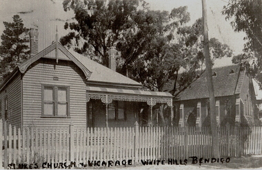 Bendigo Historical Society Inc.
Photograph - ST LUKE'S ANGLICAN VICARAGE AND CHURCH, WHITE HILLS, c.1920
... weatherboard double-fronted house, decorative ? Boards, verandah lacework, decorative brick chimneys ??. Roof, double-hung windows. Brick church adjacent, vented slate roof, buttressed walls, Gothic windows. Picket fence along footpath. SEC? pole. Trees in background. Inscriptions: on front in Indian ink written across bottom of image 'St Luke's Church and vicarage, White Hills...History House 11 Mackenzie Street Bendigo goldfields BUILDINGS Church st lukes white hills Copy of black and white photograph showing view of weatherboard double-fronted house, decorative ? ...Copy of black and white photograph showing view of weatherboard double-fronted house, decorative ? Boards, verandah lacework, decorative brick chimneys ??. Roof, double-hung windows. Brick church adjacent, vented slate roof, buttressed walls, Gothic windows. Picket fence along footpath. SEC? pole. Trees in background. Inscriptions: on front in Indian ink written across bottom of image 'St Luke's Church and vicarage, White Hills Bendigo'.buildings, church, st lukes, white hills -
 The Beechworth Burke Museum
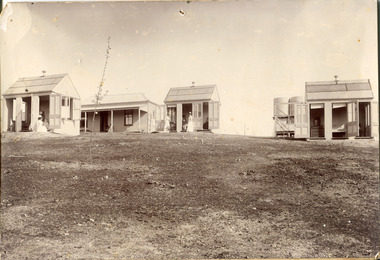
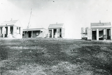
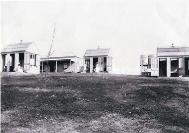
Photograph
... Within the image are weatherboard buildings, a number of nurses and water tanks. Beechworth's Mayday Hills was chosen as the site of Victoria's newest asylum, at the time, due to the landscape and altitude. ...Within the image are weatherboard buildings, a number of nurses and water tanks. Beechworth's Mayday Hills was chosen as the site of Victoria's newest asylum, at the time, due to the landscape and altitude. ...This photograph was captured in approximately 1900 and depicts the on site nurses homes. During the 1880s, these detached cottages were constructed and provided accommodation for the staff (in this case, the nurses) who lived within the hospital walls. Within the image are weatherboard buildings, a number of nurses and water tanks. Beechworth's Mayday Hills was chosen as the site of Victoria's newest asylum, at the time, due to the landscape and altitude. The hilltop atmosphere and the native fauna, it was argued, would assist in the cure of the patients kept at the hospital (Wood 1985, 122). The positioning of the hospital had a beneficial effect on the rural town. A pamphlet published by James Ingram and Son (1849) reveal that famous landmarks in Beechworth which included the Post Office, Gaol, Courthouse and Asylum "demonstrate the appreciation of Beechworth by the Government not only as as important district center, but also as a site unrivaled as a sanitarium". There were other locations in contention at the time, but ultimately Beechworth was chosen (Craig 2000, 33). Prior to the creation of the Asylum in Beechworth, those charged with having mental illnesses or, as it was termed, "insanity" were unable to be properly cared for in the Gaol (which is where they were often sent). John Buckley Castieau wrote, in 1861 for the Ovens and Murray Advertiser, that the Gaol was unable to properly care for those classified then as "insane" but that they would endeavor to treat them above the other inmates (which he notes is not always the case in other establishments). Castieau wrote this in favour of supporting the building of the Mayday Hills Hospital in Beechworth. It was stated that at the time the Mayday Hills Hospital was built, there were 83 prisoners kept in the Gaol who were to be rehoused to the Hospital on the grounds of "insanity". The classification as someone as "insane", in this period of time is a reflection on the inability to cure and understand illnesses of the mind during the mid to late 1800s. Opening on the 24th of October 1867, the Mayday Hills Hospital was originally named the "Ovens Lunatic Asylum", a title which is very much a product of its time. Whilst controversial, changes to the name is part of the history of the Hospital and can provide much insight into the understanding of mental illness throughout history and the use/disuse of this term provides information into the reception/changing opinions of mental illness in society. The Hospital would later become known as the "Mayday Hills Asylum" and/or "Mayday Hills Hospital" with the latter being the most commonly used title. An article in the Ovens and Murray Advertiser notes that on the 7th of March 1865, the foundation stone of the Hospital was laid (it would officially open in 1867) and that it was such a moment of accomplishment and joy for Beechworth that a letter to the editor even suggested that there should be a holiday dedicated to the day the foundation stone as laid. This reveals an extent to which the townspeople of early Beechworth valued the construction of the Hospital in their town. It provided the town with a sense of prestige and honour.At first glance, the remains of the Mayday Hills Hospital in Beechworth, Victoria, inspire tragedy, trauma and beauty. The buildings themselves, with their Italianate style Renaissance architecture designed by J.J. Clark (Craig 2000, 49 & Smith 2016, 203) reflect a bygone period of European and Australian history. The gardens provide a sense of tranquility and beauty. The experience of those within these walls remains a valuable area of study to provide a more complete understanding. This particular hospital is considered the fourth of its like and one of three identified as the largest of their kind. The Mayday Hills Hospital is a sister to the Kew and Ararat Asylums in Melbourne which are both located in relative proximity. Understanding the role of the Mayday Hills Hospital in Beechworth history is integral to understanding the development of the goldfields town, but also for providing important information as to the history of caring for, and the reception of, mental illnesses in Australian and wider European history. Mayday Hills provides a case study which can be researched through oral history, an analysis of the grounds/buildings and through images like these. Images like these depict the strong façade of the Hospital and provide a glimpse into the tranquility of the gardens. This has been done deliberately to provide a sense of comfort and healing about the building to those looking from the outside. Further research into the importance of the Hospital in Beechworth and it's connection to the town will be supported through images like these kept in the Mayday Hills photo album in the collection of the Burke Museum.Black and white rectangular photograph printed on photographic paper mounted on card"Early nurses quarters, Beechworth Mental Hospital, now May Day Hills Hospital."may day hills hospital, nurses quarters, beechworth, mayday hills, asylum -
 The Beechworth Burke Museum
Photograph
... Within the image are weatherboard buildings, a number of nurses and water tanks. Beechworth's Mayday Hills was chosen as the site of Victoria's newest asylum, at the time, due to the landscape and altitude. ...Within the image are weatherboard buildings, a number of nurses and water tanks. Beechworth's Mayday Hills was chosen as the site of Victoria's newest asylum, at the time, due to the landscape and altitude. ...These images are copies of a photograph (3448) captured in approximately 1900 and depicts the on site nurses homes. During the 1880s, these detached cottages were constructed and provided accommodation for the staff (in this case, the nurses) who lived within the hospital walls. Within the image are weatherboard buildings, a number of nurses and water tanks. Beechworth's Mayday Hills was chosen as the site of Victoria's newest asylum, at the time, due to the landscape and altitude. The hilltop atmosphere and the native fauna, it was argued, would assist in the cure of the patients kept at the hospital (Wood 1985, 122). The positioning of the hospital had a beneficial effect on the rural town. A pamphlet published by James Ingram and Son (1849) reveal that famous landmarks in Beechworth which included the Post Office, Gaol, Courthouse and Asylum "demonstrate the appreciation of Beechworth by the Government not only as as important district center, but also as a site unrivaled as a sanitarium". There were other locations in contention at the time, but ultimately Beechworth was chosen (Craig 2000, 33). Prior to the creation of the Asylum in Beechworth, those charged with having mental illnesses or, as it was termed, "insanity" were unable to be properly cared for in the Gaol (which is where they were often sent). John Buckley Castieau wrote, in 1861 for the Ovens and Murray Advertiser, that the Gaol was unable to properly care for those classified then as "insane" but that they would endeavor to treat them above the other inmates (which he notes is not always the case in other establishments). Castieau wrote this in favour of supporting the building of the Mayday Hills Hospital in Beechworth. It was stated that at the time the Mayday Hills Hospital was built, there were 83 prisoners kept in the Gaol who were to be rehoused to the Hospital on the grounds of "insanity". The classification as someone as "insane", in this period of time is a reflection on the inability to cure and understand illnesses of the mind during the mid to late 1800s. Opening on the 24th of October 1867, the Mayday Hills Hospital was originally named the "Ovens Lunatic Asylum", a title which is very much a product of its time. Whilst controversial, changes to the name is part of the history of the Hospital and can provide much insight into the understanding of mental illness throughout history and the use/disuse of this term provides information into the reception/changing opinions of mental illness in society. The Hospital would later become known as the "Mayday Hills Asylum" and/or "Mayday Hills Hospital" with the latter being the most commonly used title. An article in the Ovens and Murray Advertiser notes that on the 7th of March 1865, the foundation stone of the Hospital was laid (it would officially open in 1867) and that it was such a moment of accomplishment and joy for Beechworth that a letter to the editor even suggested that there should be a holiday dedicated to the day the foundation stone as laid. This reveals an extent to which the townspeople of early Beechworth valued the construction of the Hospital in their town. It provided the town with a sense of prestige and honour.At first glance, the remains of the Mayday Hills Hospital in Beechworth, Victoria, inspire tragedy, trauma and beauty. The buildings themselves, with their Italianate style Renaissance architecture designed by J.J. Clark (Craig 2000, 49 & Smith 2016, 203) reflect a bygone period of European and Australian history. The gardens provide a sense of tranquility and beauty. The experience of those within these walls remains a valuable area of study to provide a more complete understanding. This particular hospital is considered the fourth of its like and one of three identified as the largest of their kind. The Mayday Hills Hospital is a sister to the Kew and Ararat Asylums in Melbourne which are both located in relative proximity. Understanding the role of the Mayday Hills Hospital in Beechworth history is integral to understanding the development of the goldfields town, but also for providing important information as to the history of caring for, and the reception of, mental illnesses in Australian and wider European history. Mayday Hills provides a case study which can be researched through oral history, an analysis of the grounds/buildings and through images like these. Images like these depict the strong façade of the Hospital and provide a glimpse into the tranquility of the gardens. This has been done deliberately to provide a sense of comfort and healing about the building to those looking from the outside. Further research into the importance of the Hospital in Beechworth and it's connection to the town will be supported through images like these kept in the Mayday Hills photo album in the collection of the Burke Museum.Black and white rectangular photograph printed on gloss photographic papermental hospital, mayday hills, beechworth, copy, nurse, nurses quarters, on-site dwelling, 1900s, 1880, beechworth asylum -
 The Beechworth Burke Museum
Photograph
... Within the image are weatherboard buildings, a number of nurses and water tanks. Beechworth's Mayday Hills was chosen as the site of Victoria's newest asylum, at the time, due to the landscape and altitude. ...Further research into the importance of the Hospital in Beechworth and it's connection to the town will be supported through images like these kept in the Mayday Hills photo album in the collection of the Burke Museum. mayday hills nurse weatherboard watertank mayday hills hospital asylum mental health kew ararat mental hospital beechworth gold town Black and white rectangular photograph printed on photographic paper mounted on card Photograph Photograph ...This photograph is a copy of that captured in approximately 1900 and depicts the on site nurses homes. During the 1880s, these detached cottages were constructed and provided accommodation for the staff (in this case, the nurses) who lived within the hospital walls. Within the image are weatherboard buildings, a number of nurses and water tanks. Beechworth's Mayday Hills was chosen as the site of Victoria's newest asylum, at the time, due to the landscape and altitude. The hilltop atmosphere and the native fauna, it was argued, would assist in the cure of the patients kept at the hospital (Wood 1985, 122). The positioning of the hospital had a beneficial effect on the rural town. A pamphlet published by James Ingram and Son (1849) reveal that famous landmarks in Beechworth which included the Post Office, Gaol, Courthouse and Asylum "demonstrate the appreciation of Beechworth by the Government not only as as important district center, but also as a site unrivaled as a sanitarium". There were other locations in contention at the time, but ultimately Beechworth was chosen (Craig 2000, 33). Prior to the creation of the Asylum in Beechworth, those charged with having mental illnesses or, as it was termed, "insanity" were unable to be properly cared for in the Gaol (which is where they were often sent). John Buckley Castieau wrote, in 1861 for the Ovens and Murray Advertiser, that the Gaol was unable to properly care for those classified then as "insane" but that they would endeavor to treat them above the other inmates (which he notes is not always the case in other establishments). Castieau wrote this in favour of supporting the building of the Mayday Hills Hospital in Beechworth. It was stated that at the time the Mayday Hills Hospital was built, there were 83 prisoners kept in the Gaol who were to be rehoused to the Hospital on the grounds of "insanity". The classification as someone as "insane", in this period of time is a reflection on the inability to cure and understand illnesses of the mind during the mid to late 1800s. Opening on the 24th of October 1867, the Mayday Hills Hospital was originally named the "Ovens Lunatic Asylum", a title which is very much a product of its time. Whilst controversial, changes to the name is part of the history of the Hospital and can provide much insight into the understanding of mental illness throughout history and the use/disuse of this term provides information into the reception/changing opinions of mental illness in society. The Hospital would later become known as the "Mayday Hills Asylum" and/or "Mayday Hills Hospital" with the latter being the most commonly used title. An article in the Ovens and Murray Advertiser notes that on the 7th of March 1865, the foundation stone of the Hospital was laid (it would officially open in 1867) and that it was such a moment of accomplishment and joy for Beechworth that a letter to the editor even suggested that there should be a holiday dedicated to the day the foundation stone as laid. This reveals an extent to which the townspeople of early Beechworth valued the construction of the Hospital in their town. It provided the town with a sense of prestige and honour.At first glance, the remains of the Mayday Hills Hospital in Beechworth, Victoria, inspire tragedy, trauma and beauty. The buildings themselves, with their Italianate style Renaissance architecture designed by J.J. Clark (Craig 2000, 49 & Smith 2016, 203) reflect a bygone period of European and Australian history. The gardens provide a sense of tranquility and beauty. The experience of those within these walls remains a valuable area of study to provide a more complete understanding. This particular hospital is considered the fourth of its like and one of three identified as the largest of their kind. The Mayday Hills Hospital is a sister to the Kew and Ararat Asylums in Melbourne which are both located in relative proximity. Understanding the role of the Mayday Hills Hospital in Beechworth history is integral to understanding the development of the goldfields town, but also for providing important information as to the history of caring for, and the reception of, mental illnesses in Australian and wider European history. Mayday Hills provides a case study which can be researched through oral history, an analysis of the grounds/buildings and through images like these. Images like these depict the strong façade of the Hospital and provide a glimpse into the tranquility of the gardens. This has been done deliberately to provide a sense of comfort and healing about the building to those looking from the outside. Further research into the importance of the Hospital in Beechworth and it's connection to the town will be supported through images like these kept in the Mayday Hills photo album in the collection of the Burke Museum.Black and white rectangular photograph printed on photographic paper mounted on cardmayday hills, nurse, weatherboard, watertank, mayday hills hospital, asylum, mental health, kew, ararat, mental hospital, beechworth, gold town -
![Photograph - Digital image, House St Helena and Diamond Creek Roads [Greensborough], 02/05/2013](/media/collectors/4f729f5697f83e03086015b8/items/5729bbd22162f108e8de5be2/item-media/5729bc112162f108e8de617d/item-fit-380x285.jpg?cb=6) Greensborough Historical Society
Greensborough Historical SocietyPhotograph - Digital image, House St Helena and Diamond Creek Roads [Greensborough], 02/05/2013
... These photographs of the house on the corner of St Helena and Diamond Creek Roads was taken in 2013 to show changes over 40 years, based on Ron Reynold's sketches in the 1973 publication 'Greensborough and Greenhills' published by Cypress Books... which states "Built on a steep hill in a bush setting in the early 1920s, for a Dr Wood, the weatherboard house now overlooks an area of activity and change. ...Greensborough Historical Society 34A Glenauburn Road Lower Plenty Lower Plenty melbourne These photographs of the house on the corner of St Helena and Diamond Creek Roads was taken in 2013 to show changes over 40 years, based on Ron Reynold's sketches in the 1973 publication 'Greensborough and Greenhills' published by Cypress Books... which states "Built on a steep hill in a bush setting in the early 1920s, for a Dr Wood, the weatherboard house now overlooks an area of activity and change. ...These photographs of the house on the corner of St Helena and Diamond Creek Roads was taken in 2013 to show changes over 40 years, based on Ron Reynold's sketches in the 1973 publication 'Greensborough and Greenhills' published by Cypress Books... which states "Built on a steep hill in a bush setting in the early 1920s, for a Dr Wood, the weatherboard house now overlooks an area of activity and change. The owners, Mr and Mrs E. 'Bluey' Blackburn, remember when their 3/4 acre building block dropped to the edge of a dirt road. Today the view from the high verandah encompasses the Main Street shopping centre, new and old bridges, new roads and houses, the Plenty River, natural bush, hills and sports grounds."Digital copy of colour photograph.greensborough and greenhills, st helena road greensborough, diamond creek road greensborough, wood family, ron reynolds -
 Halls Gap & Grampians Historical Society
Postcard - B/W, C 1940s
... A weatherboard house surrounded by a 'chicken wire' fence. There is a wooded hill in the background....BUILDINGS Houses A weatherboard house surrounded by a 'chicken wire' fence. There is a wooded hill in the background. ...This is the Warren Street residence of the owners of the bakery, which was situated behind this building. The owners were John and Florence Warren who ran the bakery until the 1960's when it was taken over by their daughter Ida and son-in-law Robert Greer. A weatherboard house surrounded by a 'chicken wire' fence. There is a wooded hill in the background.buildings, houses -
 Halls Gap & Grampians Historical Society
Photograph - Coloured, C 1960s
... weatherboard house with an attached garage. A man and three children are standing in front of the house and a dark coloured car can be vaguely seen in the garage. To the left there is the edge of a building with a large ice-cream sign attached and to the right there is a shed set slightly back from the building and the edge of another building. There are wooded hills...weatherboard house with an attached garage. A man and three children are standing in front of the house and a dark coloured car can be vaguely seen in the garage. To the left there is the edge of a building with a large ice-cream sign attached and to the right there is a shed set slightly back from the building and the edge of another building. There are wooded hills ...A house on the main street in Halls Gap. Photograph of a weatherboard house with an attached garage. A man and three children are standing in front of the house and a dark coloured car can be vaguely seen in the garage. To the left there is the edge of a building with a large ice-cream sign attached and to the right there is a shed set slightly back from the building and the edge of another building. There are wooded hills in the backgroundbuildings, houses -
Halls Gap & Grampians Historical Society
Photograph - B/W, C 1920s
... weatherboard house, with a group of eight men and three dogs standing beside it, on the side of a large lake (Lake Wartook). The house is on a platform, built up with stones and there is a stone pillar with platform leading to it in the lake to the right of the men. There is bush with hills...weatherboard house, with a group of eight men and three dogs standing beside it, on the side of a large lake (Lake Wartook). The house is on a platform, built up with stones and there is a stone pillar with platform leading to it in the lake to the right of the men. There is bush with hills ...The house in the photo is the caretaker's residence at Lake Wartook. The men and dogs are standing next to the intake tower.The photo shows a small weatherboard house, with a group of eight men and three dogs standing beside it, on the side of a large lake (Lake Wartook). The house is on a platform, built up with stones and there is a stone pillar with platform leading to it in the lake to the right of the men. There is bush with hills rising above them in the background.scenery, lake wartook -
 Phillip Island and District Historical Society Inc.
Photograph, Early 1900's
... Black & White photograph of a double fronted weatherboard house with wrought iron frieze on verandah. Two ladies standing on verandah. Property named "Oak Hill" owned by the Bonwick Family, San Remo...Phillip Island and District Historical Society Inc. phillip-island-and-the-bass-coast Donated by Jessie Smith oak hill san remo jessie smith On back: "Oak Hill" Black & White photograph of a double fronted weatherboard house with wrought iron frieze on verandah. ...Donated by Jessie SmithBlack & White photograph of a double fronted weatherboard house with wrought iron frieze on verandah. Two ladies standing on verandah. Property named "Oak Hill" owned by the Bonwick Family, San RemoOn back: "Oak Hill"oak hill san remo, jessie smith