Showing 5 items matching "willow avenue"
-
 Sunshine and District Historical Society Incorporated
Administrative record - City of Sunshine - Commissioner Mr Alexander Alex George Gillon Collection 1976 - 1982 - Extraordinary business 25th November 1980, City of Sunshine, 25th November 1980
... ...Willow Avenue...Gas Storage Lots 2 & 5 Frederick Street Brooklyn Planning Permit Application Ployester Plant Extension Monsanto Somerville Road Footscray West Planning Permit Application Factory Alterations Tasman UEB Geelong Road Brooklyn Planning Permit Application Factory and Office cnorner Frederick Street and Justin Street Brooklyn Planning Permit Application 4 Flats Mark Street Sunshine West Planning Permit Application Transport Depot 457 Somerville Road Brooklyn Planning Permit Application Factory Frederick Street Brookyln Planning Permit Application Extensions to Factory amended plan Lots 1, 2 and 86 corner Henderson Street and Berkshire Road Sunshine North Planning Permit Application Transport Depot Calleja Transport Pty Ltd 552 Geelong Road Brooklyn Location of Building 2 Willow Avenue St. Albans...Meggit Ltd Somerville Road Brooklyn Bell Street Sunshine West Glengala Road McDonald Road McIntyre Road Sunshine North McGrath Duke Street Frederick Street Monsanto Footscray West Tasman UEB Geelong Road Justin Street Mark Street Henderson Street Berkshire Road Willow Avenue St. Albans Planning Permit Application Vegetable Oil tank Meggit Ltd Somerville Road Brooklyn Planning Permit Application Construction of garage Bell Street Sunshine West Planning Permit Application Extension to Cafe 99 Glengala Road Sunshine West Planning Permit Application Offices Lots 2, 3, and 4 McDonald Road Brooklyn Planning Permit Application Promotion Sign McIntyre Road Sunshine North Planning Permit Application Amenities Block J. ...Planning Permit Application Vegetable Oil tank Meggit Ltd Somerville Road Brooklyn Planning Permit Application Construction of garage Bell Street Sunshine West Planning Permit Application Extension to Cafe 99 Glengala Road Sunshine West Planning Permit Application Offices Lots 2, 3, and 4 McDonald Road Brooklyn Planning Permit Application Promotion Sign McIntyre Road Sunshine North Planning Permit Application Amenities Block J. J. McGrath Aust Duke Street Sunshine North Planning Permit Application L.P. Gas Storage Lots 2 & 5 Frederick Street Brooklyn Planning Permit Application Ployester Plant Extension Monsanto Somerville Road Footscray West Planning Permit Application Factory Alterations Tasman UEB Geelong Road Brooklyn Planning Permit Application Factory and Office cnorner Frederick Street and Justin Street Brooklyn Planning Permit Application 4 Flats Mark Street Sunshine West Planning Permit Application Transport Depot 457 Somerville Road Brooklyn Planning Permit Application Factory Frederick Street Brookyln Planning Permit Application Extensions to Factory amended plan Lots 1, 2 and 86 corner Henderson Street and Berkshire Road Sunshine North Planning Permit Application Transport Depot Calleja Transport Pty Ltd 552 Geelong Road Brooklyn Location of Building 2 Willow Avenue St. Albansmeggit ltd, somerville road, brooklyn, bell street, sunshine west, glengala road, mcdonald road, mcintyre road, sunshine north, mcgrath, duke street, frederick street, monsanto, footscray west, tasman ueb, geelong road, justin street, mark street, henderson street, berkshire road, willow avenue, st. albans -
 Kew Historical Society Inc
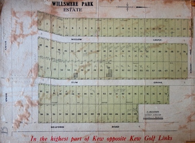
Plan - Subdivision Plan, J R Mathers & McMillan, Willsmere Park Estate, c.1940
... The first subdivision of the Estate included 77 grand allotments with frontages to Belford and Kilby Roads, Elm and Willow Groves, and Acacia Avenue. Every lot was claimed to be ‘high and dry’, and with panoramic views of Kew and East Kew. ...The first subdivision of the Estate included 77 grand allotments with frontages to Belford and Kilby Roads, Elm and Willow Groves, and Acacia Avenue. Every lot was claimed to be ‘high and dry’, and with panoramic views of Kew and East Kew. ...Pru Sanderson, in her groundbreaking ‘City of Kew Urban Conservation Study : Volume 2 - Development History’ (1988), summarised the periods of urban development and subdivisions of land in Kew. The periods that she identified included 1845-1880, 1880-1893, 1893-1921, 1921-1933, 1933-1943, and Post-War Development. These periods were selected as they represented periods of rapid growth or decline in urban development. An obvious starting point for Sanderson’s groupings involved population growth and the associated economic cycles. These cycles also highlighted urban expansion onto land that was predominantly rural, although in other cases it represented the decline and breakup of large estates. A number of the plans in the Kew Historical Society’s collection can also be found in other collections, such as those of the State Library of Victoria and the Boroondara Library Service. A number are however unique to the collection.The Kew Historical Society collection includes almost 100 subdivision plans pertaining to suburbs of the City of Melbourne. Most of these are of Kew, Kew East or Studley Park, although a smaller number are plans of Camberwell, Deepdene, Balwyn and Hawthorn. It is believed that the majority of the plans were gifted to the Society by persons connected with the real estate firm - J. R. Mathers and McMillan, 136 Cotham Road, Kew. The Plans in the collection are rarely in pristine form, being working plans on which the agent would write notes and record lots sold and the prices of these. The subdivision plans are historically significant examples of the growth of urban Melbourne from the beginning of the 20th Century up until the 1980s. A number of the plans are double-sided and often include a photograph on the reverse. A number of the latter are by noted photographers such as J.E. Barnes. In 1910, the Willsmere Park Estate Dairy was lauded in the Box Hill Reporter as ‘an object lesson in dairying’. Ten years later, in 1923, it was to be sold. The first subdivision of the Estate included 77 grand allotments with frontages to Belford and Kilby Roads, Elm and Willow Groves, and Acacia Avenue. Every lot was claimed to be ‘high and dry’, and with panoramic views of Kew and East Kew. The balance of the Estate, and the largest proportion of allotments was to be subdivided and sold from 1940. This second sale included 109 lots fronting Kilby Road and Elm and Willow Groves. Annotations on the plan indicate that the more expensive lots faced Belford Road opposite the Kew Golf Links. Two of these sold for £310. Lots further to the west in Willow Grove were sold for £60 less. Many of the houses to be built on these 109 allotments after the War faced Government restrictions on building materials and the dimensions of each house due to postwar shortages.subdivision plans - east kew, willsmere park estate -
 Glen Eira Historical Society
Document - National Trust Register
... Avenue... Inkerman Street... Iknerman Road... Sandham Street... Selwyn Street... St. Georges Road... Willow...Neerim Road Poplar Grove Avoca Grove Balaclava Road Orrong Road Bambra Road Glen Eira Road Hood Crescent Hawthorn Road Glenferri Street Glenhuntly Road Glen Huntly Road Kambrook Road Kooyong Road Lirrewa Grove Manor Grove North Road Pearson Avenue Seymour Road Alma Road Craddock Avenue Dandenong Road Lyndoch Avenue Orrong Crescent Hotham Street Nagle Avenue Inkerman Street Iknerman Road Sandham Street Selwyn Street St. Georges Road Willow Street Grange Road Station Place Railway Parade Alexandra Street Wood Crescent Elizabeth Street Halstead Street Mavho Street Tucker Road McKinnon Road Nepean Highway Wheatly Road Uniting Church Carnegie Athole St Stephen's Uniting Church Caulfield St Aloysius' Catholic Church Halstead St Mary's Anglican Church Caulfield Caulfield Town Hall Anseln The Glen Woolamai Caulfield House Caulfield Hospital Lirrewa Labassa Fairfield Hall Bellecourt Bagatelle Myoora Rosecraddock Adam and Eve - Karl Duldig The Family - Karl Duldig Caulfield Primary School Septimus Miller Memorial Chapel Brighton Cemetery Hopetoun Gardens State Savings Bank Elsternwick Anderson Organ Hopetoun Private Hospital (Melrose) Rippon Lea Ripponlea Burreel O'Neill College Lisbon House Elsternwick Club Merkin-Schutze Organ Presentation Convent Duldig Mural - Kadimah Cultural Centre Glenmoore Craigellachie St James the Great Glenfern Grimwade House Dacre Trinity Congregational Uniting Church Glenhuntly Alnwick Holmwood New Alexandra Joscelyne Organ Smith Organ Fincham Organ St George's Bentleigh McKinnon Progress Hall Wurlitzer Organ Moorabbin Town Hall Christ Anglican Church St Mary's Jubilee School St Stephen's Presbyterian Church Elsternwick Congregational Church St Mary's Church of England Former Metropolitan Fire Brigade Station No. 31 St Mary's Jubilee Church Belle Court Trinity Congregational Church Heatherbrae Carnegie Caulfield Caulfield North Caulfield South Elsternwick Glen Huntly Glenhuntly Murrumbeena St Kilda East Bentleigh McKinnon Moorabbin Ormond National Trust of Australia National Trust Register Houses Churches Schools Organs Vallati Gladys Mansions Document National Trust Register ...This file contains two items relating to historic buildings in Glen Eira listed on the National Trust Registry: 1/A fax, sent to Gladys Vallati on 02/03/1995 from the National Trust of Australia listing buildings on the Trust’s registry in the Glen Eira area, as well as their addresses and status on the register (5 pages). (Additional photocopy taken for preservation purposes). 2/A typed list of buildings in the Glen Eira area (mainly Caulfield) which are on the National Trust list, including address, approximate date of construction and status on the register. Date of production of the list is unknown. (6 pages).neerim road, poplar grove, avoca grove, balaclava road, orrong road, bambra road, glen eira road, hood crescent, hawthorn road, glenferri street, glenhuntly road, glen huntly road, kambrook road, kooyong road, lirrewa grove, manor grove, north road, pearson avenue, seymour road, alma road, craddock avenue, dandenong road, lyndoch avenue, orrong crescent, hotham street, nagle avenue, inkerman street, iknerman road, sandham street, selwyn street, st. georges road, willow street, grange road, station place, railway parade, alexandra street, wood crescent, elizabeth street, halstead street, mavho street, tucker road, mckinnon road, nepean highway, wheatly road, uniting church carnegie, athole, st stephen's uniting church caulfield, st aloysius' catholic church, halstead, st mary's anglican church caulfield, caulfield town hall, anseln, the glen, woolamai, caulfield house, caulfield hospital, lirrewa, labassa, fairfield hall, bellecourt, bagatelle, myoora, rosecraddock, adam and eve - karl duldig, the family - karl duldig, caulfield primary school, septimus miller memorial chapel, brighton cemetery, hopetoun gardens, state savings bank elsternwick, anderson organ, hopetoun private hospital (melrose), rippon lea, ripponlea, burreel, o'neill college, lisbon house, elsternwick club, merkin-schutze organ, presentation convent, duldig mural - kadimah cultural centre, glenmoore, craigellachie, st james the great, glenfern, grimwade house, dacre, trinity congregational uniting church glenhuntly, alnwick, holmwood, new alexandra, joscelyne organ, smith organ, fincham organ, st george's bentleigh, mckinnon progress hall, wurlitzer organ, moorabbin town hall, christ anglican church, st mary's jubilee school, st stephen's presbyterian church, elsternwick congregational church, st mary's church of england, former metropolitan fire brigade station no. 31, st mary's jubilee church, belle court, trinity congregational church, heatherbrae, carnegie, caulfield, caulfield north, caulfield south, elsternwick, glen huntly, glenhuntly, murrumbeena, st kilda east, bentleigh, mckinnon, moorabbin, ormond, national trust of australia, national trust register, houses, churches, schools, organs, vallati gladys, mansions -
 University of Melbourne, Burnley Campus Archives
Photograph - Black and white print, Driveway to Principal's Residence, 1947
... avenue was lined with pine trees some of which survive." T.H. Kneen. lily ponds driveway green grows our garden a.p. winzenried principal's residence luffmann ponds pine trees On reverse, "Late Sept. 1947. Drive to house with pond & willows ...Appears as an illustration in, "Green Grows Our Garden, A.P. Winzenried p 77. Removed, after the Principals Residence was taken down, in 1980. "This narrow path replaced an earlier avenue which led up to the Curator's house (later Principal's Residence) . The avenue was lined with pine trees some of which survive." T.H. Kneen.Black and white photograph. Lily Ponds to the right of the driveway.On reverse, "Late Sept. 1947. Drive to house with pond & willows (pruned). Drive curves to left."lily ponds, driveway, green grows our garden, a.p. winzenried, principal's residence, luffmann ponds, pine trees -
 Melton City Libraries
Map, Streets of Melton, 1963
... DUNVEGAN Circuit Home of the McPherson family, castle Isle of Skye Name of bluestone house Smith Street (now at Willows) EMIL Court Jongebloed family EXELL Avenue Farming family Melton Sth- Closer Settlement 1907 EXFORD Road Exe former name of the Werribee river FARMER Court Name of early postmistress FERRIS Road John Ferris Farmer HANNAH Close First name of Hannah Watts – midwife HAYBALE Place Agricultural HELDER Court Early surveyor J Helder Wedge map HEWSON Street Winston Hewson Shire Engineer – check title c 1960 HENRY Street Township map c 1860 HESTON Street Heston Phoenix – C.J. ...DUNVEGAN Circuit Home of the McPherson family, castle Isle of Skye Name of bluestone house Smith Street (now at Willows) EMIL Court Jongebloed family EXELL Avenue Farming family Melton Sth- Closer Settlement 1907 EXFORD Road Exe former name of the Werribee river FARMER Court Name of early postmistress FERRIS Road John Ferris Farmer HANNAH Close First name of Hannah Watts – midwife HAYBALE Place Agricultural HELDER Court Early surveyor J Helder Wedge map HEWSON Street Winston Hewson Shire Engineer – check title c 1960 HENRY Street Township map c 1860 HESTON Street Heston Phoenix – C.J. ...MELTON’S STREETS Heritage Week 2014 What’s in a Name? Alphabetical List Aboriginal place names, Early Family Names and landowners, Agricultural, Shop and Commercial premises, Places and Events Melton & District Historical Society Street Naming Project 1972 – c 1998 Suburb Name – KURUNJANG - Kirkton, 1972, Brookfield, West, 1988 Melton and Town Centre - A joint collaboration with the Shire of Melton and Subdivision Developers ARNOLD Court – Family house - Arnolds Creek ALKEMADE Drive Family – Lime kilns Coimadia ALEXANDRA Street 1902 – Corination of King Edward VII and Queen Alexandra AVIATOR Place Event, location of plane crash – Jimmy Melrose 1936 Adina ?Annibee - Anniba? Agricultural Avon court .. .. BAKERY Square - Location of Jongebloed shop, bakehouse and stables BALUK Place Aboriginal BARLEYCORN Place Agricultural BILLING Place Name of Jimmy Melrose Uncle Noel Pemberton Billing BLACKWOOD Drive - Alexander Blackwood 1860c Registrar BARRIES Road C. E. Barrie “Darlingsford” farmer 1911, chaff mill owner BROOKLYN Road Staughton family residence. 1875 – Dismantled c 193? CAHILL Drive Family - Glenville Dairy CAMERON Court Family Canopus Place ? CANALLAN Drive Early Surveyor CAMPBELL Court Aviation – Melrose passenger 6th July 1936 CARBERRY Drive Michael, early landowner family CAREW Court Edward and Michael. Royal Hotel. Vera (Carew) Forran Singer - Opera CASEY Court Family CASHIN Court Family CHEVIOT Court Agriculture, breed of sheep CHESNEY Road was re named ( Minns Road being duplicated c 1973) CHRISTINA Crescent Christina McPherson, daughter of James and Mary Mary McPherson. Died 1955 aged 85 years COLLYER Close a deleted street (parallel to Yuille) re-used CORRIEDALE Road Breed of sheep CORR Court Teacher at first school, landowner CROXTON Court Name of the Hornbuckle and Knox family home DALEY Court - William Daley and family 1865 Bootmaker High Street DARLINGSFORD Boulevard - Name of early homestead Thomas B Darling 1853 DJERRIWARRH Court - Parish County of Bourke - very early map. DODEMAIDE Place Early land owners - Melton Football Team had 6 brothers playing c 1924 DONALD Court McPherson family 6 generations in Melton in 1936 DOUGAL Court DUNCAN Court .. .. DUNVEGAN Circuit Home of the McPherson family, castle Isle of Skye Name of bluestone house Smith Street (now at Willows) EMIL Court Jongebloed family EXELL Avenue Farming family Melton Sth- Closer Settlement 1907 EXFORD Road Exe former name of the Werribee river FARMER Court Name of early postmistress FERRIS Road John Ferris Farmer HANNAH Close First name of Hannah Watts – midwife HAYBALE Place Agricultural HELDER Court Early surveyor J Helder Wedge map HEWSON Street Winston Hewson Shire Engineer – check title c 1960 HENRY Street Township map c 1860 HESTON Street Heston Phoenix – C.J. Melrose plane HILDEGARDE Court Jimmy Melrose’s mothers name HOMESTEAD Close HORNBUCKLE Cres Farmers. Three members of family - Shire Presidents HURLEY Street Farmers IAIN Court Descendent of James and Mary McPherson JAMES MELROSE Drive Name appears on 2013 Melton information map JANG Place KURUN – jang KIRKTON Drive Name of the McPherson family home Toolern Vale Road KIRWIN Street Michael early landowners (deleted for freeway construction) KILPATRICKS Road Deleted when Barries Road was extended across Station Rd KOROROIT Court Early map, Parish of Kororoit. Creek name KNOX Circuit Family – Hornbuckle “Croxton Park” KURRUNJANG Drive Aboriginal name for people of the red earth – Suburb name Lara Place ? LLOYD Court Garage owners High Street. Laura lived to 100 years D 1955 LUBY Court John Luby – Crown Grant Land Title LITTLE Court MANNING Avenue Richard, hotel owner 1891 MARGARET Drive McPherson family McDONALD Street Melton South family name McKENZIE Street Township c1860 MORROW Street Early name MOWBRAY Crescent Name of English Melton, popularly believed origin of Melton MYERS Court Early setters c 1866 Crown Grant Land Title NIMMO Street Early name NIXON Street Name submitted by Mary nee Nixon Collins c1985 OLDERSHAW Road Early builder PALMERSTON Street Early township map c 1860 PEART Court Early name PENNYROYAL Avenue Plant growing by the creek. Early name used for the Toolern Toolam Creek PINKERTON Street Family name and early street map PINNACLE Crescent Agricultural - type of wheat PHOENIX Circuit C.J. Melrose Phoenix Heston Plane 2013 map PRATT Family PRIOR Court PYKE Place Brothers – early settlement 1838 RADFORD Court Land owners and business operators. Former Royal Hotel Grocer High Street demolished 1970 RAGLAN Court Hotel 19th century Lord Raglan RALEIGHS Road Oliver Reierson family (Norweigen) Shopkeeper – Dressmakers RIDDELL Drive (misspelt Riddle) Resident and land owner RODERICK Road McPherson family – a re occurring name ROLLAND Court Jones family ROSS Court Daniel. Landowner. Agnes Ross music teacher RUSSELL Court Robert. Early land surveyor of Melton 1853 RYAN Court Family early landowner. Member of the 1862 Road Board SHEBLER Place Augustus early Melton resident – Golden Fleece Hotel SHEEPFOLD Court Farming SHERWIN Court Sherwin Street earliest Township map– became Golf course SMITH Street Early township map. STRATHULLOH Circuit Strathtulloh Homestead. STAUGHTON Street Family – LARGE land owners Strachan ? SWANEY Court Marie Swaney earlier resident of Strathtulloh. SUTHERLAND Family name TOOLERN Street TOOLAM – TOOLERN Creek TULLIDGE St Road marked on 1861 map UNITT Street Early Township c 1860 WALLACE Square Cr Jack Wallace 5 terms as President 46 years unopposed WATTS Court Hannah Watts – midwife, cottage hospital WALSINGHAM Name of house of Minns family. From Walsingham Norfolk England WESTLEY Place Name of Jimmy Melrose Percival Gull Plane WESTLAKE Drive Early resident WHICKHAM Street Family Name Melton South WILSON Road Albert, Melton South YUILLE Street William Cross, early landowner, Rockbank run Zoomed in section of Melton Streets including Church and High Streetlandscapes of significance