Showing 12 items
matching rivers, themes: 'built environment'
-
 Lynda Tieman
S.S. Casino
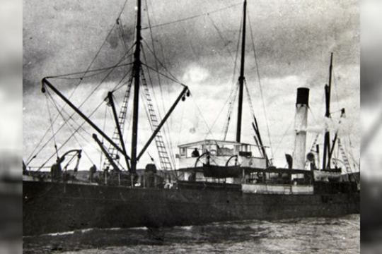
... The steamship SS Casino served the Western District of Victoria for almost fifty years during the late 19th and early 20th centuries. A popular cargo ship, the Casino was a regular sight on the Moyne river and along the coast. The ship ...The steamship SS Casino served the Western District of Victoria for almost fifty years during the late 19th and early 20th centuries.
A popular cargo ship, the Casino was a regular sight on the Moyne river and along the coast. The ship was an integral part of coastal life until she was shipwrecked in the 1930's, and objects from the Casino can now be found in collections from across the region and gathered here on Victorian Collections for the first time.
Transporting large quantities of wool, potatoes, onions, grain, sheep, cattle and other produce provided a great economic opportunity to business men in Port Fairy and in March, 1882, the Belfast & Koroit Steamship Company was formed with a capital of £20,000 in 10,000 shares. The SS Casino on her delivery voyage from England was due in Warrnambool to load potatoes for Sydney and the Directors inspected and purchased her there.
She arrived in Port Fairy on 29th July, 1882, steaming triumphantly up the Moyne River, and was greeted with cheers by a large crowd, many of whom had come from the surrounding countryside. She operated alone for almost all of the next 49 years. She was much loved by the whole Port Fairy community and the coastal ports that she serviced, bringing news and goods from far away and transporting passengers.
A celebration for the Casino's fiftieth anniversary was planned for the 29th July, 1932. Unfortunately soon after 9 o'clock on the morning of Sunday 10th July, 1932, disaster struck when the Casino was lost at Apollo Bay together with the lives of the Captain and 9 crew members.
-
Early Photographs - Landscapes and Streetscapes
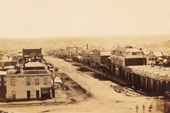
... Yarra River... waterfalls, to the already altered Yarra River, to the dusty corner of Spring and Bourke Streets. Further material can be found at the State Library of Victoria's Ergo site: Early Street Names of Melbourne ...Antoine Fauchery and Richard Daintree's images offer rare fine quality images of early Victorian landscapes and Melbourne streets of the late 1850s.
Antoine Fauchery and Richard Daintree's Sun Pictures of Victoria was the first photographic album of Australian scenes made available for sale to the public.
Using the latest in photographic techniques of the time, the Fauchery-Daintree images offer rare fine quality images of early Victorian landscapes and Melbourne streets of the late 1850s; from pristine waterfalls, to the already altered Yarra River, to the dusty corner of Spring and Bourke Streets.
Further material can be found at the State Library of Victoria's Ergo site: Early Street Names of Melbourne
-
Walhalla: fires, floods and tons of gold
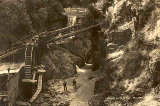
... In a remote, steep, and heavily timbered valley in the Victorian Alps, in the summer of 1862-63, a small party of prospectors found encouraging signs of gold at the fork of a tributary of the Thomson River. It was December. By February of the next ...In a remote, steep, and heavily timbered valley in the Victorian Alps, in the summer of 1862-63, a small party of prospectors found encouraging signs of gold at the fork of a tributary of the Thomson River. It was December. By February of the next year an immense quartz reef had been discovered.
This reef – Cohen’s Reef - yielded over 50 tonnes of gold, making Walhalla one of Victoria’s richest and most vibrant towns, and home to thousands: with hotels, shops, breweries, churches, school, jail and its own newspaper. It also had its own photographic studio, headed by the Lee brothers.
Several albums still survive of Walhalla at its peak, providing a fascinating, evocative photographic record of a 19th century mining town; capturing a moment that was to be shortlived.
In 1910 the railway arrived, but too late: the gold was disappearing. The town emptied out and began its long sleep, until the 1980s when restorations began in earnest, and electricity finally arrived in 1998.
William Joseph Bessell (ex Councillor of the Shire of Walhalla) was presented this series of photos in 1909 on the eve of his departure from Walhalla.
-
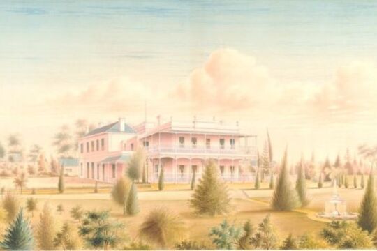
Viewbank: Unearthing a Colonial Homestead
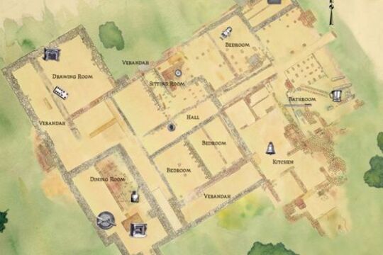
... Viewbank Homestead was one of the first grand homesteads built on the outskirts of Melbourne. Built around 1840, Viewbank was located near the junction of the Yarra and Plenty Rivers in Heidelberg. The homestead was built in two phases. Originally ...Viewbank Homestead was one of the first grand homesteads built on the outskirts of Melbourne. Built around 1840, Viewbank was located near the junction of the Yarra and Plenty Rivers in Heidelberg.
The homestead was built in two phases. Originally a four room house, it was renovated and expanded in the 1850s and 1860s after it was acquired by wealthy squatter Dr Robert Martin.
Viewbank was destroyed by a professional demolition team in the early 1920s, long after the Martin family moved away from the area. By then, the house had fallen into disrepair and locals believed that it was haunted. For most of the 20th century, cattle grazed over the ruins and knowledge of the former grand homestead slipped from public knowledge until archaeologists returned to the site to unlock its secrets.
Between 1996 and 1999, Heritage Victoria conducted three excavations at the site with help from archaeologists from Melbourne, La Trobe and Flinders Universities, and more than 140 archaeology students and community members.
The archaeologists uncovered the stone foundations of the house and remnants of hand-made brick walls, fireplaces and other features. A range of artefacts were found during the excavation including children’s toys, coins, gaming tokens, thimbles and pins. A network of servant’s bells, fragments of marble fireplaces, and pieces of richly decorated plaster cornices reflect the affluence of the Martin family.
This story is made up of audio interviews with an archaeologist, an historian and a conservator. They discuss the Viewbank excavation, describe the artefacts found there and explain the process of their conservation at the Heritage Victoria conservation laboratory.
The Viewbank Homestead is listed on the Victorian Heritage Register. For more information on the Viewbank or other heritage sites visit The Victorian Heritage Database.
-
 Open House Melbourne
Modern Melbourne
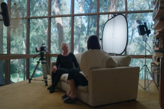
... After completing his education at RMIT and the University of Melbourne, Peter McIntyre went on to design and build one of Melbourne’s most iconic modernist houses, River House, before designing the Melbourne Olympic Swimming pool in 1952...Peter McIntyre purchased the 9-acre block of land in 1947 for £200 when he was 19 years old. The terrain was difficult, with steep cliffs and prone to flooding from the Yarra River. ...Modern Melbourne is a series of filmed interviews and rich archival material that documents the extraordinary lives and careers of some of our most important architects and designers including Peter McIntyre, Mary Featherston, Daryl Jackson, Graeme Gunn, Phyllis Murphy, Allan Powell and Peter Elliott.
Melbourne’s modernist architects and designers are moving into the later stages of their careers. Their influence on the city is strong and the public appreciation of their early work is growing – they have made an indelible mark on Melbourne. Much of their mid-century modernist work and latter projects are now represented on the Victorian Heritage Register.
Many of the Modern Melbourne subjects enjoyed a working relationship and a friendship with Robin Boyd, the influential architect who championed the international modernist movement in Melbourne.
-
 Elizabeth Downes
Tallangatta: The town that moved
... of water after the Hume Dam was expanded. During 1954 the State Rivers and Water Supply Commission took more than 180 photos in and around the town, documenting houses, businesses and facilities before they were moved. Other images capture the remarkable ...Every now and then, when the Hume Dam is at a low ebb, the ghostly remains of old Tallangatta, in northern Victoria, can be seen above the water. Now located 39 kilometres east of Wodonga, Tallangatta is known as 'the town that moved'.
In 1956, 2 hotels, 4 petrol stations, numerous shops and businesses, 4 churches, more than 900 residents and all the usual public amenities of a country town were relocated 8 kilometres west of the old site. The original location was then flooded under 6 feet of water after the Hume Dam was expanded.
During 1954 the State Rivers and Water Supply Commission took more than 180 photos in and around the town, documenting houses, businesses and facilities before they were moved. Other images capture the remarkable feat of transporting the buildings to the new site, such as a weatherboard house being carefully towed toward a narrow bridge. Many photos give a vivid picture of the commercial centre of a small country town in the mid-1950s. Advertising signs promote Sennitts Icecream and The Argus newspaper, cluttered shops are packed to the gunnels with equipment and staples for small town life before large chain stores, supermarkets and cars changed country towns forever.
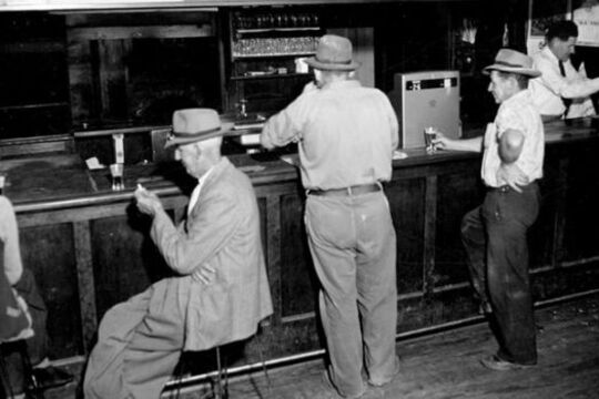
The shops and houses are distributed along straight Towong Street. Cars were scarce and bicycles were an important form of transport in the wide and mostly empty streets. Men and women in the 2 hotels were still segregated in the ladies lounge and main bar; and the hotel’s kitchen equipment was basic. The town offered butchers, barbers, and hairdressers, while the garages, plumbers, and hardware stores served both town and farming needs.
The Tallangatta photographs are part of The Rural Water Corporation Collection of more than 50,000 photographs held at The State Library of Victoria. This collection covers a range of water management projects and activities during the first half of the 20th century.
-
Melbourne and Smellbourne
... Yarra River... (MMBW) was created. It immediately began plans to build an underground drainage system linked to a pumping station at Spotswood, located on the western banks of the mouth of the Yarra River. The sewage flowed by gravity to Spotswood, where ...Over the last 150 years Victoria has experienced a number of landmark capital works and landscaping projects in response to its changing economic, environmental and cultural relationship to water. The sewerage system that we take for granted today had to be built from scratch.
For all the grandeur that was 'Marvellous Melbourne' in the 1880s, the city was nicknamed 'Smellbourne', and for good reason. The building of Yan Yean Reservoir in the 1850s had ensured the availability of fresh water, but there was still no sewerage system.
An appalling stench wafted from the many cesspits and open drains. 'Nightsoil' (as human waste was politely referred to) polluted the streets and ran into the Yarra. Nightsoil collectors frequently dumped their loads on public roads. Ignorance and neglect of the hygienic disposal of human waste had devastating results at this time when hundreds died in a savage outbreak of typhoid.
Melbourne and Metropolitan Board of Works
In 1891 the Melbourne and Metropolitan Board of Works (MMBW) was created. It immediately began plans to build an underground drainage system linked to a pumping station at Spotswood, located on the western banks of the mouth of the Yarra River. The sewage flowed by gravity to Spotswood, where it was then pumped to the Werribee Treatment Farm.
Spotswood Pumping Station
Spotswood Pumping Station built to pump Melbourne's sewage to Werribee, was finished in 1897. At the pumping station, steam engines (later replaced by electrical ones) worked to pump the sewage up a rising main to join the major sewer outfall at the head of the pumping mains near Millers Road at Brooklyn. The outfall sewer then carried the sewage to the Werribee Treatment Farm where it was purified and discharged into the sea.
Werribee Farm
Werribee was the perfect site for the MMBW's new sewage farm. The farm was the Board's most important project, and one of the largest public works undertaken in Australia in the nineteenth century.
Land at Werribee was cheaper than at Mordialloc - the other site considered. Rainfall was low compared with the rest of Melbourne, which meant the land would adapt well to irrigation. Werribee was also 9 miles (14.4 KM) away from the nearest boundary of the metropolitan district (Williamstown), and 24 miles (38.6 KM) away from the influential and well-to-do suburb of Brighton. The Chirnside family sold 8,857 acres (3.2 hectares) to the Board for 17 pounds per acre.
The Earl of Hopetoun, Governor of Victoria, turned the first sod of earth in a ceremony on May 1892, which marked the beginning of the building of the outfall sewer near Werribee.
Connection!
On 5 February 1898, a ceremony marked the official connection of Melbourne to the new sewerage system. Guests - politicians, board members, city councillors and federal delegates - boarded a steamer to watch the Governor, Lord Brassey, raise the penstock (the partition between the smaller and larger sewers) at the Australian Wharf. They then visited the pumping station at Spotswood and the sewage farm at Werribee. Horses and carts conveyed the 180 guests around the farm.
After lunch and toasts, many of which looked forward to the future of a federated Australia, MMBW Chairman Mr Fitzgibbon proudly declared it "was not a question of how much the scheme was going to cost, but how much it was going to save in the lives of the citizens." Before the work was completed he hoped to see those puny punsters and petty wits who spoke of Melbourne as Marvellous Smellbourne constrained to speak of her as one of the sweetest and healthiest cities of the world.
-
 Isaac Douglas Hermann & Heather Arnold
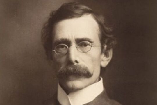
Carlo Catani: An engineering star over Victoria
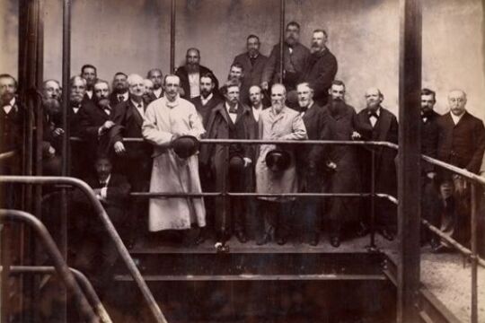
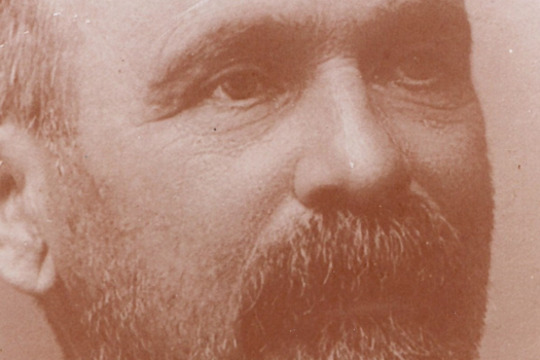
... Map: Yarra River improvements... and progressed to the Public Works Department as an assistant engineer. From there Checchi transferred to the Department of Water Supply, and later to the State Rivers & Water Supply Commission, where his significant achievements concerned Murray River ...After more than forty-one years of public service that never ended with his retirement, through surveying and direct design, contracting, supervision, and collaborative approaches, perhaps more than any other single figure, Carlo Catani re-scaped not only parts of Melbourne, but extensive swathes of Victoria ‘from Portland to Mallacoota’, opening up swamplands to farming, bringing access to beauty spots, establishing new townships, and the roads to get us there.
-
Como House and the Armytage Family
... the property. After the inspection he went straight across the river to Bell and Butt, furniture makers of Richmond, and ordered all the dining-room furniture for Como - two months before the auction. In December, he bought the property for fourteen thousand ...The Armytage family owned Como House in South Yarra for nearly 95 years. The property was managed by the women of the family for more than seventy years from 1876 to 1959. The history of the Armytage family, and the families who worked for them, provides an insight into almost a century of life on a large estate.
Como was purchased in 1864 by Charles Henry Armytage and it became the home of Charles, his wife Caroline, and their ten children. Charles died in 1876 and Caroline in 1909. Their daughters Leila, Constance, and Laura lived on at Como and left an indelible impression there.
The last surviving children of Charles and Caroline - Constance and Leila - sold Como to The National Trust of (Vic) in 1959. Como was the first house acquired by the Trust. One of the most significant aspects of this purchase was the acquisition of the complete contents of the house. The Armytage sisters realized that if Como was to survive as an expression of their family and its lifestyle, it must remain intact as a home. They also left an extensive archive of diaries, letters, journals and photographs.
Boasting one of Melbourne’s finest gardens, an inspiring historic mansion, and an impressive collection of antique furniture, the property provides a glimpse into the privileged lifestyle of its former owners; one of Australia’s wealthiest pioneer families.
Life can be seen to contain two major elements: the animate and the inanimate. While the inanimate bricks and mortar, objects and pathways, help in our understanding of this family, it is the animate, the social history, which makes Como come alive.
The text above has been abstracted from an essay The Armytage Family of Como written by Adrea Fox for the publication The Australian Family: Images and Essays. The entire text of the essay is available as part of this story.
This story is part of The Australian Family project, which involved 20 Victorian museums and galleries. The full series of essays and images are available in The Australian Family: Images and Essays published by Scribe Publications, Melbourne 1998, edited by Anna Epstein. The book comprises specially commissioned and carefully researched essays with accompanying artworks and illustrations from each participating institution.
-
 History Teachers' Association of Victoria / Royal Historical Society of Victoria
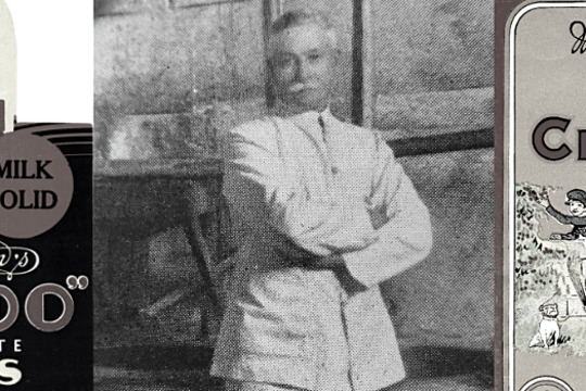
MacRobertson's Confectionery Factory
... the Shrine of Remembrance, building the MacRobertson Bridge over the Yarra River and the construction of a new building for the National Herbarium. One of MacRobertson’s most unusual bequests was of 10,000 pounds to Mawson’s 1929 Antarctica Expedition. His ...MacRobertson Steam Confectionery Works was a confectionery company founded in 1880 by Macpherson Robertson and operated by his family in Fitzroy, Melbourne until 1967 when it was sold to Cadbury.
This story accompanies the 'Nail Can to Knighthood: the life of Sir Macpherson Robertson KBE' exhibition which took place at the Royal Historical Society of Victoria in 2015.
-
 Wind & Sky Productions
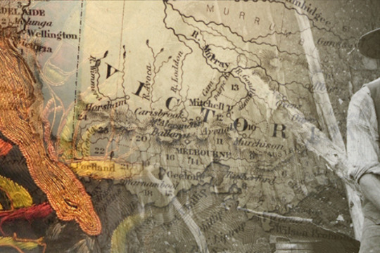
Many Roads: Stories of the Chinese on the goldfields
... Dynasty's Imperial centre hundreds of kilometres to the north. Guangzhou (Canton) itself was only a short river journey from the Portuguese sea port of Macau and Britain's new island sea port of Hong Kong, established in 1842 as a prize ...In the 1850s tens of thousands of Chinese people flocked to Victoria, joining people from nations around the world who came here chasing the lure of gold.
Fleeing violence, famine and poverty in their homeland Chinese goldseekers sought fortune for their families in the place they called ‘New Gold Mountain’. Chinese gold miners were discriminated against and often shunned by Europeans. Despite this they carved out lives in this strange new land.
The Chinese took many roads to the goldfields. They left markers, gardens, wells and place names, some which still remain in the landscape today. After a punitive tax was laid on ships to Victoria carrying Chinese passengers, ship captains dropped their passengers off in far away ports, leaving Chinese voyagers to walk the long way hundreds of kilometres overland to the goldfields. After 1857 the sea port of Robe in South Australia became the most popular landing point. It’s estimated 17,000 Chinese, mostly men, predominantly from Southern China, walked to Victoria from Robe following over 400kms of tracks.
At the peak migration point of the late 1850s the Chinese made up one in five of the male population in fabled gold mining towns of Victoria such as Ballarat, Bendigo, Castlemaine, Beechworth and Ararat. It was not just miners who took the perilous journey. Doctors, gardeners, artisans and business people voyaged here and contributed to Victoria’s economy, health and cultural life. As the nineteenth century wore on and successful miners and entrepreneurs returned home, the Chinese Victorian population dwindled. However some chose to settle here and Chinese culture, family life, ceremony and work ethic became a distinctive feature of many regional Victorian towns well into the twentieth century.
By the later twentieth century many of the Chinese relics, landscapes and legacy of the goldrush era were hidden or forgotten. Today we are beginning to unearth and celebrate the extent of the Chinese influence in the making of Victoria, which reaches farther back than many have realised.
-
 Brian Allison
John Harry Grainger
... River in association with surveyor and architect, J.S. Jenkins. Jenkins was Grainger’s partner, but the design is considered to be Grainger’s. Grainger and his wife Rose moved to Melbourne where he completed the finished drawings and hoped to oversee ...Architect and Civil Engineer
John Harry Grainger was a creative figure, largely overlooked by history. He receives a brief mention in the much-examined life story of his famous son, the composer and pianist Percy Grainger, where he is depicted as a proud but ineffectual father.
Grainger's prolific output as an architect and his extraordinary talents for bridge building have not yet received due recognition.
The material presented here is sourced from the Grainger Museum Collection at the University of Melbourne. Additional material is held in the Public Record Office of Victoria and in the State Library of Victoria collections.