-
 Ringwood and District Historical Society
Legal record - Conditions of Sale (C.E.Carter), Ringwood - Crown Portion 10, Eric Francis Seymour Staker to Stanley B Harris
Particulars and Conditions of Sale - Staker to Harris dated 10th October 1927 -
 Melbourne Tram Museum
Negative, Ellis Collection, 1940
Negative (120) of a cable tram grip car and saloon car northbound in Nicholson St between Victoria Parade and Gertrude St. Has the Salisbury Place (34 Nicholson St) block in the view. Photo 1940 based on the date that other photos were taken in the area - See Reg Item 3593. Hi Res image filed in the dbtext/hawthtramcoll/Large Images/htd3593large.jpgtrams, tramways, cable trams, nicholson st, cable trams -
![Letter from L. Bagley to [John] Williams, dated 16 January 1924](/media/collectors/56f368632162f118acbff12e/items/60d923316e5f99545134e8e3/item-media/614129c8eb4a115f1bcdae79/item-fit-380x285.jpg) Whitehorse Historical Society Inc.
Whitehorse Historical Society Inc.Legal record - Correspondence, Williams' Road Bridge, 16/01/1924 12:00:00 AM
Letter from L. Bagley to [John] Williams, dated 16 January 1924Photocopy of letter from L. Bagley to [John] Williams, dated 16 January 1924 regarding bridging a creek in order to form Williams Road.Letter from L. Bagley to [John] Williams, dated 16 January 1924 bagley, l, williams, john, williams road, blackburn, land subdivision -
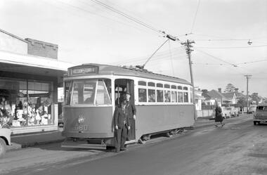
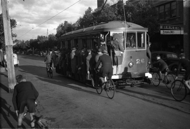 Melbourne Tram Museum
Negative, Wal Jack, 12/03/1946 12:00:00 AM
Black and white negative, of Victorian Railways tram 26 in Bay Road near depot junction - extremely overload with hangers on, footboards used and a young cyclist hanging onto the rear of the tram. Wal's album print "VR Sandringham - Black Rock Tramways - No. 26 "Toastrack" in Bay Road near depot junction - Black Rock Bound (5.55pm) 12-3-46" along with Wal Jack stamp and T555 Note the white bumper bars. A uniformed tramway man? and conductor are observing. In the background is the Roxy Theatre and the spire of the All Souls Anglican Church. (The church spire has since been rebuilt).Also in the background is the Salvation Army Hall, Barker Upholster and two buses. Photo in the Wal Jack Victorian Railways Album.trams, tramways, victorian railways, vr trams, bay road, sandringham, tram 26 -
Stawell Historical Society Inc
Map, R.O. Robson - Authorised Surveyor, Road from Glenorchy to near Geary's Selection Callawaddy 1880, 29.04.1880
Survey for Road CreationCloth Backed Map. Plan of Road.Parishes of Richella & Callawadda. County of Borong. Plan of Road. R.O. Robson Authorised Surveyor Stawell 29.04.80 -
 Eltham District Historical Society Inc
Negative - Photograph, Eltham Shire Council, Unidentified road, Eltham district, c.1985
One of a series of images on roll of film shot by Eltham Shire Council officers focussing on road and street infrastructure maintenance and upgrades and new rollover kerb and channel profilesRoll of 35mm colour negative film, 5 stripsKodak CP100 5094infrastructure, road construction, road drainage, road sealing, roadworks, shire of eltham, streets, streetscape -
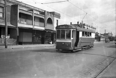 Melbourne Tram Museum
Negative, Wal Jack, c1944
Black and white negative, by Wal Jack, of S 169 in Buckley St Footscray. The building with the curved window (No. 97) remains in position near the intersection with Admiral St. The tram has the destination of Ballarat Road. Photo not dated in the Wal Jack album.trams, tramways, footscray, s class, buckley st, tram 169 -
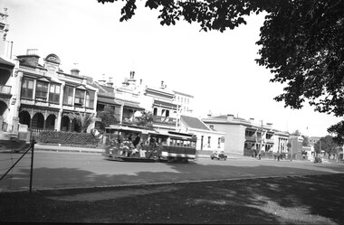
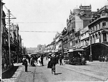 Melbourne Tram Museum
Negative, c1906
Copy negative of a photograph of cable cars in Bourke St at Swanston St with the Royal Mail Hotel in the background. Numerous cyclists and pedestrians. c1906.trams, tramways, cable trams, swanston st, bourke st -
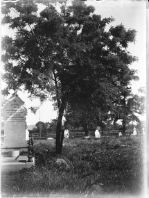 Wodonga & District Historical Society Inc
Negative - Haeusler Glass Negatives Collection - Grave of Henry Edward and Anna Emilie Klinge, c1910
The Wodonga Historical Society Haeusler Collection provides invaluable insight into life in late nineteenth and early twentieth century north east Victoria. The collection comprises manuscripts, personal artefacts used by the Haeusler family on their farm in Wodonga, and a set of glass negatives which offer a unique visual snapshot of the domestic and social lives of the Haeusler family and local Wodonga community. The Haeusler family migrated from Prussia (Germany) to South Australia in the 1840s and 1850s, before purchasing 100 acres of Crown Land made available under the Victorian Lands Act 1862 (also known as ‘Duffy’s Land Act’) in 1866 in what is now Wodonga West. The Haeusler family were one of several German families to migrate from South Australia to Wodonga in the 1860s. This digital image was produced from one of the glass negatves that form part of the collection, probably taken by Louis Haeusler (b.1887) with the photographic equipment in the Wodonga Historical Society Haeusler Collection. This item is unique and has well documented provenance and a known owner. It forms part of a significant and representative historical collection which reflects the local history of Wodonga. It contributes to our understanding of domestic and family life in early twentieth century Wodonga, as well as providing interpretative capacity for themes including local history and social history.Digital image from the Haeusler Glass negative collection. These graves can be found in the Wodonga Cemetery. Henry (Heinrich) Edward and Anna Emilie were children of Johann Wilhelm Klinge (1832 – 1907) who married Christiana Mattiske (1838 – 1918) and who are also buried in the Wodonga cemetery."IN /MEMORY/ of /HENRY EDWARD KLINGE/ WHO DIED 27TH JULY 1900/ AGED 29 YEARS./ALSO HIS SISTER/ ANNA EMILIE KLINGE/ WHO DIED 25TH JANUARY 1868/ AGED 1 YEAR AND 8 MONTHS."haeusler family graves, photography, wodonga pioneers, haeusler family, german immigration wodonga, glass negatives -
Stawell Historical Society Inc
Map, The Township of Elmhurst, Parish of Glenpatrick, Wimmera District
The Township of Elmhurst, Parish of Glenpatrick, Wimmera Districtstawell -
Canterbury History Group
Map - Maling Road Urban Renewal Map 1972, 1972
Photocopy of map of proposed urban renewal in Maling Road Canterbury 1971canterbury, maling road, town planning, maps -
 Bendigo Historical Society Inc.
Legal record - Register of Special Land Sales Castlemaine, 28/06/2007
Light brown suede leather cover with ornate embossed edging; and label on spines stating "3 and Register of Special Land Sales". Land sales between 7/03/1862 to 20/04/1869, Castlemaine District on spine. Fine black handwritten entries. First page notes Report of a Sale on the 7th March 1862, in terms of Gazette notice of 7th July 1862. Sale conducted by Public Auction by Thomas Couchman Esq. Acting D.S.land sales, castlemaine, 1860s -
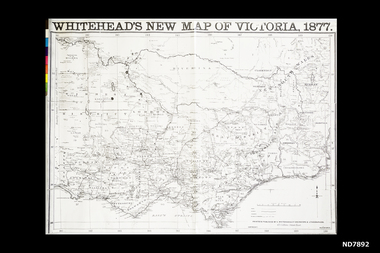 Whitehorse Historical Society Inc.
Map, Whitehead's New map of Victoria, 1877
A map of Victoria produced in 1877non-fictionA map of Victoria produced in 1877map, victoria -
Ringwood and District Historical Society
Legal record - Conditions of Sale (C.E.Carter), Mitcham, Lot 4 on Plan of Subdivision (?), Mr C.A.Lancaster to (?), 1937
Particulars and Conditions of Sale of Property , from Mr C.A.Lancaster to (?). -
Bendigo Historical Society Inc.
Map - SUTTON GRANGE : COUNTY OF BENDIGO, 21-7-22
Map. Sutton Grange, County of Bendigo, County of Talbot, Mandurang, Sedgwick, Ravenswood, Hawkestone, Harcourt, Faraday. Myrtle Creek. Victorian Water Supply - Main Line of Aquaduct from Malmsbury to Sandhurst. By authority A.J. Mullett, Government Printer, Melbourne. Photo-Lithographed at the Department of Lands and Survey, Melbourne by W.J. Butson, 21-7-22. Price 1/-. (number 125 in map cupboard 1)A.J. Mullett, Government Printer, Melbourne.map, bendigo, sutton grange -
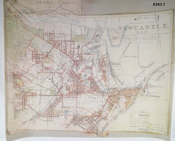 Bendigo Military Museum
Map - Map of Newcastle NSW 4 Inch - 1 Mile 1910, Australian Intelligence Corps, Nov 1910
In 1909 the Australian Army Headquarters realized that mapping in Australia was either non existent or inadequate for Military use. It was requested that Australia borrow Survey personnel from the UK Royal Engineers (RE) for a two-year detachment. On 11 April 1910 four RE NCOs arrived in Melbourne comprising CPL J Lynch, and LCPLs AH Barrett, EF Davies and R Wilcox. LCPL Barrett had 12yrs experience with RE. They were aiming at producing eight map sheets per year covering about 7,000 square miles (18,000 square Km) This map sheet of the Newcastle area was produced using plane table methods and was surveyed and hand drawn by LCPL A Barrett Oct - Nov 2010. It was unique because it was now produced on an accurate gridded base and included contouring. Lynch and Davies transferred to the Royal Australian Engineers (RAE) whilst Barrett and Wilcox returned to the UK in June 1913. Barrett returned to Australia in 1915 and also enlisted in the RAE and served until 1919.A gridded Map of Newcastle NSW area scale four inches to one mile with 25 feet interval contouring. Coloured hand drawn map produced in 1910. Signed by " A Barrett LCPL Royal Engineers"royal australian survey corps, rasvy, fortuna, army svy regt, army survey regiment -
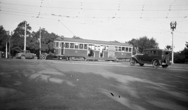 Melbourne Tram Museum
Negative, Wal Jack collection, c1930
Black and white negative from Wal Jack collection of W2 255 or 355 in St Kilda Road Melbourne at junction with City Road, with route number 7 showing. Photo c1930. Photo may not be by Wal Jack as a size that he did not use.trams, tramways, st kilda road, city road, route 7, w2 class, tram 255?, tram 355? -
University of Melbourne, Burnley Campus Archives
Map - Topographic Survey, Ararat, 1970
Australia 1:100,000 Topographic Survey map of Ararat district, Victoria dated 1970. Sheet 7423 (Edition 1) Series R 652. Produced by the Royal Australian Survey Corps.ararat, royal australian survey corps -
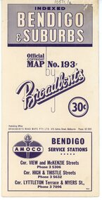 Bendigo Historical Society Inc.
Map - Three Road Maps of Bendigo, 1962
George Robert Broadbent (1863-1947), cyclist and map publisher, was born on 3 November 1863 at Ashby near Geelong, Victoria, son of George Adam Broadbent, Lancashire-born draper, and his wife Elizabeth, née Ruffhead. When the family moved to North Melbourne Broadbent attended the Errol Street school, followed his father's trade, and became an early cycling and cycle-racing enthusiast. At various times Broadbent held most Victorian and Australian road records, and two of his performances on solid tyres—203 miles (327 km) in 24 hours on a penny farthing, and 100 miles (161 km) in 6 hours 20 minutes on a 'safety' bicycle—were never bettered. He established records for all distances between 130 and 220 miles (209 and 354 km), and for all times between 8 and 12 hours, at the Exhibition Grounds track in May 1894, and road records for 50 and 100 miles (80 and 161 km) in October 1896. The Australian Cyclist acknowledged him 'the finest road rider that Australia has ever produced'. A foundation councillor of the League of Victorian Wheelmen in October 1893, Broadbent contested the first Warrnambool-Melbourne race in 1895, and was active in the Good Roads Movement. Next year he issued a road map of Victoria, 'prepared … after some sixteen years riding and touring in all parts of the Colony', which indicated general topography, distances, and roads classified as 'good', 'fair' or 'ridden with difficulty'. It was to become Victoria's standard map, and the basis of a continuous publishing programme by Broadbent's Official Road Guides Co.Three Road Maps of Bendigo, Bendigo and Suburbs, Bendigo and Eaglehawk. Two fold out maps printed in colour and produced by Broadbent's Road Maps Pty. Ltd. 475 Collins Street Melbourne. One map printed by Bolton's Bendigo.history, bolton's, bendio broadbent maps -
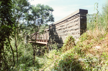 Eltham District Historical Society Inc
Negative - Photograph, Old Lower Plenty Bridge, c.Mar. 1983
Roll of 35mm colour negative film, 4 stripsKodak Safety 5035lower plenty bridge -
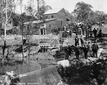 Eltham District Historical Society Inc
Negative - Photograph, Opening of St. Andrews Battery, Queenstown, 29 Aug. 1919
Reproduced on p31 of 'Pioneers & Painters' Was destroyed in 1962 bushfire. Now Peter Franks Reserve, St Andrews On Friday 29th (August 1919) …, the Hon. S. Barnes, M. L. A., Minister of Mines, accompanied by Mr W. Everard, M.L.A., Mr. V. Dickson, secretary for Mines, and Mr. Merrin, Chief Mining Inspector, visited Smith's Gully for the purpose of opening, the new Government battery which has recently been erected. The party arrived punctually at 12.30, and was received by an assemblage of about 200 residents, including, those representing local prospecting and mining interests. At the mill house the Minister wished prosperity to mining on the old Queenstown field, and, in a few appropriate remarks, gave the battery the name of St. Andrew's. Then, as the stamps began to fall, three hearty cheers were given by the gathering. ….. The Queenstown field, dating back to the early sixties, might be regarded as a link that took them back to the Augustine age of gold mining in Victoria…From 1868 to 1918 the total yield of gold from the field was 274,606 fine oz. It might be that here, as elsewhere, deeper prospecting would give new life to the Queenstown goldfield. The miners of Queenstown, who through long year's had never lost faith in the possibilities of the field, felt that the purpose for which they were that day marked the beginning of a new era in the history of local reefing. …. The new mill is situated on the bank of the creek opposite the Queenstown Cemetery, and consists of a five head battery (Berdan pan) and 12 h.p. portable steam engine housed in a spacious structure of wood and iron. A concrete weir across the creek provides a good water supply, and all the necessary pumps, settling dams, etc., have been installed. Later on, should circumstances warrant it, it is pro-posed to erect Wilfley tables for concentrates. Eltham and Whittlesea Shires Advertiser and Diamond Creek Valley Advocate, Friday 5 September 1919, page 3This photo forms part of a collection of photographs gathered by the Shire of Eltham for their centenary project book,"Pioneers and Painters: 100 years of the Shire of Eltham" by Alan Marshall (1971). The collection of over 500 images is held in partnership between Eltham District Historical Society and Yarra Plenty Regional Library (Eltham Library) and is now formally known as the 'The Shire of Eltham Pioneers Photograph Collection.' It is significant in being the first community sourced collection representing the places and people of the Shire's first one hundred years.Digital image 4 x 5 inch B&W Neg Print 20 x 25 (2)shire of eltham pioneers photograph collection, queenstown, st andrews, st. andrews battery, gold mining, s. barnes, merrin, st andrews battery, v. dickson, william h. everard, peter franks reserve -
Ballarat Tramway Museum
Legal record - Legal Document, Ballarat Tramway Preservation Society(BTPS) and Shane McCarthy, Constitution of Ballarat Tramway Preservation Society, 1971
26 page, single sided stencil ink duplicated document of the Ballarat Tramway Preservation Society Constitution, with two and half pages of forms or schedules. This document was based on the Australian Railway Historical Society Vic. Div. and largely prepared by Shane McCarthy. Note reference to Ballarat Resident members and Councillors Was the basis of the Articles of Association of the BTPS Ltd. prepared during 1973. Understood to be prepared during 1971. Stapled in top left hand corner, with two punch holes on left hand edge."Shane McCarthy" in pencil on top right hand side in what appears to be George Netherway's hand writing.trams, tramways, btps constitution, btps, constitution -
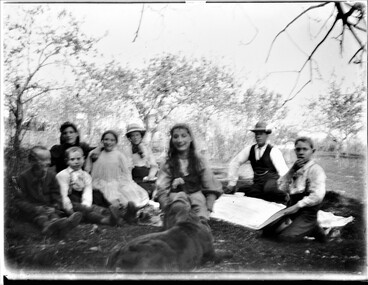 Wodonga & District Historical Society Inc
Negative - Haeusler Glass Negatives Collection - Family picnic, c1910
The Wodonga Historical Society Haeusler Collection provides invaluable insight into life in late nineteenth and early twentieth century north east Victoria. The collection comprises manuscripts, personal artefacts used by the Haeusler family on their farm in Wodonga, and a set of glass negatives which offer a unique visual snapshot of the domestic and social lives of the Haeusler family and local Wodonga community. The Haeusler family migrated from Prussia (Germany) to South Australia in the 1840s and 1850s, before purchasing 100 acres of Crown Land made available under the Victorian Lands Act 1862 (also known as ‘Duffy’s Land Act’) in 1866 in what is now Wodonga West. The Haeusler family were one of several German families to migrate from South Australia to Wodonga in the 1860s. This digital image was produced from one of the glass negatives that form part of the collection, probably taken by Louis Haeusler (b.1887) with the photographic equipment in the Wodonga Historical Society Haeusler Collection.This item is unique and has well documented provenance and a known owner. It forms part of a significant and representative historical collection which reflects the local history of Wodonga. It contributes to our understanding of domestic and family life in early twentieth century Wodonga, as well as providing interpretative capacity for themes including local history and social history.Digital image created from the Haeusler Glass negative collection. A family group sitting outside having a picnic. There are trees in the background.wodonga pioneers, haeusler family, glass negatives, dry plate photography, wodonga families, picnic -
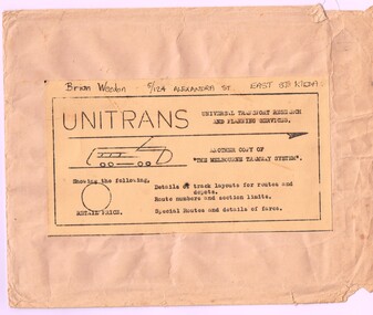 Melbourne Tram Museum
Map, Russell J. Nowell, "The Melbourne Tramway System", mid 1960's
Printed map (dye line process) on a large sheet of paper contained within an envelope. .1 - Brown paper envelope with a printed sheet glued to the envelope - giving title "The Melbourne Tramway System", publisher ("Unitrans - Universal Transport Research and Planning Services" - with a space for the retail price. .2 - Map printed on paper and folded into 16 parts - details the track layouts for routes and depot, route numbers, sections, Latrobe and William St services and details of fares. Has a sketch of tram 980 in the top right hand corner along with details of the tram system. Also includes depot locations, reserved tracks and derails at level crossings, though railway level crossings are not shown. Produced by Russell J. Nowell - gives address and phone number along with the "UniTrans" logo. Advised by other members, he was a Tasmanian. Not dated, but appears to be mid 1960's. Plan scanned 1-3-2016 as a tiff file.Envelope has the name and address of the donor "Brian Weedon 5/124 Alexandra St East St Kilda"trams, tramways, map, mmtb, depots, tram routes, trackwork -
Ballarat Tramway Museum
Map, Ministry of Transport, "Metropolitan Transport Services Map - Melbourne - Tram and Bus Services", c1970
Pocket size - folded - public transport map of Melbourne, printed in colours showing the bus, train and tram routes around Melbourne. Has a cover price of 10c. No printing date shown, but c1970 as distances are still in imperial, the West gate bridge is shown, though so is the Williamstown Ferry. Gives telephone numbers in 6 digit figures. Lists route numbers for trams, tramways board bus services and private services. Gives various telephone numbers for further information. Notes the map is a combined effort of the Tramways Board, Victorian Railways, Bus Proprietors' Association and the Transport Regulation Board. Single sheet of paper folded in 9 x 3 folds.trams, tramways, melbourne, map, public transport, routes -
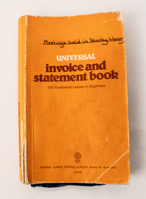 Stanley Athenaeum & Public Room
Legal record - Invoice & Statement Book, Invoice & Statement Book 1997-1998
Olympic Invoice & Statement Book for Stanley Library Accounts 1997-1998. Orange cover with black binding. Copymate, carbonless. 50 leaf, duplicate, No724. Handwritten title ' Stanley Library Accounts' Library. Printer Olympic. -
 Melbourne Tram Museum
Negative, Travis Jeffery, c1963
B&W negative of tram 680 in Barkly St, Russell St, West Footscray Tram has destination Williamstown Rd. Driver and conductor posing for camera on front steps of tram.Paper folder that contained the negative had "NR102A" written in red ink, "F16" in pencil, "61A" in green ink and dated stamped as 1 Jan 1963.trams, tramways, x2 class, footscray, barkly st, williamstown rd, crews, drivers, conductors, russell st, tram 680 -
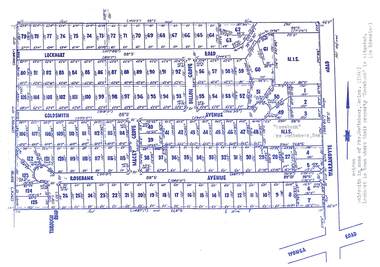 Ringwood and District Historical Society
Map, Subdivision Plan - Rosebank Avenue area, North Ringwood, Vic. - circa 1960s
Single page plan printed on green background showing allotments included in un-named subdivision layout surrounding "Rosebank" property, Warrandyte Road, Ringwood North. Subdivision includes Through Road, Rosebank Avenue, Macey Grove, Goldsmith Avenue, Dillon Grove, Lockhart Road, and Warrandyte Road.Typewritten notation against "Rosebank" property - "Mrs Godbehear, Snr.". "Goldsmith is maiden name of Mrs. Godbehear, Senior. (1960). Lockhart is town where their property "Rosebank" is situated. (In Riverina)". -
Stawell Historical Society Inc
Map, Agricultural Area of Lake Wilson, Parishes of Bellaura & Bellellen, 1865
Agricultural Area of Lake Wilson, Parishes of Bellaura & Bellellenstawell -
Ringwood and District Historical Society
Legal record - Conditions of Sale (C.E.Carter), Ringwood , Lot 5 on Plan of Subdivision 9648, Mr A.H.Loche to Mr C.F.Osmond, 1944
Particulars and Conditions of Sale of Property , from Mr A.H.Loche to Mr C.F.Osmond.