-
 Whitehorse Historical Society Inc.
Map, Station Street Mitcham
Map of business premises in Station Street Mitcham c. 1940s, drawn by Veronica Stodgell.Map of business premises in Station Street Mitcham c. 1940s, drawn by Veronica Stodgell. Photos of beauty salon manageress Joyce Phillips and Veronica StodgellMap of business premises in Station Street Mitcham c. 1940s, drawn by Veronica Stodgell. station street mitcham, no.9, phillips, joyce -
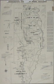 Federation University Historical Collection
Plan, Underground Survey of Mines, Ballarat, 1887
Printed plan with text down right side and black border, 4 holes top edge and repairsplan, underground survey, robert allen, w. langtree, prince of wales and bonshaw united, bonshaw, south plateau, north plateau, sebastopol plateau, sebastopol star, star of the east, south star, band and albion, owen's freehold, leigh river, yarrowee creek, robert allan, gay's freehold -
National Vietnam Veterans Museum (NVVM)
Journal, Baria Bugle
veterans – australia – periodicals, vvaa – bendigo sub-branch -
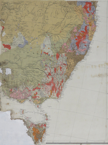 Federation University Historical Collection
Map, South East Australia, not dated
Printed colour maptasmania, new south wales, victoria -
 Federation University Historical Collection
Plan, Ballarat Railway Plan, 1888, 27/02/1888
.1) Copy of a Ballarat Railway Plan, running along Belford Street, from the Engineer in Chief's Office, Railway Department. It shows bridges, diversions, culverts and the following streets: Joseph Street, Lal Lal Street, Clayton Street, Belford Street, Rodier Street, trench Street, Stawell Street, Rodier Street, Belford Street, George Street, Eureka Street, Queen Street, Otway Street, Scott Parade, Ross Street, Chamberlain Street, Victoria Street, Water Street. Allotments owned by Tulloch and McLaren, J. Wilson, J. McCarthy, Mrs P. Glynn, E. Ratcliffe, soap works, Orphan Asylum .2) Copy of a plan relating to the construction of the Ballarat Railway Line. It includes shafts for the following companies: South Extended Co, Black Hill; Parade Co.; Black Hill Co.; Spanhake Co. Shaft; Black Hill South Co.; Wellingtonia Gigantiea Co., and the old workings of the Welllingtonia Gigantea Co,ballarat railway plan, belford street, lal lal street, clayton street, rodier street, trench street, south extended co., black hill, parade co., spanhake co. shaft, black hill south co., wellingtonia gigantiea co, railway -
 Kew Historical Society Inc
Plan - Subdivision Plan, Houghton Street & Buchanan Avenue, Balwyn North, ca. 1906
The Kew Historical Society collection includes almost 100 subdivision plans pertaining to suburbs of the City of Melbourne. Most of these are of Kew, Kew East or Studley Park, although a smaller number are plans of Camberwell, Deepdene, Balwyn and Hawthorn. It is believed that the majority of the plans were gifted to the Society by persons connected with the real estate firm - J. R. Mathers and McMillan, 136 Cotham Road, Kew. The Plans in the collection are rarely in pristine form, being working plans on which the agent would write notes and record lots sold and the prices of these. The subdivision plans are historically significant examples of the growth of urban Melbourne from the beginning of the 20th Century up until the 1980s. A number of the plans are double-sided and often include a photograph on the reverse. A number of the latter are by noted photographers such as J.E. Barnes.A hand-drawn subdivision plan listing six blocks bounded by Houghton Street, Doncaster Road, Buchanan Avenue and Maud Street, North Balwyn. Written on the plan of subdivision are the lot numbers, the dimensions of the blocks and the price at which two lots were for sale or had been sold for.subdivision plans - balwyn -
Kew Historical Society Inc
Journal, Kewriosity : December 1983
Action taken on security of children [Safety House Programme] / p1. Youth venue needed / p1. Extraordinary election - Central Ward / p1. Poodle guides [Guide dogs] / p2. New Welfare Officer [Jennene Arnel] / p2. Uniting Church Normanby Road 'Play Group' or Pre Kinder Support Group / p2. The Rotary Club of Kew / p3. Probus Club [of Kew] / p3. Holiday Programme Activities / p4. Where and what is "Bodalla"? [aged care] / p4. Lisa's school day [Glendonald] / p5. Give a piece of our past this Christmas [Illustrations, Kew Historical Society] / p5. Know your local school [Kew High School] / p6. Coming events / p7. Carols by Candlelight / p8.Kewriosity was a local newsletter combining Kew Council and community news. It was published between November 1983 and June 1994, replacing an earlier Kewriosity [broad] Sheet (1979-84). In producing Kewriosity, Council aimed to provide a range of interesting and informative articles covering its deliberations and decision making, together with items of general interest and importance to the Kew community and information not generally available through daily media outlets.non-fictionAction taken on security of children [Safety House Programme] / p1. Youth venue needed / p1. Extraordinary election - Central Ward / p1. Poodle guides [Guide dogs] / p2. New Welfare Officer [Jennene Arnel] / p2. Uniting Church Normanby Road 'Play Group' or Pre Kinder Support Group / p2. The Rotary Club of Kew / p3. Probus Club [of Kew] / p3. Holiday Programme Activities / p4. Where and what is "Bodalla"? [aged care] / p4. Lisa's school day [Glendonald] / p5. Give a piece of our past this Christmas [Illustrations, Kew Historical Society] / p5. Know your local school [Kew High School] / p6. Coming events / p7. Carols by Candlelight / p8. publications -- city of kew (vic.), kewriosity, council newsletters, community newsletters -
Glen Eira Historical Society
Plan - Nettalie
An A4 photocopy of the 'Plan of the Caulfield Road District' dated 1867. This plan shows the location of the properties owned by A Shaw and Blundell on Balaclava and Orrong Roads where Nettalie is situated. The plan includes all the landowners listed where their property was, the street names and other landmarks of 1867 including railways, hotels and reserves.caulfield, caulfield north, elsternwick, st kilda east, parish of prahran, parish of moorabbin, caulfield road district, melbourne and brighton railway, rosstown railway, elsternwick railway station, caulfield railway station, rosstown railway station, murrumbeena railway station, baptist church, paddy’s swamp reserve, cemetery reserve, leman swamp reserve, caulfield racecourse reserve, brighton cemetery, the vine caulfield hotel, the tam o’shanter hotel, melbourne hunt hotel, royal hotel, hotham street, horne street, nepean highway, north road, orrong road, dandenong road, princes highway, kooyong road, alma road, inkerman road, balaclava road, glen eira road, glen huntly road, hawthorn road, cemetery road, bambra road, redan road, kambrook road, neerim road, booran road, racecourse road, grange road, koornang road, murrumbeena road, crosbie road, kangaroo road, poath road, ford w, lempriere, cople j, riddell j c, manifold j, testar t, billing r h, semple, blundell, shaw a, butchart g, stephen j w, stephen g sir, hart j, duncan g, blackie r, stephen f, mccombie t, woollaston h, higgins j, lloyd j c, daish j, mcleod j, hughes d, wilson a, jamieson g, webb g h, renwick s, pennington h, dunn j, kirkpatrick w, ricketson w, toad a, sayce j, watts t, widgery, store, guess j, anketell j, clack j, sissen w, clayton g, dickson d, bevan j, hart t, anderson j, hart mrs, webb h, masters s, waghorn j, hemming c, hiam c, farquhar w, newing t, payne t, cooper r, snipe s, chambers j, forster w, summers r, harriman b, warrick, o’connell, long j, peck r, cochrane c, murray ross w, evans c, kennedy j, maclean n, forster, lyall w, dean j, newton h, looker w, baker c, johnston, crosbie j, kerr, jones, parr, nelson c, montgomery l, parsons w, james j c, sibon c, smith sydney w, plans, maps, land subdivisions, land use, settlements, roads and streets, hotels, churches, police stations, post offices, land surveys, railway stations, railways, schoolhouses, commerce, clergy residences, official buildings, local government, road districts -
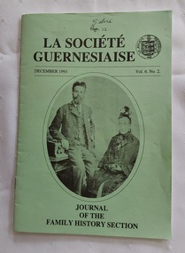 Mont De Lancey
Journal, La Socie'te' Guernesiaise, December 1993
The family history section of this association lists - 1. The Objects of the Section are to - 1.1. Promote, foster and encourage research into family history and 1.2. Collate, preserve and catalogue resource material and make it available to members and 1.3. Liaise with such persons or bodies as may be conducive to these objects. The Mont De Lancey features in this editionA pale green thin 'Journal of the Family History Section: La Socie'te' Guernesiaise' in booklet format. The front cover has the title printed in black lettering at the top with an oval shape depicting a man and woman sitting for a portrait inside it. The volume and date of publication is also printed. The round emblem of La Socie'te' Guernesiaise 1882 is printed on the front top right corner. 24p.non-fictionThe family history section of this association lists - 1. The Objects of the Section are to - 1.1. Promote, foster and encourage research into family history and 1.2. Collate, preserve and catalogue resource material and make it available to members and 1.3. Liaise with such persons or bodies as may be conducive to these objects. The Mont De Lancey features in this editiondocuments, journals, family history, sebire family, mont de lancey house, mont de lancey museum -
 Greensborough Historical Society
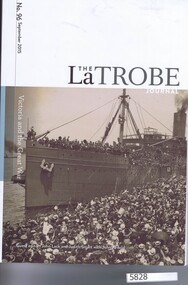
Journal, State Library of Victoria, Victoria and the Great War: Special issue of the La Trobe Journal No. 96 September 2015, 2015_09
Contributions on the history of World War 1 on previously unresearched areas, most relevant to Melbourne and Victoria.Paperback. 224 p., black and white and colour illustrationsworld war 1 -
 Buninyong Visitor Information Centre
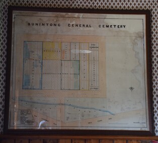
Plan - Cemetery Plan, Buninyong General Cemetery
Plan of the complete layout of the Buninyong General Cemetery drawn by Robert [surname unclear] on 6 April 1871.Framed and glazed original large hand drawn plan of the Buninyong General Cemetery, showing the locations of denominational sections and plots. Buninyong General Cemeterycemeteries, historic sites, buninyong -
Port Melbourne Historical & Preservation Society
Plan - Sandridge, Department of Lands and Survey, "The Township of Sandridge", 5 Nov 1860
Map of Sandridge, lithographed 1860, showing subdivisions on Evans Street, but no other development West of the railway Lihographed at the Department of lands and Survey, Melbourne 5th November 1860. Hand drawn annotations added at unknown date.Hand written "clay ground" 18 chains long, 7.5 chains broad, 26 chains from railwayengineering - roads streets lanes and footpaths, sandridge lagoon, transport - railways, town planning, local government - borough of sandridge -
 Whitehorse Historical Society Inc.
Map - Nunawading scaled Map, Nunawading, 1864
Parish plan of Nunawading, Lands Department, 1864, showing names of first purchasers of land. Copy also at NP215.parish of nunawading, land settlement, maps -
University of Melbourne, Burnley Campus Archives
Plan, Burnley Gardens Site Works, 1961
Coloured plan by Public Works Department, Chief Engineers Branch. Burnley Gardens, Site Works No 61.263. Drawn and traced by W. ? Walker Engineer, dated 30.05.1961.burnley gardens -
Moorabbin Air Museum
Journal (Item) - Reach Out We Make The Difference Ansett Australia
-
 Falls Creek Historical Society
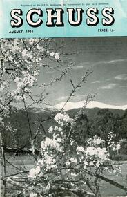
Journal - Schuss Vol. 21. No. 6 August 1955
Schuss was advertised as Victoria’s Official Ski Journal It was issued monthly from 1935 to 1961 except during the war when summer issues covered two months. This continued after the war, but it averaged 10 issues annually over its 25 year life. Schuss was published by the Ski Club of Victoria which had a membership of 38 Ski Clubs and demanded to be recognised as the prime authority on skiing in the state. The other 30 ski clubs with 85% of the members disagreed and the politics of skiing became heated. These clubs formed the Federation of Victorian Ski Clubs with their own journal, Ski Horizon. With the establishment of the Victorian Ski Association, Ski-Horizon published its last issue in Nov - Dec. 1955 and the role of the official journal was fully taken over by “Schuss”. This item is significant because it contains stories, images and information documenting the development of the ski industry in Victoria.The journal features stories and events chronicling developments in Victoria and internationally. Items related to the Falls Creek Area in this issue include:- Page 196 - A report on the Victorian Championships held at Falls Creek on 14 August 1955. Page 201 - SKYLINE Lodge of Falls Creek carried about eight feet of snow on its roof after the big August fall. As this consolidated more was added, till there was some 15 to 20 tons of packed snow on the roof. It also caused some damage which will require repairs in the spring; assistance from members is required in this work. This unusual depth of snow ensures skiing on the slopes above Skyline till well into the summer months. schuss journal, victorian championships 1955, skyline lodge -
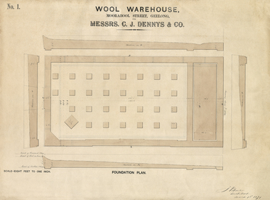 National Wool Museum
Plan - Architectural Plan, Wool Warehouse, Moorabool St, Geelong for Messrs C.J. Dennys & Co., Foundation Plan No. 1
Original Jacob Pitman architectural plan of the Dennys Lascelles bluestone woolstore dated 1 March 1871. Titled "Wool Warehouse, Moorabool St, Geelong for Messrs C.J. Dennys & Co., Foundation Plan No. 1".Wool Warehouse, Moorabool St, Geelong for Messrs C.J. Dennys & Co., Foundation Plan No. 1wool stores, pitman, mr jacob, dennys lascelles wool store -
 Ballan Shire Historical Society
Map - Map. Korweinguboora, Department of Lands and Survey, Korweinguboora. Counties of Talbot and Grant
A map of the Korweinguboora area showing roads, forests, railway lines and properties with the owners names.The inclusion of the names of landowners is of significance and value to historians.A map of the Korweinguboora area showing land subdivisions and names of owners and other physical features. There is a scale in chains. No date is certain but it could be 1902. The map has been repaired with sellotape.There are various pencil annotations but the are difficult to read.talbot, moorarbool west, wombat, bullarto, korweinguboora, moorarbool east, dean, wombat state forest, barkstead -
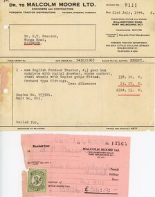 Ringwood and District Historical Society
Financial record - Invoice and receipt, Sale of Fordson tractor, July, 1944
Invoice Dr to Malcolm Moore Ltd, Engineers and Contractors, to Mr H. F. Pearson, Wonga Road, Ringwood, Victoria. Receipt with Victorian duty stamp attached - July 1944 1 new English Fordson Tractor, 4.3 gear box complete with radial drawbar,choke control, steel wheels with Duplex grips fitted. Orchard type fittings. £338.10.0 Less Allowance £13.17.0. Total amount and receipt £324.13.0. -
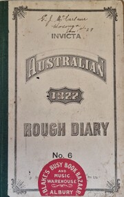 Wodonga & District Historical Society Inc
Journal - Australian Rough Diary 1927, Sands & McDougall Pty. Ltd
George James McFarlane was born on 19 August 1895 in Wodonga, Victoria. He was the youngest son of Charles John McFarlane and Emily Charlotte nee Ellis. He married Margaret Frances Kirley in Wodonga in 1918 and they had 6 children. George kept this diary for most of 1927. It documents his daily life and some local events. George worked part time with the local blacksmith and then on his own farm before and after work. He was later to take over the blacksmith himself, operating as a blacksmith and farrier from premises in High Street, Wodonga. George's diary documents his daily dedication to other jobs on the farm including trapping and shooting vermin such as rabbits and foxes, growing watermelon and vegetables and training horses. He also became a member of the Albury Coursing Club. In his later years, George moved to Euroa and then fo the Northcote and Broadmeadows area of Melbourne where he died in 1968.A small diary with cardboard cover including volume and publisher details within a border. A red and white retailer sticker has been adhered to the front cover. The diary includes a calendar for 1927 and 37 pages of information including postal, money order and telegraphic information, British weights and measures and Directions for Making a will. The remainder of the diary is divided into 3 days per page. Entries have been entered until 28 August 1927.On front Cover: INVICTA AUSTRALIAN 1927 ROUGH DIARY / No 6 WITH THREE DAYS ON A PAGE / Price 2s. /PRINTED AND PUBLISHED BY SANDS & MCDOUGALL PTY. LTD. / SOLD BY ALL STATIONERS. On a circular sticker adhered at lower edge: BLAKE'S BUSY BOOK BAZAAR/ AND MUSIC WAREHOUSE/ ALBURY Handwritten on front: G J. McFarlane/ Wodonga/ Jan 1st 27g. j. mcfarlane, mcfarlane family wodonga -
Moorabbin Air Museum
Plan (item) - Bristol Aeroplane 170 schematic drawings, Assembly of Oversize Joint Bolts Main Wing to Fuselage Bolt
Bristol Aeroplane Company -
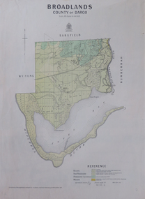 Federation University Historical Collection
Map, Broadlands, County of Dargo, 1887
Plan of Broadlands, County of Dargo, Victoria.broadford, j.g. easton, dargo, geological -
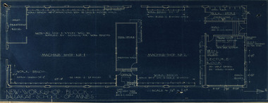 Federation University Historical Collection
Plan, New Workshop Block Ballarat School of Mines
It is not known which building these plans belong to. Since there is a Heat Treatment Room and a number of vices it may be a metalwork room, and may be related to Repatriation classes after World War One. Blueprint of plans for a new workshop at the Ballarat School of Mines. The plan includes a lecture room, bulk store, tool store, heat treatment room, office and two machine shops. Around the machine shops are work benches and vyces (sic)new workshop block, ballarat school of mines, repatriation, buildings -
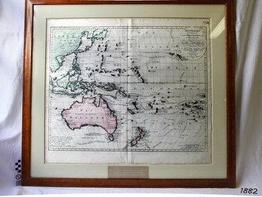 Flagstaff Hill Maritime Museum and Village
Map, Australien (Sudland) auch Polynesien oder Inselwelt, insgemein der funfte Welltheil, c.1990
This map is a reprint of Johann (Johannes) Walch’s “Australien (Sudland) auch Polynesien oder Inselwelt, insgemein der funfte Welltheil”, published in 1802. It shows Australia, New Zealand, South East Asia and the Pacific Islands shows a large number of places names, many of which have changed since the map was drawn. The map includes the routes and dates of the voyages of Tasman, Cook, Bougainville, Carteret, Byron, and others up to 1802. The shapes of the lands on this early map show that some of the areas had not yet been charted. The map was donated to Flagstaff Hill Maritime Village in April 1990 by the Group Study Exchange Team from Rotary District 233, Sweden. It was framed and presented by Rotary District 978 and presented by Barry Lange, the Governor of District 978 in 1989-90. (District 978, Geelong East, is now District 9780.) Johann (Johannes) Walch Johann Walch, painter and engraver, was born in 1757. He was well known for creating miniature portraits. He gained his training in Geneva, Venice and Rome. His publications include atlases and sheet maps, many of which were reprinted after his death in 1816. This reprint of an 1802 is significant for its historical and geographical contant, showing the voyages of many early explorers to the southern regions of the world including Australia. It also shows the early names used for countries and towns and is a valuable reference to historical interpretation. The map itself is a fine example of hand drawn and hand coloured maps of the early 19th century, the method of production, detail included, layout, symbols and so forth.Map, reprint of Johann (Johannes) Walch’s “Australien (Sudland) auch Polynesien oder Inselwelt, insgemein der funfte Welltheil “, first published by in Ausburg in 1802. The image on this Map No 5B, shows Australia and the south Pacific. The timber framed, glass covered, printed and coloured map was created in two sections and joined. Brass plaque at base of map states that the map was presented to Flagstaff Hill by Rotary International in April 1990. Feint lines used for aligning lettering can be seen on the map and there are large erased letters such as a “D” and “S” that are almost obscured.Plague “ROTARY INTERNATIONAL / THE MAP WAS DONATED BY THE GROUP STUDY EXCHANGE TEAM / FROM ROTARY DISTRICT 233 SWEDEN IN APRIL 1990 / AND WAS FRAMED AND PRESENTED BY ROTARY DISTRICT 978 / BARRY LANGE – GOVERNOR DISTRICT 978 1989/90” Stamped on back “ELLIMINOOK FRAMES / MRS. JILL FALKINER / ELLIMINOOK / BIRREGURRA, VIC. 3242 / PHONE: (052) 36 2080” flagstaff hill, warrnambool, shipwrecked coast, flagstaff hill maritime museum, maritime museum, shipwreck coast, flagstaff hill maritime village, great ocean road, australien (sudland) auch polynesien oder inselwelt, insgemein der funfte welltheil, johann (johannes) walch, cartographer johann (johannes) walch, ausburg publisher johann (johannes) walch, johann (johannes) walch map number 5b, 1802 map of australia and south pacific, rotary international group study exchange team, rotary district 233 sweden, elliminook frames, voyages of tasman, voyages of cook, voyages of bougainville, voyages of carteret, voyages of byron, barry lange, painter of miniature portraits johann (johannes) walch -
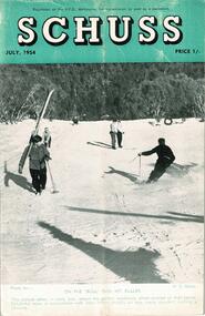 Falls Creek Historical Society
Journal - Schuss Vol. 20. No. 5 July 1954
Schuss was advertised as Victoria’s Official Ski Journal It was issued monthly from 1935 to 1961 except during the war when summer issues covered two months. This continued after the war, but it averaged 10 issues annually over its 25 year life. Schuss was published by the Ski Club of Victoria which had a membership of 38 Ski Clubs and demanded to be recognised as the prime authority on skiing in the state. The other 30 ski clubs with 85% of the members disagreed and the politics of skiing became heated. These clubs formed the Federation of Victorian Ski Clubs with their own journal, Ski Horizon. With the establishment of the Victorian Ski Association, Ski-Horizon published its last issue in Nov - Dec. 1955 and the role of the official journal was fully taken over by “Schuss”. This item is significant because it contains stories, images and information documenting the development of the ski industry in Victoria.The journal features stories and events chronicling developments in Victoria and internationally. Items related to the Falls Creek Area in this issue include:- Page 169 SKYLINE LODGE COMMENCES SEASON SKYLINE Lodge at Falls Creek had a full complement of members for the opening of the season at Queen's Birthday weekend. Snow was ample, though soft, and care had to be taken till it was ironed out. The members reported very favorably on the hot shower installed by the working party at Easter, as also on the other facilities of Skyline. Falls Creek was particularly busy with skiers as every lodge in the village seemed crammed with members of the respective clubs all rarin' to go on the slopes. With Ski-Tow, Canteen, and many other attractions, there seems every promise that once again Falls Creek will enjoy a skiing season lasting well into November with delightful spring conditions to satisfy the keenest skiers.schuss journal, the ski club of victoria, skyline lodge -
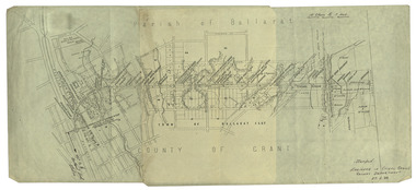
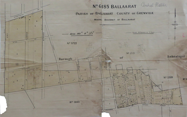 Federation University Historical Collection
Map, No 6185 Ballaarat Parish of Ballaarat County of Grenville, not dated
Printed map with pencil inscriptionsmap, parish of ballaarat, grenville county, sebastopol, central company engine house, wesleyan reserve, victoria street, yarrowee street, charlotte st, kyle street -
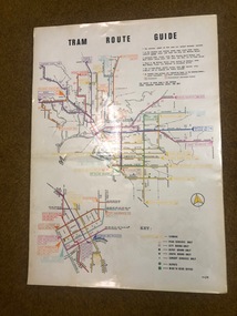 Melbourne Tram Museum
Map, Melbourne & Metropolitan Tramways Board (MMTB), "Tram Route Guide", Jun. 1982
Full colour map or poster printed on clear plastic with an adhesive peel off backing sheets, titled "Tram Route Guide". Map dated 6/82, showing routes with route numbers and names of main destinations. Has notes about the services, weekend bus replacements and telephone numbers for information. 1982 Note this version does not show the route 88 extension as similar map 1098 or 3765 does, but is a later version.trams, tramways, mmtb, map, routes, posters -
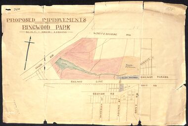 Ringwood and District Historical Society
Map, Proposed Improvements to Ringwood Park (Ringwood Lake) dated 14 January 1927
Proposed Improvements to Ringwood Park (Ringwood Lake) dated 14 January 1927, signed Cr McCaskill. Main Road is Whitehorse Road (Maroondah Highway), and Mt Dandenong Road is incorrectly labelled Whitehorse Road. The map shows Rosedale Crescent and Railway Parade, both of which exist in 2024. On the bottom of the map, south of the railway line, showing proposed streets - Graham Road, Anderson Street and Adams Street - in preparation for the sale of the Theo Anderson property. That area is now Bedford Park. -
 Falls Creek Historical Society
Journal - Ski-Horizon Vol 4 No 3, November 1952
Ski-Horizon is the official journal of the Federation of Victorian Ski Clubs which began publication in 1949. The were 26 original member clubs which included Albury Ski Club, Bogong Ski Club, Myrtleford Ski Club, Tallangatta and District Ski Club and Wangaratta Ski Club. Two pioneers of Falls Creek, Tom Mitchell, M.L.A., and Martin Romuld were Vice-Presidents of the Federation.This Journal is significant because it documents the early development of skiing in Victoria.The journal features stories and events chronicling developments in Victoria and internationally. There were no items directly related to the Falls Creek Area in this issue, but Page 12 featured an advertisement for Eastern Roadlines Pty. Ltd. bus services to Falls Creek. The inside back cover also included an advertisement for Fred Griffith's Romney Stud at Toonallock which was the regular venue for the Albury Ski Club Annual Ball.tom mitchell m.l.a., toonallook, fred griffith -
Moorabbin Air Museum
Plan (item) - Bristol Aeroplane 170 schematic drawings, Installation of Bolts -Rear Spar Top Boom
Bristol Aircraft Company Ltd