-
 Glen Eira Historical Society
Map - Kooyong Road, Caulfield North
A sepia photograph of Kooyong Road (61 x 87mm) undated and unattributed. Accompanied by an undated, unattributed handrawn map of road (42mm x 87mm) and explanatory handwritten notes detailing what is depicted in the photograph: looking towards a field and church at the intersection of Kooyong and Glen Eira Roads. Map and handwritten explanatory notes have been photocopied from the back of one sepia photograph.kooyong road, glen eira road, derby parade, brighton road, caulfield north -
Stawell Historical Society Inc
Map, 1954
Crowlands, Counties of Borung & Kara Karastawell -
Stawell Historical Society Inc
Map
Parish of Stawell, Sheet 1stawell -
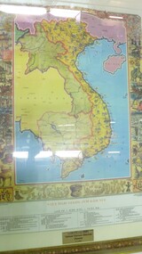 National Vietnam Veterans Museum (NVVM)
Map - Map, Vietnam
Colour map of vietnam and neighbouring countries with a decorative border of cultural aspects in a gilt framedonated by the Pham Family to National Vietnam Veterans Museum 9.03.2007map, vietnam -
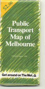 Ballarat Tramway Museum
Map, Ministry of Transport and The Met, "Public Transport Map of Melbourne" - "Effective August 1988", 1988
Map - Pocket size - folded - public transport map of Melbourne, printed in colour on art paper, showing public transport services in greater Melbourne, an index of localities. The City Saver area shown in detail. On the rear, route numbers, line maps of tram routes, train lines, outer metropolitan services, ticketing information, Transport Neighbourhoods, . Shows the St Kilda and Port Melbourne light rail lines. Price $2. Shows "The Met" logo. On front under The Met logo and above the scale bar is "Effective 1/7/1988". Niltrams, tramways, melbourne, map, routes -
Whitehorse Historical Society Inc.
Map, Map of Nunawading, 1950?
Map of the entire City of Nunawading: complimentary map issued by Frank Fisher & Co real estate agents, Blackburn.Map of the entire City of Nunawading: complimentary map issued by Frank Fisher & Co real estate agents, Blackburn.Map of the entire City of Nunawading: complimentary map issued by Frank Fisher & Co real estate agents, Blackburn.nunawading, map -
Stawell Historical Society Inc
Map, 1945
William, County of Borungstawell -
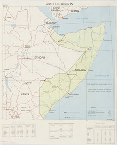 Beechworth RSL Sub-Branch
Map - Map Somalia Region, 1992
This map was used for briefing purpose only as the relief data is incomplete. Double sided coloured paper map of the Somalia Region with a 1:2 250 000 scale. Display side - PRODUCED AND PRINTED BY / 1 TOPO SVV SQN / ROYAL AUSTRALIAN SURVEY CORPS / DECEMBER 1992 DEF/ARMY 20463 / -
Marysville & District Historical Society
Map (item), Taungurung Land and Waters Council Aboriginal Corporation, Unknown
A map of the area in Victoria which is the land of the Taungurung Clan.A map of the area in Victoria which is the land of the Taungurung Clan. Taungurung Land and Waters Council (TLaWC) was registered 16 July 2009 as the Registered Aboriginal Party that represents the interests of the Taungurung people. TLaWC is the corporate representative and ‘face’ of the Taungurung people and serves to uphold their interests with respect to culture and country. The Taungurung people occupy much of central Victoria. Their country encompasses the area between the upper reaches of the Goulburn River and its tributaries north of the Dividing Range. From the Campaspe River to Kilmore in the West, eastwards to Mount Beauty, from Benalla in the north down to the top of the Great Dividing Range, their boundaries with other Aboriginal tribes are respected in accordance with traditional laws.taungurung clan, taungurung land and waters council aboriginal corporation, victoria -
Glenelg Shire Council Cultural Collection
Map - Fold-out Tourist Map of Portland and District, n.d
Black and white fold-out map of Portland District. reverse has maps of Portland and Mt. Gambier, plus tourist information about points of interest in both towns. When folded, photo of Cape Nelson lighthouse on front. -
Stawell Historical Society Inc
Map, 1957
Ledcourt, County of Borung, Shire of Stawellstawell -
Koorie Heritage Trust
Education Kit, Aboriginal and Torres Strait Islander Commission, Indigenous Australia, 1993
Booklets to introduce Aboriginal culture and lifestyles past and present throughout Australia. Extra copies in stackin stack12 booklets ; in folder, 31 cm.Booklets to introduce Aboriginal culture and lifestyles past and present throughout Australia. Extra copies in stackin stackaboriginal australians -- social life and customs. aboriginal australians -- social conditions. aboriginal australians -- history. arts, aboriginal australian. -
Warrnambool and District Historical Society Inc.
Map - Tourist Map Collection: Warrnambool & District Tourist Maps, Philprint, Warrnambool
This is a diverse collection of Tourist Maps for the Warrnambool & District area. [.1] From information on this guide it dates from the mid 1970's. It appears to not have been commercially printed and includes details of attractions no longer operating in Warrnambool such as Warrnambool Aquarium and the Oasis Reptile Park and Zoo. [.2] Commercially printed Warrnambool tourist map (c mid 1980's) surrounded by advertisements for local businesses. [.3] Commercial printed December 1991 tourist map of Warrnambool and District includes a competition entry form [.4] Commercially printed tourist map aimed at children [.5] Walking map of Warrnambool and District [.6] Commercially printed Warrnambool tourist map (c mid 1980's) surrounded by advertisements for local businesses. This collection of maps from the mid 1970's to early 1990's gives an insight into what was available to assist tourists find their way around Warrnambool and District. They include advertisements for business operating during this period and include lists of available accommodation, eateries, and tourist attractions.[.1] Tourist Attractions In and Around Warrnambool two foolscap pages with two sides of type written information of local and district attractions. There is a Warrnambool City map with points of interest marked and a hand drawn district map; [.2]Commercially printed grid map of Warrnambool City surrounded by advertisements from local businesses. Reverse side has a district map and a map of the Warrnambool CBD surrounded by advertising. [.3] Brochure including small grid maps of Warrnambool and district listing accommodation providers and places of interest. Stylised blue & bright green design of Norfolk pines and sea. [.4] Children's treasure hunt map to Warrnambool There are two examples, one with blue edging (Jan 1986) and one with red edging (Aug 1993) Both have a circular logo with a stylised whale and lighthouse [.5] Walking maps of Warrnambool blue printed photo of four tourists walking coastline on the front cover. [.6] Commercially printed grid map of Warrnambool with a bright yellow inset of Warrnambool CBD main shopping centre. The map is surrounded by advertising for local businesses.warrnambool, tourist maps, warrnambool businesses, warrnambool accommodation -
University of Melbourne, Burnley Campus Archives
Map, Photo Mapping Services Pty. Ltd, Burnley College Burnley Gardens, 1995
Map compiled by Photo Mapping Services Pty. Ltd., using aerial photography, dated 9th July, 1995. (1) Coloured proof. Scale 1:500. (2) aerial views, with and without trees marked, of Burnley Gardens. (2) Map with trees on paper. (3) Map without trees on paper, sections numbered, no legend.burnley college, gardens -
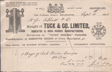 Bendigo Historical Society Inc.
Financial record - Five Bendigo Business Dockets, 1892 - 1902, 31/01/2017
Five Dockets related to operations and purchases by Bendigo Businesses8545a Docket from Tuck & Co. Limited, Asbestos & India Rubber Manufacturers, 4566 Collins Street, Melbourne; Sept. 4th, 1889; Head Office: 116 Cannon Street, London. Purchased 3 Bags of Asb. Boiler ?? at a cost of £3/- by Messrs. Abbitt & Co. 8545b Docket from G. Wood, General Founder, Kensington Iron Foundry, Macauley Road, dated Dec. 2nd, 1896; due from Mr. J. H. Abbott, For 1 doz. combination parts& 1/2 doz. stands for parts at £1/14/00. 8545c Memorandum James Oppy, Boot and Shoemaker, Fitzroy Street, Kerang, dated Aug. 23rd, 1893. Apology and advice the amount owing will be forwarded on 1st of next month (Sept.). 8545d Docket for six items purchased by Messrs. J.H. Abbott, Bendigo for £63/16/00 from The Australian Explosives & Chemical Coy. Ltd on Aug. 5, 1902. Manufacturers and Importers of High Explosives and Detonators, 356 Little Collins Street, Melbourne 8545e Docket / quote from J. Kennon & Sons, Tanners, Curriers & Leather Merchants, 206 Bridge Road, Richmond. October 19th, 1888, quotation sent to Mr. J H Abbott, Leather Merchant, Sandhurst.bendigo businesses, j. kennon and sons, tuck and co, g. wood, james oppy, the australian and chemical coy -
 Kew Historical Society Inc
Map, MMBW, River Yarra Beautification Schemes, c.1913
The Melbourne and Metropolitan Board of Works (MMBW) was established by an act of the Victorian Parliament in 1890 to prepare for and to implement a sewerage and water reticulation system across what was then inner Melbourne, its surrounding and middle distance suburbs, including Kew. The MMBW was disbanded in 1991.The map collection of the Kew Historical Society has at its core the historic maps assembled and originally stored in the City Engineer's Department of the City of Kew. These include maps in a number of scales. The vast majority of maps were produced by the MMBW in the first two decades of the twentieth century, and are solid working maps, backed by linen for durability. These maps are historically significant to Kew, the City of Boroondara and to the history of the development of state utilities in Victoria. A number of the Kew maps have additional details added by former municipal officers, including the levels reached by various floods. As these were working documents, information was added to them long after the period of their initial production and distribution.Map of the City of Kew showing part of the River Yarra Beautification Schemes. The map shows development to date and the flood levels reached in 1923 and 1924. This map may have been adapted from an earlier map, as most development in central Kew and Studley Park had occurred by this date yet numerous streets are not represented. Public buildings and institutions are clearly represented and named on the map as are significant public transport infrastructure (eg the Outer Circle railway).MELBOURNE AND METROPOLITAN BOARD OF WORKS / RIVER YARRA BEAUTIFICATION SCHEMES / SCHEME / SCALE 10 CHAINS TO AN INCHmelbourne & metropolitan board of works, mmbw maps, mmbw plans, city of kew, flood levels -- kew (vic.), cartography -
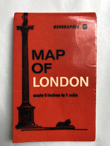 Robin Boyd Foundation
Map, Geographia, Map of London
walsh st library -
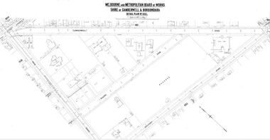 Camberwell Historical Society
Map (Item) - MMBW map, Melbourne and Metropolitan Board of Works, Melbourne and Metropolitan Board of Works - Shire of Boroondara and Camberwell - Detail Plan no. 1852, August 1904
Lithographer L.E, exd W.A.L., August 1904, no. 95. 40P. 15Wmelbourne and metropolitan board of works, map, camberwell, cartography -
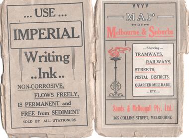
Whitehorse Historical Society Inc.
Map, Sands and McDougall's Map of Melbourne & Suburbs, 1950s
Wall map of Melbourne and suburbs 12-18 mile radius of CBD.Wall map of Melbourne and suburbs 12-18 mile radius of CBD.Wall map of Melbourne and suburbs 12-18 mile radius of CBD.melbourne, maps -
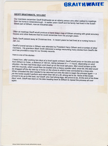 Eltham District Historical Society Inc
Map, Geoff Braithwaite, Braithwaite ma0p of Eltham circa 1920
A3 photocopy of hand drawn map of Eltham created by Geoff Braithwaite (1914-2008) of his memory of the township about 1920. It includes names of streets and property owners. Folder of information on Geoff Braithwaite Includes A3 photocopy of hand drawn map of Eltham with coloured shading of Eltham in 1920s and 1930sharry gilham collection, eltham, 1920, geoff braithwaite, map, smart family cottage, eltham cemetery, flora caroline braithwaite (nee gamble), geoffrey braithwaite -
Port Melbourne Historical & Preservation Society
Map - Aerial view of Port Melbourne, Melbourne Harbor Trust, Apr 1944
Drawing of aerial view of Port Melbourne 1944piers and wharves - miscellaneous, missions to seamen, melbourne harbor trust - port of melbourne authority -
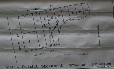 Melton City Libraries
Map, Block details section 21 Township of Melton, 1965
In 1861, Mary Dowling and John Luby obtained Crown Grant land on the corner of Smith and McKenzie Street Melton.Section 21 is covers the block of Smith, Henry and McKenzie Street Meltoncouncil -
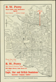 Kew Historical Society Inc
Map - Map of Kew and Hawthorn Districts
Map of Kew, East Kew and Hawthorn produced for a Kew Real Estate Agent, RW Perry. The map is undated.Two-colour map of Kew and Hawthorn Districts produced for by R.L. Jarrett for RW Perry, Real Estate & Insurance Agent. The map has unusual features such as a planned railway link from Kew Station to the former Outer Circle Railway. RW Perry / Real Estate & Insurance Agent, 602 High Street, East Kewmaps - kew (vic), maps - hawthorn (vic), r.w. perry, real estate agents -- kew (vic.) -
 Buninyong Visitor Information Centre
Map, et al, Early Squatters Stations 1837-1838, This map was created in 2016 by a group of U3A Ballarat students under the Tutor, John Olsen
The map shows rivers and pastoral holdings from 1837 to 1838. Stations occupied around Geelong in 1837 are shown in red and those occupied in 1838 are shown in black. Reproduction of a coloured map shows pastoral stations around the Geelong area from 1837-1940. pastoralism, stations, farming, settlement, squatters -
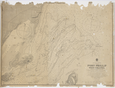 Queenscliffe Maritime Museum
Map - Survey Charts, Port Phillip West Channel
These charts show changes to the depth levels surrounding Queenscliff. Earlier chart does not show the cut which can be seen in the later chart. The creation of the cut and subsequebt dredging of it has changed the shoreline due to shifting sand.Two charts of the Port Phillip West Channel, reference number 309. One was engraved in 1903, the other a new 1935 edition last revised in 1961.Port Phillip West Channelport phillip, queencliff channel, charts, soundings -
Port Melbourne Historical & Preservation Society
Financial record - PMHPS, Pat Grainger, Annual Report 2012, Aug 2012
PMH&PS was incorporated in 1994, and from 1995 was required to hold an AGM and present an Annual Report. These were compiled, designed, printed on photocopier and bound by the Secretary, except for the Tenth anniversary edition and most recent edition, commercially photocopied.Annual Report of the PMH&PS, 2012 A5 Pale grey with aerial photograph of Port Melbourne, including Lagoon. Contains financial reports, list of members and photossocieties clubs unions and other organisations, port melbourne historical & preservation society, pmhps -
Stawell Historical Society Inc
Map, Department of Crown Lands and Survey Victoria, Allotments in the Township of Banyana. Parish of Burrum Burrum. 1946 / 1971, 1971
Richardson River. Avon River JunctionPaper Map of County of BorungReprint of the 1946 edition. Drawn and reproduced at the Department of Crown Lands and Survey Victoria 1971.survey -
 Melbourne Tram Museum
Map, Sands and McDougall Pty Ltd, "Map of Melbourne and Suburbs showing Tramways, Railways, Streets, postal districts, Quarter-Mile Radii etc", c1930
Produced by Sands and McDougall Pty Ltd of Collins St Melbourne. Map - folded sheet of paper 5 sections wide x 6 sections or folds deep contained within a dark grey paper cover titled "Map of Melbourne and Suburbs showing Tramways, Railways, Streets, postal districts, Quarter-Mile Radii etc", showing both cable and electric tramways. verted, but not Market St to Port Melbourne or South Melbourne. Shows the Collins St line being constructed. Collins St routes were opened late 1929, map produced during the early 1930's prior to the closure of Market St - Port Melbourne. Has a detailed list of the postal districts.trams, tramways, maps, melbourne, cable trams, tramways, railways -
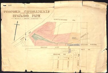 Ringwood and District Historical Society
Map, Proposed Improvements to Ringwood Park (Ringwood Lake) dated 14 January 1927
Proposed Improvements to Ringwood Park (Ringwood Lake) dated 14 January 1927, signed Cr McCaskill. Main Road is Whitehorse Road (Maroondah Highway), and Mt Dandenong Road is incorrectly labelled Whitehorse Road. The map shows Rosedale Crescent and Railway Parade, both of which exist in 2024. On the bottom of the map, south of the railway line, showing proposed streets - Graham Road, Anderson Street and Adams Street - in preparation for the sale of the Theo Anderson property. That area is now Bedford Park. -
Stawell Historical Society Inc
Map, Stawell Gold Mine, Tenement Boundaries Stawell Township 2001, August 2001
Showing Underground Development Stawell Gold Mines Victoria Scale 1 : 20000mining, gold