Showing 5671 items
matching documentation
-
 Eltham District Historical Society Inc
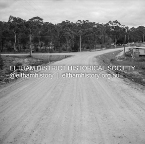
Negative - Photograph, J.A. McDonald, Heidelberg-Kinglake Road, Hurstbridge, Sep. 1959
During reconstruction of approaches looking towards Cherrytree Road junction September 1959Record of various Shire of Eltham infrastructure works undertaken during the period of 1952-1962 involving bridge and road reconstruction projects, sometimes with Eltham Shire Council Project Reference numbers quoted. It was during this period that a number of significant improvements were made to roads and new bridges constructed within the shire that remain in place as of present day (2022). In many situations, the photos provide a tangible visible record of infrastructure that existed throughout the early days of the Shire. The album was put together by or under the direction of the Shire Engineer, J.A. McDonald.infrastructure, shire of eltham, bridge construction, cherry tree road, hurstbridge, road construction -
 Robin Boyd Foundation
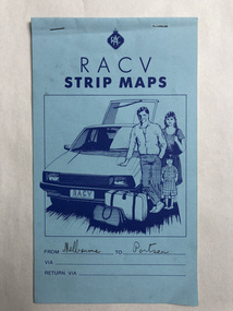
Map, RACV, Strip Maps Melbourne to Portsea
walsh st library -
 Bendigo Historical Society Inc.
Map - BENDIGO WEEROONA GASWORKS MAP/PLAN COLLECTION: DETAILS FOUR PURIFIERS, 1889
Plan/map: Bendigo Weeroona Gaswork, plan showing details four purifiers. Plan signed by ? Thompson engineer, dated 1889. Written on bottom RH: this is one of the drawings referred to in my contract dated .. (undated).plan, bendigo, bendigo weeroona gas works, maps: bendigo weeroona gasworks map/plan collection, gasworks, thompson -
 Federation University Historical Collection
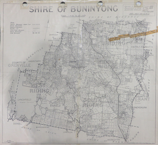
Map, Shire of Buninyong, c1970
The Shire of Buninyong was located on the southern side of Ballarat.Two maps of the Shire of Buninyong. .1) Map showing the County divisions, township boundaries, Railway line, State Forest boundary, riding boundary and shire boundary. Identifying words have been added in red and green texta. .2) Shire of Buninyong Parish Plan. Includes Buninyong, Clarendon, Narmbool, Enfield, Lychfield, SCotchman's, Navigators, Warrenheip, Scotsburn, mr Doran, Durham Lead, Cambrian Hill, Napoleons, Garibaldi, Mt Clear, Lal Lal, Bonshaw.1) B.I.A.E., St Martin's, cemetery, mt Buninyong, mt Innes, rly stn shire of buninyong, buninyong, clarendon, narmbool, enfield, lychfield, scotchman's, navigators, warrenheip, scotsburn, mt doran, durham lead, cambrian hill, napoleons, garibaldi, mt clear, lal lal, bonshaw, state forest, elaine, elaine north, cargerie, grenville, mt mercer, millbrook, wallace, yendon, canadian, kaolin deposits, mount helen campus -
 Marysville & District Historical Society
Map (Item) - Map and touring guide, Murrindindi Regional Tourism Association Inc, Marysville & The Mystic Mountains VICTORIA-AUSTRALIA, 08-2002
A fold out map and touring guide of Marysville and the surrounding district published in 2002 by Murrindindi Regional Tourism Association Inc.A fold out map and touring guide of Marysville and the surrounding district published in 2002 by Murrindindi Regional Tourism Association Inc.marysville, victoria, australia, map and touring guide, mystic mountains tourism, the beeches rainforest walk, lake mountain, cambarville, cathedral range state park, the cumberland, abbey green b&b cottages, anastasia fairytale cottage, ashlar cottage b&b, somerled mountain retreat, baree mudbrick cottages, blackwood cottages, camellia cottage, cathedral view b&b, cottage riverside, crossways country inn, dalrymples guest cottages, esa country ministries, hillcrest, keppels hotel motel, kerami house, lomatia lodge, lyell guest cottages, marylands country house, marysville caravan park, marysville holiday cottages, maryton park, melina cottage, moondai farm b&b, mountain lodge marysville, mount cathedral lodge, mystic mountains holiday cottages, nanda binya lodge, rendezvous on murchison, scenic b&b, the hermitage, tower motel, waratah house, willowbank at taggerty, woodlands of narbethong, keppels, lake mountain resort cafe, lanterns at willowbank, mantirri blueberry farm, marysville country bakery, the old woolshed cafe, clearstream olives, uncle fred & aunty val's old style lolly shop, acheron valley alpacas country store & gallery, bruno's art and sculpture garden, country touch, things of sand & stone, willowbank gallery, marysville auto & hardware, marysville newsagency & general store, marysville visitor information centre, narbethong visitor information centre, gallipoli park, keppels lookout, lady talbot drive, steavenson falls, steavenson river, taggerty river, acheron river, black spur trail riding centre, buxton trout farm, lake mountain resort ski hire, lake mountain ski school, marysville district country club, marysville ski centre, narbethong ski hire, rubicon horse riding, country touch tours, murrindindi regional tourism association inc -
Bendigo Historical Society Inc.
Plan - MARKS COLLECTION: PLAN OF ALTERATIONS AND ADDITIONS TO THE PRIVATE RESIDENCE OF GEO. LANSELL ESQR
Plan for the alteration and additions to Fortuna Villaa, the private residence of George Lansell Plan shows southern, eastern & western elevations, floor and roof plan for the additions to the residence Coloured hand drawn construction plan Plan is undated plan has severe damage on LHS and bottom of the sheet -
 Ballarat Tramway Museum
Negative - Set of 2, Campbell Duncan, 10/08/1971 12:00:00 AM
Yields information about tram operations and the street views in the Victoria St and St Alipius churchSet of 2 photographs taken on 10/8/1971 by Campbell Duncan of No. 13 in-bound in Victoria St, passing St Alipius church and School.trams, tramways, victoria st, st alipius, tram 13 -
Whitehorse Historical Society Inc.
Map, Anjaya Court, Blackburn, ca1970
[Plan of] Anjaya Court, Blackburn, Lots 6 - 20and of Leons Court, Lots 21-24. One copy with proposed sewerage plan.anjaya court, blackburn, land subdivision, sewerage and sanitation -
University of Melbourne, Burnley Campus Archives
Plan, Plans for courtyards at a hospital. Courtyards 1, 2 and 3; 4; 5 ; 6; Typical Courtyard sections; Functional areas
-
 Kew Historical Society Inc
Plan, Melbourne & Metropolitan Board of Works : Borough of Kew : Detail Plan No.1291, 1905
The Melbourne and Metropolitan Board of Works (MMBW) plans were produced from the 1890s to the 1950s. They were crucial to the design and development of Melbourne's sewerage and drainage system. The plans, at a scale of 40 feet to 1 inch (1:480), provide a detailed historical record of Melbourne streetscapes and environmental features. Each plan covers one or two street blocks (roughly six streets), showing details of buildings, including garden layouts and ownership boundaries, and features such as laneways, drains, bridges, parks, municipal boundaries and other prominent landmarks as they existed at the time each plan was produced. (Source: State Library of Victoria). This plan forms part of a large group of MMBW plans and maps that was donated to the Society by the Mr Poulter, City Engineer of the City of Kew in 1989. Within this collection, thirty-five hand-coloured plans, backed with linen, are of statewide significance as they include annotations that provide details of construction materials used in buildings in the first decade of the 20th century as well as additional information about land ownership and usage. The copies in the Public Record Office Victoria and the State Library of Victoria are monochrome versions which do not denote building materials so that the maps in this collection are invaluable and unique tools for researchers and heritage consultants. A number of the plans are not held in the collection of the State Library of Victoria so they have the additional attribute of rarity.Original survey plan, issued by the MMBW to a contractor with responsibility for constructing sewers in the area identified on the plan within the Borough of Kew. The plan was at some stage hand-coloured, possibly by the contractor, but more likely by officers working in the Engineering Department of the Borough and later Town, then City of Kew. The hand-coloured sections of buildings on the plan were used to denote masonry or brick constructions (pink), weatherboard constructions (yellow), and public buildings (grey). A detail plan of part of Studley Park bordered by the major streets of Hodgson Street, Stevenson Street and Studley Park Road. Included on the plan are a number of significant Studley Park mansions in existence at the beginning of the 20th century. The unnamed street shown in the middle of the plan is McEvoy Street. The most important house still extant is Campion House, formerly named Dalsraith [Dalswraith] and Glendalough, owned since the 1940s by the Society of Jesus. Campion House can be seen on the corner of Hodgson and Studley Park Road. Its stables at the rear of the block have now been incorporated into a contemporary residence. An interesting feature of the plan is the 1910 annotation by Ed Seitz, professional designing engineer. Is Seitz the contractor who modified the MMBW original?melbourne and metropolitan board of works, detail plans, mmbw 1291, cartography -
Moorabbin Air Museum
Plan (item) - C.A.C Plan XP.64
-
Whitehorse Historical Society Inc.
Map, Blackburn and Nunawading Map, 1960's?
Map of Blackburn and Nunawading.Map of Blackburn and Nunawading.Map of Blackburn and Nunawading.maps, blackburn, nunawading -
 Eltham District Historical Society Inc
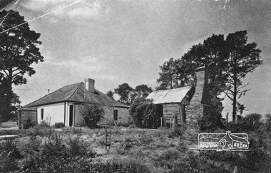
Negative - Photograph, Home Beautiful (United Press), Thomas Sweeney's original cottage at Culla Hill, Eltham, 1940
Feature article in Home Beautiful magazine (c.1940) on the original Sweeney's Cottage at Culla Hill built by Thomas Sweeney, one of the district's pioneer settlersRoll of 35mm black and white negative film, 3 stripsKodak Safety 5062culla hill, eltham, home beautiful magazine, houses, sweeney's cottage, sweeneys lane, thomas sweeney -
Stawell Historical Society Inc
Map, CFA, Map of Stawell / deep Lead Fire of 31/12/2005, 2006
Fire Started from lightning strike near Deep Lead and Burned on New years Eve with nasty North Wind, Southerly to Black range, Then Easterly towards Great western. Fire Subduded by Rain Event on 2/1/2006.Laminated Coloured Map of Stawell / Deep Lead 4/1/2006 with Fire Perimeters.CFA GIS Services Community Services -
 Bendigo Military Museum
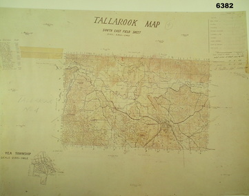
Map - Australian Topographical Survey TALLAROOK SE Sheet, 1 inch:1 Mile, NW portion Plane Table Field sheet 1923, Australian Survey Corps, 1923
This is a coloured reproduction print of an original Plane Table compilation map sheet of Tallarook area 1inch to 1 Mile scale compiled by Sgt Jack Cullen Australian Survey Corps 12 November 1923 and signed by Capt J Lynch. Capt Lynch and Sgt Cullen were both foundation members of the Australian Survey Corps. Of particular interest is the fact that this is a heighted compilation with contouring (required for Military use) as many early maps were purely planimetric. The reverse side of this print is a copy of the Nagambie plane table South West field sheet.Reprinted coloured Image of Australian Topographical Survey TALLAROOK SE field Sheet,1 inch:1 Mile, hand drawn contoured Plane Table Field sheet. Signed by Sgt J Cullen Australian Survey Corps November1923. An enlargement of YEA Township 2 Inches to 1 Mile Scale.royal australian survey corps, rasvy, fortuna, army survey regiment, army svy regt, asr -
University of Melbourne, Burnley Campus Archives
Plan, C.E. Richardson, Burnley Gardens, 1965
5 printed plans with buildings marked in black. Drawn by C.E. Richardson, P.R.L. 6th August, 1965, amended 1st December, 1965. Marked: Project No 1 (Engineering Building) and Project No 2 (Plant Sciences Building.) burnley gardens, buildings, burnley school of horticulture -
Stawell Historical Society Inc
Map, Bellaura, County of Borung, 1924
Bellaura, County of Borungstawell -
 City of Greater Bendigo - Civic Collection
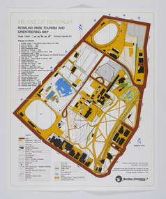
Map - Rosalind Park and surrounds
city of greater bendigo tourism, rosalind park, faith leech memorial swimming pool, city of greater bendigo events -
 Bendigo Military Museum
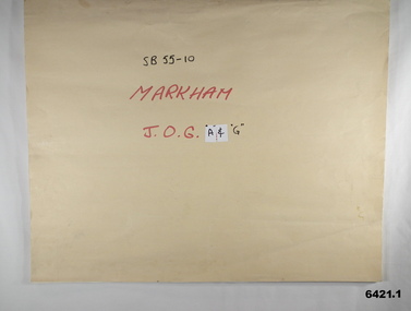
Map - SB55-10 Markham Joint Operations Graphics Air and Ground print separations, Royal Australian Survey Corps, Bendigo, Dec 1981
This set of map prints was assembled as a training aid. The collection is a complete set of individual color prints of each colour used on the final printed maps for each map Joint Operations Graphic (JOG) JOG Ground and JOG Air versions. This map series was produced in two versions to help coordinate military Ground Operations and Air Operations. The ground users required that heights and measurements were in Metres, whilst air users required height information in Feet for altimeters. The Air Version also contained more Aeronautical information including safe flying height information called Maximum Elevation Figures (MEF). Later printing of JOG incorporated printing in just four colours Cyan, Magenta, Yellow and Black (CMYK). Item 6421.1 is an example of a JOG Ground and item 6421.2 is an example of its matching JOG Air version.1:250,000 SB55-10 Markham JOG A and G colour separations bound together in a manilla card covered folder bound with a timber edge. royal australian survey corps, rasvy, fortuna, army survey regiment, army svy regt, asr -
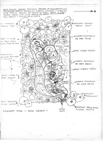 University of Melbourne, Burnley Campus Archives
Plan, Kath Deery, Concept Plan - Kath Deery - Bush Tucker Garden, C. 1980
-
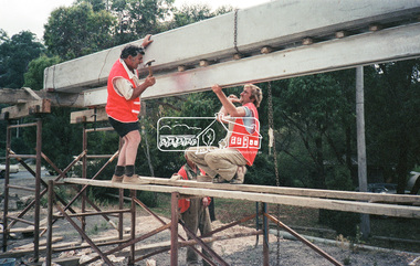 Eltham District Historical Society Inc
Negative - Photograph, Construction work, Main Street Bridge, Greensborough, c.Dec. 1983
The original bridge over the Plenty River was replaced by a single lane bridge each way fed by two lanes each way on either side. As traffic grew a second bridge was added to complete the divided road across the riverFilm - Kodak CM 400 5079 7 strips, 26 framesinfrastructure, roads, bridge construction, greensborough, main street bridge, road construction -
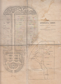 University of Melbourne, Burnley Campus Archives
Plan, Alfred Lynch, Plan of the Experimental Gardens of the Horticultural Society of Victoria. Survey Paddock. Richmond, 1861
Subsequently the area was not fully developed in this manner following flooding in 1863. Some remnants remain.Plan on paper with cloth backing. Inscription, "Designed by Alfred Lynch. Landscape Gardener, Prahran. Printed by De Guchy & Leigh." An inset plan shows position of Experimental Gardens related to the City of Melbourne and Bay. Plan shows layout and plantings of the designated area - fruit, vegetables: the conservatory, nursery, exhibition buildings. This plan was owned by E.E. Pescott. Inscription on cover, "Burnley. E.E.P.." "Ed. E. Pescott." Subsequently the area was not developed in this manner. See inscription on copy made for Centenary Exhibition B92.633. Other copies given to College by N. Lothian (graduated 1934). Jim Sanders, a friend of his, gave them to Dr. G. Moore in 1991. A larger copy, inscribed on reverse, '1861', 'Early proposals for Horticultural Gardens for Horticultural Society of Victoria (now Royal). The lithograph was included as an insert in the Farmers Journal and Gardeners Chronicle 21 June, 1862. It is only in one of the copies held by the State Library of Victoria. 1 large and 1 small photographs of plan. Several photocopies of the plan.Inscription, "Designed by Alfred Lynch. Landscape Gardener, Prahran. Printed by De Gruchy & Leigh." / Inscription on cover, "Burnley. E.E.P.." "Ed. E. Pescott."alfred lynch, experimental gardens, conservatory, nursery, e.e. pescott, n. lothian, jim sanders, dr. g. moore, horticultural socoety of victoria -
University of Melbourne, Burnley Campus Archives
Plan - Planting Design, Cul-de-sac Planting Design, Nov 2020
john rayner, garden plan, plant list -
Stawell Historical Society Inc
Map, Township of Stawell, County of Borung, 1958
Township of Stawell, County of Borungstawell -
Moorabbin Air Museum
Map (Item) - Maps of Northern Australia and New Guinea, AUS RNC 5 and 6 radio navigation maps
-
Bendigo Historical Society Inc.
Map - WESTON RESURVEY, June 20th 1875
Map: Weston, Resurvey.Hand draughted Parish plan (number 292 in map cupboard 1)map, parish plan, weston -
Port Melbourne Historical & Preservation Society
Plan - Conceptual Perspective Drawings, Port Melbourne Yacht Club, Taylor Howden Pty Ltd, Architects, 1990s
Port Melbourne Yacht Club .01 - 02 Clubhouse reconstruction conceptual perspective drawings sport - yachting, built environment - recreational facilities -
Glen Eira Historical Society
Plan - Clarinda Street, 27, Caulfield South
A one page typed letter from Plante and Henty Solicitors on behalf of the Executor of the will of the late Grace Ellen Gillespie, to W V Scott of S P Simmonds and Co, dated 04/03/1957, requesting valuation of 27 Clarinda Street, Caulfield South for Probate purposes. The letter is accompanied by the Certificate of Title for the property which includes a map (87mm x 67mm) of the property. It is also accompanied by a floor plan (300mm x 205mm) of the house. The file also includes a two page copy of correspondence from W V Scott to Plante and Henty, dated 22/03/1957, providing the valuation of 27 Clarinda Street. The file also includes three pages of handwritten working notes for the purposes of the valuation which provide dimensions and estimated value of the property.scott w v, gillespie grace ellen, clarinda street, solicitors, s p simmonds and co estate agents, property values, land values, plans, architectural features, land titles, certificates, caulfield south, prahran east, elsternwick county of bourke, sycamore road, south caulfield, glenhuntly road -
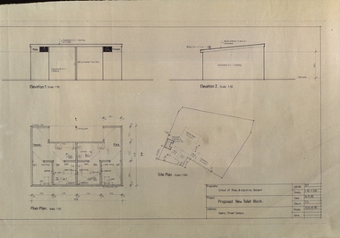 Federation University Historical Collection
Plan, Ballarat School of Mines Proposed New Toilet Block, Barkly Street Campus, 1985, 16/08/1985
Plan showing plans for a toilet block at the former Ballarat East High School, Barkly Street.ballarat school of mines, barkly street campus, ballarat east secondary college, toilet block, architectural plans -
Stawell Historical Society Inc
Map, Mokepilly, County of Borung, Shire of Stawell, 1957
Mokepilly, County of Borung, Shire of Stawellstawell