-
 Melbourne Tram Museum
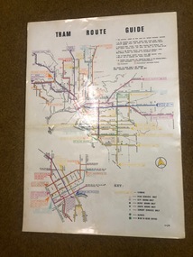
Map, Melbourne & Metropolitan Tramways Board (MMTB), "Tram Route Guide", Jun. 1982
Full colour map or poster printed on clear plastic with an adhesive peel off backing sheets, titled "Tram Route Guide". Map dated 6/82, showing routes with route numbers and names of main destinations. Has notes about the services, weekend bus replacements and telephone numbers for information. 1982 Note this version does not show the route 88 extension as similar map 1098 or 3765 does, but is a later version.trams, tramways, mmtb, map, routes, posters -
 Marysville & District Historical Society
Map (Item) - Tourist map, Mystic Mountains Tourism, OFFICIAL VISITORS' MAP MARYSVILLE LAKE MOUNTAIN, Unknown
A visitors' map of Marysville and Lake Mountain produced by Mystic Mountains Tourism for Visit Victoria.A visitors' map of Marysville and Lake Mountain produced by Mystic Mountains Tourism for Visit Victoria.The Marysville and Lake Mountain Visitor Map and Touring Guide has been compiled and/ published by Mystic Mountains Tourism Inc. Copyright./ Production and artwork Graph Attack P/Lmarysville, lake mountain, victoria, australia, visitor's map, official visitors' map marysville lake mountain, buxton, narbethong, taggerty, visit victoria, mystic mountains tourism inc, graph attack p/l, mystic mountains, marysville triangle, marysville visitor information centre, marylands country house, black spur, steavenson falls, lady talbot drive, cambarville, cathedral ranges, wirreanda festival, lake mountain summit walk, summit walk loop, leadbeaters loop, day loop walk, buxton hotel, igloo roadhouse, karmann waters, silverstream b&b cottages, buxton trout and salmon farm, the niche wine bar, buxton post office & general store, choppers buxton roadhouse, woodlands rainforest bungalows, chestnut glade, black spur inn, wombat cottage, abbey lake luxury b&b spa cottages, mystic mountain ski hire & outdoors, pnl 4wdriving, blue views holiday units & ski hire, marapana agistment park & farm stay b&b, danico design, things of sand & stone, mantirri blueberry farm, allawah country cottages, amberview cottages, ashlar cottage b&b, black spur motel & caravan park, blackwood deluxe cottages, blackwood courtyard b&b, dalrymples guest cottages, delderfield, el kanah guest house, fruit salad farm, kerami guest house, keppels hotel, lake mountain-snow gum lodge, lomatia lodge, lyell guest cottages, magnolia house, keppel waters, lyrebird apartments, marysville caravan park, all view spa apartments, riverside cottages, maryton park b&b country cottages, melina cottage, mountain lodge, mystic mountains holiday cottages, nanda binya lodge, rendezvous luxury cottages, scenic b&b motel, the cumberland, south cathedral farm, tower motel, willowbank at taggerty, woodlands rainforest retreat, marysville & district country club inc, mystic mountains ski hire & outdoors, rubicon valley horse riding, marysville trout and salmon ponds, gallipoli park, keppels lookout, cambarville-yarra ranges national park, lake mountain-yarra ranges national park, lady talbot drive-yarra ranges national park, cathedral range state park, steavenson river, taggerty river, acheron river, lake mountain alpine resort, bruno's art and sculpture garden, manical mechanicals, uncle fred & aunty val's old style lolly shop, carmyle farm boutique, crossways historic country inn, fraga's, gilberts restaurant, heights licensed bistro, the old woolshed cafe, cathedral view natural therapies, crystal journey -
 Melbourne Tram Museum
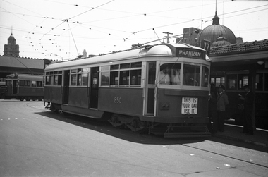
Negative, Wal Jack collection, 1939
Black and white negative by Wal Jack of SW6 class 850 at the Princes Bridge terminus. The tram entered service 31/3/1939. Photo c1940. The microphone can be seen in the front window. Note no windscreen wiper. Tram running a route 77, Prahran. Has tail lights and dash canopy lighting with the sign "This is you car use it" underneath. The front number can just be seen. In Swanston St and adjacent are W2's. Other photos of the tram in the album are dated 1939, possibly late 1939 given it appears to a summer's day.trams, tramways, shelters, princes bridge, sw6 class, dash canopy lights, new tramcars, batman ave, tram 850 -
 Ballarat Tramway Museum
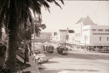
Negative - Set of 3, Campbell Duncan, 10/08/1971 12:00:00 AM
Yields information about tram operations and the street views in the area of the City Loop, Sturt St.Set of 3 photographs taken on 10/8/1971 by Campbell Duncan of trams in the City Loop area of Sturt St. .1 - With 5 trams, headed by No. 40, in the loop, No 26 passes the loop. In the background are the various shops and stores on the south side of Sturt St, the including Patersons store. .2 - No. 26 climbing towards Lydiard St with the Coors Private Hotel, the Commonwealth Bank and the National Mutual building in the view. The tram has the destination of Gardens via Sturt St West, and a Briquettes roof advertisement. .3 - No. 27 - passes the assembled trams in the loop with the Dickins and Thomas buildings in the background. The tram has a Twin Lakes sign.trams, tramways, sturt st, city loop, tram 26 tram 40 tram 27 -
 Bayside Gallery - Bayside City Council Art & Heritage Collection
Map, Department of Lands and Survey, Land under the control of the City of Sandringham, 1962
The cadastral map showing land under the control of the City of Brighton in 1962.map, plan, foreshores, sndringham, hampton, beaumaris, cheltenham, department of lands and survey, cartographic material, moorabbin, black rock, street map, city of sandringham, board of lands and works -
 Lakes Entrance Regional Historical Society (operating as Lakes Entrance History Centre & Museum)
Financial record - Ledger, Mitchell Cash Book, 26 May 1891
Entries are hand written in ink, book is filled to capacity of 191 pages, leather bound with heavy cardboard cover.A ledger containing various accounting details for Bairnsdale district of Manchester Unity Independent Order of Oddfellows (MUIOOF).accounts book -
 St Kilda Historical Society
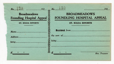
Financial record - Receipt form, Broadmeadows Founding Hospital Appeal, 1920s
Unused receipt forms that have been removed from a receipt book for St Kilda's contributions to an appeal in aid of the Broadmeadows Foundling Hospital Appeal.Blue coloured paper, printed in black on one side, perforated vertically at about one third along its length. Ten copies heldbroadmeadows foundling hospital, hospital fundraising -
Whitehorse Historical Society Inc.
Map, Mitcham Road, c1970
Enlarged aerial photo of the intersection of Mitcham and East Doncaster Roads, Mitcham. Scale 1 inch : 40 feet.Enlarged aerial photo, c1970, of the intersection of Mitcham and East Doncaster Roads, Mitcham. Scale 1 inch : 40 feet.Enlarged aerial photo of the intersection of Mitcham and East Doncaster Roads, Mitcham. Scale 1 inch : 40 feet.mitcham road, mitcham, quarry road, mitcham, doncaster east road, mitcham, wooddale grove, mitcham, mitcham primary school, no. 2904, aerial photographs -
Port Melbourne Historical & Preservation Society
Map - VACCUUM Road Guide to Victoria
The Mathews family have been in continuous ownership of 395 Howe Parade (was 8 Howe Parade until 1964 when addresses re-assigned), Port Melbourne from 1938 to the present (Sept 2019)Six folders of assorted documents relating to the life of Alan Mathews and his family. Employment documents. Folder 4 has Motor car purchases, Registration, Licences & RACV Road map. VACCUUM Road Guide to Victoriatransport - motor vehicles, alan mathews, commonwealth aircraft corporation, cac -
 Bendigo Historical Society Inc.
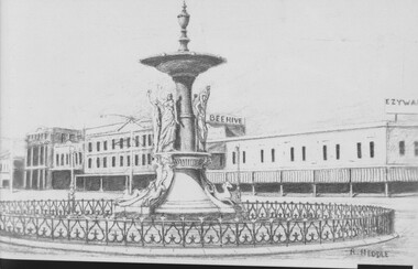
Negative - TOM PATULLO COLLECTION: ALEXANDRA FOUNTAIN,BENDIGO
Negative print. Alexandra Fountain,Bendigo. Ezywalkin Shop to the right, Beehive shop behind fountain, & other buildings along Pall Mall,Bendigo. Printed by R.Heddle.cottage, miners, alexandra fountain, bendigo., alexandra fountain, bendigo. -
Bendigo Historical Society Inc.
Map - VICTORIA, Circa 1926
Map: Map showing Counties, including Railway lines and Geographic features. Compiled and engraved at the Department of Lands and Survey Melbourne, Revised October 1926 ( number 184 in Map Cupboard 1)map, victoria, counties, counties of victoria, geographic features -
 B-24 Liberator Memorial Restoration Australia Inc
Map - British World War II silk map of Sumatra (South) and Java (Extreme North West), 1944
Silk and rayon maps were produced by Great Britain (some 1.75 million in total), the United States (c.7.5 million) and Australia during World War II. They were issued to Allied military personnel as part of 'escape and evasion' kits.This map, printed on rayon, is an original British 'escape and evasion' kit map from World War II.A multi-coloured, contoured, double-sided map printed on rayon, 1944 Series South West Pacific Area (SWPA) and Asia Sheet G Sumatra (South) and Java (Extreme North West) and, on the reverse, Sheet H Borneo (South West), Java and Sumatra (Extreme South)world war ii, silk maps, great britain, a187 -
Whitehorse Historical Society Inc.
Map, City of Nunawading, n.d
Map of the City of Nunawading with streets and railway stations namedMap of the City of Nunawading with streets and railway stations named Scale 1 mile = 3.75 inMap of the City of Nunawading with streets and railway stations named city of nunawading, maps -
 Eltham District Historical Society Inc
Negative - Photograph, Open Day, Eltham Living and Learning Centre, 7 Nov 1987
Open Day, Eltham Living and Learning Centre, part of the Eltham Community Festival activites, 7 Nov. 1987eltham, eltham festival, eltham living and learning centre, living and learning centre, open day -
 Eltham District Historical Society Inc
Negative - Photograph, Hillview Court, Kangaroo Ground, looking east from end of street, 1998c
Roll of 35mm colour negative film, 8 strips and associated 10 x 15 cm colour printKodak Gold 100-5hillview court, kangaroo ground -
Glenelg Shire Council Cultural Collection
Financial record - Receipt - Insurance for the Portland Free Library, 18/09/1919
Receipt from Queensland Insurance Company, Limited to Portland Free Public Library Library Institute, for Public Risk PolicyFront: '1703' - black ink, top rightinsurance, financial records, portland free library -
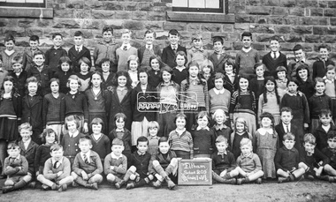 Eltham District Historical Society Inc
Negative - Photograph, Grades 1-6, Eltham State School No. 209, 1935
Doug Orford situated at lower left front. Names of people identified: Back Row (standing) L-R: - , - , - , - , - , - , - , - , - , - , - , Sidney Waples, Bill Fordham, - , 4th Row (standing) L-R: - , - , - , - , - , - , - , - , - , - , - , - , - , Fay Moat , 3rd Row (standing) L-R: - , - , - , - , - , - , - , - , - , Roma Moat , - , - , - , - , 2nd Row (kneeling) L-R: - , - , Joan Crick, Betty Bradford, - , - , Joan Bradford, Pat Dosser, - , - , - , - , - , Front row (seated) L-R: Doug Orford, Lindsay McColl, Ron Orford, Frank Fordham, Thomas White, - , - , David Dosser, - Murray Rains, - , Sidney Waples' father was killed by a Lyons bus during the war whilst walking along the footpath at evening time. He was not seen due to the blackout of lights.Roll of 35mm colour negative film, 3 strips Associated print from negative (Copy of original print)Fuji 100eltham primary school, state school no. 209, eltham state school, eltham state school no. 209, betty bradford, bill fordham, david dosser, doug orford, fay moat, frank fordham, joan bradford, joan crick, lindsay mccoll, murray rains, pat dosser, roma moat, ron orford, sidney waples, thomas white -
Bendigo Historical Society Inc.
Map - CAMPBELL COLLECTION: BENDIGO AND DISTRICT MAPS, 6-4-28
Map. Sedgwick, Parishes of Strathfieldsaye, Lyell, and Sedgwick. Scale 20 chains to 1 inch. Total area 5372 acres. Prepared in W.P.B. from C.L.and A. Plans by W.J.Galbraith 6-4-28. (number 400 in map cupboard 1)W.J.Galbraith.map, bendigo, agricultural lands -
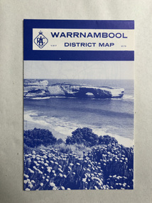 Robin Boyd Foundation
Map, RACV, Warrnambool District Map
walsh st library -
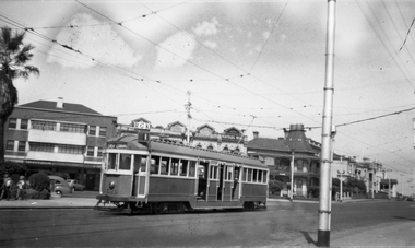 Melbourne Tram Museum
Negative, Wal Jack, c1954
Black and white negative, by Wal Jack, of W2 529 in Beaconsfield Parade, St Kilda at the tram terminus for route 1 tram. Has the buildings in Fitzroy St in the background. The tram has the destination of route 1, East Coburg. c1954? On the buildings are "RGK", a Coffee Lounge, D F Reszke Cigarettes, Penfolds Winestrams, tramways, w2 class, beaconsfield parade, fitzroy st, route 1, tram 529 -
Stawell Historical Society Inc
Map, Agricultural Area of Lake Wilson, Parishes of Bellaura & Bellellen, 1865
Agricultural Area of Lake Wilson, Parishes of Bellaura & Bellellenstawell -
Glenelg Shire Council Cultural Collection
Negative - Glass Plate Negative - Bridgewater, c. 1890
Glass plate negative. Image shows a group of people on flat rocks at Bridgewater. -
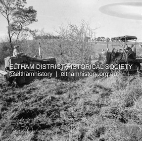 Eltham District Historical Society Inc
Negative - Photograph, J.A. McDonald, Kangaroo Ground-Queenstown Road, Aug. 1960
(Kangaroo Ground-St Andrews Road) “Rymers” Corner – shifting Hawthorn hedges on Tompkins property Council’s Drott 6 Woods Drott 9 August 1960Record of various Shire of Eltham infrastructure works undertaken during the period of 1952-1962 involving bridge and road reconstruction projects, sometimes with Eltham Shire Council Project Reference numbers quoted. It was during this period that a number of significant improvements were made to roads and new bridges constructed within the shire that remain in place as of present day (2022). In many situations, the photos provide a tangible visible record of infrastructure that existed throughout the early days of the Shire. The album was put together by or under the direction of the Shire Engineer, J.A. McDonald.infrastructure, shire of eltham, 1960-08, garden hill, kangaroo ground, kangaroo ground-queenstown road, kangaroo ground-st andrews road, rymers corner, bulldozer, drott -
Whitehorse Historical Society Inc.
Map, Deakin, 1977
Map of the Commonwealth Electoral Division of Deakin. Scale 1: 25,000.Map of the Commonwealth Electoral Division of Deakin. Scale 1: 25,000.Map of the Commonwealth Electoral Division of Deakin. Scale 1: 25,000.electoral boundaries, deakin (commonwealth electoral division), australia. parliament -
Stawell Historical Society Inc
Map, Gold Mines of Australia, Plan of Stawell Goldfield. Mining Leases, 1952
And Shaft Locations 1952 G G Birch Mining Surveyormining, gold, map -
 Eltham District Historical Society Inc
Negative - Photograph, J.A. McDonald, Heidelberg-Kinglake Road, Sep. 1959
Job 56M430 Contractor Hone Deviation opposite looking north from Hurstbridge endRecord of various Shire of Eltham infrastructure works undertaken during the period of 1952-1962 involving bridge and road reconstruction projects, sometimes with Eltham Shire Council Project Reference numbers quoted. It was during this period that a number of significant improvements were made to roads and new bridges constructed within the shire that remain in place as of present day (2022). In many situations, the photos provide a tangible visible record of infrastructure that existed throughout the early days of the Shire. The album was put together by or under the direction of the Shire Engineer, J.A. McDonald.infrastructure, shire of eltham, road construction, 1959-09, heidelberg-kinglake road -
Whitehorse Historical Society Inc.
Map, Boronia Road, Vermont, 1970
Enlargement of aerial photograph of Boronia Road, Vermont. State Aerial Survey 1970 Run 37Enlargement of aerial photograph of Boronia Road, Vermont. State Aerial Survey 1970 Run 37Enlargement of aerial photograph of Boronia Road, Vermont. State Aerial Survey 1970 Run 37boronia road, vermont, lusk drive, vermont, morack road, vermont south, allison court, vermont, trinian street, vermont, cosgrove street, vermont, mawson court, vermont, aerial photographs -
Whitehorse Historical Society Inc.
Map, Melbourne Geological Map, 1937
Geological Map of Melbourne & Suburbs.Geological Map of Melbourne & Suburbs. Scale: 40 chains to 1 inch with inset 10 miles to 1 inch. Includes Municipal and Parish boundaries, railways and stations, electric tramways, cable tramways, Post Offices and State schools. Area bounded by Braybrook, Preston, Blackburn & Brighton. Printed on linen.Geological Map of Melbourne & Suburbs. melbourne, maps -
Clunes Museum
Financial record - BANK RECORDS, 1916-1979
The first Government controlled savings bank was established on 1 January 1842 under New South Wales legislation. Known as the Savings Bank of Port Phillip it was administered by a Board of Trustees and a Vice-President. Branches of this Bank were subsequently established in other parts of the colony. In 1853 a statutory body known as The Commissioners of Savings Banks in the Colony of Victoria was constituted under the Savings' Bank Act and each bank was thereafter to be a separate and independent institution with its own trustees and officers - however, between 1896 and 1912 the independent Savings Banks of Victoria merged to become a single institution and this development was formalised by the 1912 legislation. From 1980 the Bank was known as the State Bank of Victoria under the provisions of the State Bank Act 1980. The State Bank of Victoria established its own Archives before the Bank was sold in 1990 to the Commonwealth Bank of Australia. After the sale, the Archives of the State Bank continued to operate until the Archives' holdings were transferred to the state archives.Bundles of papers from the State Savings Bank, Clunes - Loss of Pass Book Notices 1918-1961 - Deceased Estates 1916-1965 - A/C Stops 1923-1961 - Passbook Cheque Book 1949 - Stat Dec 1946 - Dep. Book School Bank 1978-1979 - Pass Books (2) 1953-1968 and 1948-54state savings bank of victoria, bank documents -
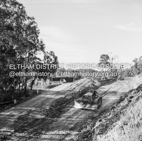
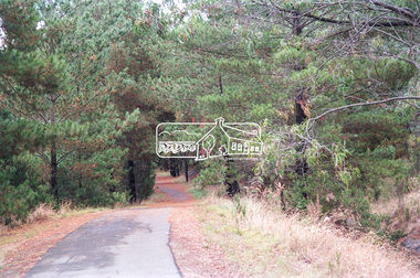 Eltham District Historical Society Inc
Negative - Photograph, Maroondah Aqueduct Trail west of Ingrams Road, Research, 1991
Roll of 35mm colour negative film, 9 strips Colour print 10 x 15 cmFuji HG 200 CA-1ingrams road, maroondah aqueduct, maroondah aqueduct trail, research (vic.)