-
 Lara RSL Sub Branch
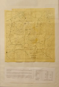
Map, Framed Map of the western front 1914-1918, Map made by G.F.Trudgion R.A.E. circa 1916
Map showing position of western front line in 1914 at the start of WW1Map is from circa 1916 showing battle area of the Western Front during WW1Map of the western front 1914-1918North West Europe Shewing the Western Front 1914-1918 War. Below is description of Australian ANZAC's on Western Front and a graph on Comparison of Casualties from Major Western Front Battlesmap, g.f.trudgion, r.a.e., western front, ww1, world war one, north west europe, 1914, 1916, ww1 casulaties -
 National Wool Museum
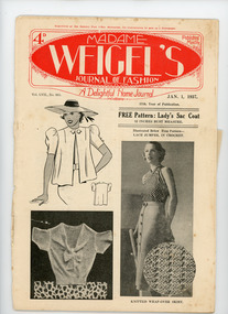
Journal, Madame Weigel's Journal of Fashion, Jan. 1, 1937
This book and a number of others like it were owned by the mother and aunts of the donor, Mrs Dorothy Boyle. They were prolific producers of hand knitted and hand made items of clothing and also knitted and sewed for the armed forces during the Second World War. This book is a monthly journal of fashion and patterns produced by Madame Weigel's Pty Ltd in Melbourne.Registered at the General Post Office Melbourne, for transmission by post as a Newspaper. / 4D / Published / Monthly. / MADAME / WEIGEL'S / JOURNAL OF FASHION / A Delightful Home Journal / Vol. LVII., No. 683. / JAN. 1, 1937. / 57th Year of Publication. /knitting handicrafts - history crochet fashion, madame weigel pty ltd, knitting, handicrafts - history, crochet, fashion -
 Robin Boyd Foundation
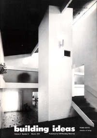
Journal, Jeffrey Turnbull, Building Ideas, Vol 5 No 5, 1973
Volume entitled 'Robin Boyd Visions of Living', compiled by Jeffrey Turnbull in memory of Robin Boyd. It contains excerpts from 'Living in Australia' published as a tribute following Boyd's death.building, architecture, jeffrey turnbull, walsh st library, tribute -
 Warrnambool and District Historical Society Inc.
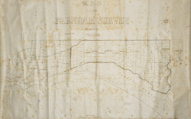
Map - Farnham Survey, 1850s
This is a map of the Farnham Special Survey. In 1843 William Rutledge purchased this Special Survey of 5,120 acres and named it Farnham. This Survey extended from Tower Hill to the Merri River at Dennington. The map appears to date from the 1850s This early map is of considerable significance as it shows details of the Farnham Special Survey. William Rutledge and his survey are important influences in the development of Warrnambool and district with the establishment of settlements at Killarney, Yangery and Tower Hill.A hand drawn map on waxed paper in brown, black and blue ink. It shows Armstrong's Bay, sea, Crown Land , the names of properties and some roads. It includes a compass direction diagram.farnham special survey -
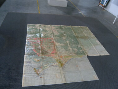
 Stawell Historical Society Inc
Map
Special Allotments, Reefs, Pleasant Creekstawell -
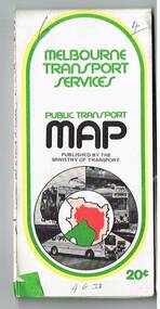 Melbourne Tram Museum
Map, Ministry of Transport, "Melbourne Transport Services Map - Tram, Train and Bus Services", 1975-1976
Fold out map (27 sections 9 across x 3 deep), coloured of Melbourne's Tram and Bus routes, route numbers, rail lines, detailed for the central part of Melbourne and insert section for Frankston. On rear description of routes, private bus routes and map of Melbourne metro lines. Has contact details for bookings and lost property etc. Priced 20c possible 1975-1976 - has 1041 and silver train on front cover.On front cover in ink "3" in top right hand corner and "4 G 33 " along bottom edge.trams, tramways, melbourne, map, tram & bus services, railways, mmtb, minister for transport -
Whitehorse Historical Society Inc.
Map, City of Nunawading, c1975
Map of City of Nunawading, showing location of 186 parks and reserves.Map of City of Nunawading, showing location of 186 parks and reserves. Scale 1:10,000 with list of streets and their map coordinates.Map of City of Nunawading, showing location of 186 parks and reserves. city of nunawading, parks and reserves -
Whitehorse Historical Society Inc.
Map, Map of Vermont area, c1895
Photocopy of part of a larger map showing the Vermont area.Photocopy of part of a larger map showing the Vermont area. Note on side 'after 1892'. Shows land holders.Photocopy of part of a larger map showing the Vermont area.maps, vermont -
Federation University Historical Collection
Map, Geological Map (Southern Western Australia)
A section of a map showing geology and routes of exploration. Southern Western Australia only western australia, perth, geology, exploration -
Kew Historical Society Inc
Journal, Kewriosity : December 1990
Play equipment brochure / p1. Council to review Community Information Service / p1. Rates reminder / p1. Dates for December / p2. Don't bin it, bag it / p2. Hard rubbish collection to continue / p2. Women's Health Day / p2. Kewriosity / p2. Commentary / Cr Daryl Oldaker p3. Cuts threaten Traffic School / p3. Christmas cards / p3. No cost calendars / p3. Bubble and Squeak / p4. [St George's] Hospital records good finance result / p4. Community organisation for young [Rotaract] / p4. Council offers relief care / p4. Teenage holiday program January 1991 / p4. Deteriorating vision may mean danger / p5. Facelift for YRC [Youth Resource Centre] / p5. Time out for myself [Kew Community House] / p6. Council holiday services / p6. What happens to medical waste? / p6. Music a tradition at local school [East Kew Primary School Band] / p7. Carols by candlelight / p7. Sports success for young Carey women / p8. Something for everyone [Kew Recreation Centre] / p8. Library corner / p8.Kewriosity was a local newsletter combining Kew Council and community news. It was published between November 1983 and June 1994, replacing an earlier Kewriosity [broad] Sheet (1979-84). In producing Kewriosity, Council aimed to provide a range of interesting and informative articles covering its deliberations and decision making, together with items of general interest and importance to the Kew community and information not generally available through daily media outlets.non-fictionPlay equipment brochure / p1. Council to review Community Information Service / p1. Rates reminder / p1. Dates for December / p2. Don't bin it, bag it / p2. Hard rubbish collection to continue / p2. Women's Health Day / p2. Kewriosity / p2. Commentary / Cr Daryl Oldaker p3. Cuts threaten Traffic School / p3. Christmas cards / p3. No cost calendars / p3. Bubble and Squeak / p4. [St George's] Hospital records good finance result / p4. Community organisation for young [Rotaract] / p4. Council offers relief care / p4. Teenage holiday program January 1991 / p4. Deteriorating vision may mean danger / p5. Facelift for YRC [Youth Resource Centre] / p5. Time out for myself [Kew Community House] / p6. Council holiday services / p6. What happens to medical waste? / p6. Music a tradition at local school [East Kew Primary School Band] / p7. Carols by candlelight / p7. Sports success for young Carey women / p8. Something for everyone [Kew Recreation Centre] / p8. Library corner / p8. publications -- city of kew (vic.), kewriosity, council newsletters, community newsletters -
Whitehorse Historical Society Inc.
Map, Shire of Nunawading (part)
Photocopy of map of part of Shire of Nunawading. area along Whitehorse Road from Box hill to Mitcham.Photocopy of map of part of Shire of Nunawading. area along Whitehorse Road from Box hill to Mitcham. Mitcham Station marked as Emery's Hill.Photocopy of map of part of Shire of Nunawading. area along Whitehorse Road from Box hill to Mitcham.maps, shire of nunawading, box hill, blackburn, nunawading, mitcham, emery's hill -
Port Melbourne Historical & Preservation Society
Journal - Port of Melbourne Quarterly, Jan 1968
Looks at implications of the coming introduction of containers in 1969'Port of Melbourne Quarterly'- a journal produced by the Melbourne Harbor Trust, January - March1968; one of three that discuss the introduction and implications of containerisation. (Twentieth Anniversary edition)ink stamp: ''Dept of Shipping & Transport' Library Jan 1968melbourne harbor trust - port of melbourne authority, transport - shipping -
National Vietnam Veterans Museum (NVVM)
Journal, Notice to Mariners
royal australian engineers, 32nd small ship squadron -
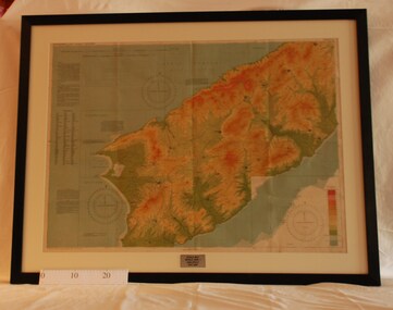
 National Vietnam Veterans Museum (NVVM)
Map
Highly detailed map of Vietnam on parchment from Fwouc Tho Province. Map is waterproof.map, peter lewis -
Moorabbin Air Museum
Map (item) - Silk Map Holland Belgium France Germany Switzerland Sheet C and D
-
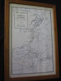 Lilydale RSL Sub Branch
Map - Framed copy of map, The canadian and American Seaboard - January to July 1942
Framed copy of mapThe Canadian and American seaboard - January to July 1942. Shows Merchant ships sunk, U boats sunk and coastal convoys organised by July 1942. -
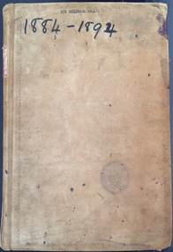 Kew Historical Society Inc
Financial record - Signature Book of the Kew Branch of the National Bank of Australasia, 1884-1894
The National Bank of Australasia was formed in 1857. It began commercial operations in Queen Street, Melbourne in 1858. The Bank’s first branch in Kew opened at 87 High Street in 1885. A second building, on the corner of Walpole and Brougham Streets, designed by Inskip & Robertson, replaced the first branch in 1888. The second building remains, albeit in a somewhat altered state. In 1977, the President of the Kew Historical Society received two historic ‘Signature Books’ from the Kew branch of the National Bank of Australia.Important and unique record of names, occupations, addresses and signatures of customers of the branch. A number of signatures belong to individuals of statewide significance. Other information such as customer occupations may be unique.Ledger containing information about customers of the National Bank of Australasia's Kew Branch for the years 1884-1894. The ledger (L8091) was purchased on 29/5/84 from Sands & McDougall, Manufacturing Stationers, 46&48 Collins Street West, Melbourne. The pages of the ledger have printed columns including: No. | Date | Name and Description (to be clearly written off by a member of the bank) | Signature | Initials of Bank Officer. As used, the pages are organised alphabetically by customer name. On each page, sequential numbering extends across the years 1884-1894. Additional pieces of advice from customers are clipped through the page over the customer's signature. Spine - "SIGNATURE BOOK" Inside front cover: Stationers labelnational bank of australasia -- kew (vic.), signature books, banks -- kew (vic.), gordon greer, mr bendixon, marshall slattery, manuscripts, financial records, bank records, national bank of australia -
 Bacchus Marsh & District Historical Society
Map, Lerderderg District Proposed Irrigation and Water Supply Trust (B) Plan Showing Proposed Works
The 1886 Irrigation Act in Victoria introduced the first legislation in Australia designed to enable the creation of a detailed scheme for agricultural irrigation. Part of the legislation saw the use of government funds for local irrigation projects. These local projects were managed by local irrigation trusts. The Lerderderg Irrigation and Water Supply Trust was formed in 1890. This map depicts the proposed area of the Trust and proposed works such as channels and weirs.Printed paper map of the proposed Lerderderg District Irrigation and Water Supply area showing proposed works. The map scale is 40 chains + 1 inch. The Lerderderg District lies within the Parishes of Korkuperrumul and Merrimu in the County of Bourke. At the top of the map above its title is the letter 'B; in capital lettering. A series of proposed channels are indicated on the map in red lines. A proposed weir site and alternative weir site are also indicated on the map. irrigation, water supply, lerderderg irrigation and water supply trust -
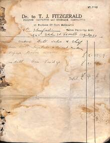 Port Melbourne Historical & Preservation Society
Financial record - Invoice, T J FITZGERALD, Plumber to Mrs STANFORD, Stokes Street, Port Melbourne, 1950
Found at 246 Stokes Street, Port Melbourne. Thomas Joseph FITZGERALD was a plumber during the 1950s and 60s. Initially working from his parents house at 12 Poolman Street, he moved to 77 Ross Street after his marriage to Dorothy Joyce STONE in 1952.Invoice of T J FITZGERALD, Plumber, 12 Poolman Street, to Mrs STANFORD at 246 Stokes Street, for various repairs, 1950.business and traders - plumbers, thomas joseph fitzgerald, mrs stanford -
Kew Historical Society Inc
Journal, Kewriosity : July 1988
Can you keep our wheels turning [Meals on Wheels] / p1. Council elections / p1. Dates for July / p2. For the nimble fingered [Bicentennial tapestry] / p2. Traffic management update / p2. Commentary / Cr Jim Tutt p3. Ways to donate to Kew Library / p3. An apology [skateboarding] / p3. Notices p4. News from the Friends [of Kew Library] / p4. Community Recreation / p4. Child care for 3-5 year olds [Belford Oaks] / p4. [Kew] Philharmonic's second concert for the year / p4. Community education [MLC] / p4. Time capsule [Kew Bicentennial Committee] / p4. Pregnancy support [Caroline Chisholm Society] / p4. Senior Citizens at HKC ready to roll [Hawthorn-Kew-Camberwell Activities Centre] / p5. Community planting of urban forest [Stradbroke Park] / p5. May celebration for two old lions [Noel Lyell, Bert Stevens] / p5. Kew Community House / Judy Price p6. Do you know about EASE? / p6. Brush up your skills at Swinburne / p6. Integration through recreation for disabled / p7. 100th birthday for St Hilary's / p7. Footy News [Kew Football Club] / p8. Learn to ski or improve your skiing skills / p8. Keeping you informed [Kew Citizens’ Advice Bureau] / p8. More wins for Kew [Citizens'] Band players / p8. Good gardening / Bruce Schroder p8.Kewriosity was a local newsletter combining Kew Council and community news. It was published between November 1983 and June 1994, replacing an earlier Kewriosity [broad] Sheet (1979-84). In producing Kewriosity, Council aimed to provide a range of interesting and informative articles covering its deliberations and decision making, together with items of general interest and importance to the Kew community and information not generally available through daily media outlets.non-fictionCan you keep our wheels turning [Meals on Wheels] / p1. Council elections / p1. Dates for July / p2. For the nimble fingered [Bicentennial tapestry] / p2. Traffic management update / p2. Commentary / Cr Jim Tutt p3. Ways to donate to Kew Library / p3. An apology [skateboarding] / p3. Notices p4. News from the Friends [of Kew Library] / p4. Community Recreation / p4. Child care for 3-5 year olds [Belford Oaks] / p4. [Kew] Philharmonic's second concert for the year / p4. Community education [MLC] / p4. Time capsule [Kew Bicentennial Committee] / p4. Pregnancy support [Caroline Chisholm Society] / p4. Senior Citizens at HKC ready to roll [Hawthorn-Kew-Camberwell Activities Centre] / p5. Community planting of urban forest [Stradbroke Park] / p5. May celebration for two old lions [Noel Lyell, Bert Stevens] / p5. Kew Community House / Judy Price p6. Do you know about EASE? / p6. Brush up your skills at Swinburne / p6. Integration through recreation for disabled / p7. 100th birthday for St Hilary's / p7. Footy News [Kew Football Club] / p8. Learn to ski or improve your skiing skills / p8. Keeping you informed [Kew Citizens’ Advice Bureau] / p8. More wins for Kew [Citizens'] Band players / p8. Good gardening / Bruce Schroder p8.publications -- city of kew (vic.), kewriosity, council newsletters, community newsletters -
Clunes Museum
Map, Township of Clunes - Parish of Clunes - County of Talbot
Map of Clunes Township in 1951Photocopy of map, (comprising a number of A4 sheets taped together) showing Lot numbers and names of landholder. Reference Gaz 1951.1480. Scale measurement is in "chains"Niltownship of clunes map, 1951 -
Kew Historical Society Inc
Journal, Kew Historical Society, Newsletter No.111, June 2015
No 111 JUNE 2015. A historian's legacy (Dorothy Rogers) / Robert Baker p1. Exhibitions, Meetings & lectures, New members, 2015 meeting calendar / p3. What's in a box? / Suzanne McWha p5. New acquisitions / Robert Baker p5. A history of community activism / Valerie Bourke p6. Kew Tram Depot / p7. Boroondara Remembers: Stories of World War 1 / p7. Daily Life in Kew: the summer of 1885-86 / Andrew Frost p8. The textiles and clothing collection / Collections Activity Group p10. Kew Tram Depot celebrates 100 years / Tony Michael p11. Membership & Donations p12.Published quarterly since 1977, the newsletters of the Kew Historical Society contain significant research by members that explore aspects of the Victorian and Australian Framework of Historical Themes. Frequently, articles on people, places and artefacts are the only source of information about an aspect of Kew, and Melbourne’s history.non-fictionNo 111 JUNE 2015. A historian's legacy (Dorothy Rogers) / Robert Baker p1. Exhibitions, Meetings & lectures, New members, 2015 meeting calendar / p3. What's in a box? / Suzanne McWha p5. New acquisitions / Robert Baker p5. A history of community activism / Valerie Bourke p6. Kew Tram Depot / p7. Boroondara Remembers: Stories of World War 1 / p7. Daily Life in Kew: the summer of 1885-86 / Andrew Frost p8. The textiles and clothing collection / Collections Activity Group p10. Kew Tram Depot celebrates 100 years / Tony Michael p11. Membership & Donations p12. kew historical society (vic.) -- periodicals., kew historical society (vic.) -- newsletters, kew historical society (vic.) -- journals -
University of Melbourne, Burnley Campus Archives
Journal, Frank Read, Enriching Victoria's Rural Resources, 1960's
primary production, horticulture -
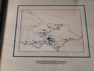 Vision Australia
Map - Object, Victorian railways map
A black and white map of Victoria showing the railway lines where mail is transported and the individual towns listed next to the dot that provides location of such. Underneath is written "Map of Victoria showing the localities beyond the suburbs of Melbourne to which library books are sent to blind members. Books are carried over the railways FREE there is no charge to the readers." Through the work of Tilly Aston, braille postage was provided free by the Victorian Railways which greatly assisted the Braille Library in reaching members who resided outside of Melbourne. This map was produced to show the extent of the work by the Victorian Association of Braille Writers and the need for reading materials across the state.Paper of Victorian railway lines mounted in framevictorian association of braille writers, marketing -
Stawell Historical Society Inc
Map, Underground Mine Workings Stawell, 1894
Plan and Elevations of mine workings 12 September 1894. J H Bate Mining Surveyor. Framed under Glassstawell, mining, plans -
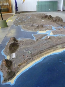 National Vietnam Veterans Museum (NVVM)
Map - Map, Relief, PHU
Raised relief map of Phuoc Tuy province. Six pieces showing land features from Long Hai hills to coast at Vung Tau baserelief map, phuoc tuy -
Glenelg Shire Council Cultural Collection
Financial record - Invoice - Campbell's Cash Stores, Aug-39
Invoice, dated 28 August 1939, from Kayser, to Campbell's Cash stores, Portland for silk hosiery -
Kew Historical Society Inc
Journal (Series) - Newsletters, Kew Historical Society, 1977-present
Kew Historical Society incInformationDate orderArchive of all newsletters published by Kew Historical Society Inc from 1977 to the presentkew historical society (vic.) -- periodicals., kew historical society (vic.) -- newsletters, kew historical society (vic.) -- journalskew historical society (vic.) -- periodicals., kew historical society (vic.) -- newsletters, kew historical society (vic.) -- journals -
University of Melbourne, Burnley Campus Archives
Journal, Australian Institute of Parks and Recreation, 1972-1975
parks, newsletters, journals -
 Montmorency/Eltham RSL Sub Branch
Map - Framed 1915 map of Sulva Bay, Gallipoli, 1915 Map of Silva Bay, Gallipoli, 1915
This map was used in the Dardenelles Campaign 1915-1916.Framed map showing the Sulva Bay area of the Gallipoli battlefield in 1915.world war one, middle east, gallipoli, 1915, map, dardenelles, sulva bay, survey department, battlefields, egypt cairo