Showing 223 items matching " city family buildings"
-
 City of Moorabbin Historical Society (Operating the Box Cottage Museum)
Newsletter, City of Moorabbin Historical Society No. 4 Vol. 7 May 1967, City of Moorabbin Historical Society Newsletter No. 4 Vol. 7 May 1967, 1967
Topic ; R K Healey family; Charles Tuck; St Matthew's Church Centenary; The Aims of the CMHS are ‘to record the history of the City, and register something of the Australian Atmosphere, which the necessary speed-up in post-world-war two (WW11) immigration has caused to be lost; to produce a magazine at regular intervals, featuring the work of pioneers and the changing Australian scene; to work constantly with a long range view towards building a hall where records and exhibits can be housed’ (1961) The Original Newsletters reflect the history and heritage of the former City of Moorabbin — derived from Mooroobin, ‘a resting place’ in the Bunurrung spoken language. In 1994, the City of Moorabbin was integrated into the Cities of Bayside, Glen Eira, Kingston and Monash. This is Newsletter No. 4 Vol. 7 of the CMHS May 1967 CMHS obtained a Kingston City Council Community Grant 2016 for the digitization and preservation of these Original CMHS Newsletters commenced in 1961 1 x L 26cm x W 21cm printed both sides CITY OF MOORABBIN HISTORICAL SOCIETY / AFFILIATED WITH THE ROYAL HISTORICAL SOCIETY OF / VICTORIA AND THE CHELTENHAM ARTS AND CRAFTS SOCIETY/ President Mrs N. Blackman… Secretary Mrs F.Neville...... / VOLUME 7 No.4 NEWSLETTER MAY 1967 city of moorabbin historical society 1961, sheehy t.a., newsletters, -
 City of Moorabbin Historical Society (Operating the Box Cottage Museum)
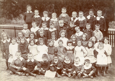
Photograph - Photograph, Black & White Cheltenham State School No. 84 1908, c1908
Stephen Charman, 1821-1906 a market gardener, donated land for the first Methodist Chapel, Cemetery and School in Charman Rd Cheltenham 1855. The enrolment was 36 pupils with Mr Frederick Meeres as Teacher. 1863 the school is called Beaumaris Common School No 84 with 70 pupils and Walter Meeres as Teacher. 1869 another 2 acres in Charman Road were granted by the Education Board and brick building built . 1872 State School 84 Beaumaris was increasing enrollments and 1878 a new brick school was built to accommodate 174 pupils and the name changed to Cheltenham State School No.84 1894 Mentone State School No.2950 amalgamated with Cheltenham SS No.84. 1910 the buildings were in disrepair, overcrowding was increasing and renovations were made 1912 with further additions in 1925 and 1937. Post WW11 extra prefabricated Classrooms were added as enrollment increased to 1038 in 1955.. Cheltenham East State School 4754 was opened as housing development spread over the City of Moorabbin . (J.Larson Sandringham HS) Pupils noted are from the early settler families - Marriott, Whelan, Cochrane1855 Stephen Charman donated land to the Methodist Church so that a School could be established to educate the children of the early settler market gardeners and farmers in the Cheltenham area . Education was valued by the general community and as well as schools they established mechanics Institutes and Libraries in Moorabbin Shire. Beaumaris West (Cheltenham) State School No. 84 was among the first schools in Melbourne.Black & White photograph of pupils in "Infants" at Cheltenham State School No.84 in 1908Handwritten ; 1908 B.McGregor, C. Marriott, E. Kilborn, R.Whelan, A. Cochrane, education, schools, horse drawn carts, toll gates brighton, motor cars 1900, steam engines, early settlers, bentleigh, parish of moorabbin, city of moorabbin, county of bourke, moorabbin roads board, shire of moorabbin, henry dendy's special survey 1841, were j.b., bent thomas, o'shannassy john, king richard, charman stephen, highett william, ormond francis, maynard dennis, market gardeners, vineyards, orchards, state schools victoria, marriott c, whelan k, cochrane a, cheltenham primary school -
 City of Moorabbin Historical Society (Operating the Box Cottage Museum)
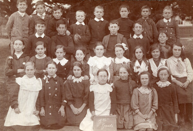
Photograph, Black & White, Cheltenham State School Grade 5 1910, c1910
1855 Stephen Charman donated land to the Methodist Church so that a School could be established to educate the children of the early settler market gardeners and farmers in the Cheltenham area . Education was valued by the general community and as well as schools they established mechanics Institutes and Libraries in Moorabbin Shire. Cheltenham State School No. 84 was among the first schools in Melbourne. Stephen Charman, 1821-1906 a market gardener, donated land for the first Methodist Chapel, Cemetery and School in Charman Rd Cheltenham 1855. The enrolment was 36 pupils with Mr Frederick Meeres as Teacher. 1863 the school is called Beaumaris Common School No 84 with 70 pupils and Walter Meeres as Teacher. 1869 another 2 acres in Charman Road were granted by the Education Board and brick building built . 1872 State School 84 Beaumaris was increasing enrollments and 1878 a new brick school was built to accommodate 174 pupils and the name changed to Cheltenham State School No.84 1894 Mentone State School No.2950 amalgamated with Cheltenham SS No.84. 1910 the buildings were in disrepair, overcrowding was increasing and renovations were made 1912 with further additions in 1925 and 1937. Post WW11 extra prefabricated Classrooms were added as enrollment increased to 1038 in 1955.. Cheltenham East State School 4754 was opened as housing development spread over the City of Moorabbin . (J.Larson Sandringham HS) The names written on the photograph show the pupils belong to many early settler families.1855 Stephen Charman donated land to the Methodist Church so that a School could be established to educate the children of the early settler market gardeners and farmers in the Cheltenham area . Education was valued by the general community and as well as schools they established mechanics Institutes and Libraries in Moorabbin Shire. Cheltenham State School No. 84 was among the first schools in Melbourne. These pupils belong to the early settler families in Moorabbin ShireBlack & White photograph of pupils in Grade 5 at Cheltenham State School No 84 c1910Front ; 1st Rodda - Millege - Lemkie, Orr / 2nd Moorhouse, McGregor, Marriott, N. Bodley, E. Howard / 3rd; K.Whelan,E.Ould, D.Kilburn, Moorhouse, Roberts, - - Tilly - Teagal,Miller, Primer. - Martin, Caulfield Back Mrs Taylorcheltenham primar school, city of moorabbin, county of bourke, moorabbin roads board, parish of moorabbin, shire of moorabbin, henry dendy's special survey 1841, were j.b., bent thomas, o'shannassy john, king richard, charman stephen, highett william, ormond francis, maynard dennis, cheltenham state school no.84, methodist chapel cheltenham, methodist school cheltenham, beaumaris west state school, meeres frederick, meeres walter, education, early settlers, cancel -
 City of Moorabbin Historical Society (Operating the Box Cottage Museum)
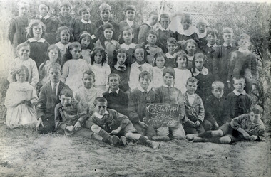
Photograph, Black & White, Cheltenham State School Grade 3 5/3/1917, 1917
Ada Pearling Pickering ( G Box ) Stephen Charman, 1821-1906 a market gardener, donated land for the first Methodist Chapel, Cemetery and School in Charman Rd Cheltenham 1855. The enrolment was 36 pupils with Mr Frederick Meeres as Teacher. 1863 the school is called Beaumaris Common School No 84 with 70 pupils and Walter Meeres as Teacher. 1869 another 2 acres in Charman Road were granted by the Education Board and brick building built . 1872 State School 84 Beaumaris was increasing enrollments and 1878 a new brick school was built to accommodate 174 pupils and the name changed to Cheltenham State School No.84 1894 Mentone State School No.2950 amalgamated with Cheltenham SS No.84. 1910 the buildings were in disrepair, overcrowding was increasing and renovations were made 1912 with further additions in 1925 and 1937. Post WW11 extra prefabricated Classrooms were added as enrollment increased to 1038 in 1955.. Cheltenham East State School 4754 was opened as housing development spread over the City of Moorabbin . (J.Larson Sandringham HS) Ada Pearling Pickering was descendant of the George Box Family who migrated in 1850,s and established market gardens in the Brighton area of Dendy's Special Survey 1841 . 1855 Stephen Charman donated land to the Methodist Church so that a School could be established to educate the children of the early settler market gardeners and farmers in the Cheltenham area . Education was valued by the general community and as well as schools they established mechanics Institutes and Libraries in Moorabbin Shire. Cheltenham State School No. 84 was among the first schools in MelbourneBlack & White photograph of pupils at Cheltenham State School No.84 Grade 3 1917 with Ada Pickering a descendant of the Box family early settlershand written Ada Pearling Pickeringbox george, box william, box elizabeth, pickering ada, city of moorabbin, county of bourke, moorabbin roads board, parish of moorabbin, shire of moorabbin, henry dendy's special survey 1841, were j.b.; bent thomas, o'shannassy john, king richard, charman stephen, highett william, ormond francis, maynard dennis, cheltenham state school no.84, methodist chapel cheltenham, methodist school cheltenham, beaumaris west state school, meeres frederick, meeres walter, education, early settlers, -
 City of Moorabbin Historical Society (Operating the Box Cottage Museum)
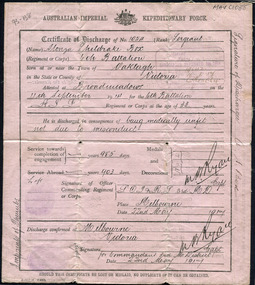
Document, Certificate of Discharge 1st AIF Alonzo Sheldrake Box 22/5/1917 2pp, 1917
Alonzo Sheldrake Box 1851- 1958 was the nephew of William and Elizabeth Box who migrated from Sussex England 1850 and established a market garden in the area of Henry Dendy's 'Special Survey 1841 Brighton, in the Parish of Moorabbin County of Bourke. Alonzo was a pavier, who laid blue stone for drains, and enlisted in 1914 to serve in Gallipoli, and France . He returned to Bentleigh 1917 and married Mary Louisa Closter 1918 . Alonzo Box was a member of the pioneering Box family who emigrated from Sussex England 1850 and established market gardens in the the Parish of Moorabbin, County of Bourke. Alonzo Box enlisted in the 1st AIF in 1914 and served in Gallipoli and France. Document, Certificate of Discharge No. 1054 Australian Imperial Expeditionary Force 1917, Alonzo Sheldrake Box Sergeant as Printed by Government Printer box george b 1808, box william, box elizabeth avis, box alonzo sheldrake, closter mary louisa, wedding dress box cottage museum, paviers, road building, world war 1 1914-1918, gallipoli, somme battles, smith j l; smith mary ann, stanley helen, smith vic, chaff cutter, horse drawn carts, early settlers, bentleigh, mckinnon, parish of moorabbin, city of moorabbin, county of bourke, moorabbin roads board, shire of moorabbin, henry dendy's special survey 1841, were j.b.; bent thomas, o'shannassy john, king richard, charman stephen, highett william, ormond francis, maynard dennis, market gardeners, vineyards, orchards -
 City of Moorabbin Historical Society (Operating the Box Cottage Museum)
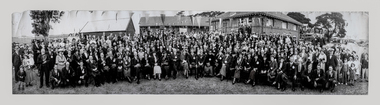
Photograph, B/W East Bentleigh SS No.2083 1925, 1925
The Common School No. 213 East Brighton 1864 - 1878 replaced the original St Stephen's Church of England School in Tucker Road. 1878-1908 the School was known as Education Department State School No. 2083 Brighton East. 1908 - 1936 the School changed it's name to Bentleigh and then from 1936 - 1993 was known as East Bentleigh. 1993 the school was closed due to low enrollments and the building was demolished and land sold . Charles J Coates, the father of Pam Thomas, attended this school.A school photograph of one of the original schools in the Bentleigh area showing a gathering of adults and children who had connection with this school either as teachers, pupils, parents or neighbours in 1925.A Black & White panoramic photograph of a group of adults and children in front of the classrooms of the East Bentleigh SS No. 2083 in 1925on back : handwritten 1925education, st stephens anglican school east brighton, education department state schools, state school number 2083, coates charles j, thomas pam, tucker road bentleigh, henry dendy special survey brighton 1841,market gardeners, dairy farmers, poultry farmers, early settlers, pioneers, tuck family bentleigh, moorabbin shire, moorabbin roads board, city of moorabbin, bent thomas, -
 City of Moorabbin Historical Society (Operating the Box Cottage Museum)
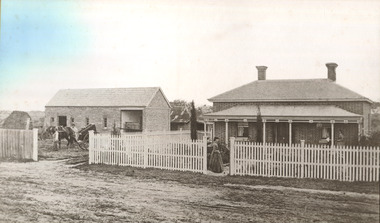
Photograph - 115 Jasper Road, Bentleigh, Allan / Grewer Estate, c. 1890's
115 Jasper Road, Bentleigh East was a market garden owned by James Allan. In 1880 the property was transferred to David Grewar (Gruar) who had married James' niece Mary Allan. In 1926 part of the land was subdivided and sold as residential blocks. The block with the house pictured remained in the family until 1969. The land now forms part of Our Lady of Sacred Heart College. The description of the land owned by David Kidd Grewer (also spelt Gruar) in 1885: Fourteen acres or thereabouts at the corner of Jasper Road and Patterson’s Road East Brighton being part of Crown Block of 5720 acres Parish of Moorabbin County of Bourke being land comprised in Certificate of Title Volume 1344 Folio 268692 on which is erected a 4 roomed brick house with 2 rooms of wood at the rear and stable and a 2 roomed weatherboard cottage valued as under: 14 acres of land less crops £629.0.0 4 roomed brick house £250.0.0 Other buildings £50.0.0 2 roomed weatherboard cottage £35.0.0 Early pioneer family of the City of Moorabbin.Black and White photo in picture framegrewar, market garden, moorabbin, bentleigh, jasper road, housing, pioneer, james allan, orchard -
 City of Moorabbin Historical Society (Operating the Box Cottage Museum)
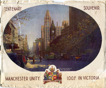
Booklet - Centenary Souvenir - Manchester Unity I.O.O.F in Victoria, IOOF Melbourne, 1934
A booklet issued by The Grand Master and Board of Directors M.U.I.O.O.F. in Victoria and compiled by W .H. Best, Grand Secretary printed in the year the City Of Melbourne began the celebration of its Centenary (1934). The booklet is about the history of Manchester Unity I.O.O.F. and the building of their Gothic building, known as the Manchester Unity Building on the corner of Collins and Swanston Streets, Melbourne. The booklet also contains many advertisements from firms who supported the compiling and publishing of the document.Many of the families living in the City of Moorabbin were members of Manchester Unity I.O.O.F. Victoria.A booklet with 40 pages printed in black and white, contents include story of the building of the Manchester Unity Building on the corner of Collins Street and Swanston Street. Advertisements of various businesses in Melbourne. Coloured Cover with a view of Collins Street.CENTENARY SOUVENIR/ PHOTO of Collins St Melbourne, / MANCHESTER UNITY / Crest of Arms/ I.O.O.F IN VICTORIAmanchester unity i.o.o.f. victoria, manchester unity building, collins street, swanston street -
 City of Moorabbin Historical Society (Operating the Box Cottage Museum)
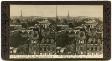
The Rose Stereograph Cards, Various pictures of European sites, 1911
This collection of Stereograph card depicts scenes from various Euopean sites and buildings. Produced by 'The Rose Stereographs. George Rose was born in Clunes, Victoria in 1861 and later worked in his father’s boot-making business in Prahran while studying photography. In 1880 he founded the Rose Stereograph Company and became famous for producing stereographs, or stereoviews, which gave the illusion of being in 3D when seen through a hand-held viewer.Collection of one of the pioneer families of City of Moorabbin.11 Stereographic Cards - manufactured by The Rose Sterographics - Black and whiteDescription of each card on the bottomeurope, paris, church of mary magdalene, the louvre, cathedral of notre dame, palace of justice, palace of beautiful arts, champs elysees, boulevard du nord, jules anspach fountain, brussels belgium, cathedral of st gudule, brussels, moorabbin, stereograph cards -
City of Moorabbin Historical Society (Operating the Box Cottage Museum)
Book - The Living Harvest - A history of St. Peter's Parish, East Bentleigh, by W. T. Dobson, 1974
The first building that was erected in the Parish of St Peter's was a little wooden school house, built by local market gardeners in February 1865. The school was demolished and a brick school building was erected and opened in1903. St Peter's School, East Bentleigh was erected by the many Irish Market Gardeners of Moorrabin in 1865 and was integral to the education, spiritual well being and social life of the early settlers.A book on the history of St Peter's Parish, Centre Road, East Bentleigh, with pictures. 57 pages. Contains local history, history of early pioneer families, St Peter's School and the church.early settlers, parish of moorabbin, city of moorabbin, county of bourke, shire of moorabbin, market gardeners, center road, irish settlers, east bentleigh, st peter's church east bentleigh, religion, catholic -
 Bendigo Historical Society Inc.
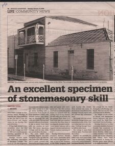
Document - BARBARA MAMOUNEY COLLECTION: NEWSPAPER ARTICLE ON SPECIMEN COTTAGE
Newspaper feature from Bendigo Advertiser Tues January 12 2016 and image of Specimen Cottage before restoration in 1970s It was built by stonemason James Brierley for his family Is now the front of house and display centre for The Bendigo Historical Society and is arguably the oldest building in the city with 1856 shown above the front door Near the corner of Hargreaves and Mundy St The building has two parts The 1856 section is single storey with front façade of locally sourced sandstone rubble with dressed quoins and dressings to openings, side walls are of rubble the rear and interior walls are of red brick a central front door a window on either side The roof which was probably hipped, was later joined to the next wall of the 1861 section and is partly covered with Morewood and Rogers metal tiles with partly corrugated iron The 1861 section was built to match the earlier one Across the first floor of the 1861 section is an elegantly detailed cantilevered timber balcony with a hived concave roof and two French windows opening onto it Bendigo Historical Society members Barbara Poustie and Carol Holsworth have led tours of the cottage as part of the 'Summer in the parks' program A plaque on the corner of Hargreaves and Mundy indicates that there once stood the Royal Princess Hotel, also built by Brierley, Bendigo Historical Society members have continued research on the Brierley familyhistory, australian, bendigo, architecture, specimen cottage royal princess hotel built by james brierly in 1856 barbara proustie carol holsworth -
 Bendigo Historical Society Inc.
Newspaper - JENNY FOLEY COLLECTION: IMPOSING
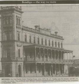
Bendigo Advertiser ''The way we were'' from 2000. Imposing: the City Family Hotel, Charing Cross, circa 1875. Mr. J.C. Hadley was the lessee, and Mr. J.B. Loridan the owner. The architects were Messrs Vahland and Getzschmann, and the building was completed in November 1872. the clip is in a folder.newspaper, bendigo advertiser, the way we were -
 Bendigo Historical Society Inc.
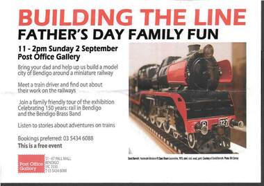
Document - RAILWAYS COLLECTION: POST OFFICE GALLERY ADVERT FOR THE BUILDING OF A MODEL RAILWAY
Railways Collection -Post Office Gallery Advert for the building of a model railway ''Building the line -Father's Day Family fun'' 2.9.2012 at the Post Office Gallery. The advert was for the building of a model city of Bendigo around a miniature railway. The photo shows a colour photo of a model of Loco R 727 1973 by David Bemoth.photograph -
 Bendigo Historical Society Inc.
Document - MINING IN BENDIGO COLLECTION: BENDIGO GOLD FIELDS, 1968
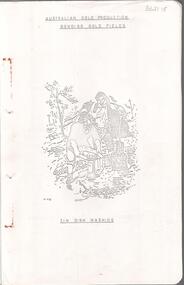
Typed copy of the Bendigo Gold Fields , collected and arranged by V. R. Dwyer, 1968. On front cover: Australian Gold Production Bendigo Gold Field. Image of tin dish washing. Cover has an image of two people tin dish washing. Notes include a brief history of gold in Australia, Bendigo Goldfield yields, Bendigo Gold Nuggets, Victorian Nuggets, gold prices, yield for the years 1851 to 1890, lines of reef, mine shafts and depth, location, public buildings and organisations and mines listed for each reef. Typed copy of this document is held in Folder 130, number 3621.18.cottage, miners, mining in bendigo, bendigo gold fields index, v r dwyer, strzelecki, edward hargreaves, thomas hancock, henry frenchman, wittscheibe, ballerstedt, fortuna villa, george lansell, the rocks, victoria nugget, dascombe nugget, welcome stranger, welcome nugget, canadian nugget, sarah sands, lady hotham, maryborough, heron nugget, blanche barkley, vicount canterbury, precious nugget, poseidon, gold prices, gold yield 1851 - 1890, location of shafts, mechanics institute, old masonic hall, court, st killians, forrest st methodist church, hospital, baptist church, bendigo gas company, st andrews presbyterian church, bendigo benevolent home, railway, st marys church of england, bendigo m p building society, st pausl church of england, high school, city family hotel, fire brigade, b u f s dispensary, synagogue, beehive store, school of mines, bendigo miners association, st marys convent, dr backhaus, st mathews long gully, salvation army, post office, art gallery, sacred heart cathedral, eaglehawk town hall -
 Bendigo Historical Society Inc.
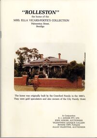
Document - 'ROLLESTON' AUCTION CATALOGUE
'Rolleston' the home of the Mrs. Ella Vicars-Foote's Collection Palmerston Street, Bendigo. Order of Sale. In Conjunction: E. J. Ainger Pty. Ltd. John Ainger, Auctioneer, Valentine's Antique Gallery (formerly Cliff's Antiques) Allan Valentine Auctioneer. Home originally built by Crawford Family in the 1880's - Gold Speculators and owners of the City Family Hotel. March 1985. Printed by J. J. & D. V. Mulqueen, Kangaroo Flat.place, building, residential, rolleston, mrs ella vicars-foote, e j ainger pty ltd, john ainger, valentines antique gallery, cliff's antiques, allan valentine, crawford family, city family hotel, j j & d v mulqueen -
 Bendigo Historical Society Inc.
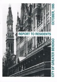
Book - BOOKLET: ''REPORT TO RESIDENTS CITY OF GREATER BENDIGO, OCTOBER 1995''
Front cover is a photo of The Shamrock Hotel. 52 paged booklet - ''Report to Residents - City of Greater Bendigo, October 1995''. Table of Contents; Commissioners; Chief Executive Officer; Council meetings; Office location and hours; ''One Telephone Number''; Committees; Ward boundaries; Elections; Customer services; Rural services; Economic development; Bendigo Tourism Board; Bendigo Trust; Events Bendigo; Capital works 1995/96; Major projects; Discovery; Bendigo Regional Arts Centre; local laws; Fire prevention; Aged and disability services; Children and family services; Environmental health; Recreation and leisure; Parks and gardens; Planning and building; Waste management; Library services; Bendigo Leisureland; Rates; Budget for 1995/96; Index. Contains some photographs and map of proposed 7 internal Wards for the City of Greater Bendigo.Richard Cambridge Printers Bendigo.bendigo, council, report, maxine crouch, maurie sharkey, perer ross-edwards, peter seamer, hadley sides, richard morriss, bernard smith, annie galvin child care centre, bendigo regional art centre, rosalind park, budget 1995/96. bendigo health care services. -
 Bendigo Historical Society Inc.
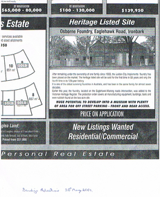
Newspaper - LONG GULLY HISTORY GROUP COLLECTION: OSBORNE FOUNDRY EAGLEHAWK ROAD IRONBARK
Copy of an advertisement from the Bendigo Advertiser 30 May 2001. Advertisement is for the Osborne Foundry, Eaglehawk Road, Ironbark. A photo shows the building with Golden City Implement painted on the front. The foundry had been in the same family for almost seven decades and is now listed for sale. Price on Application. Written underneath is: Bendigo Advertiser 30th May 2001.bendigo, history, long gully history group, the long gully history group - osborne foundry eaglehawk road ironbark, golden city implements, victorian heritage register, bendigo advertiser 30/5/2001 -
 Bendigo Historical Society Inc.
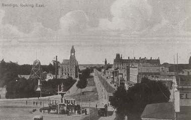
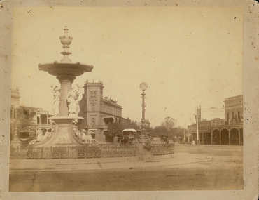
Photograph - BENDIGO LOOKING EAST ALONG PALL MALL, c1915
Black and white photograph taken from the City Family Hotel Tower, looking along Pall Mall towards White Hills, Showing Alexandra fountain, toast rack tram, 1903 tram, Hustler's Royal Reserve Mine, Post Office, Law Courts behind, tram track, School of Mines tower, Shamrock Hotel and other businesses, The Beehive, Pikes Building and verandah of building in foreground. Inscriptions: 'Bendigo, looking East' in TLH corner. History: photographic copy in black and white of a colour tinted postcard, printed c1915. Copied c1970place, streetscape, pall mall, photograph, photography, bendigo, alexandra fountain, toast rack tram, bendigo law courts, bendigo post office, bendigo school of mines, beehive building, hustler's royal reserve mine -
 Bendigo Historical Society Inc.
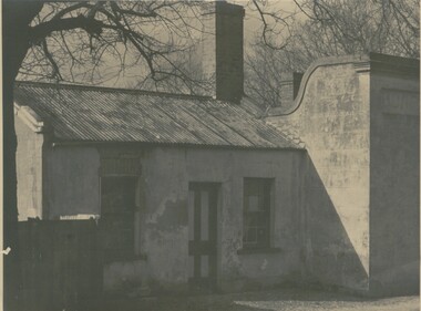
Photograph - COTTAGE, 1930 ?
black and white photograph: cottage, galvanised iron roof, stone construction. Central door, sash windows, 2 chimneys. Right of photo word ' Boar' Picture taken late Autumn. Handwritten in ink ' City Hotel, Barnard St., Cnr. Mercy Street ' Written in pencil ' this is the Mercy Street entrance, demolished in the 1950's'. Occupiers ' Mrs. W. Moore, board and residence later - Mrs Burns confectionary, shop about 1914. Later - Nielson Family 1920's - 1930's to ? ( Will Nielson was night worker at Cohn's Brewery )buildings, residential, cottage -
 Bendigo Historical Society Inc.
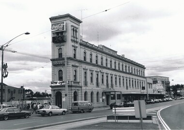
Photograph - BENDIGO HOTEL COLLECTION: CITY FAMILY HOTEL: BENDIGO, 1995 ?
... BUILDINGS Hotel city family Peter Hyett Black and white photograph ...Black and white photograph: City Family Hotel, 1 High Street, Bendigo. 3 storey rendered building with square tower, motor vehicles at front. In image ' City Family Hotel' on parapet. A7 on back in black lead.Peter Hyettbuildings, hotel, city family -
 Bendigo Historical Society Inc.
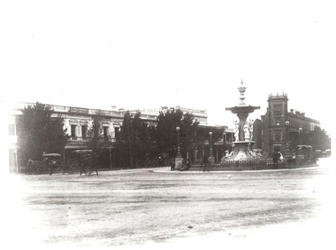
Photograph - ALEXANDRA FOUNTAIN, 1890's
black and white copy: Alexandra Fountain, City Family Hotel, Holdsworth Chemist, shops along Pall Mall, horse drawn cabs, View Point. 'View Point/Alexander (sic) Fountain '537' in white bottom left.place, building, alexandra fountain -
 Bendigo Historical Society Inc.
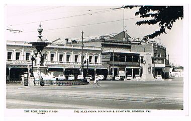
Postcard - ALEXANDRA FOUNTAIN AND CENOTAPH BENDIGO
Postcard, black and white. The Alexandra fountain and cenotaph, Charing Cross, Bendigo. Image shows Alexandra Fountain on LH side, City Family Hotel on LH side behind fountain. Cenotaph on RH side. On bottom ' The Rose Series, P 1636, The Alexandra Fountain and Cenotaph, Bendigo, Vic.'The Rose Seriesbendigo, buildings, alexandra fountain, bendigo, charing cross, cenotaph, alexandra fountain -
 Bendigo Historical Society Inc.
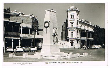
Postcard - THE CENOTAPH, CHARING CROSS BENDIGO
Postcard, black and white. Image shows cenotaph in centre of image, City Family Hotel on RH side. On bottom ' The Rose Series P2938, The Cenotaph, Charing Cross, Bendigo, Vic.'The Rose Seriesbendigo, buildings, cenotaph, bendigo, charing cross, cenotaph, city family hotel. -
 Bendigo Historical Society Inc.
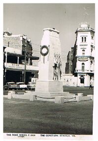
Postcard - CENOTAPH, BENDIGO
black and white photo: Cenotaph, Charing Cross, Bendigo. City Family on Rh side, Star Building Society on LH side. On bottom ' The Rose Series P2959, The Cenotaph, Bendigo, Vic. 'buildings, organisation, rsl cenotaph, cenotaph, bendigo, city family hotel. -
 Bendigo Historical Society Inc.
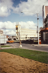
Photograph - CHARING CROSS, BENDGIO, c1980
Colour photograph: Charing Cross depicting City Family Hotel. Taken from dividing strip in View Street. Woman with shopping bag crossing View Street. Front of Cahils Chambers on rightplace, building, commercial -
 Bendigo Historical Society Inc.
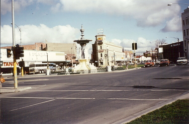
Photograph - CHARING CROSS, BENDIGO, c1980
Colour photograph: View of Charing Cross from Pall Mall on Rosalind Park side. Fountain Plaza on left with Tandy's store, City Family Hotel and Alexandra Fountain in center, National Mutual and Cahil Chambers on right. Physical condition: loose colour photo.buildings, commercial, charing cross -
 Bendigo Historical Society Inc.
Photograph - ALEXANDRA FOUNTAIN: BENDIGO, 1882
sepia photo: Alexandra Fountain, looking south towards City Family Hotel. On back 'Alexandra Fountain about 1882. Taken by Harris of Axedale. Taken in summer, note white cover on cab 'Harris of Axedaleplace, building, alexandra fountain -
 Bendigo Historical Society Inc.
Photograph - W. G. DAHL PHOTO SERIES
Photograph captioned 'Golden Square Fire Brigade Dahlia Float at Easter Fair', is one of nine sepia mounted photographs pertaining to early 20th century Bendigo donated to BHS by the Essendon Op Shop. Uncle Son caption and tick possibly relates to W G Dahl. Float mounted upon a hand drawn fire brigade hose & reel cart has two uniformed Fire-men standing beside the cart, along with three kneeling men wearing ties, vests and suits. Float covered in dahlia flowers has sign reading 'Erected by the Committee of the Victorian Gold Jubilee Exhibition Melb 1901-2 in Commemoration of the Discovery of Gold in Bendigo'. Moulded images in white featuring a kneeling boy panning for gold beside a standing young girl in long dress are prominently displayed upon the top portion of the flower covered float. The float stands in Charring Cross in front of the now demolished Horse Bazaar once located between the Lyric Theatre and the City Family Hotel. Ornate brickwork of the building follows the roof-line either side of embossed 'Established 1853'. Two matching arches are featured on front of building. Horse Bazar is embossed in large capital letters above main entrance arch, with Nicholls & Hill above the other. Embossed letters below read succeeded to L Macpherson & Co & F Hill. A small arched window within walled arch matches entrance arch. A notice board mounted on building front reads, Office of the Australian Alliance Assurance Company , Fire Life Guaranteed. Sandhurst agents ,L Macpherson Sternberg & Son.bendigo, fire brigade, golden square -
Port Melbourne Historical & Preservation Society
Photograph - Irving children celebrate first run of the boat train, 1936
PORT PHILLIP CITY COLLECTION Black and white photograph ; "Irving children celebrate first run of the boat train 1936" on the back of the January page of the PMHPS 1999 calendar. Information about the Boat Train printed beside photograph. Station Pier building visible above the train, which is on its first runtransport - railways, transport - shipping, piers and wharves - station pier, families, celebrations fetes and exhibitions, laura irving mcgill -
 Port Melbourne Historical & Preservation Society
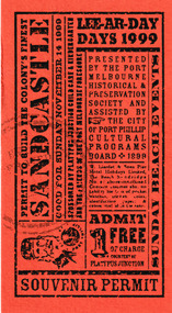
Souvenir, Pat Grainger, Souvenir Ticket Lee-Ar-Day Days 1999, November 1999
Wilbraham LIARDET & his family arrived on what was to be known as Sandridge Beach in November 1839. The Lee-Ar-Day Days festival was a weekend program of events celebrating this centenary with activities such as sandcastle building featured on this ticket.Dark orange card with black print.Permit to build a sandcastle.celebrations - centenaries, wilbraham frederick evelyn liardet, liardet family, city of port phillip cultural programs board