Showing 231 items
matching land register
-
 Federation University Historical Collection
Booklet, Ballarat School of Mines Register of Attendances for Land Surveying, 1909
... Ballarat School of Mines Register of Attendances for Land... Ballarat School of Mines Register of Attendances for Land Surveying ...The Ballarat School of Mines is a predecessor institution of Federation University Australia. A slim, green pastel, hard cover volume with dark blue spine. Two full-width pages for entering names of those enrolled.ballarat school of mines, a.d. gilchrist, land surveying -
 Flagstaff Hill Maritime Museum and Village
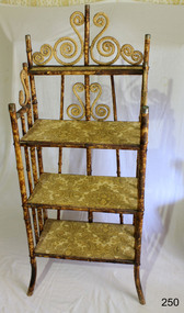
Furniture - Shelves, A. Englander & Searle, Late 19th Century (1898)
This music stand set of shelves is one of many 19th century items of furniture, linen and crockery donated to Flagstaff Hill Maritime Village by, Vera and Aurelin Giles. The items are associated with the Giles Family and are known as the “Giles Collection”. Many of the items of furniture, linen and crockery in the Lighthouse Keeper’s Cottage were donated by Vera and Aurelin Giles and mostly came from the simple home of Vera’s parents-in-law, Henry Giles and his wife Mary Jane (nee Freckleton) whose photos are in the parlour. They married in 1880. Henry, born at Tower Hill in 1858, was a labourer on the construction of the Breakwater before leaving in 1895 to build bridges in N.S.W. for about seven years. Mary Jane was born in 1860 at Cooramook. She attended Mailor’s Flat State School where she was also a student teacher before, as family legend has it, she became a governess at “Injemiara” where her grandfather, Francis Freckleton, once owned land. Henry and Mary’s family of six, some of whom were born at Mailor’s Flat and later children at Wangoom, lived with their parents at Wangoom and Purnim west, where Henry died in 1933 and Mary Jane in 1940. THE SHELVES During the years 1869-1935 there were well over 250 registered bamboo furniture producers in Britain. The earliest recorded firm was Hubert Bill of 14 Little Camden St, London N.W., who claimed to have been established in (1869 the first bamboo furniture maker), while Daniel Jacobs & Sons of Hackney Road, London, were still in business in 1915, after 45 years of production. Design, quality, price and methods of construction were fairly consistent throughout the whole period, but it was the imaginative and often eccentric choice of subject matter that marked the differentiation between the various firms. While most produced standard tables, stands and fire-screens, the more adventurous offered for sale items such as Corner shelve units, charcoal barbecue grills and musical tea tables. Shelves were often covered with embossed leather paper designs, at first imported from Japan and then later produced in England. Some firms incorporated the knobbly roots of the bamboo stems into their designs, generally to form feet. Occasionally handles to drawers and cupboards were made with these roots although they were more commonly carved as imitations. Handles were mostly of cheap metal or brass. The ends of the bamboo canes were capped with stamped metal or turned bone, ivory or wooden discs. Methods of construction fell into three categories. First and most common is that of pegging. Bamboo stems being hollow, thick dowels can easily be glued into the joints. Some firms farmed out this work of `plugging' the ends of the canes to part-time workers at home. The second method, that of pinning, was far less satisfactory as bamboo tends to split lengthwise and therefore the jointed pieces eventually disintegrated. The most efficient method was that patented in 1888 (patent No 2383) by the firm of W. F. Needham in Birmingham. It consisted of metal shoes and covers for all joints which were made by wrapping a metal strip around the stems and soldering the overlapping ends. Some joints were further strengthened by a small pin or screw. Needham was by far the largest and most successful manufacturer and their individual and superior method of construction undoubtedly gained them their reputation. A. Englander & Searle of 34 Gt Eastern St and 31 Mare St, Hackney, London, were a firm particularly concerned with methods of construction. Although they seem to have entered the bamboo furniture market at a comparatively late date, about 1898, they produced inexpensive bamboo, aimed particularly at the export trade. The company stated in their catalogue that bamboo furniture “can be exported in one piece or it can be exported in pieces and put together again. The fixing up is much facilitated by a system of marking and numbering. Further, no glue is required for putting together as the screw system only is applied”. This method of construction best fits the Etagere in the Flagstaff collection and it is believed to have been made by A Englander & Searle, exported in a knock down form to Australia, purchased in kit form from a dealer hear and put together by the owner. The Etagere is a significant item as it highlight furniture fashion of the late Victorian era. This item was highly sort after in its time and although mass produced, not many examples remain, so this example is a valuable addition to the Flagstaff collection. It is believed that the construction method used is by a notable and respected maker of bamboo furniture and that its production was aimed at the export market and probably came to Australia in kit form.Bamboo shelves: decorative free standing Etagere comprising three large shelves and one small shelf. Shelves are made of wood used to store either orange or bacon boxes (as there are no knots in the wood, imported from South America and cheap to recycle). Shelves are covered with embossed leather paper. Frame is made from tortoise shell bamboo (brown lacquer applied to simulate tortoise shell appearance). Ends of bamboo canes are covered with metal shoes and fixed with a pin. Other bamboo joints are fixed with round head steel screws. This item is part of the Giles Collection.Noneflagstaff hill, warrnambool, shipwrecked-coast, flagstaff-hill, flagstaff-hill-maritime-museum, maritime-museum, shipwreck-coast, flagstaff-hill-maritime-village, bamboo shelves, bamboo etagere, victorian furniture, furniture, bamboo furniture, embossed leather paper, simulated bamboo, tortise shell, a englander & searle, giles collection, henry giles, tower hill, cooramook, warrnambool breakwater, mailor’s flat, wangoom, 19th century furniture -
 Flagstaff Hill Maritime Museum and Village
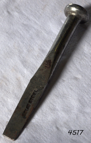
Tool - Caulking Tool, Ward & Payne Ltd, Late 19th century
Caulking is the traditional technique used on wooden vessels built with butted or clinker-built planks to fill the gaps between these planks while still allowing the wood to flex and move. This involved driving the irons, hammered in with the mallet, deep into the seams to open them up. After this, spun yarn, oakum (hemp) or cotton was driven deep into the gaps. The hemp or cotton was soaked in creosote or pine tar to make the joins watertight. Caulking also played a structural role in tightening up the hull or deck by reducing the longitudinal movement of the neighbouring planks. The subject item was made by Ward & Payne of the Limbrick Works at Hillsborough, Sheffield England manufacturers of hand-forged tools. Their trademark registered in 1850 was a Letter "W" & "P" stamped into the steel. The firm was established by David Ward (1767-1822) in 1803 the company became David Ward & Sons, in 1837 after Ward's son Edward joined the firm. In 1845 Henry Payne the founder's son-in-law became a partner but died in 1850 after which the company reverted to the Ward family. The business then concentrated on making carving tools, chisels and gouges. In 1882 David Ward's grandson David Ward Jr. (1835-1889) purchased land and built a factory at Sheffield North known as the "Limerick Wheel". For a time Wards operated from both 106-114 West Street Sheffield and at Limbrick Road, Hillsborough on the river Loxley. By 1911 they had expanded into making spades, forks, sheep shears and many other types of edged tools including drills and wood planes. In 1967 Wilkinson Sword purchased all the company's share capital and continued to sell Ward & Payne tools until 1970 when a fire burned the factory down and housing development was built on the site. The subject item is significant as it gives a snapshot of the technological development of sailing ships and their operation before steam-powered vessels took over around the world. Tools such as the subject item demonstrate the traditional craftsmanship and skill of the shipwright and the aesthetic quality of the timber ships designs of the time. Caulking tool with square end"WARD Sheffield"flagstaff hill, warrnambool, flagstaff hill maritime museum, shipwreck coast, flagstaff hill maritime village, james s steele, caulking iron, caulking tool, shipwright tools, ward & payne sheffield, forged tools -
 Flagstaff Hill Maritime Museum and Village
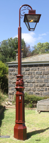
Functional object - Lamp Light, late 19th - early-20th century
This gas lamp light and stand came from the original manufacturer in Melbourne. Gas street lights such as this one were used in Melbourne from the mid-19th century. The lights enabled safer after-dark travel for pedestrians and vehicles and were a deterrent to crime. A lamp lighter was employed to keep the lamps lit, sometimes with little success due to weather conditions and the pranks of youths. WARRNAMBOOL Gasworks In Warrnambool prior to 1874 there were about twenty rare, individually lit street lights in Warrnambool, each with its own supply of kerosene. These lamps were in the central business area of Timor, Koroit and Liebig Streets. The Warrnambool Gas Company Ltd. was registered as an incorporated company in 1873. It was a private, locally owned business. It was located at 209-215 Merri Street, Warrnambool, on the land, which is just west of the later-built railway station. The first managers of the Gas Company lived in a substantial stone house on site, but later the managers lived in a residence in Henna Street between Merri and Timor Streets. The original home, which still stands, became a residence for the Railway Station Master from about 1890. In August 1874 the construction of the gasworks was complete and at the end of that month gas was supplied to all of the existing lamps in Warrnambool for the first time. The Warrnambool Gas Company wound up in 1880-1881 and was purchased by the Warrnambool Borough Council with money raised by a loan – the Borough’s first ‘loan transaction’. The Council established a piped network to supply gas to other street connections. The gasworks were privatised and upgraded in 1952. In 1972 the town supply was converted to liquid petroleum gas and by the early 1980s the gasworks were closed down. In 1986 Warrnambool was supplied with natural gas from a site near Port Campbell. The Warrnambool gasworks supplied all street and shop lighting and most domestic lighting until 1923 when electricity was available for lighting. Bromfield Street in Warrnambool was named after the director of the gasworks, James Astley Bromfield (1823-1903). He arrived in Warrnambool from Worcestershire, England, in 1852 and was very active in the local council and community. Cockman Street was named after the first secretary of the gasworks in 1874, Walter Cockman (c.1821-1892). He was a Mayor and businessman. The second Manager, Luther Rodgers, worked for the gas company for about twenty years and both Rodger Place and Rodgers Road in Warrnambool have been named after him. LAMP LIGHTS IN MELBOURNE In the 1820s Melbourne's innkeepers were legally required to have a lamp light outside their premises from sunset to sunrise. This was the first instance of street lamps being used in Melbourne. In 1847 the first oil lamp was used in the city. In 1849 a gas lamp was installed on the Swanston Street Bridge and much of the city had oil lamps installed by then. In August 1857 the installation of street gas lamps began in Melbourne. They were welcomed for the much brighter illumination they gave. By 1860 there were 414 lamp pillars. The phrase was quoted often - "A light was as good as a policeman". The first gas burners used for street lighting were called 'fishtail' gas burners. These were replaced in the early 1900s by gas mantles. The City of Melbourne Gas Coke Company was formed in 1850 but due to the Gold Rush the manufacture and distribution of the gas supply was delayed until January 1856. By the 1890s the gas supplying the lights was supplied by three companies in Melbourne. In 1879 a football match was played at the MCG under electric lighting and gradually electric arc lights were installed inside and outside buildings in the city. Lamp lights such as the one in Flagstaff Hill’s collection were no longer needed. (References: John Lindsay re Lamp Light history 2019-01-29, Former Warrnambool Gas Company Limited, Victorian Heritage Database Report, Heritage Number 149746 https://vhd.heritagecouncil.vic.gov.au/places/149746/download-report ) The lamp light is representative of the lamps used in Melbourne from the mid-nineteenth century to light the streets at night and make Melbourne a safer city. The lamp is also representative of the gas street lighting in Warrnambool from the mid-1870s-1920s.Lamp light or gas light. Street light, one of the last gas street lights removed from Melbourne. (Reconditioned by Friends of Flagstaff Hill, 2013)flagstaff hill, warrnambool, shipwrecked coast, flagstaff hill maritime museum, maritime museum, shipwreck coast, flagstaff hill maritime village, great ocean road, lamp light, gas light, gas lamp, street lamp, street light, gas street light, melbourne street lighting, warrnambool street lighting, melbourne gas street light, warrnambool gas company, warrnambool gasworks, james bromfield, walter cockman, luther rodgers, city of melbourne gas coke company -
 Kiewa Valley Historical Society
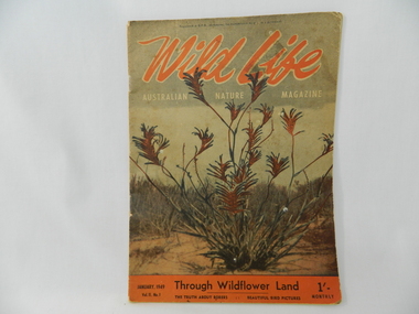
Magazine - Nature, Joseph Swanson Wilkinson, Wild Life Australian Nature Magazine, January 1949
This magazine was part of the Bogong School's library and represents an important aspect of the school's curriculum.Bogong School was noted for having a great interest in nature and conservation. 48 page soft covered magazine. Cover with limited colour including orange, black, white and brown with green. Inside pages in black, brown and grey pictures with black print on off white pages. Page 41 is in cartoon form. 'Registered at G.P.O. Melbourne for transmission by post as a periodical'. written in black in tiny print across the top. 1st line: 'Wild Life' in orange with white outline. 2nd line: 'Australian Nature Magazine' in white underneath title. All across top. 3rd written line: 'January, 1949 Through Wildflower Land 1/-' underneath picture of Kangaroo Paw. in black Underneath this writing follows: 4th line: 'Vol.11 No. 1 The Truth About Borers : : Beautiful Bird Pictures' in black Underneath 1/- is 'Monthly' Background behind black writing is orange same as title.bogong primary school. bogong. wild life. nature. -
 Bendigo Military Museum
photograph - Cartographic Squadron Production – Army Survey Regiment, Fortuna, c1980
This collection of 12 photos was most likely taken in 1980. The photos were most likely taken in Cartographic Squadron’s Ante Room, the Attic and small offices on the top floor of Fortuna Villa. The computer based Editwriter typesetting system was introduced in 1975 as a replacement to the aging Fotosetter machine. It was operated by a specialised technician, who generated a large variety of map type styles and sizes quickly and reliably, as well as text panels. CPL Richards performed this task for several years and in photo .1P and .2P is reading off a type order next to the computer monitor. Output on Copy proof adhesive backed stripping type film replaced messy wax and spray adhesives in 1978. The Editwriter capability supported all RASvy units and contractor type setting requirements. Scribing was the cartographic process of drafting features such as drainage, relief, vegetation, roads and culture on specially coated map reproduction material. The cartographic technician scribed out the map feature such as a contour to a specified line width on the map sheet, using a tool affixed with a sapphire tipped cutter. The quality control edit (Proving) stage of map production was the first opportunity to inspect a proof of the map independently and systematically. Proving tasks were carried out by technicians conversant of the map product specification and task requirement, however, was not involved in its production. Corrections were identified, marked up and sent to back to the correcting section or contractors. Terrain Embossing was a manual map production technique to produce hill shading on medium to small scale graphics and air charts. SPR John Martin is seen in photos .8P to.10P using a fine embossing metal stylus to push down on the drainage impression on a thin malleable opaque plastic material (AK Poligraphy). Ridge lines were then pushed down using the contour impression as a guide, on the opposing side of the AK Poligraphy to create a 3D plastic model terrain effect. The map impression was sprayed with white paint and photographed to create a contone tone hill shade. SPR Gina (Coore) Neilson is seen in photo .11P washing a contone positive of a land mass in a solution. The contone components were registered to the map sheet, as shown in photo .12P and masked using an air brush and a halftone negative was then created. The terrain embossing method of producing hill shading was more efficient to produce than previous specialised artistic methods such pencil/eraser and air brush. Furthermore, a more consistent enhancement of terrain on charts was achieved between technicians.This is a set of 12 photographs of Cartographic Squadron performing four map production tasks at the Army Survey Regiment, Fortuna, Bendigo c1980. The first ten photographs were on 35mm negative film and were scanned at 96 dpi. Photos .11P and .12P were on photographic paper and scanned at 300 dpi. They are part of the Army Survey Regiment’s Collection. .1) - Photo, black & white, c1980, Editwriter typesetter, CPL Paul Richards. .2) - Photo, black & white, c1980, Editwriter typesetter, CPL Paul Richards. .3) - Photo, black & white, c1980, Scribing contours on a RAAF Chart, SPR Megan (McBurney) Reynolds. .4) - Photo, black & white, c1980, Scribing contours on a RAAF Chart, SPR Megan (McBurney) Reynolds. .5) - Photo, black & white, c1980, Scribing contours on a RAAF Chart, SPR Rod Skidmore. .6) - Photo, black & white, c1980, Scribing contours on a RAAF Chart, SPR Rod Skidmore. .7) - Photo, black & white, c1980, Formal quality control edit (Proving), CPL Ian Belmont. .8) - Photo, black & white, c1980, Hill Shade Terrain Embossing, SPR John Martin. .9) - Photo, black & white, c1980, Hill Shade Terrain Embossing, SPR John Martin. .10) - Photo, black & white, c1980, Hill Shade Terrain Embossing, SPR John Martin. .11) - Photo, black & white, c1980, Hill Shade Terrain Embossing, SPR Gina (Coore) Neilson. .12) - Photo, black & white, c1980, Hill Shade Terrain Embossing, unidentified..1P to .10P No personnel are identified. .11P and .12P annotated ‘Terrain Embossing’royal australian survey corps, rasvy, army survey regiment, army svy regt, fortuna, asr, carto -
 Upper Yarra Museum
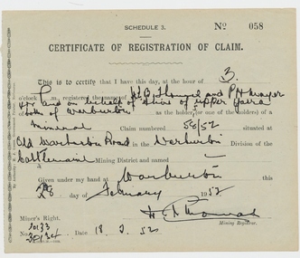
Document, Circa 1952
A person wanting to dig for Gold or any other precious metal were required to register a claim on the land to be mined, the claim had to be measured & pegged to be specific as to its size and shape.Certificate Miners Claim No 058gold, document, certificate, miners claim -
 Kiewa Valley Historical Society
Book - Mt Beauty Voters' Roll, Shire of Bright - Voters' Roll 1979 - Mt Beauty Riding, 1979
Electoral roles list people who are registered and eligible to vote at federal, state, territory and local government elections and referenda. Prior to 1990 the rolls list voters in alphabetical order by surname and first names within each Sub-division of an electoral Division of each State or Territory. The roll is useful and interesting for family historians and the study of demographics.Electoral rolls help to locate the residential address of a person in a particular year or over a period of years. They can be used as a substitute for census records for family historians and the history of a particular place, in this case Mt Beauty. Alex McCullough was a resident of Mt Beauty and Councillor in the Bright Shire. 40 pages of firm blue paper with black typed print on one side only in 'landscape' format. Held by three staples. Each page has columns - numbered 1 to 656; Surnames in alphabetical order; Given names; Occupation; Includes L = 'land'; Address followed by Lot number in the Parish of WermatongOn the cover, top right hand corner "Cr McCullough"shire of bright; mt beauty riding; voters roll; parish of wermatong; alex mccullough -
 Kiewa Valley Historical Society
Book - Kiewa Voters' Roll, Shire of Bright - Voters' Roll 1979 - Kiewa Riding, 1979
Electoral rolls list people who are registered and eligible to vote at federal, state, territory & local government elections and referenda. Prior to 1990 the rolls list voters in alphabetical order by surnames & first names within each Sub division of an electoral division of each State or Territory. The roll is useful & interesting for family historians and the study of demographics. Alex McCullough lived in the Shire of Bright and was on its Council. Electoral roles help to locate the residential address of a person in a particular year or over a period of years. They can be used as a substitute for census records for family historians and the history of a particular place in this case the Kiewa Valley - Tawonga and Tawonga South.Approx. 60 pages of firm yellow paper with black typed print on one side only in 'landscape' format. Held by three staples. Each page has column - numbered 1 to 943; Surnames in alphabetical order; Given names; Occupation; includes L (=land). Address followed by Lot number and parish. Includes Tawonga and Tawonga SouthOn the cover on the right hand side handwritten and difficult to read - "Jack? / Indi / Benambra / Nth Eastern / Division? of Dawson / 123 Victoria Rd. / Melbourne 3000"shire of bright; kiewa riding; voters roll; alex mccullough; tawonga; tawonga south -
 Port of Echuca
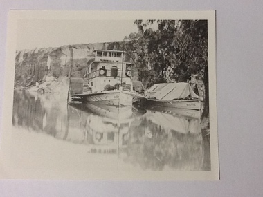
Black and white photograph, Approx.1980
Details of P. S. Queen: construction: composite 16 h.p. Registered tonnage: gross 128, net 92. Dimensions:L.103.3 ft B.18.5ft. D 5.7ft. Port and date of registry:Adelaide, 1880, no.43, 154. Built at Goolwa, S.A., 1865!. Owner: Chas Oliver. Lengthened in 1872. Details of barge Bourke. Construction:wood. Tonnage: 124. Dimensions:L 108.5 ft X B 20.5 ft X D 8.0 ft. Port and date of registry:Adelaide, 1898, no. 74, 771. built at: Miland, S. A. 1876. Owner: A. L. Land seer. Information from "The register of Australian & N. Z. Shipping 1898. This photograph has historical and social significance being typical of transport on the rivers systems of Australia in the late 1800s. Paddlesteamers carried supples to settlers and then carried their produce such as Wool and other produce down the rivers to markets or to be transferred by rail to the major ports such as Melbourne or Adelaide. Black and white photograph of P. S. Queen with the barge Bourke rigged to its side. Photographed in a gorge where boats appear to be moored. Photograph taken from the bow of the Queen with 3 people visible on the port side of the boat and there appear to be sacks stacked on the front of the boat. The barge Bourke has a tent structured tarp over it. Copy of an original photograph (date unknown)Inscription in pencil on reverse:Queen. On the photograph can be seen "Queen" on the bow and partically on the wheelhouse. The barge has "Bourke" visible on its bow.p. s. queen, bourke barge, paddle steamers -
Vision Australia
Text, Association for the Advancement of the Blind Home Committee January 1937 - November 1941, 1937-1941
Minutes of the monthly meetings of the AAB Home Committee held at 7 Mair Street, Brighton to discuss items related to the running of the Brighton home for the Blind (later named 'Elanora'). A brief index of names preceeds the minutes. Agenda topics included Accounts, Matron's Report, Applications for Admission and Official Visitors, rules for admission and guidance (p.i), dissatisfaction between staff (p.19), installing ear phones in the infirmary (p.103) and the potential purchase of land at the rear of the home (p.168). Correspondence and an inmates register have been listed for some of the period. 1 paper registerassociation for the advancement of the blind, elanora home (brighton) -
 Surrey Hills Historical Society Collection
Photograph, Scout Hall at 7 Robinson Road, Surrey Hills in 1990
The Box Hill Reporter noted on 22 January 1926 that at the monthly meeting of the Surrey Hills Progress Association the Secretary reported that “the ground had been purchased for the Boy Scout Hall, that plans had been prepared, and accepted by the building committee. As soon as the timber was available the work would be proceeded with. The Boy Scout Hall movement has been taken up by the association to try to secure a permanent meeting place for the boys of the district. Up till now they have no fixed place, nor have they had a qualified scout master. Mr. Bert Chenu, one of the committee, has been appointed to that position, and is carrying out his duties energetically. Having raised enough money to purchase the land (situated in Robinson's road, Surrey-Hills near the Drill Hall) the association's committee is now about to erect the building by means of properly organised working bees.” The Association organised markets, card evenings and dances to raise necessary funds. The volunteer labour included the parents of boys who had become scouts, led by builder Robert Hayes of 186 Union Road and his son, who was also a builder. Early ownership is unclear as it is believed that it was not purchased by the scouting movement until 1955. The hall was used by other groups as well as the scouts. Benmont Kindergarten operated on the site from c1930. This is confirmed by oral testimony, Sands & McDougall entries and the Alan Hold property register (part of the SHNC Heritage Collection.) It was also used as a ballet school and for local dances. The hall was situated on a small block of land, just 410 sq m, and in late 2019 it was put up for sale by Scouts Victoria. Most recently home to 1st Boroondara Scout Group and previously 11th Camberwell Scouts, it was sold for something near $1.3M. During May 2020 the modest hall was demolished. Items of significance were removed before the sale by Scout Heritage. A black and white photograph of a building with a small sign identifying it as 11th Camberwell Central Scout Group.robinson road, surrey hills, scout halls, scouts, buildings, structures and establishments, (mr) robert hayes, union road, builders, surrey hills progress association, benmont kindergarten, dances, ballet schools -
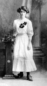 Surrey Hills Historical Society Collection
Photograph, Mabel Pye, daughter of William and Alice Pye of 12 Loch Street, Surrey Hills
Mabel Pye was a printmaker and painter. She was born in Box Hill in 1894, probably at the family’s Loch Street property. She was the daughter of Alice Eleanor Noar and her husband William Edward Pye, who married in 1893. William was known as Ted and is recorded in electoral rolls as a legal clerk and later as a public servant. Mabel had a sister Hazel who was also an artist, but less well known. 12 Loch Street, Surrey Hills was known as ‘Mulberry Hill’ and the Pyes appear to be the first occupants – Alan Holt’s register of Surrey Hills properties has them there from c1900. The property was originally about an acre in size and was later divided into 4 house blocks. In 1923 they built a house for themselves on one of the blocks facing Benwerrin Street and called it ‘Tanglewood’. The Loch Street house abutted the Surrey Hills Reservoir and was diagonally linked to the land in Benwerrin Street. In 2019 both the houses still stand. The family were involved in amateur theatre and at times the studio doubled as a rehearsal space for the Benwerrin Players, a group which operated through the late 1920s and early 1930s being comprised of friends and neighbours from Benwerrin Street and Windsor Crescent. Some of their performances were at the Surrey Hall in Union Road. Most of Mabel’s known work dates from the 1930s. She had studied under Bernard Hall at the National Gallery School. Mabel was a member of both the Victorian Artists Society from 1918-1941 and also the Melbourne Society of Women Painters and Sculptors from 1920-1950. Her work is represented in the Australian National Collection and in state galleries. The NGV has one of her works, the Gallery of NSW has 9 works, a large body of works and personal material is held by the Ian Potter Collection and there is one piece in the City of Whitehorse Collection. This ink sketch of the White Horse Hotel is signed MP and dated 1933, the year the building was demolished. A black and white studio photograph of a young lady standing beside a pedestal and wearing a light coloured dress with 3/4 length sleeves, dark stockings and lace up shoes. A corsage of dark flowers adorns the bodice. loch street, surrey hills, artists, whitehorse hotel, box hill, miss mabel pye, city of whitehorse collection, william edward pye, miss alice elanor noar, mrs alice eleanor pye, frank stamford -
Surrey Hills Historical Society Collection
Folder of information, Libby Cavenagh's 1990 building census of Wandsworth Road, Surrey Hills, 1990
Libby Cavenagh was Secretary of the Surrey Hills Historical Society. She completed this study as part of a Diploma of Local History she was undertaking at the University of New England. At the time she lived in Wandsworth Road.This is a unique analysis of the housing stock of a complete street at one point in time. Many of the houses have been altered since the study was completed and quite a number have been demolished.Blue folder of A4 size. This contains an analysis of each house in Wandsworth Road in 1990 with details regarding building style, approximate age, materials used, fence design, presence or absence of a garage or carport and some comment on the garden elements. For most entries there is a coloured photo taken from the street. For some there are photocopies of real estate advertisements. There are a number of appendices including s a map of the breakdown of styles and materials; date of construction and other information from the Camberwell Building registers 1890-1934; entries re owners from Sands & McDougall directories, 1897-1937; map from Land Titles Office showing sub-division information; land auction advertisements; information re W J Vine; list of builders; references.wandsworth road, libby cavenagh -
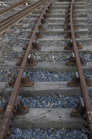 Puffing Billy Railway
Double Headed Rail, circa 1872 - 1883
Double Headed Rail from Ravenswood Station Siding which was dismantled circa 1987 the two rails were stored for a time at Maldon before being donated to Puffing Billy Museum Bearing makers marks of Wilson & Cammell - Dronfield- Steel works Wilson & Cammell made Steel rails at their Dronfield Steel Works, in Dronfield, North East Derbyshire, England from 1872 - 1883 Double-headed rail In late 1830s Britain, railway lines had a vast range of different patterns. One of the earliest lines to use double-headed rail was the London and Birmingham Railway, which had offered a prize for the best design. This rail was supported by chairs and the head and foot of the rail had the same profile. The supposed advantage was that, when the head became worn, the rail could be turned over and re-used. In practice, this form of recycling was not very successful as the chair caused dents in the lower surface, and double-headed rail evolved into bullhead rail in which the head was more substantial than the foot. Info from Wikipedia - Rail Profile https://en.wikipedia.org/wiki/Rail_profile The first records of double headed rail being used In Victoria by Victorian Railways was in 1859, the rails, chairs, oak and trenails were imported from UK. After the 1870’s the Victorian Railways went over to using flat bottom rails, but they still needed replacement double headed rail for lines already laid and this continued up to at least 1883 Wilson & Cammell - Dronfield- Steel works Wilson & Cammell made Steel rails at their Dronfield Steel Works, in Dronfield England from 1872 - 1883 Mount Alexander & Murray River Railway The Melbourne, Mount Alexander & Murray River Railway Company received parliamentary assent in February 1853 to build Victoria's first inland railway from Melbourne to Williamstown, and Melbourne to Bendigo and Echuca. Construction commenced in January 1854 with work on a pier at Williamstown but lack of funds slowed progress, eventually prompting the company to sell out to the government. The 100-mile (162 km) section to Bendigo opened in October 1862. Its cost of £35,000 per mile made it the most expensive railway ever built in Australia. In 1864, the line was extended to Echuca, tapping into the booming Murray-Darling paddlesteamer trade. info from Museums Victoria - Victorian Railways https://museumsvictoria.com.au/railways/theme.aspx?lvl=3&IRN=450&gall=456 1863 Ravenswood Station open on the 1st Feb 1863 Victorian Railways - purchased and imported the Rail and Chairs from Raleigh, Dalgleish, White and Co. London Importation of railway plant : abstract of a return to an order of the Legislative Assembly dated 27th June 1860 for - Copies of the advertisements calling for tenders, the names of the tenderers and the accounts and correspondence with Mr Brunel relating thereto GP V 1859/60 no. C 15 http://www.parliament.vic.gov.au/papers/govpub/VPARL1859-60NoC15.pdf Report from the Select Committee upon the Importation of Railway Plant : together with proceedings of the Committee, minutes of evidence and appendix GP V 1859/60 no. D 38 (2.9 MB) http://www.parliament.vic.gov.au/papers/govpub/VPARL1859-60NoD38.pdf Ravenswood Siding When the Victorian Railways were established in 1856 they adopted one of the popular British permanent way standards - heavy 80lb (36.3kg) double-headed rail held up right in cast iron chairs attached to transverse timber sleepers by wooden pegs called trenails. The Ravenswood Railway siding was constructed in 1862 with 12 feet wrought iron double-head rail held in cast iron chairs with Ransom and May patent compressed keys. Trenails held the chairs to the sleepers and the joints were secured in joint chairs. Joints were subsequently joined using fish plates. It formed part of the Melbourne to Echuca rail line, initially known as the Melbourne, Mt Alexander and Murray River Railway. George Christian Derbyshire, the first Engineer-in-Chair of the Victorian Railways was responsible for the design and construction of the works. No new lines were built in Victoria using double-headed rail after 1870. The siding was disconnected from the main line in 1988. The Ravenswood Railway Siding demonstrates the original 1856 philosophy of the Victorian Railways to adopt British permanent way technology. The siding demonstrates significant aspects in the development of permanent way technology in England and Victoria over the period from the 1830's to the 1880's. The chairs in the Ravenswood siding are physical evidence of early railway technology rendered obsolete 120 years ago, namely joint chairs at rail joints and trenails to secure the chairs to the sleepers. The double-headed rail demonstrates an important stage in the evolution of British rail technology in the 1830s. The old fish plates, square headed bolts and square nuts demonstrate the success of fishing the rail joins. The Ravenswood siding demonstrates the earliest form of rail joint technology developed in England, and existing in Australia, the joint chair. In part of the siding the sequence of joint and intermediate chairs is consistent with the 1856 specifications, that sequence is rare with the joints secured in joint chairs. The survival of chairs in this sequence is rare and almost certainly demonstrates that they remained in continuous use at the same location from 1862 to 1988. This remnant of the Ravenswood siding has survived 126 years. The siding has proved to be the most significant of extant remnant double-headed sidings in Victoria, containing a rare combination of early permanent way technologies. Construction dates 1862, Info from Ravenswood Railway Siding Victorian Heritage Database Report http://vhd.heritagecouncil.vic.gov.au/places/4693/download-report The remaining section of this siding is significant at the State and National levels in that it demonstrates the use of chaired rail by the Victorian Railways Department for the Trunk Lines and, more particularly, the following stages in the evolution of this long obsolete method of permanent way construction: a) The use of joint chairs and intermediate chairs at regular intervals inferring that the original wrought iron rail lengths were 12 feet, as is known through documentary sources to have been the case. The survival of chairs in this sequence is unique and almost certainly demonstrates that they have remained in continuous use at the same location and in the same sequence from 1862 to 1988 . b) The use of joint chairs and intermediate chairs designed for use with trenails. c) The use of later intermediate chairs designed for use with steel pins and the use of fished joints with steel double head chaired rail, representing a second method of constructing the permanent way using chaired rail technology. info from Ravenswood Siding - Melbourne/Echuca Railway Line - Victorian Heritage Database Report http://vhd.heritagecouncil.vic.gov.au/places/70103/download-report Addition to Citation for Melbourne to EchucaRailway Line 1/10/1990 Double Head Rail The surviving lengths of double head rail with chairs on this railway compare with one surviving similar remnant on the Geelong to Ballarat railway and are representative of permanent way construction techniques applied exclusively to the two trunk railways of the 1860's. In this respect they are rare survivors and may be unique at the national level and of technical importance at the international level to the extent that they enhance contemporary understanding of early railway building technology. Surviving lengths of chaired double head rail survive at Kyneton, Ravenswood and Bendigo on this railway and include a number of different types of cast iron intermediate and joint chairs with hardwood keys and metal pins. The Ravenswood siding is of special significance for the diversity of chair types and for the sequence of chairs recalling rail lengths known to be associated with construction of the line in 1862. Construction of the Railway Tenders closed on 24 March 1858 with no less than 133 tenders being received. A contract was let to Cornish and Bruce for £3,356,937 to commence work on 1 June 1858 and complete the line by 31 July 1861. Cornish and Bruce made quick early progress with the Melbourne to Sunbury section being officially opened on 13 January 1859. The line was officially opened to Bendigo (Sandhurst) on 20 October 1862 by the Governor of Victoria, Sir Henry Barkly. A great banquet was held for 800 guests and this was followed by a grand ball. The extension of the line to Echuca was a relatively simple matter as that part of the line was across plain country without any significant engineering challenges. Tenders were called for the work in 1863 and the work was completed in 1864 by contractors Collier and Barry Apart from the line contractors, other firms directly involved were J Shire law and Co (sleepers), R Fulton, Langlands Brothers and Co, William Crossley (water supply), B Moreland, Langlands Brothers and Co (platelayers lorries), E Chambers (iron pins, traversers), Miller and McQuinstan (luggage vans and steam engines) and various contractors for building works. Info from Engineers Australia Engineering Heritage Victoria Nomination for Recognition under the Engineering Heritage Australia Heritage Recognition Program for the Goldfields Railways - Melbourne , Bendigo & Echuca Railway Page 25 - .2.9.2 Statement from National Trust of Australia (Victoria) Listing number B5323 for Mt Alexander/Murray Valley Rail Line: Page 69 - Theme 3 https://www.engineersaustralia.org.au/portal/system/files/engineering-heritage-australia/nomination-title/Melbourne_%20Bendigo_Echuca%20Railway%20Nomination.pdf The Melbourne, Mount Alexander and Murray River Railway Company was a railway company in Victoria, Australia. It was established on 8 February 1853 to build a railway from Melbourne to Echuca on the Victorian-NSW border and a branch railway to Williamstown. The company struggled to make any progress and on 23 May 1856, the colonial Government took over the Company and it became part of the newly established Department of Railways, part of the Board of Land and Works. The Department of Railways became Victorian Railways in 1859. Construction of the Bendigo line commenced in 1858, but this private consortium also met with financial difficulties when it was unable to raise sufficient funds, and was bought out by the Victorian colonial government. The design work was then taken over by Captain Andrew Clarke, R. E., Surveyor-General of Victoria, with bridge designs completed by Bryson and O'Hara The contract for the first stage of the line from Footscray to Sandhurst (now Bendigo), was let to Cornish and Bruce for £3,356,937.2s.2d ($6.714 million) with work commencing on 1 June 1858. Completion of the permanent way was to be by 31 July 1861 https://en.wikipedia.org/wiki/Melbourne,_Mount_Alexander_and_Murray_River_Railway_Company Victorian Railways - purchased and imported the Rail and Chairs from Raleigh, Dalgleish, White and Co. London Importation of railway plant : abstract of a return to an order of the Legislative Assembly dated 27th June 1860 for - Copies of the advertisements calling for tenders, the names of the tenderers and the accounts and correspondence with Mr Brunel relating thereto GP V 1859/60 no. C 15 http://www.parliament.vic.gov.au/papers/govpub/VPARL1859-60NoC15.pdf Report from the Select Committee upon the Importation of Railway Plant : together with proceedings of the Committee, minutes of evidence and appendix GP V 1859/60 no. D 38 (2.9 MB) http://www.parliament.vic.gov.au/papers/govpub/VPARL1859-60NoD38.pdf Victorian Railways : report of the Board of Land and Works November 1862 GP V 1862/63 no. 21 (2.8 MB) https://www.parliament.vic.gov.au/papers/govpub/VPARL1862-63No21.pdfHistoric - Victorian Railways - Double Headed rail Ravenswood Railway Station and Siding Victorian Heritage Database Reports Victorian Heritage Register VHR H1100 Victorian Heritage Register VHR H1786 National Trust VHR H1100 Mount Alexander and Murray River Rail way Line National Trust2 rail lengths of Double Headed Rail made of Iron makers marks : Wilson & Cammell - Dronfield - Steel and 20 joint chairs with metal rail pins Makers mark Wilson & Cammell - Dronfield - Steel (possible date 187? very hard to read ) puffing billy, double headed rail, wilson & cammell - dronfield - steel works, ravenswood station siding, melbourne to echuca rail line, initially known as the melbourne, mt alexander and murray river railway. -
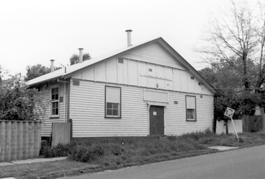
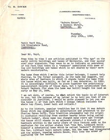 Robin Boyd Foundation
Letter, G. R. Locke, G R Locke to Robin Boyd, 15.07.1952
The letter writer G. R. Locke has read Robin Boyd's newspaper articles on early public buildings and homes. This letter tells Boyd about the historic home "Auburn House", 4 Goodall St Hawthorn, established for Robert Hepburn with land purchased in 1856. It also tells of the confusion with neighbouring house "Auburn Lodge". Since Boyd writes on early Melbourne public buildings and homes, the writer is inviting Boyd to view the house. It is not known whether Robin Boyd took up the invitation. In 1960 it was included in the National Trust Register. -
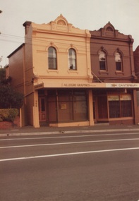 Surrey Hills Historical Society Collection
Photograph, 386-384 Canterbury Road Surrey Hills
The donor, Bob Lennox believed that these were the work of his great-grandfather William Lennox and his builders. William and his son were plasterers and often used the shell motif which is seen on the pediment of the buildings. These two terraces were part of the retail development of five terraces along Canterbury Road which were constructed on land subdivided from the parcel of land originally owned by John Woodhead. The Alan Holt register of properties in 3127 gives a list of proprietors / residents at the beginning of each decade from 1890-1980. There are also earlier photos depicting these buildings in the collection. These buildings have been included in the City of Boroondara Heritage Overlay Union Road Commercial Precinct 2011, Surrey Hills.These buildings were amongst the first commercial buildings serving the area of Surrey Hills and followed the extension of the railway from Camberwell in 1883.A colour photo with rounded corners taken from slightly diagonally across Canterbury Road from 2 double-storey Victorian style buildings. Both have the decorative shell motif in the pediment.Back of photo in green pencil "CANTERBURY RD SURREY HILLS / EAST OF UNION RD"victorian style, allegro graphics, william lennox, 386-384 canterbury road, shops, victorian terraces, canterbury road, surrey hills, john woodhead, heritage overlay union road commercial precinct 2011, heritage overlays -
 Surrey Hills Historical Society Collection
Photograph - Mrs Long's house, Delta Street area, Surrey Hills
The property is in the area that later became Delta Street, on the north side of Back Creek. Once roads were made and streets numbered, this became 1 Delta Road, Surrey Hills. Part of the undeveloped land would become part of South Surrey Park. According to Alan Holt's property register the house was built in c1920 and was demolished after having been neglected in 1991. He records it having had various names: 'Westward Ho', 'Pembroke' and 'The Oaks'. The first owner from 1920 was Eric Rowland Handyside Long who married Agnes May Hay Murray in March 1920. They had one son James Murray Long, born in September 1921. They divorced in 1937 and thereafter the property is listed in the name of Mrs Mary Hay Long, James M Long or Miss Mary Hay Long. According to Alan Holt, the house featured in the television series 'Carson's Law' in c1984.This is one of relatively few photos which record the transformation of rural land into the suburb that became Surrey Hills.A simple dark-stained timber house with a veranda and tiled roof. It is simply fenced with posts and wire mess. There are other houses in the background but part of the area remains as open space.delta road, back creek, south surrey park, wetward ho, pembroke, the oaks, hose names, miss agnes may hay murray, mrs agnes may hay long, mrs mary hay long, miss mary hay long, james murray long, carson's law -
 Surrey Hills Historical Society Collection
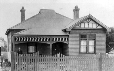
Photograph, 44 Guildford Road Surrey Hills, 1940
This was the home of the Offszanka family from 1913; they came to Surrey Hills from Richmond. Carl Theodore Offszanka (1874-1944) was a furrier. Both he and his wife Ida, nee Schade, (1882-1963) were born in Germany. They married in Victoria in 1908. Their home was called 'Westfalia' (ref: 1919 electoral roll), presumably after the region in NW Germany. They had at least 4 children: Carl Bernard - b 1909 Marie Eliese - b 1910 Erna Helena - b 1913; d 1996 - listed at Guildford Road in electoral rolls. Bernard George - b 1914; d 1987 (Surrey Hills) - listed at Guildford Road in electoral rolls. The family were associated with Our Holy Redeemer and also donated class photos of the school to the collection. Carl and Ida are buried in Box Hill Cemetery (RC 032-0034). The semi-circular bay window is not original to the house. This home has had a 2nd storey added to it in late 1990s. According to a family descendant (REF: Email 1/8/20 from grandson) Carl Theodor Offszanka purchased the home in 1913 for £616. He also purchased the adjoining vacant block of land at 42 Guildford Road and ran a large orchard on it before later selling it. This appears to have been between 1920-1930. The family continued to occupy the house until after 1980 when Erna Helena and Bernard George are listed in the electoral rolls. Our property register lists Erna Helena Offszanka as the last member there. She died on 5 May 1996. Members of the Offszanka family lived in this property from its beginnings for more than 70 years. Such longstanding tenancy is unusual.Black and white photo of a timber Edwardian home at 44 Guildford Road Surrey Hills. The home has 2 bricks chimneys, a corrugated iron roof, timber fretwork to the verandah and a semi-circular bay window. The facade of the house is partially obscured by mature garden, possibly including large camellias, with rock-edged garden beds and a central path. The front fence is not visible.edwardian style, guildford road, offszanka family, carl theodor offszanka, ida schade (miss), carl bernard offszanka, bernard george offszanka, westfalia, ida offszanka (mrs), erna helena offszanka (miss), marie eliese offszanka (miss) -
 Surrey Hills Historical Society Collection
Photograph, 44 Guildford Road, Surrey Hills, c1915, 1913-1915
The gentleman in the photo is an estate agent. According to a grandson (REF: Email 1/8/2020) the original photos is thought to have been a publicity photo for the real estate agency. Carl Theodore Offszanka (1874-1944) was born in Germany. He is listed in electoral rolls at 44 Guildford Road from 1915, occupation furrier, with his wife Ida (nee Schade, 1882-1963), also born in Germany. They were married in Victoria in 1908. In later electoral rolls at the same address are Erna Helena (b 1913; d 1996) and Maria Eliese (b 1910; m Benedict Francis Rieusset in 1936). Both daughters are listed as typists. Also listed is Bernard George (b 1914; d 1987) who in later electoral rolls is described as a process worker. He served in the AIF in the Second World War. Not listed is Carl Bernard b 1909. The Offszanka family lived at 44 Guildford Road from 1913 until post-1980; they came to Surrey Hills from Richmond. Their home was called 'Westfalia' (ref: 1919 electoral roll), presumably after the region in NW Germany. It is not known when Carl and Ida migrated from Germany. This home has had a 2nd storey added to it in late 1990s. According to a family descendant (REF: Email 1/8/20 from grandson) Carl Theodor Offszanka purchased the home in 1913 for £616. He also purchased the adjoining vacant block of land at 42 Guildford Road and ran a large orchard on it before later selling it. This appears to have been between 1920-1930. The family continued to occupy the house until after 1980 when Erna Helena and Bernard George are listed in the electoral rolls. Our property register lists Erna Helena Offszanka as the last member there. She died on 5 May 1996. Black and white photo of a ? dark-stained timber Edwardian home at 44 Guildford Road, Surrey Hills. It has 2 brick chimneys, a corrugated iron roof and timber fretwork to the veranda. There is a single window to the veranda, 2 single windows down the LHS (facing) side of the house and a double window to the RHS (facing) side of the house. This appears to have coloured glass to the top section. The gable is decorated with timber and stucco and has a simple finial. The house has a simple timber picket fence and a driveway down the LHS (facing), in which a carriage is located. A gentleman in a hat stands on the veranda. A tall Victorian building can be seen in the far distance, on Canterbury Road.edwardian architecture, houses, guildford road, mr bernard george offszanka, mrs ida offszanka, miss ida schade, miss erna helena offszanka, miss marie eliese offszanker, furriers, mr carl theodor offszanka, westfalia, mr carl bernard offszanka -
 Surrey Hills Historical Society Collection
Photograph, Horse and buggy at 44 Guildford Road Surrey Hills, 1913
Jocelyn Hall indicated in notes that the gentleman could possibly be an estate agent. This was confirmed by a grandson of the original owners. (REF: Email 1/8/2020) The original photos is thought to have been a publicity photo for the real estate agency. Carl Theodore Offszanka (1874-1944) was born in Germany. He is listed in electoral rolls at 44 Guildford Road from 1915, occupation furrier, with his wife Ida (nee Schade, 1882-1963), also born in Germany. They were married in Victoria in 1908. In later electoral rolls at the same address are Erna Helena (b 1913; d 1996) and Maria Eliese (b 1910; m Benedict Francis Rieusset in 1936). Both daughters are listed as typists. Also listed is Bernard George (b 1914; d 1987) who in later electoral rolls is described as a process worker. He served in the AIF in the Second World War. Not listed is Carl Bernard b 1909. The Offszanka family lived at 44 Guildford Road from 1913 until post-1980; they came to Surrey Hills from Richmond. Their home was called 'Westfalia' (ref: 1919 electoral roll), presumably after the region in NW Germany. It is not known when Carl and Ida migrated from Germany. This home has had a 2nd storey added to it in late 1990s. According to a family descendant (REF: Email 1/8/20 from grandson) Carl Theodor Offszanka purchased the home in 1913 for £616. He also purchased the adjoining vacant block of land at 42 Guildford Road and ran a large orchard on it before later selling it. This appears to have been between 1920-1930. The family continued to occupy the house until after 1980 when Erna Helena and Bernard George are listed in the electoral rolls. Our property register lists Erna Helena Offszanka as the last member there. She died on 5 May 1996. The Offszanka family occupied this home from its beginning for over 70 years. Such long-term occupancy by one family is unusual.Black and white photo of a ? dark-stained timber Edwardian home at 44 Guildford Road, Surrey Hills. A hooded buggy is located in the rough driveway at the side of the house. A gentleman in a hat and with a moustache is seated in the buggy. A tall building can be seen in the far distance and a street leading up the hill from Canterbury Road.edwardian style, houses, guildford road, horse drawn vehicle, carl theordore offszanka, miss ida schade, mrs ida offszanka, miss edna helena offszanka, miss marie elsie offszanka, mr bernard george offszanka, estate agent, mr carl bernard offszanka, westfalia -
![View of the Township of Fernshawe / [by] Nicholas Caire, circa 1876](/media/collectors/550653872162f11fb04854aa/items/57775425d0cdd10a5c17a3fd/item-media/57775483d0cdd10a5c17c7c0/item-fit-380x285.jpg) Kew Historical Society Inc
Kew Historical Society IncPhotograph, Anglo-Australasian Photographic Company, View of the Township of Fernshawe, c. 1876
Nicholas Caire was born on Guernsey in the Channel Islands in 1837. He arrived in Adelaide with his parents in about 1860. In 1867, following photographic journeys in Gippsland, he opened a studio in Adelaide. From 1870 to 1876 he lived and worked in Talbot in Central Victoria. In 1876 he purchased T. F. Chuck's studios in the Royal Arcade Melbourne. In 1885, following the introduction of dry plate photography, he began a series of landscape series, which were commercially successful. As a photographer, he travelled extensively through Victoria, photographing places few of his contemporaries had previously seen. He died in 1918. Reference: Jack Cato, 'Caire, Nicholas John (1837–1918)', Australian Dictionary of Biography, National Centre of Biography, Australian National UniversityAn original, rare photograph from the series 'Views of Victoria: General Series' by the photographer, Nicholas Caire (1837-1918). The series of 60 photographs that comprise the series was issued c. 1876 and reinforced a neo-Romantic view of the Australian landscape to which a growing nationalist movement would respond. Nicholas Caire was active as a photographer in Australia from 1858 until his death in 1918. His vision of the Australian bush and pioneer life had a counterpart in the works of Henry Lawson and other nationalist poets, authors and painters.Albumen silver photograph mounted on board. [Note: This is the first of two copies of this photograph in the collection]printed in ink on support l.c.: VIEW OF THE TOWNSHIP OF FERNSHAWE. / COPYRIGHT REGISTERED. printed in ink on support reverse c.: VIEWS OF VICTORIA. / (GENERAL SERIES.) / No. 14. / VIEW OF THE TOWNSHIP OF FERNSHAWE. / Fernshawe may be considered the most romantic town in the Colony of Victoria. It is situated at the foot of / the Black Spur, and is surrounded by a great many high hills, such as Mounts Riddell, Juliet, Munday, and others, / which form the crossing range into Gipps Land. It has, no doubt, derived its name from the fact that it is the / greatest Fern-growing district in the Colony. printed in ink on support reverse l.c.l.: J.W. FORBES, Agent, printed in ink on support reverse l.c.: ANGLO-AUSTRALASIAN PHOTOGRAPHIC COMPANY, MELBOURNE. printed in ink on support reverse l.c.r.: 10 Temple Court, Collins Street West.nicholas caire (1837-1918), landscape photography, fernshawe -
![View of the Township of Fernshawe / [by] Nicholas Caire, circa 1876](/media/collectors/550653872162f11fb04854aa/items/57775578d0cdd10a5c183f96/item-media/577755dfd0cdd10a5c18731c/item-fit-380x285.jpg) Kew Historical Society Inc
Kew Historical Society IncPhotograph, Anglo-Australasian Photographic Company, View of the Township of Fernshawe, c. 1876
Nicholas Caire was born on Guernsey in the Channel Islands in 1837. He arrived in Adelaide with his parents in about 1860. In 1867, following photographic journeys in Gippsland, he opened a studio in Adelaide. From 1870 to 1876 he lived and worked in Talbot in Central Victoria. In 1876 he purchased T. F. Chuck's studios in the Royal Arcade Melbourne. In 1885, following the introduction of dry plate photography, he began a series of landscape series, which were commercially successful. As a photographer, he travelled extensively through Victoria, photographing places few of his contemporaries had previously seen. He died in 1918. Reference: Jack Cato, 'Caire, Nicholas John (1837–1918)', Australian Dictionary of Biography,An original, rare photograph from the series 'Views of Victoria: General Series' by the photographer, Nicholas Caire (1837-1918). The series of 60 photographs that comprise the series was issued c. 1876 and reinforced a neo-Romantic view of the Australian landscape to which a growing nationalist movement would respond. Nicholas Caire was active as a photographer in Australia from 1858 until his death in 1918. His vision of the Australian bush and pioneer life had a counterpart in the works of Henry Lawson and other nationalist poets, authors and painters.Albumen silver photograph mounted on board. [Note: This is the second of two copies of this photograph in the collection]printed in ink on support l.c.: VIEW OF THE TOWNSHIP OF FERNSHAWE. / COPYRIGHT REGISTERED. printed in ink on support reverse c.: VIEWS OF VICTORIA. / (GENERAL SERIES.) / No. 14. / VIEW OF THE TOWNSHIP OF FERNSHAWE. / Fernshawe may be considered the most romantic town in the Colony of Victoria. It is situated at the foot of / the Black Spur, and is surrounded by a great many high hills, such as Mounts Riddell, Juliet, Munday, and others, / which form the crossing range into Gipps Land. It has, no doubt, derived its name from the fact that it is the / greatest Fern-growing district in the Colony. printed in ink on support reverse l.c.l.: J.W. FORBES, Agent, printed in ink on support reverse l.c.: ANGLO-AUSTRALASIAN PHOTOGRAPHIC COMPANY, MELBOURNE. printed in ink on support reverse l.c.r.: 10 Temple Court, Collins Street West.nicholas caire (1837-1918), landscape photography, fernshawe -
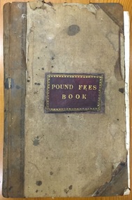 Kew Historical Society Inc
Administrative record (item), Borough of Kew, Pound Fees Book, 1874-1896
While the first successful land sales in Boroondara occurred in Hawthorn in 1843, and Kew in 1845, these areas were to be without local pounds until April 1858, when the Governor of Victoria, in accordance with Act 18 Victoria No 30, was pleased to direct the establishment of a Pound at Glass’s Creek on that part of land bounded by the Kilby Road, Burke Road and High Street. While the Governor was required to proclaim the establishment of a pound, the appointment of a poundkeeper was the responsibility of the Justices of the Peace in the local Court of Petty Sessions. The Pound took its name from the most distinctive natural feature of the area, Glass’s Creek, named after the early pastoralist Thomas Glass.The register is of historic significance as an indicator of suburban life in the second half of the 19th Century. It shows how farming and city life on the urban fringe were intimately connected. It is also significant to the early history of Hawthorn and Kew, who both claimed the Pound following their separation from the Boroondara Roads Board in 1861."Kew Pound Book"glass creek pound (kew), animal pound, dog pound, kew pound, j. smith, john oakes, samuel b. cash, edward s. delaney, emma oswin, samuel cash -
Whitehorse Historical Society Inc.
Document, Biography of Dr Francis John Drake, 1/11/1983 12:00:00 AM
A brief biography of Doctor Francis John Drake - medical practitioner and early land owner in the Mitcham area.A brief biography of Doctor Francis John Drake - medical practitioner and early land owner in the Mitcham area. Compiled by Andrew Hillier. Includes copies of Dr Drake's Marriage Certificate, entry in Register of Deaths and a portrait.A brief biography of Doctor Francis John Drake - medical practitioner and early land owner in the Mitcham area. drake, francis john, dr, park road, mitcham, heads road, donvale, mitcham north, whitehorse road, mitcham, elizabeth street, mitcham, station street, mitcham, colombo street, . mitcham, mitcham road, mitcham, doncaster east road, mitcham, mcdowall street, mitcham -
Whitehorse Historical Society Inc.
Document, Crown Grant Register, 10/05/1999
Crown Grant Register - General Law - Parish of Nunawading, 1854 - 1858. Lands Department plan of Parish, 1864.land settlement, victoria. lands department, blood, robert, blood, thomas, burrell, charles, clisby, william, cook, charles, cousens, james, dickensen, william, harding, william, hedding, william, holland, john, jones, william, kefford, richard, lobb, john, morgan, robert rowland, morton, william, o'conner, patrick, orr, joseph, polak, nelson, riley, patrick, smith, l l dr, tranter, william, whitman, francis, williams, william, wilks, joseph, wilson, william, wilton, edward -
Whitehorse Historical Society Inc.
Legal record - Land Title, Blackburn roads, 1890-1854
Certificate of Title Vol.2301 Fol.172 to Freehold Investment and Banking Company of Australia Limited dated 19 September 1890, for pieces of land with frontages on Blackburn Road, Canterbury Road, Lake Road and Central Road Blackburn.Certificate of Title Vol.2301 Fol.172 to Freehold Investment and Banking Company of Australia Limited dated 19 September 1890, for pieces of land with frontages on Blackburn Road, Canterbury Road, Lake Road and Central Road Blackburn. With transfers registered 1909-1954Certificate of Title Vol.2301 Fol.172 to Freehold Investment and Banking Company of Australia Limited dated 19 September 1890, for pieces of land with frontages on Blackburn Road, Canterbury Road, Lake Road and Central Road Blackburn. blackburn road, blackburn, central road, blackburn, canterbury road blackburn, lake road, blackburn, freehold investment and banking company of australia ltd, jeffery, mary ann, jeffery, cyril edgar, morton, louisa mary esther, halley, ethel may -
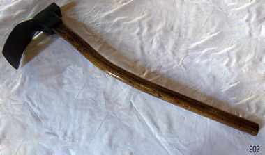 Flagstaff Hill Maritime Museum and Village
Tool - Adze, Ward & Payne Ltd, Between 1843 to Mid 20th Century
An adze is an ancient and versatile cutting tool and has been in use for thousands of years. Adze are similar to an axe but with the cutting edge perpendicular to the handle rather than parallel. They have been used since the Stone Age. Adzes are hand tools used for smoothing or carving wood. The subject item was made by Ward & Payne of the Limbrick Works at Hillsborough, Sheffield England manufacturers of hand-forged tools. Their trademark registered in 1850 was a Letter "W" & "P" stamped into the steel. The firm was established by David Ward (1767-1822) in 1803 the company became David Ward & Sons, in 1837 after Ward's son Edward joined the firm. In 1845 Henry Payne the founder's son-in-law became a partner but died in 1850 after which the company reverted to the Ward family. The business then concentrated on making carving tools, chisels and gouges. In 1882 David Ward's grandson David Ward Jr. (1835-1889) purchased land and built a factory at Sheffield North known as the "Limerick Wheel". For a time Wards operated from both 106-114 West Street Sheffield and at Limbrick Road, Hillsborough on the river Loxley. By 1911 they had expanded into making spades, forks, sheep shears and many other types of edged tools including drills and wood planes. In 1967 Wilkinson Sword purchased all the company's share capital and continued to sell Ward & Payne tools until 1970 when a fire burned the factory down and housing development was built on the site.The subject item is significant as it gives a snapshot of the technological development of sailing ships and their operation before steam-powered vessels took over around the world. Tools such as the subject item demonstrate the traditional craftsmanship and skill of the shipwright and the aesthetic quality of the timber ships designs of the time. Adze with wooden handle curved painted green with patent number and maker's name inscribed on inside curve of blade. Inscribed "Patd 561 Ward" "2w". flagstaff hill, warrnambool, flagstaff-hill, flagstaff-hill-maritime-museum, maritime-museum, shipwreck-coast, flagstaff-hill-maritime-village, smoothing tool, hand tool, carpenders tool, adze, coopers tool, woodworking tools -
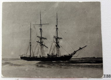 Flagstaff Hill Maritime Museum and Village
Photograph, circa 1888
This photograph was taken close to the time of the wreck of the "Edinburgh Castle". The “Edinburgh Castle”, three-masted iron barque, was built in Glasgow, Scotland, in 1863 by J.G. Lawrie. She was 53.7 meters long and weighed 627 tons. She was owned by shipping company T Skinner and Co and registered at Liverpool, England. She sailed from 1863 to 1885 along the trade route between Scotland, China, and Singapore. In 1887 the Master, Captain J.B. Darling, sailed the “Edinburgh Castle” for its new owners Gifford & Nicholson from London to Warrnambool. Her cargo was 4,900 casks of cement for the construction of the new Warrnambool Breakwater. Over the three month journey, the ship met with rough weather and even a hurricane. On January 15th 1888 the “Edinburgh Castle” approached Lady Bay where a welcoming crowd gathered. The Port’s relief Harbour Master, Pilot Carless took over to complete the docking. As he tried to guide her, the Lighthouse Keeper signalled that the ship was too close to shore. The pilot continued on his course, causing her to ‘miss stays’ (make an incorrect tack). The crew dropped anchors and tried to lighten the load by throwing some of the casks of cement overboard but this was to no avail, and she drifted sideways in calm waters, lodging in the sand. A distress signal was sent to the coastal steamer “Julia Percy”, which spent several hours trying to pull the stranded ship away, but it would not budge. Those involved hoped to re-float the ship but efforts to save the vessel were useless. The captain and some crew stayed on board. When the weather became rough the rocket crew brought its lifesaving gear to the shore, ready to launch a line to the ship. The three men on board sent those onshore a message in a bottle to assure the on-lookers that they were quite comfortable to stay aboard. After a night of bad weather, the crew were glad to accept the rocket crew’s help and were in turn safely hauled to shore in a breeches buoy. The ship broke up quickly. Very little of the cargo could be saved. A week later all that could be seen of her was the bow and some of the stern. The beach was littered with wreckage, including cement cask fragments, for weeks. Ironically, on the morning after the ship ran aground, the very same “Edinburgh Castle” was offered for sale at an auction in Melbourne, billed as “a sound ship with all the fittings and in the best order.” The sale was completed before they heard the news that the ship was totally wrecked! Over the decades the shifting sands concealed the wreck of “Edinburgh Castle”. However, in October 1985 two local divers, Peter Ronald and Colin Goodall discovered her near the Hopkins River mouth. Peter said in his book ‘Exploring Shipwrecks of Western Victoria’, “In the midst of this sand-cloud I could clearly see row after row of neatly stacked barrels”. He remarked, “I am privileged to have had at least a glimpse of one of Warrnambool's most significant wrecks.” Some 15 – 17 ships are believed to have sunk in Lady Bay, but only two have been discovered on the seafloor; the “Edinburgh Castle” and the “La Bella”. Both wrecks are popular diving sites and are preserved as significant historical marine and marine archaeological sites. The sailing ship “Edinburgh Castle” is of local and state and national significance. It is one of the only two shipwrecks discovered in Lady Bay, Warrnambool, out of the 15-17 shipwrecks in the bay. The “Edinburgh Castle” is significant for being one of the largest vessels lost in the bay. The significance of the wreck of the “Edinburgh Castle” was recognised by being listed on the Victorian Heritage Database VHR S209. She was declared an Historic Shipwreck on 17th January 1989 under the Commonwealth Historic Shipwrecks Act (1976). The “Edinburgh Castle” wreck is also significant for the connection of its cargo with the building of the Warrnambool Breakwater, also listed on the Victorian Heritage Database VHR H2024. The “Edinburgh Castle” is included as one of the shipwrecks in Heritage Victoria’s Historic Shipwreck Trail on Victoria’s West Coast. Black and white photograph of the iron barque 'Edinburgh Castle' on breaking waves, land in the background. The ship was stranded and wrecked in Lady Bay, Warrnambool, on January 15th 1888. Figures are standing on deck. The masts are free from sails.flagstaff hill, warrnambool, shipwrecked-coast, flagstaff-hill, flagstaff-hill-maritime-museum, maritime-museum, shipwreck-coast, flagstaff-hill-maritime-village, great ocean road, edinburgh castle barque 1863, edinburgh castle shipwreck 1888, shipwreck 15-05-1888, glasgow ship, jg lawrie, t skinner and co, liverpool ship register, captain j.b. darling, gifford & nicholson, cement casks, cement barrels, warrnambool breakwater construction, breaches buoy, rocket crew, rocket launcher, lifesaving equipment, warrnambool harbour, lady bay warrnambool, ship pilot carless, lady bay shipwreck, peter ronald, colin goodall, lady bay diving site, marine archaeology, victorian heritage register, vhr s209 -
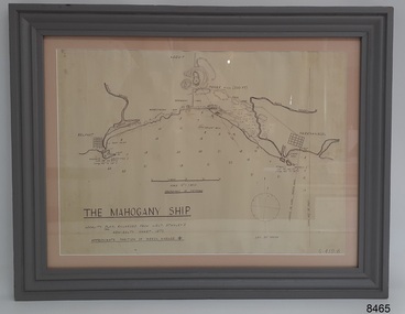 Flagstaff Hill Maritime Museum and Village
Document - Location Chart, The Mahogany Ship, 2007
This chart shows a possible site for the fabled wreck called the 'Mahogany Ship'. Flagstaff Hill’s collection includes other objects that some say could be relics from this Ancient Wreck, (also called the Gold Ship, or the Ancient Vessel). The chart shows the coordinates for the Summits of Griffith Island and of Middle Island. It also has the depths of the sea at various intervals and shows the shore and sand dunes, lighthouses and other reference points. The mystery of the Mahogany Ship began in 1836 when two shipwrecked sealers discovered the remains of an “ancient vessel” in the sand dunes about four miles west of Warrnambool. Since the last recorded sightings in the 1880’s the true origin of the Mahogany Ship has remained one of Australia’s most famous historical mysteries or fables. One of the more recent theories is that the vessel was one of the Portuguese ships exploring the Australian coast in 1522. For over one hundred years searchers have attempted to locate and identify the wreck. The search continues for the tangible evidence which will once and for all establish the Mahogany Ship’s place in Australia’s History.The chart represents the worldwide interest in locating the wreck of the Mahogany Ship. Locating the actual wreck or proving the existence of a Portuguese ship's wreck could change the history of the discovery of Australia. A Mahogany Ship committee was formed to gather and research information about the discovery of the wrecked ship. A large amount of money was offered as a prize for finding the wreck or parts of it. People have written books, painted images, made videos and told tales of the ship but it continues to remain a mystery or even a fable. The chart is significant for its possible link to one of Victoria’s and Australia’s maritime mysteries, the Mahogany Ship (also known as the Ancient Wreck). It is one of very few known relics that could give evidence of the existence and history of the vessel. It is listed on the Victorian Heritage Register S438 as it is one of Victoria’s oldest recorded shipwrecks. The identity of the vessel has the potential to change Australia’s history.A chart in a wooden frame, behind glass. The chart shows the approximate position of the mystery Ancient Wreck, later called the "Mahogany Ship". The chart is a copy and is based on the Admiralty Chart by Lieut. Stanley, dated 1872. Lower left: "THE MAHOGANY SHIP" "LOCALITY PLAN, ENLARGED FROM LIEUT. STANLEY'S ADMIRALTY CHART 1872" "APPROXIMATE POSITION OF WRECK MARKED [symbol of a Portuguese cross]" Other labels on chart: "BELFAST" "PORT FIARY" "GRIFFITHS I" "RIVER MOYNE" "RIVER MERRI" "ARMSTRONG BAY" " GORMANS LANE" "TOWER HILL" "KOROIT" "HELEN ROCK" "WARRNAMBOOL" "LADY BAY" "MIDDLE I" "LIGHT HO." Lower right: "G 410 B" Label on the back; "This chart presented to the Mahogany Ship Committee and Flagstaff Hill by Avis Quarrell, April 2007"warrnambool, shipwrecked coast, flagstaff hill maritime museum, shipwreck coast, mahogany ship, ancient vessel, ancient wreck, portuguese ship, coastal reserve, fabled wreck, gold ship, griffiths island, belfast (now port fairy), koroit, location plan, leuit. stanley, admiralty chart 1872, tower hill, merri river, moyne river, middle island, helen rock, armstrong bay, griffiths land