Showing 2270 items
matching parish.
-
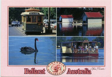 Ballarat Tramway Museum
Postcard, Steve Parish Publishing Pty Ltd, "Ballarat Australia" and "Victoria Collection", 2003
Printed full colour postcard titled "Ballarat Australia" and "Victoria Collection". Features photos of BTM No. 27, Lake Wendouree, black swan and paddle board. On rear is places for correspondence, stamp, barcode, address and publisher logo. Has the name of the publisher "Steve Parish" Steve Parish No. PC3036 and address details. trams, tramways, btm, wendouree parade, gardens, lake wendouree, swans -
 Kew Historical Society Inc
Plan - Subdivision Plan, J Hurrey, Section 115 in the Parish of Boroondara Near Richmond Bridge, 1853
Despite the plans claims that it is a subdivision near the Richmond Bridge, Section 115 was located at what is now Camberwell Junction. While the plan only lists government roads rather than named streets, the section was located on the east side of Burke Road, stretching up the hill from the current Junction. Research on Trove, conducted by Kerry Fairbank, discovered an advertisement for unsold lots in Section 115 which clarifies the extent and location of subsequent land sales in the original section. The original article can be viewed through the link in the catalogue record. The interesting link to Kew is the reference to James Beavan as the purchaser of lots 14 and 15. The historian Gwen McWilliam has notes that a Mr Beavan changed his name from Bevan. The Bevans were descendants of the Derricks family of Kew. This subdivision plan is the earliest original map or plan in the collection which shows parts of what is now the City of Boroondara, dating from circa 1853. It provides important information for researchers on subsequent subdivisions following the original land sales in [Camberwell] Boroondara. The site, on the east side of Burke Road is a highly-significant and historic site. This is believed to be the only extant copy of the subdivision in public collections.A small plan on parchment listing 28 lots, between one and two acres each, for sale in Section 115 in the Parish of Boroondara, dating from 1853 when the portion was subdivided.Obverse: Lot 16 "Joseph Duval", Lots 14 & 15 "James Beavan". Other annotations (measurements) are unreadable. Reverse: "KH-981 / Section 115 in the Parish of Boroondara / Near Richmond Bridge / 1640T. / J Duval / 14-15 J. Beavanparish of boroondara, subdivision plans - camberwell, section 115 - boroondara, subdivision plans -- camberwell (vic), riverscape road, burke road, camberwell junction -
 Federation University Historical Collection
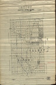
Plan - map, Ascot: Counties of Ripon and Talbot, 18/12/1920
Cadastral map showing parish boundaries and land ownership. "L5270"Maps parishes located in Ascot area. Photo-Lithographed at the Dept. of Lands and Survey.Highlighted parish labelled, Mrs E.C.Sutherland.parish, map, ascot, counties, e. c. sutherland, a. cameron, sweeney, w. j. clarke, mount hollowback, tourello, burrumbeet, glendaruel, dowling forest, a. j. mullett, w. j. butson, 1920, william coghill, chatham, chatham family collection, mrs e.c.sutherland. -
 Orbost & District Historical Society
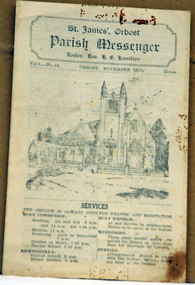
newsletter, St James, Orbost Parish Messenger November, 1933, November 1933
St. James' Anglican Church, Orbost, was conceived and built as a memorial to the men 'who served and suffered during the Great War' as noted on the foundation stone. The Right Reverend GH Cranswick, DD, Bishop of Gippsland, laid the stone on 1 October 1927. This parish newsletter was published regularly to inform church members of all the latest news, events and information.For many years the Anglican people of Orbost have enjoyed the fellowship of the church and the children, in particular, were socially and spiritually involved. This item is reminiscent of the first half of the 20th century when church-going was more common.A four page newsletter titled, Parish Messenger for Orbost, November 1933, Vol 6 -No 83. It lists the services, times, meetings and news. The rector at the time was Rev. K.E. Hamilton.st-james-anglican-church church newsletter -
 Whitehorse Historical Society Inc.
Map, Parish of Nunawading, 1853
Photocopy of manuscript map with allotments numbered and named.Photocopy of manuscript map with allotments numbered and named. Note on verso: Parish of Nunawading, County of Bourke. Gardiners Creek, Ballyshanassey Township, surveyed by H. Parmein, Surveyor General's office, Nov 30th 1853 [enlargement of ND2801, no list of corner references]Photocopy of manuscript map with allotments numbered and named. maps, gardiners creek, ballyshanassy, burwood east, parmein, h -
Whitehorse Historical Society Inc.
Map, The Parish of Nunawading, 1853
Photocopy of manuscript plan with allotments numbered and some named.Photocopy of manuscript plan with allotments numbered and some named. Note on verso: The Parish of Nunawading in the County of Bourke; lithographed at the Surveyor General's office by J.Jones Jan 18th 1853. Endorsed Sale Plan 271. Dray tracks, water holes and terrain indicated.Photocopy of manuscript plan with allotments numbered and some named. land subdivision, maps, parish of nunawading, jones, j -
 Whitehorse Historical Society Inc.
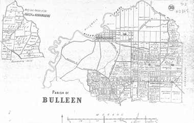
map, Parish of Bulleen, Not dated
A map on the parish of Bulleen.Parish of Bulleen with North East portion of the Parish of Nunawading [n.d. 1890's?]A map on the parish of Bulleen.shire of bulleen, shire of nunawading, land settlement -
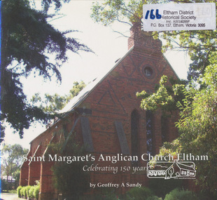 Eltham District Historical Society Inc
Book, Geoffrey A Sandy, Saint Margaret's Anglican Church Eltham by Geoffrey A Sandy, 2011
History of first 150 years of St Margaret's Anglican Parish Eltham24 p. : ill. (some col.), ports. ; 21 x 23 cm.ISBN 9780646562674 [signed by author on inside front cover and dated 17/11/11]st margaret's anglican parish -
 Warrnambool and District Historical Society Inc.
Documents Maps (3) - Warrnambool Town Allotments, City of W'bool Parish of Wangoom Country of Villiers, 1948
These maps were produced in 1948 and they contain maps of allotments within the city of Warrnambool, including the Central Business District, up to 1948. The details given on each allotment show the allotment and section numbers, the measurement in acres, the name of the original purchaser of the lot and the date of the first sale. The Warrnambool and District Historical Society owns several copies of these maps but these ones are originals.These three maps are of great significance because they give the names of land purchasers in Warrnambool from the date of the first land sales in 1847. They are a most valuable research tool and can be scanned and photocopied etc.These are three sheets of cream paper pasted on to linen. The sheets have black and white printing and map work. Some of the edges are a little frayed and there is some staining, particularly on the backs of the sheets.‘City of Warrnambool Parish of Wangoom County of Villiers Sheet 1’ ‘City of Warrnambool Parish of Wangoom County of Villiers Sheet 2’ ‘City of Warrnambool Parish of Wangoom County of Villiers Sheet 3’city of warrnambool, warrnambool maps, warrnambool town allotments 1948, land purchases -
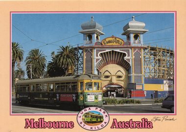 Melbourne Tram Museum
Postcard, Steve Parish Paddington Qld, SW6 940 outside Luna Park, late 1980's or early 1990's
Colour postcard cream border, divided back - Steve Parish postcard of SW6 940 outside Luna Park. Tram 940 in The Met colour scheme, possibly late 1980's or early 1990's with the destination of City, Route 16 with a Bank of Melbourne advert on the front. Back has space for name and address, stamp and a message and details of the postcard. Produced by Steve Parish Postcards. Card No. PC3021 Has "Melbourne Australia" along the bottom edge.trams, tramways, luna park, sw6 class, route 16, st kilda, tram 940 -
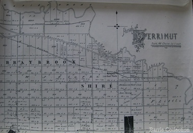 Melton City Libraries
Map, Parish of Derrimut, 1931
Map of the Parish of Derrimutcouncil -
Port Melbourne Historical & Preservation Society
Programme, St Joseph's Parish - Reopening of the Church, Sep 1999
Church and grounds were renovated in 1999, completed 4th September in time for the reopening service the following day. Hugh BROWN, Parish PriestProgram of service for the reopening of St Joseph's Catholic Church 5 Sept 1999. 16pp, cover cream and green with full colour representation of stained glass windowreligion - roman catholic church (st josephs), celebrations fetes and exhibitions, jim power, hugh brown, fred elliott, kay elliott, robert winduss, dianne drury, bill blackmore, jacqui o'callaghan, cellia carmody, joseph lynch, sally o'shannessy, norma sheehan, charlotte winduss, frances moore, paula elliot, ed mcdonnell, fiona mcdonnell, scott mcdonnell, brendan o'donnell, kate ryan, kate cleaves -
Port Melbourne Historical & Preservation Society
Document - Bulletin, St Joseph's Parish - Reopening of the Church, Sep 1999
Church and grounds were renovated in 1999, completed 4th September in time for the reopening service the following days. Hugh BROWN, Parish PriestChurch bulletin for the reopening of St Joseph's Catholic Church 5 Sept 1999. 4pp, light green insert in programreligion - roman catholic church (st josephs), celebrations fetes and exhibitions, jim power, hugh brown, fred elliott, kay elliott, robert winduss, dianne drury, bill blackmore, jacqui o'callaghan, cellia carmody, joseph lynch, sally o'shannessy, norma sheehan, charlotte winduss, frances moore, paula elliot, ed mcdonnell, fiona mcdonnell, scott mcdonnell, brendan o'donnell, kate ryan, kate cleaves -
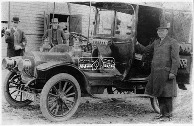 Eltham District Historical Society Inc
Negative - Photograph, The Roman Catholic Parish Priest, Eltham, c.1908
Man in top hat standing beside the car is most probably the Reverend John P. Carney (born 1880 Ballaghaderreen, Country Mayo, Ireland - ordained at All Hallows College, Dublin, Ireland) who spent all his years as a priest in the Melbourne Archdiocese, arriving in Melbourne in 1902. He was appointed Assistant priest at St Francis Melbourne then at Castlemaine and Gordon. He left Gordon to the pastor of the new mission at Diamond Creek where he spent about five years before moving to Footscray and later Yarraville. The automobile has been identified as a Unic Taxi built in the United Kingdom about 1908 though the actual date of this particular vehicle is unclear. The registration number 7788 was issued prior to 1910 at which point they changed to numerals only of the form nnn-nnn. Reproduced on p93 of 'Pioneers & Painters'.This photo forms part of a collection of photographs gathered by the Shire of Eltham for their centenary project book,"Pioneers and Painters: 100 years of the Shire of Eltham" by Alan Marshall (1971). The collection of over 500 images is held in partnership between Eltham District Historical Society and Yarra Plenty Regional Library (Eltham Library) and is now formally known as 'The Shire of Eltham Pioneers Photograph Collection'. It is significant in being the first community sourced collection representing the places and people of the Shire's first one hundred years.Digital image 120 format B&W negative Original sepia coloured postcard (10 x 15 cm) with cracking Black and white photograph duplicate (16.5 x 25 cm) with some corrections to mask cracksInscribed on reverse 'R.C. Parish Priest, Eltham'sepp, shire of eltham pioneers photograph collection, parish priest, automobile, john p carney, diamond creek, unic taxi, pioneers and painters, eltham, motor vehicles, rev. john p carney -
Stawell Historical Society Inc
Map, Parish of Stawell, Sheet 3, 1958
Parish of Stawell, Sheet 3stawell -
Stawell Historical Society Inc
Map, Parish of Stawell, Sheet 1
Parish of Stawell, Sheet 1stawell -
Stawell Historical Society Inc
Map, Parish of Stawell, Sheet 2, 1958
Parish of Stawell, Sheet 2stawell -
Stawell Historical Society Inc
Map, Parish of Stawell, Sheet 3, 1958
Parish of Stawell, Sheet 3stawell -
Stawell Historical Society Inc
Map, Parish of Stawell, Sheet 4, 1958
Parish of Stawell, Sheet 4stawell -
Stawell Historical Society Inc
Map, Parish of Stawell, Sheet 5, 1958
Parish of Stawell, Sheet 5stawell -
Stawell Historical Society Inc
Map, Parish of Mokepilly, County of Borung
Parish of Mokepilly, County of Borungstawell -
 Ringwood and District Historical Society
Map, Department of Mines, Plan of area applied for under the mining leases regulations in the township of Ringwood between Maroondah Highway and Mt. Dandenong Road. Mining District of Castlemaine, County of Mornington, Parish of Ringwood T Area 58(A) 2 (R)15(P) Acres, Roods, Perches. 1934, 20-Feb-34
Map of the township of Ringwood with subdivisions between Maroondah Highway and Mt. Dandenong Road. the area applied for on lease No.8210 by E.G.Browne.Mining District of Castlemaine, County of Mornington, Parish of Ringwood T Area 58(A) 2 (R)15(P) Acres, Roods, Perches.Buff coloured sheet foolscap with black printing showing map of the township of Ringwood between Maroondah Highway and Mt. Dandenong Road. Mining District of Castlemaine, County of Mornington, Parish of Ringwood T Area 58(A) 2 (R)15(P) Acres, Roods, Perches +Additional Keywords: Browne E.G. -
![Map, Plan of Subdivision of Crown Portion 23 & parts 24-25, Parish of Korkuperrimul [1900s?]](/media/collectors/5e461d8021ea67224c82f2a1/items/675fe058304668462205d4fb/item-media/675fe0ef304668462205d7d6/item-fit-380x285.jpg) Bacchus Marsh & District Historical Society
Bacchus Marsh & District Historical SocietyMap, Plan of Subdivision of Crown Portion 23 & parts 24-25, Parish of Korkuperrimul [1900s?]
The Parish of Korkuperrimul includes a significant section of the township of Bacchus Marsh and extends in western and northern directions from the township area. The date of the subdivision indicated on this plan has not been established. The engineer's stamp on the drawing shows the firm of Muntz and Muntz who were operating under that name in the early part of the 20th century.A single page paper map showing 20 blocks of land for sale in the Parish of Korkuperrimul. Scale 100 feet to 1 inch. The map is pasted into a bound volume containing 76 maps or plans in total. High resolution digital image stored on BMDHS computer network. Stamped: 'Muntz & Muntz Civil Engineers, Architects & Surveyors, Trustees Chambers ?? Cor Collins Street and Bank Placeland sales bacchus marsh, bacchus marsh victoria maps, land sales korkuperrimul parish -
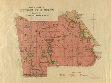 Federation University Historical Collection
Plan, Bungaree and Dean Parish and Geological Plan, 1890, 07/1890
Ferdinand M. Krause was a Professor at the Ballarat School of Mines.Geological and Parish Map of parts of the Parishes of Bungaree and Dean in the Counties of Talbot, Grenville and Grant. The scale is 40 chains to one inch. bungaree, deen, krause, f.m. krause, musk creek, clarkes hill, badger hill, beale's reservoir, acquainted. -
 Greensborough Historical Society
Maps, Greensborough. Parish Plan 1860, 1860c
This plan show Green's subdivision of Greensborough, north of Grimshaw Street.Enlargements of Parish plan circa 1860?One copy possibly from 1860, containing lot numbers for a government road, now Main Street, and surrounding streets.greensborough, grimshaw street greensborough, edward bernard green -
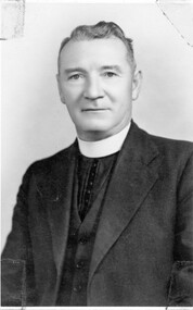 Linton and District Historical Society Inc
Photograph, Alex Wilkins, Warrnambool, Father Thomas Daly, parish priest at Linton
Father Thomas Daly died in 1954, and is buried in Linton cemetery.Black and white postcard photograph of a clean shaven man wearing suit and clerical collar."Parish Priest Linton Fr Daly buried at Linton".catholic priests, fr. thomas daly -
 Whitehorse Historical Society Inc.
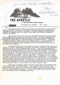
Document, The Apostle, 1979
A newsletter called The Apostle outlining the history of St. Thomas The Apostle Parish, Blackburn.non-fictionA newsletter called The Apostle outlining the history of St. Thomas The Apostle Parish, Blackburn.st. thomas the apostle catholic church blackburn, st. thomas the apostle primary school -
Whitehorse Historical Society Inc.
Article, Applause as new parish opens, n.d
Service to inaugurate St Alfred's as a parish after 20 years as part of Blackburn Parish,Service to inaugurate St Alfred's as a parish after 20 years as part of Blackburn Parish, attended by Archbishop of Melbourne, Rev Robert Dann.Service to inaugurate St Alfred's as a parish after 20 years as part of Blackburn Parish, st alfred's anglican church, blackburn north, dann, robert (rev) -
Stawell Historical Society Inc
Map, Great Western, Parish of Concongella, County of Borung, 1958
Great Western, Parish of Concongella, County of Borungstawell -
Stawell Historical Society Inc
Map, Township of Moyston, Parish of Moyston, County of Borung, 1956
Township of Moyston, Parish of Moyston, County of Borungstawell