Showing 190 items
matching property values
-
 Uniting Church Archives - Synod of Victoria
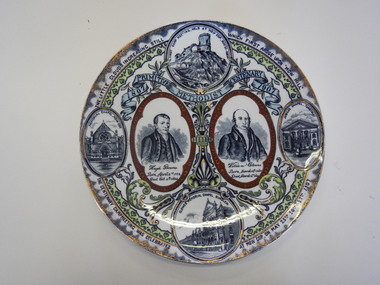
Commemorative Plate, 1907
... Schools 4,209. Teachers 61,275. Scholars 477,114. Value... Schools 4,209. Teachers 61,275. Scholars 477,114. Value ...In 1823 the membership of the Primitive Methodist church in the UK was 33,000. Forty years later, in 1863, membership had grown to half a million making it the third largest religious group after Anglican and Wesleyan Methodist. Primitive Methodism came to Australia in 1840. Source: https://www.movements.net/blog/2016/02/08/lessons-from-the-primitive-methodists-dave-price.htmlCH019.1 - Primitive Methodist white commemorative plate with grey, green, brown and gold illustrations and text. Images: Top: "First camp meeting, held at Mow Cop, May 31 1907". Right side: "Jubilee Chapel, Tunstall". Left side: "Memorial Chapel Mow Cop". Bottom:" Clowes Memorial Chapel, Burslem". Centre: "Hugh Bourne. Born April 3rd 1772. Died Oct 11th 1852" "William Cowes Born march 12th 1780 Died March 2nd 1858". The is text around the rim of the plate: "The little clouds increasing still which first arose upon Mow Hill" "The Centenary Camp Meeting was celebrated at Mow Cop on May 26th & 27th 1907". The back of the plate gives church statistics: "Truly What Hath God Wrought. Chapels & Preaching places 4,905. Ministers 1,153. Local Preachers 16,209. Church Members 210,173. Congregational ... 607,682. Sunday Schools 4,209. Teachers 61,275. Scholars 477,114. Value of Property 4,958,978 pounds. CH019.2 - Same as CH019.1 in white, blue and gold. CH019.3 - Same as CH019.1 with more gold and colour. The wording around the rim is the same but differently placed."1807 PRIMITIVE METHODIST CENTENARY 1907"primitive methodist, primitive methodist jubliee chapel tunstall, mow cop, bourne, hugh, clowes, william -
 Eltham District Historical Society Inc
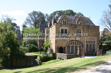
Photograph - Digital Photograph, Alan King, Great Hall, Montsalvat, 8 January 2008
... into a trust to benefit the Victorian people. The property... into a trust to benefit the Victorian people. The property ...Great Hall at Montsalvat built 1938-52, designed by Justus Jorgensen Covered under National Estate, National Trust of Australia (Victoria) State Significance, Victorian Heritage and Heritage Overlay, Nillumbik Planning Scheme. Published: Nillumbik Now and Then / Marguerite Marshall 2008; photographs Alan King with Marguerite Marshall.; p129 At first glance, Montsalvat, the artists’ community at Hillcrest Avenue, Eltham, could belong to another time and place. The French provincial Gothic-style buildings blend picturesquely with the introduced and native trees and farm animals on the five hectare property. But Montsalvat belongs very much to today’s Eltham, having inspired much of its creative activity and style. The use of mud-brick and recycled building materials, for which Eltham is so well-known, was largely popularised by Montsalvat. Montsalvat – unique in Victoria and probably in Australia – is registered by the National Trust and National Estate.1 Montsalvat, named after the castle of the Knights of the Holy Grail, has attracted artists and intellectuals since it was founded in 1934. For years at weekends, artists, lawyers, philosophers, politicians and others, who shared a love for what Montsalvat stood for, gathered for a meal and stimulating discussion. The focus for this gathering of talent was Justus Jörgensen, an eccentric man with vision and charisma. It was Jörgensen’s foresight that saw the creation of Montsalvat, which in 1975 was formed into a trust to benefit the Victorian people. The property was then valued at about three million dollars. It is now visited by thousands of people annually. Born in 1894 and brought up a Catholic, Jörgensen had trained as an architect. He later studied painting at the National Gallery School under artist, Frederick McCubbin, then joined the studio of artist Max Meldrum. In 1924, Jörgensen married medical student Lillian Smith, and with artist friends they travelled to Europe to study the great masters. In London Jörgensen exhibited in several major galleries. One of his still life paintings was included in the book The Art of Still Life by Herbert Furst, which featured 100 of the greatest ever still life paintings.2 In 1929, Jörgensen returned to Melbourne where Lil, now qualified, worked as an anaesthetist at St Vincent’s Hospital. They bought a small house in Brighton and Jörgensen rented a large building in Queen Street for his studio until the Royal Automobile Club of Victoria bought it in 1955. While designing and overseeing the building of a studio for his friend the famous cartoonist Percy Leason, in Lavender Park Road, Jörgensen decided to buy land for a country retreat in Eltham. So the building of Montsalvat began. Jörgensen gathered around a dozen of his friends and students from his Queen Street studio. They set to work, first at weekends then some decided to live permanently on the site. Jörgensen had seen mud-brick buildings in Spain and recognised that Eltham’s clay soil was ideal for mud-bricks and although labour intensive, it was a very cheap way of building. Jörgensen’s students and friends worked under his direction with the help of local tradesmen, including carpenter, Len Jarrold and later stone mason, Horrie Judd. In return Jörgensen would give the students a painting lesson or two. It was the Great Depression when many were out of work. Jörgensen also inspired people to give generously of money and materials. With their help Jörgensen found second-hand materials for building. Friends donated slate for roofing, discarded firebricks were used for flooring and windows and doors and a cast-iron circular staircase came from a wrecker. The students’ day started at 7am with building and domestic chores, shared equally between the sexes. The first building was used by his friends at weekends and then became a home for his wife Lil. It consisted of three rooms and an attic under a high-pitched roof. Jörgensen then built a similar structure with the same high-pitched roof as a more permanent home for his students. The two buildings were joined together with a tower and a studio for Jörgensen. While excavating for the studio a reef of yellow mud-stone was found and then used in construction. The next building was the Great Hall, to be used for dining, exhibitions and meetings and completed in 1958, after a halt during the war. Whelan the Wrecker donated the stone-framed windows from the building that housed the Victorian Insurance Co. in Collins Street, which had been demolished in the 1930s. The swimming pool was donated and cubicles were built for the students with their initials marked in tiles on each doorstep.1 One of Jörgensen’s great abilities was to recognise how to use material which harmonised. He would comb through wreckers’ yards for what he needed. Regarding his buildings as sculptural pieces, his first consideration was for the aesthetic quality of a building and only then for its functionality.2 At Montsalvat, Jörgensen found he was able to put his ideas into practice without compromise and those who worked with him had to conform to his ideas. With the Jörgensens, the colony’s original nucleus consisted of the Skipper family – Mervyn and wife Lena, daughters Helen and Sonia and son Matcham,who was to become an eminent jeweller and sculptor represented in National Gallery collections throughout Australia and in European museums.3 Other members were Arthur Munday, Lesley Sinclair, Helen Lempriere, Ian Robertson, John Smith, George Chalmers, John Busst and Sue Van der Kellan; also Jörgensen’s three sons – Max, Sebastian and Sigmund – and Saskia, Sonia Skipper and Arthur Munday’s daughter. Montsalvat went through some hard times when local gossips spread rumours of sexual shenanigans at Montsalvat. However Montsalvat also had many local supporters – especially amongst the local tradespeople. The colony was certainly unconventional – with Jörgensen’s wife Lil (and son Max) and life-time partner Helen Skipper, (mother of Sebastian and Sigmund) living at Montsalvat. Sonia Skipper says in her biography that the group were ‘very conscious of their responsibilities to each other and a desire to make their relationships work’.4 By World War Two many buildings around the Great Hall were completed. Jörgensen was a pacifist, as were most of his students. Some of the Montsalvat community enlisted while others engaged in essential services like dairy farming and market gardening for the war effort. It was then that Jörgensen constructed farm buildings. After the war many well-known personalities such as Clifton Pugh, landscape gardener Gordon Ford, and builder Alistair Knox, were drawn to Montsalvat. They learnt that building was not a ‘sacred cow’ only for professionals, but that anyone who was willing to get their hands dirty could do it. The post-war shortage of materials also encouraged builders to follow Montsalvat’s lead in reusing materials. When Jörgensen died in 1975, his influence did not – thanks largely to the vigilance of his son, Sigmund, who became its administrator. The weekend dinners have gone, but in 2008 about 14 artists still work at Montsalvat – some living there – including a couple who have been there since its early days. Under Sigmund’s direction Montsalvat further expanded its activities which included festivals, art exhibitions, concerts and weddings. Sigmund completed the Chapel, then the Long Gallery next to the pool, After the barn burnt down, he replaced it in 1999 (the builder was Hamish Knox, Alistair’s son) with a new gallery and entrance and added a restaurant. Sigmund has been careful that any new building blends in with the character of Montsalvat. In 2006 Montsalvat was restructured for its continued financial viability and with the help of Arts Victoria a new executive officer was appointed. A representative board from the wider community was established, which includes members from the former Montsalvat Trust including Sigmund Jörgensen – who is now the heritage and arts adviser to the new company Montsalvat Ltd.5 Today, visiting Montsalvat one still sees artists, students and visitors enjoying the unique and beautiful surroundings.This collection of almost 130 photos about places and people within the Shire of Nillumbik, an urban and rural municipality in Melbourne's north, contributes to an understanding of the history of the Shire. Published in 2008 immediately prior to the Black Saturday bushfires of February 7, 2009, it documents sites that were impacted, and in some cases destroyed by the fires. It includes photographs taken especially for the publication, creating a unique time capsule representing the Shire in the early 21st century. It remains the most recent comprehenesive publication devoted to the Shire's history connecting local residents to the past. nillumbik now and then (marshall-king) collection, eltham, great hall, montsalvat -
 Ballan Shire Historical Society
Map - Map. Korweinguboora, Department of Lands and Survey, Korweinguboora. Counties of Talbot and Grant
A map of the Korweinguboora area showing roads, forests, railway lines and properties with the owners names.The inclusion of the names of landowners is of significance and value to historians.A map of the Korweinguboora area showing land subdivisions and names of owners and other physical features. There is a scale in chains. No date is certain but it could be 1902. The map has been repaired with sellotape.There are various pencil annotations but the are difficult to read.talbot, moorarbool west, wombat, bullarto, korweinguboora, moorarbool east, dean, wombat state forest, barkstead -
 Flagstaff Hill Maritime Museum and Village
Functional object - Copper Sheet, circa 1878
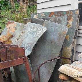
In 1984 the Commonwealth Government made available to Flagstaff Hill a collection of lead ingots and copper sheets recovered from the wreck-site of the LOCH ARD. They were presented to the Warrnambool City Council by the Hon. Tom Uren MHR, Minister for Territories and Local Government: “The Commonwealth recognises that shipwrecks like the LOCH ARD are our national heritage with important educational, recreational and tourist applications” (The Standard, Tuesday 8 May 1984). The LOCH ARD was wrecked in 1878. Unsuccessful salvage operations were then undertaken with the 90 ton paddle steamer NAPIER. In sudden bad weather this vessel too was sunk. The precise position of the LOCH ARD in the exposed and dangerous waters off Mutton Bird Island became lost to memory. The underwater location of the LOCH ARD was rediscovered in 1967 by a Warrnambool skindiver, Stan McPhee. In the two years following his find, the vessel was systematically pillaged by unauthorised salvagers. This led to the State and Federal Governments’ intervention in 1969. A roundup and seizure of recovered lead ingots and copper sheets was conducted by Commonwealth and Victorian Police. Offenders were charged and convicted. The “repossessed loot of the Tassie Boys” was placed into secure storage (Jack Loney, 1978, Wrecks & Reputations). The LOCH ARD manifest of cargo lists “Pig lead 50 tons, 994 pig & 37 rolls” and “Copper 33 plates, 53 bolts”. While the lead ingots have been subsequently described as “ballast”, the copper sheets are unlikely to have been associated with the ship’s normal complement in that way. Similar product lines in the cargo manifest are “Bar and rod iron 102 tons”, “Plate iron 3 tons” and “Zinc 12 tons”. These raw materials were used by colonial artisans such as blacksmiths and metal smelters to fashion, and repair, agricultural implements and industrial machinery. Copper was valued for its non-corrosive properties and its malleability, or ease of working. Both these qualities were useful, for example, in laying underground gas pipes that supplied lighting to residences, businesses and streetscapes in the mid-nineteenth century. As the nineteenth century progressed, the metal was also increasingly valued for its conductivity, with copper wiring linking colonial communities to each other, and the wider world, via the Telegraph system. The average weight of the copper sheets is 216 kilograms, calculated by "volume 0.1936m³ X Cu density 8930kgs/m³".The shipwreck of the Loch Ard is of significance for Victoria and is registered on the Victorian Heritage Register ( S 417). Flagstaff Hill has a varied collection of artefacts from Loch Ard and its collection is significant for being one of the largest accumulation of artefacts from this notable Victorian shipwreck. The collections object is to also give us a snapshot into history so we can interpret the story of this tragic event. The collection is also archaeologically significant as it represents aspects of Victoria's shipping history that allows us to interpret Victoria's social and historical themes of the time. The collections historically significance is that it is associated unfortunately with the worst and best-known shipwreck in Victoria's history. Large heavy sheets or panels of copper metal raised from the wreck of the LOCH ARD. The 10 sheets are of roughly similar dimensions and rectangular shape. They bear signs of prolonged submersion in seawater, with various degrees of limestone accretion, adhered marine growth, and green oxidisation. Three of the sheets are severely buckled, demonstrating the force of underwater explosives used in their salvage. One sheet appears cut or severed in a diagonal line downwards from its top left hand corner. One sheet has a 10cm X 10cm square cut out of its top right hand corner. All sheets are in sturdy, stable condition. No maker’s marks are visible.flagstaff hill, warrnambool, shipwrecked coast, flagstaff hill maritime museum, flagstaff hill maritime village, great ocean road, loch line, loch ard, captain gibbs, eva carmichael, tom pearce, glenample station, mutton bird island, loch ard gorge, sailing ship, copper sheet, manutacturing materials, metal imports, muntz -
 Flagstaff Hill Maritime Museum and Village
Functional object - Lead Ingot, circa 1878
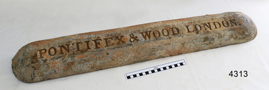
This lead ingot was donated to Flagstaff Hill Maritime Village in January 2015 by local residents who discovered the ingot in their garden after they purchased the property about 12 months ago The LOCH ARD cargo manifest lists “Pig lead 50 tons” comprising “944 pig and 37 rolls”. Subsequent classification has rendered this section of cargo as “Lead Ballast”. This could be true. The international price per ton of lead ore plunged from a high point of £17 in 1853 to a low of £8 in 1882. The cheaper price of lead at the time of the vessel’s loading in early 1878 may have meant it was considered as an alternative to other ballast material (traditionally stone) for the journey to Melbourne. Loch Line ships generally returned to Britain laden with Australian wool. Even though wool bales were “screwed in” to the hold to less than half their “pressed weight”, they still made an awkwardly light cargo for the passage around the Horn. The concentrated weight of lead pigs along the keel line would help steady and centre the ship, and perhaps the artefacts in this case were to be retained for this purpose, rather than being sold on to the ready colonial market. However this is conjecture. Demand for building materials in the gold and wool rich Colony of Victoria was high in the 1870s, and much of the LOCH ARD cargo was intended for the Melbourne International Exhibition in 1880, which was another example of buoyant economic conditions. In the nineteenth century lead was valued for its density (high ratio of weight to volume), flexibility (relative softness for working into shape), and durability (corrosion resistant and waterproofing properties). It was used for pipes and water tanks, roof flashing and guttering, window sealing and internal plumbing. Many large private residences and new public buildings were at planning or construction stage in the colony during this period. The LOCH ARD lead ingots could equally have been destined for this ready market. HISTORY OF THE LOCH ARD The LOCH ARD belonged to the famous Loch Line which sailed many ships from England to Australia. Built in Glasgow by Barclay, Curdle and Co. in 1873, the LOCH ARD was a three-masted square rigged iron sailing ship. The ship measured 262ft 7" (79.87m) in length, 38ft (11.58m) in width, 23ft (7m) in depth and had a gross tonnage of 1693 tons. The LOCH ARD's main mast measured a massive 150ft (45.7m) in height. LOCH ARD made three trips to Australia and one trip to Calcutta before its final voyage. LOCH ARD left England on March 2, 1878, under the command of Captain Gibbs, a newly married, 29 year old. She was bound for Melbourne with a crew of 37, plus 17 passengers and a load of cargo. The general cargo reflected the affluence of Melbourne at the time. On board were straw hats, umbrella, perfumes, clay pipes, pianos, clocks, confectionary, linen and candles, as well as a heavier load of railway irons, cement, lead and copper. There were items included that intended for display in the Melbourne International Exhibition in 1880. The voyage to Port Phillip was long but uneventful. At 3am on June 1, 1878, Captain Gibbs was expecting to see land and the passengers were becoming excited as they prepared to view their new homeland in the early morning. But LOCH ARD was running into a fog which greatly reduced visibility. Captain Gibbs was becoming anxious as there was no sign of land or the Cape Otway lighthouse. At 4am the fog lifted. A man aloft announced that he could see breakers. The sheer cliffs of Victoria's west coast came into view, and Captain Gibbs realised that the ship was much closer to them than expected. He ordered as much sail to be set as time would permit and then attempted to steer the vessel out to sea. On coming head on into the wind, the ship lost momentum, the sails fell limp and LOCH ARD's bow swung back. Gibbs then ordered the anchors to be released in an attempt to hold its position. The anchors sank some 50 fathoms - but did not hold. By this time LOCH ARD was among the breakers and the tall cliffs of Mutton Bird Island rose behind the ship. Just half a mile from the coast, the ship's bow was suddenly pulled around by the anchor. The captain tried to tack out to sea, but the ship struck a reef at the base of Mutton Bird Island, near Port Campbell. Waves broke over the ship and the top deck was loosened from the hull. The masts and rigging came crashing down knocking passengers and crew overboard. When a lifeboat was finally launched, it crashed into the side of LOCH ARD and capsized. Tom Pearce, who had launched the boat, managed to cling to its overturned hull and shelter beneath it. He drifted out to sea and then on the flood tide came into what is now known as LOCH ARD Gorge. He swam to shore, bruised and dazed, and found a cave in which to shelter. Some of the crew stayed below deck to shelter from the falling rigging but drowned when the ship slipped off the reef into deeper water. Eva Carmichael had raced onto deck to find out what was happening only to be confronted by towering cliffs looming above the stricken ship. In all the chaos, Captain Gibbs grabbed Eva and said, "If you are saved Eva, let my dear wife know that I died like a sailor". That was the last Eva Carmichael saw of the captain. She was swept off the ship by a huge wave. Eva saw Tom Pearce on a small rocky beach and yelled to attract his attention. He dived in and swam to the exhausted woman and dragged her to shore. He took her to the cave and broke open case of brandy which had washed up on the beach. He opened a bottle to revive the unconscious woman. A few hours later Tom scaled a cliff in search of help. He followed hoof prints and came by chance upon two men from nearby Glenample Station three and a half miles away. In a state of exhaustion, he told the men of the tragedy. Tom returned to the gorge while the two men rode back to the station to get help. By the time they reached LOCH ARD Gorge, it was cold and dark. The two shipwreck survivors were taken to Glenample Station to recover. Eva stayed at the station for six weeks before returning to Ireland, this time by steamship. In Melbourne, Tom Pearce received a hero's welcome. He was presented with the first gold medal of the Royal Humane Society of Victoria and a £1000 cheque from the Victorian Government. Concerts were performed to honour the young man's bravery and to raise money for those who lost family in the LOCH ARD disaster. Of the 54 crew members and passengers on board, only two survived: the apprentice, Tom Pearce and the young woman passenger, Eva Carmichael, who lost all of her family in the tragedy. Ten days after the LOCH ARD tragedy, salvage rights to the wreck were sold at auction for £2,120. Cargo valued at £3,000 was salvaged and placed on the beach, but most washed back into the sea when another storm developed. The wreck of LOCH ARD still lies at the base of Mutton Bird Island. Much of the cargo has now been salvaged and some was washed up into what is now known as LOCH ARD Gorge. Cargo and artefacts have also been illegally salvaged over many years before protective legislation was introduced. One of the most unlikely pieces of cargo to have survived the shipwreck was a Minton porcelain peacock - one of only nine in the world. The peacock was destined for the Melbourne International Exhibition in 1880. It had been well packed, which gave it adequate protection during the violent storm. Today, the Minton peacock can be seen at the Flagstaff Hill Maritime Museum in Warrnambool. From Australia's most dramatic shipwreck it has now become Australia's most valuable shipwreck artefact and is one of very few 'objects' on the Victorian State Heritage Register. The shipwreck of the LOCH ARD is of State significance ― Victorian Heritage Register S417 Flagstaff Hill’s collection of artefacts from LOCH ARD is significant for being one of the largest collections of artefacts from this shipwreck in Victoria. It is significant for its association with the shipwreck, which is on the Victorian Heritage Register (VHR S417). The collection is significant because of the relationship between the objects, as together they have a high potential to interpret the story of the LOCH ARD. The LOCH ARD collection is archaeologically significant as the remains of a large international passenger and cargo ship. The LOCH ARD collection is historically significant for representing aspects of Victoria’s shipping history and its potential to interpret sub-theme 1.5 of Victoria’s Framework of Historical Themes (living with natural processes). The collection is also historically significant for its association with the LOCH ARD, which was one of the worst and best known shipwrecks in Victoria’s history. Lead ingots (sometimes referred to as ‘lead ballast’ or ‘lead pigs), salvaged from the wreck of the LOCH ARD. Grey metal bars with flat base, rising in a curved moulded shape to form a smooth rounded upper face. The imprint of the maker runs along the upper surface in clearly legible capital lettering (height 3cm). Durable and heavy, with some marine staining, but in good condition. Stamped along curved surface, within oval border, "PONTIFEX & WOOD LONDON."flagstaff hill, warrnambool, shipwrecked coast, flagstaff hill maritime museum, maritime museum, shipwreck coast, flagstaff hill maritime village, great ocean road, loch line, loch ard, captain gibbs, eva carmichael, tom pearce, glenample station, mutton bird island, loch ard gorge, lead pigs, lead ingots, lead ballast, pontifex and wood, london, lead smelters -
 Warrnambool and District Historical Society Inc.
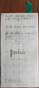
Document - Richard Bright Probate 1897, 1897
This document contains the Probate Papers following the death of Richard Bright, a Warrnambool stonemason who died in August 1897. No other information has been found on Richard Bright but he must have been a successful tradesman as he left real estate to the value of £680 and personal estate to the value of £94. His executors were his son, Daniel Bright of Terang and the law clerk, Thomas Goodall. Richard Bright left a number of properties to his wife, Elizabeth, his sons, Daniel and John and his daughters, Adelaide Scown and Martha Head. This document was in the possession of Thomas Goodall , a law clerk managing the Ernest Chambers legal offices in Warrnambool and it was eventually passed on to the law firms operating from the same premises in Kepler Street. It was handed to the Historical Society when it was found in the premises once occupied by the law firm of Mackay Taylor. Tait collection: item 14 of 62This document is of interest as it originally was drawn up by a local lawyer. Ernest Chambers, and the probate papers are for a local Warrnambool resident, Richard Bright. This is a piece of parchment paper, folded in two, with handwriting on all pages. There is a seal of the Supreme Court of the Colony of Victoria attached with a green ribbon and a red stamp of the Master in Equity of the Supreme Court. There are ruled black lines on three pages and pencilled writing in the margin of the first page. Some of the writing is a little faded. ‘In the Supreme Court of the Colony of Victoria, In the Probate Jurisdiction In the Will of Richard Bright, late of Warrnambool in the Colony of Victoria, Mason, deceased. Probate. I certify that no duty is payable herewith. J. Poole, Officer under Sec. 96, Act 1060, 16/11/97. E.J.W. Chambers, Proctor, Warrnambool’ernest chambers, thomas goodall richard bright, richard bright, tait collection -
 Kiewa Valley Historical Society
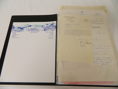
Folder - Retail Development of Mt Beauty
... . This enables researchers to gauge the value of the properties ...The papers have been collected in correspondence since 1947 and cover many of the retail shops in Mt Beauty. The sale of the shops by the State Electricity Commission during the 1960's when the construction of the Kiewa Hydro Electric Scheme was completed. Owners of the Mt Beauty Supermart and Newsagency and Falls Creek Mini-Mart, Samuel Keith Pearce and Gordon Cathew Pearce's documents are included. The papers record a period when the SECV sold the retail shops in Mt Beauty after the completion of the Kiewa Hydro Electric Scheme. This enables researchers to gauge the value of the properties at the time and the changes in retail shops from that time.A black plastic folder containing a collection of correspondence pertaining to the retail development of Mt Beauty from the 1940's through to the 1960's and 1970's. pearce bros. mt beauty. falls creek. mt beauty retail. state electricity commission of victoria. -
 Warrnambool and District Historical Society Inc.
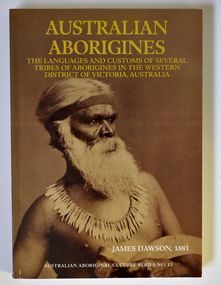
Book - Book of Early Western District Aboriginal Languages and Culture, Griffin Press Limited. South Australia, Australian Aborigines, 1981
Description of Western District Aborigines and a dictionary of three of their languagesThis is a book of 112 pages of text plus 104 pages of aboriginal words and their meanings. The green cover has a gold image of an aboriginal hunter on the front cover and gold printing and a floral image on the spine. The pages contain printed text and some sepia-coloured photographs. non-fictionDescription of Western District Aborigines and a dictionary of three of their languagesjames dawson's book 'australian aborigines', western district aborigines 19th century -
 Warrnambool and District Historical Society Inc.
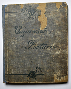
Album - Album with Cigarette Cards, Edwards Family, Cigarettes Pictures, 1908
This album contains cigarette cards dating from the early 20th Century. The cards include Australian and English cricketers, Australian footballers, animals, racehorses, ships, Pacific Islanders, jockeys, actors and other famous people. The cards come from a variety of Australian and English cigarette companies. The album comes from the Edwards family who lived on the MORVEN property situated about 11 kilometres west of Branxholme in the Western District of Victoria. This property was sub divided in 1911 into 25 farms. There was once a Morven School and today there is a road of that name in the area.. This album is of considerable significance as it has historical value as an early collection of cigarette cards. Collecting of cigarette cards was a major social activity amongst young people, particularly in the first half of the 20th Century. It was a profitable advertising ploy for cigarette companies. Card and small object collecting by children today is still popular and used as an advertising mechanism. This album has a worn cover in faded green and fawn colours with a blue spine almost wholly detached. The back cover is stained. The cover has text. There are eighteen double sided pages with cut spaces for holding seven cigarette cards on each. Most of the pages contain black and white, sepia or coloured cigarette cards. There is an inscription on the first page.To Bennie from Auntie Lou. Xmas 1908cigarette cards, morven, edwards family morven, album -
 Eltham District Historical Society Inc
Photograph, Liz Pidgeon, Public Records Office Victoria (PROV) visit to Eltham Justice Precinct, 20 Apr 2018
The original Shire of Eltham was founded in 1871. Prior to its founding, the district was managed by the Eltham District Road Board, which was established in 1856. The initial rate assessment commenced in 1857 for the year ending October 14, 1858. The honour of being recorded with the first assessment went to a farm of 110 cultivated acres at Lower Plenty, owned by John Porter and occupied by Albert Baines. It was assessed at 6d/acre providing for a rate income of £2 15s. In July 2017, officers at Nillumbik Shire Council discovered some early Eltham Road District Assessment books and donated them to the Eltham District Historical Society. The seven volumes were the district’s first six years of rate assessments. This was a unique and significant record of early settlers in the pre-Shire of Eltham. They immediately became one of the oldest and most valuable items in our collection. An article on page 5 in the Eltham and Whittlesea Shires Advertiser, Friday, 21 November, 1941 titled: ‘District’s Early History‘ states: “The first rate book which is still in existence at the Shire Office is for the year ending October 14, 1858 and is probably the best record possible to indicate the development of the district. At the time properties were rated as follows: Cultivated land. 6d. per acre; pasture land, 1d. per acre: estimated annual value of buildings, etc., 6d in the (pound). The total amount of rate recorded for the year was £153/14/8. Properties were described as being situated at Lower Plenty, Yarra Yarra, Eltham, Lower Eltham, Kangaroo Ground, Yarra Flats, Diamond Creek and the Yarra.” Given the precious nature of this collection, priority was given to digitise the rate books and place them in suitable archival storage to minimise further handling. Subsequent discussion amongst our Collections team arrived at the conclusion that the most appropriate home for this valuable record was the Public Record Office Victoria (PROV), the archive of the State Government of Victoria and who are charged with archiving and caring for all Government related records. An approach was made to PROV who confirmed these records would complete their collection of rate assessment books for Eltham. At a small ceremony held Friday, April 20 at the Local History Centre, Eltham, members of the Society and our Collections team, along with Ms. Vicki Ward, MP for Eltham, presented the seven volumes for 1858-1863 along with the complete set of digital files to Mr. David Taylor, Community Archives Manager and Mr. Charlie Farrugia, Senior Collection Advisor, Public Record Office Victoria.Born Digitalassessment ledger, donation, eltham courthouse, eltham road district, local history centre, public records office victoria (prov), rate books, eltham district road board -
 Eltham District Historical Society Inc
Photograph - Colour Print, Belle Vue, Livingstone Road, Eltham, c.2015
Belle Vue property in Livingstone Road, Eltham was once owned by Society member Jo McCormick. Jo was a valued member of our committee and dear friend of many of our members until her death in 2009. Belle Vue is the farmhouse of a property that is now a significant part of suburban Eltham, just a short distance north of the town centre. Originally purchased by pioneer Eltham farmer Henry Stooke, the present-day old farmhouse sits within an extensive suburban residential area. The history of the property is largely based on a heritage assessment prepared by consultant Lorraine Huddle for Nillumbik Shire Council. Additional information from our Society records reveals Belle Vue farm comprised about 56 ha (140 acres) extending northerly from the northern boundary of Holloway’s 1851 Little Eltham subdivision. On the present day map the southern boundary was just north of Elsa Court and Grove Street. The western boundary was the Diamond Creek and extended northerly to Main Road where it turns easterly towards Research. It was traversed by the main road to Kangaroo Ground and beyond and from 1912 by the railway to Hurstbridge. From 1895 the farm was owned by William Williams and his wife Mary Ann. In 1914 -15 they built a new house now known as Belle Vue. They sold the land in 1920 and residential subdivision began soon after that. Belle Vue remains today on a substantially subdivided and very much reduced size residential lot in Livingstone Road. The house and many old trees on the site were subject to a heritage overlay under the Nillumbik Planning Scheme. Despite that overlay, the development and subdivision of the original land resulted in most of the heritage listed trees being removed. belle vue, eltham, livingstone road -
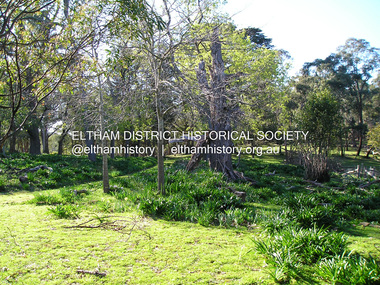
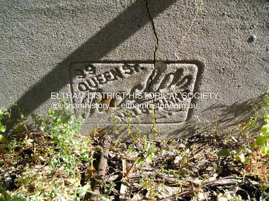
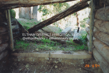 Eltham District Historical Society Inc
Photograph, Fay Bridge, Former Morrison property, Killeavey, Laughing Waters Road, Eltham, 28 June 2004
Beatrice Wanliss Irvine was the daughter of former Victorian Premier Sir William Irvine. From age 13 she lived at “Killeavey” off Laughing Waters Road (later accessed from Reynolds Road). In 1923 she married James Morrison and the couple received Killeavey as a wedding gift. The property supported fruit and vegetable growing as well as an impressive botanical garden. But James died in 1936 after a period of ill health, leaving Beatrice to support their six children. The Killeavey house was built atop a cliff, 40 metres above the Yarra River. The garden was designed in 1910 by William Guilfoyle who was the second director of the Royal Botanical Gardens. The house was totally destroyed in the Black Friday bushfires in 1939, but was rebuilt. Beatrice continued to live at Killeavey and became well regarded as a botanist and naturalist. She died in 1989 and is buried in Eltham Cemetery with her husband and one of their sons. The (rebuilt) house was demolished by Parks Victoria. It contains significant garden remnants. The surrounding bushland is valued for its significant plant communities.fay bridge collection, 2004-06-28, beatrice wanliss morrison (nee irvine), eltham, james morrison, killeavey, laughing waters road, william irvine -
 Eltham District Historical Society Inc
Photograph, Fay Bridge, Former Morrison property, Killeavey, Laughing Waters Road, Eltham, 30 August 2019
Beatrice Wanliss Irvine was the daughter of former Victorian Premier Sir William Irvine. From age 13 she lived at “Killeavey” off Laughing Waters Road (later accessed from Reynolds Road). In 1923 she married James Morrison and the couple received Killeavey as a wedding gift. The property supported fruit and vegetable growing as well as an impressive botanical garden. But James died in 1936 after a period of ill health, leaving Beatrice to support their six children. The Killeavey house was built atop a cliff, 40 metres above the Yarra River. The garden was designed in 1910 by William Guilfoyle who was the second director of the Royal Botanical Gardens. The house was totally destroyed in the Black Friday bushfires in 1939, but was rebuilt. Beatrice continued to live at Killeavey and became well regarded as a botanist and naturalist. She died in 1989 and is buried in Eltham Cemetery with her husband and one of their sons. The (rebuilt) house was demolished by Parks Victoria. It contains significant garden remnants. The surrounding bushland is valued for its significant plant communities.fay bridge collection, beatrice wanliss morrison (nee irvine), eltham, james morrison, killeavey, laughing waters road, william irvine, 2019-08-30 -
 Eltham District Historical Society Inc
Photograph, Fay Bridge, Former Morrison property, Killeavey, Laughing Waters Road, Eltham, 27 October 2019
Beatrice Wanliss Irvine was the daughter of former Victorian Premier Sir William Irvine. From age 13 she lived at “Killeavey” off Laughing Waters Road (later accessed from Reynolds Road). In 1923 she married James Morrison and the couple received Killeavey as a wedding gift. The property supported fruit and vegetable growing as well as an impressive botanical garden. But James died in 1936 after a period of ill health, leaving Beatrice to support their six children. The Killeavey house was built atop a cliff, 40 metres above the Yarra River. The garden was designed in 1910 by William Guilfoyle who was the second director of the Royal Botanical Gardens. The house was totally destroyed in the Black Friday bushfires in 1939, but was rebuilt. Beatrice continued to live at Killeavey and became well regarded as a botanist and naturalist. She died in 1989 and is buried in Eltham Cemetery with her husband and one of their sons. The (rebuilt) house was demolished by Parks Victoria. It contains significant garden remnants. The surrounding bushland is valued for its significant plant communities.fay bridge collection, beatrice wanliss morrison (nee irvine), eltham, james morrison, killeavey, laughing waters road, william irvine, 2019-10-27 -
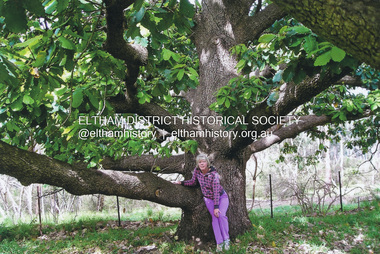
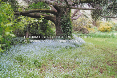 Eltham District Historical Society Inc
Photograph, Fay Bridge, New Zealand Oak at former Morrison property, Killeavey, Laughing Waters Road, Eltham, n.d
Beatrice Wanliss Irvine was the daughter of former Victorian Premier Sir William Irvine. From age 13 she lived at “Killeavey” off Laughing Waters Road (later accessed from Reynolds Road). In 1923 she married James Morrison and the couple received Killeavey as a wedding gift. The property supported fruit and vegetable growing as well as an impressive botanical garden. But James died in 1936 after a period of ill health, leaving Beatrice to support their six children. The Killeavey house was built atop a cliff, 40 metres above the Yarra River. The garden was designed in 1910 by William Guilfoyle who was the second director of the Royal Botanical Gardens. The house was totally destroyed in the Black Friday bushfires in 1939, but was rebuilt. Beatrice continued to live at Killeavey and became well regarded as a botanist and naturalist. She died in 1989 and is buried in Eltham Cemetery with her husband and one of their sons. The (rebuilt) house was demolished by Parks Victoria. It contains significant garden remnants. The surrounding bushland is valued for its significant plant communities.fay bridge collection, beatrice wanliss morrison (nee irvine), eltham, james morrison, killeavey, laughing waters road, william irvine, new zealand oak -
 Eltham District Historical Society Inc
Photograph, Fay Bridge, Fay Bridge with New Zealand Oak at former Morrison property, Killeavey, Laughing Waters Road, Eltham, n.d
Beatrice Wanliss Irvine was the daughter of former Victorian Premier Sir William Irvine. From age 13 she lived at “Killeavey” off Laughing Waters Road (later accessed from Reynolds Road). In 1923 she married James Morrison and the couple received Killeavey as a wedding gift. The property supported fruit and vegetable growing as well as an impressive botanical garden. But James died in 1936 after a period of ill health, leaving Beatrice to support their six children. The Killeavey house was built atop a cliff, 40 metres above the Yarra River. The garden was designed in 1910 by William Guilfoyle who was the second director of the Royal Botanical Gardens. The house was totally destroyed in the Black Friday bushfires in 1939, but was rebuilt. Beatrice continued to live at Killeavey and became well regarded as a botanist and naturalist. She died in 1989 and is buried in Eltham Cemetery with her husband and one of their sons. The (rebuilt) house was demolished by Parks Victoria. It contains significant garden remnants. The surrounding bushland is valued for its significant plant communities.fay bridge collection, beatrice wanliss morrison (nee irvine), eltham, james morrison, killeavey, laughing waters road, william irvine, new zealand oak, fay bridge -
 Eltham District Historical Society Inc
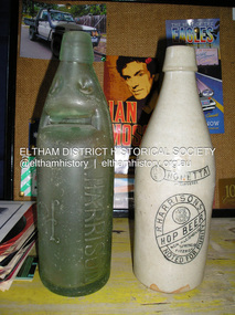
Photograph, Fay Bridge, Old bottles found at former Morrison property, Killeavey, Laughing Waters Road, Eltham, 2019
Lemonade, Non-alcoholic Hop Beer and milk bottlkes recovered from Killeavey give an insight into the types of drinks consumed by the Morrison family. Beatrice Wanliss Irvine was the daughter of former Victorian Premier Sir William Irvine. From age 13 she lived at “Killeavey” off Laughing Waters Road (later accessed from Reynolds Road). In 1923 she married James Morrison and the couple received Killeavey as a wedding gift. The property supported fruit and vegetable growing as well as an impressive botanical garden. But James died in 1936 after a period of ill health, leaving Beatrice to support their six children. The Killeavey house was built atop a cliff, 40 metres above the Yarra River. The garden was designed in 1910 by William Guilfoyle who was the second director of the Royal Botanical Gardens. The house was totally destroyed in the Black Friday bushfires in 1939, but was rebuilt. Beatrice continued to live at Killeavey and became well regarded as a botanist and naturalist. She died in 1989 and is buried in Eltham Cemetery with her husband and one of their sons. The (rebuilt) house was demolished by Parks Victoria. It contains significant garden remnants. The surrounding bushland is valued for its significant plant communities.fay bridge collection, beatrice wanliss morrison (nee irvine), eltham, james morrison, killeavey, laughing waters road, william irvine, bennett lemonade, bottles, milk bottle, o'neill bros north fitzroy, r. harrison, r. harrisons hop beer -
 Eltham District Historical Society Inc
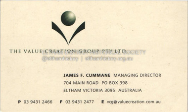
Document - Property Binder, 704 Main Road, Eltham
Business card, The Value Creating Group Pty Ltd, James F Cummane, managing director.main road, eltham, businesses -
 Glen Eira Historical Society
Document - Hart Family
Handwritten chronological list of properties owned by various members of the Hart family in the Caulfield area between 1858 and 1892. Includes house type number of rooms, addresses and annual council valuation rates.hart rodney, hart john, hart joseph, hart margaret, hart thomas, hart harriet, hart isaac, caulfield, house names, bambra road, houses, glen eira road, hawthorn road, sycamore street, land values, rates, callerne, blencairn, caulfield city council -
Glen Eira Historical Society
Letter - Hawthorn Road, 158, Caulfield
Carbon copy of letter dated 03/12/1963 for property at 158 Hawthorn Road Caulfield. Brief description of condition included with rent details and terms of sale comparison for this and 156 Hawthorn Road.hawthorn road, caulfield, turner florence, shops, shopping centres, rents and renting, land values -
Glen Eira Historical Society
Letter - Langslow Street, 2, Bentleigh East
Valuation of the property 2 Langslow Street, East Bentleigh by W.V. Scott for Mr. Harvey Mitchell on October 15, 1975. Also includes a page of unattributed handwritten notes of the calculations for the valuation of the particular property dated October 14, 1975.mitchell harvey, mitchell g.d., scott w.v., bentleigh east, land values, timber houses -
Glen Eira Historical Society
Letter - Kooyong Road, 415, Elsternwick
Two items about valuation of this property: 1/Typed letter dated 28/01/1977 from the Perpetual Executors and Trustees Association fo Australia Limited by Trust Officer RM Morrison to WV Scott of SP Simmond’s estate agents regarding the report and evaluation for the Sir Hugh Gerner Brian estate located at 415 Kooyong Road Elsternwick, included certificate of title. 2/Copy of typed letter by valuator WV Scott with details of the external and internal condition and valuation of the property with handwritten note,s dated 08/02/1977.kooyong road, elsternwick, brain hugh gerner sir, brain lady, land values, brick houses, bluestone -
Glen Eira Historical Society
Plan - Pascoe Avenue, 26, Bentleigh
Document detailing two valuations by National Trustees Co of the property at 26 Pascoe Ave, Bentleigh, the first valuation is dated 14/07/1954 and the second dated 19/07/1957. Included are handdrawn plans, handwritten notes and typed valuations listing values of architectural features, and correspondence from National Trustees Co. for both 1954 and 1957. The 1954 documents were clearly used in the 1957 valuation.pascoe ave, land subdivisions, land values, bentleigh, pergolas, architectural features, parish of moorabbin, plans, architectural styles, county of bourke, maps, brick houses, national trustees co, illustrations, dendy’s crown special survey -
Glen Eira Historical Society
Document - St. Georges Road, 68, Elsternwick
Two documents about the history and features of this property. A typed report about the ownership and occupancy from 1906 to 1978 of 68 St. Georges Road dated 21/07/1987 researched by Hailary Bullock and Rosalind Landells with handwritten working notes. Two evaluations, one for the house dated 05/05/1954, and one for the furnishings inside the house.st. georges road, george road, elsternwick, frederick sargood estate, sargood f., ripponlea, ring c., wrigley leslie j., belle vue, young stephen, locksley, cutts herbert, robertson david, robertson ada, edwards joseph, cording william, rybajzen jeko szaul, bullock hilary, landells rosalind, brighton historical society, architectural features, houses, land values, furnishings, brick houses, verandahs, cast iron work, edwards mrs -
Glen Eira Historical Society
Document - Shoobra Road, 20, Elsternwick
This file contains three articles about this property: Shoobra Road, 20, Elsternwick. 1/Advertising article from unknown source, dated April 2002, by Buxton. Gives brief interior feature details. Includes 3 coloured photographs. 2/Handwritten research on former occupiers of 20 Shoobra Road, taken from Sands and MacDougalls, by Claire Barton 19/06/2012. 3/Advertising feature article in Domain 11-12/11/2016. Article gives details of home renovations update since being bought in 2002. Article details across 3 columns the community values of Elsternwick area and surrounds, and includes a further three properties in the area, also up for auction. It includes a long column titled 'My Patch' from the current owner Amanda Ruben.elsternwick, stavrakis bill, architectural features, shoobra road, buxton, architectural features, real estate agents, bay windows, phelan john., lead lights, phelan f., glenhuntly road glen eira road, marleston park, ruben amanda, gardy mark, gardy cooper, gardy milla, edwardian style, 'miss ruben', restaurants, ripponlea, st. george's road, bertram street, orrong road -
Glen Eira Historical Society
Article - Shoobra Road, 75, Elsternwick
... architectural features and the value of updating property in already... VIC 3162 melbourne Two documents about this property ...Two documents about this property: Advertising article from Property Review Weekly dated 04/02/2005 and (2) 11/02/2005. Notes architectural features and the value of updating property in already good location; by estate agent Hocking Stuart.edwardian style, hocking stuart, leadlights, shoobra road, real estate agents, windows, elsternwick, newton todd, fireplaces, architectural features, rushford marshall, garage (private), glenhuntly road, caulfield -
Glen Eira Historical Society
Letter - Vadlure
Photocopy of a letter dated January 09, 1891 to J.A. Wallace from W.A. Zeal giving valuation of property Vadlure with a description of the house, outbuildings and gardens. Includes two copies of same site plan.vadlure, mansions, peterson john s, dandenong road, caulfield north, queen anne style, towers, art buildings, vegetable gardens, kooyong road, alma road, seal w.a., land values, engineers, surveyors -
Glen Eira Historical Society
Letter - Westfield, Corner Eskdale and Wyuna Roads, Caulfield North
Letter from George Stevens to Caulfield Historical Society dated 27/08/2001 regarding the owners of Westfield 1904 to 1952 plus a brief history of the property and the reason for the house name. Photocopy of two photographs plus handwritten notes on the value, owners and builder of Westfield.caulfield historical society, caulfield’s building heritage, eskdale road, kambrook road, wyuna road, stevens george, pescott david james, pescott james richard, pescott keith woodfull, heathcote norman, westfield, wyuna road, woodfull cecily, woodfull dorothy, heathcote norman mrs., heathcote norma, oakley norma, house names, solomon g. dr., dunbar margaret, leonard f., leonard s., timber houses, land values, heathcote dorothy -
Glen Eira Historical Society
Book - Hillcrest Estate Draft Heritage Guidelines July 2000
2 items about Hillcrest Estate and heritage: 1/A 20 page report giving draft heritage guidelines by the City of Glen Eira for properties within the Hillcrest Estate Heritage Area of Caulfield South, including Hillcrest Avenue numbers 1 and 3-12 and Marara Road numbers 27 and 28. The Heritage Area has been assessed as noteworthy as 'the first housing estate developed by the AV Jennings Construction Co., later known as Jennings Group Limited.' Developed during the Depression years of the early 1930s, it is considered an 'unusually intact example of an interwar garden estate' and is also considered noteworthy for its aesthetic values. The Report describes typical features for two house forms typical of the area: the single-storey villa with decorative porch and the single storey villa with decorative verandah. It gives guidelines on the types of changes which can be made to houses within the Heritage Area. Included are photographs of typical houses and design features, maps, and diagrams showing acceptable zones for additions, amongst other Sections (eg. Key design checklist). 2/A three page photocopy taken from Andrew Ward's Heritage Study for The Hillcrest Estate Historic Area.hillcrest estate, glen eira heritage management plan, glen eira planning scheme, glen eira city council, hillcrest estate heritage area, hillcrest avenue, merri street, marara road, eumerella street, av jennings construction co, jennings group limited, caulfield south, jennings albert, brick houses, architectural styles, architectural features, housing estates, garden estate, heritage studies, glen eira city council, city of glen eira, draft heritage guidelines july 2000, glen huntly, vines william, gurney edward, eumeralla street, 'karkill', house names, cropmpton court, booran road, estate agents -
Glen Eira Historical Society
Plan - Jasper Road, 236-246, McKinnon
Three items relating to the valuation of this property: 1/A typed copy of a three page valuation of 236-246 Jasper Road, McKinnon, by valuator W V Scott for Atlantic Union Oil Co Pty Ltd, dated 11/08/1961. Accompanying this are a hand-drawn plan of the property and handwritten working notes for the valuation. 2/One additional page of correspondence from W V Scott to Atlantic Union Oil, dated 11/08/1961, informing them that the occupier of the property, L A Atkinson’s Garage and Panel Beating Works, was aware of the valuation taking place. 3/Field Purchase Order for the valuation of the property from Atlantic Union Oil Company Pty. Limited dated 19/07/1961.jasper road, mckinnon road, mckinnon, atkinson l.a, webb d mr, l.a atkinson’s garage and panel beating works, moorabbin council, atkinson mr, atlantic oil co pty ltd, morris g h, scott w v, motor vehicle repair shops, garages, petrol stations, factories, land use, land values, anderson's garage & panel beating works