Showing 109 items
matching s webster
-
 Eltham District Historical Society Inc
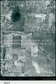
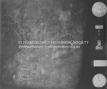
Photograph - Aerial Photograph, Landata, Eltham, Vic, Apr. 1972
Centred on present day Parsons Road, Eltham bounded by Allendale Road to north, Frank Street to south, Research Shops and Raglan Road to east and Zig Zag Road to west. Historic Aerial Imagery Source: Landata.vic.gov.au Aerial Photo Details: Project No :985 Project : MELBOURNE 1972 Run : 26 Frame : 192 Date : 04/1972 Film Type : B/W Camera : RC10 Flying Height : 5700 Scale : 9600 Film Number : 2636 GDA2020 : 37°42'00"S, 145°09'59"E MGA2020 : 338360, 5825897 (55) Melways : 22 D1 (ed. 42)aerial photo, neil webster collection, 1972-04, allendale road, eltham, zig zag road, frank street, melway 22d1, parsons road, raglan road, research (vic.), research shops, eltham barrel -
 Eltham District Historical Society Inc
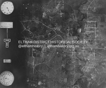
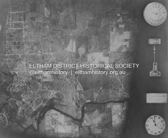
Photograph - Aerial Photograph, Landata, Research, Vic, Apr. 1972
Centred on present day Maroong Drive, Research bounded by Allendale Road to north, Thompson Crescent to south, Eltham College to east and Parsons Road to west. Historic Aerial Imagery Source: Landata.vic.gov.au Aerial Photo Details: Project No :985 Project : MELBOURNE 1972 Run : 26 Frame : 193 Date : 04/1972 Film Type : B/W Camera : RC10 Flying Height : 5700 Scale : 9600 Film Number : 2636 GDA2020 : 37°42'04"S, 145°10'33"E MGA2020 : 339187, 5825794 (55) Melways : 22 F1 (ed. 42)aerial photo, neil webster collection, 1972-04, allendale road, eltham, eltham barrel, eltham college, maroong drive, melway 22f1, parsons road, research (vic.), thompson crescent -
 Eltham District Historical Society Inc
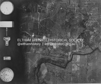
Photograph - Aerial Photograph, Landata, Research, Vic, Apr. 1972
Centred on present day Main Road, Research near Maroondah Aqueduct and Eltham College bounded by Allendale Road to north, Research-Warrandyte Road to south, Swipers Gully Training Restaurant to east and Reynolds Road to west. Historic Aerial Imagery Source: Landata.vic.gov.au Aerial Photo Details: Project No :985 Project : MELBOURNE 1972 Run : 26 Frame : 194 Date : 04/1972 Film Type : B/W Camera : RC10 Flying Height : 5700 Scale : 9600 Film Number : 2636 GDA2020 : 37°42'07"S, 145°11'07"E MGA2020 : 340015, 5825692 (55) Melways : 22 H1 (ed. 42)aerial photo, neil webster collection, 1972-04, allendale road, eltham college, main road, maroondah aqueduct, melway 22h1, research (vic.), research-warrandyte road, reynolds road, swiper's gully -
 Eltham District Historical Society Inc
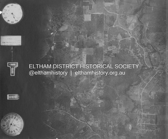
Photograph - Aerial Photograph, Landata, Eltham, Vic, Apr. 1972
Centred on present day Woodridge Estate, Eltham bounded by Park Road to north, Mount Pleasant Road to south, Stokes Orchard Estate to east and Eltham Railway Station to west. Historic Aerial Imagery Source: Landata.vic.gov.au Aerial Photo Details: Project No :985 Project : MELBOURNE 1972 Run : 27 Frame : 46 Date : 04/1972 Film Type : B/W Camera : RC10 Flying Height : 5700 Scale : 9600 Film Number : 2636 GDA2020 : 37°42'49"S, 145°09'46"E MGA2020 : 338053, 5824365 (55) Melways : 22 C5 (ed. 42)aerial photo, neil webster collection, 1972-04, eltham, eltham railway station, melway 22c5, mount pleasant road, park road, stokes orchard estate, woodridge estate -
 Eltham District Historical Society Inc
Photograph - Aerial Photograph, Landata, Eltham, Vic, Apr. 1972
Centred on present day Main Road at Pryor Street, Eltham bounded by Park West Road to north, Napoleon Street to south, Woodridge Estate to east and Ryans Road to west. Historic Aerial Imagery Source: Landata.vic.gov.au Aerial Photo Details: Project No :985 Project : MELBOURNE 1972 Run : 27 Frame : 47 Date : 04/1972 Film Type : B/W Camera : RC10 Flying Height : 5700 Scale : 9600 Film Number : 2636 GDA2020 : 37°42'45"S, 145°09'12"E MGA2020 : 337223, 5824470 (55) Melways : 22 A4 (ed. 42)aerial photo, neil webster collection, 1972-04, eltham, eltham railway station, woodridge estate, eltham shops, main road, melway 22a4, napoleon street, park west road, pryor street, ryans road -
 Eltham District Historical Society Inc
Photograph - Aerial Photograph, Landata, Eltham, Vic, Apr. 1972
Centred on present day Ryans Road at Sandra Avenue, Eltham bounded by Progress Road to north, Brougham Street to south, Bible Street to east and Outlook Crescent to west. Historic Aerial Imagery Source: Landata.vic.gov.au Aerial Photo Details: Project No :985 Project : MELBOURNE 1972 Run : 27 Frame : 48 Date : 04/1972 Film Type : B/W Camera : RC10 Flying Height : 5700 Scale : 9600 Film Number : 2636 GDA2020 : 37°42'41"S, 145°08'38"E MGA2020 : 336392, 5824574 (55) Melways : 21 H4 (ed. 42)aerial photo, neil webster collection, 1972-04, eltham, bible street, brougham steet, melway 21h4, outlook crescent, progress road, ryans road, sandra avenue, montmorency -
 Eltham District Historical Society Inc
Photograph - Aerial Photograph, Landata, Montmorency, Vic, Apr. 1972
Centred on present day Olympic Avenue at Grand Boulevard, Montmorency bounded by Meruka Drive to north, Main Road to south, Main Road to east and Alban Street to west. Historic Aerial Imagery Source: Landata.vic.gov.au Aerial Photo Details: Project No :985 Project : MELBOURNE 1972 Run : 28 Frame : 206 Date : 04/1972 Film Type : B/W Camera : RC10 Flying Height : 5700 Scale : 9600 Film Number : 2635 GDA2020 : 37°43'21"S, 145°07'46"E MGA2020 : 335154, 5823329 (55) Melways : 21 E7 (ed. 42)aerial photo, neil webster collection, 1972-04, eltham, alban street, grand boulevard, lower plenty, main road, melway 21e7, meruka drive, montmorency, olympic avenue -
 Eltham District Historical Society Inc
Photograph - Aerial Photograph, Landata, Eltham, Vic, Apr. 1972
Centred on present day Diamond Creek Trail at the Eltham Leisure Centre bounded by Central Park to north, Main Road at Falkiner Street to south, MacMahon Ball Paddock to east and Grand Boulevard at Buena Vista Drive to west. Historic Aerial Imagery Source: Landata.vic.gov.au Aerial Photo Details: Project No :985 Project : MELBOURNE 1972 Run : 28 Frame : 207 Date : 04/1972 Film Type : B/W Camera : RC10 Flying Height : 5700 Scale : 9600 Film Number : 2635 GDA2020 : 37°43'25"S, 145°08'20"E MGA2020 : 335985, 5823223 (55) Melways : 21 G7 (ed. 42)aerial photo, neil webster collection, 1972-04, eltham, buena vista drive, central park, diamond creek trail, eltham leisure centre, falkiner street, grand boulevard, macmahon ball paddock, main road, melway 21g7 -
 Eltham District Historical Society Inc
Photograph - Aerial Photograph, Landata, Eltham, Vic, Apr. 1972
Centred on present day Dalton Street at Mount Pleasant Road, Eltham bounded by Arthur Street to north, Yarra River and Kent Hughes Road to south, Eucalyptus Road to east and Susan Street to west. Historic Aerial Imagery Source: Landata.vic.gov.au Aerial Photo Details: Project No :985 Project : MELBOURNE 1972 Run : 28 Frame : 208 Date : 04/1972 Film Type : B/W Camera : RC10 Flying Height : 5700 Scale : 9600 Film Number : 2635 GDA2020 : 37°43'29"S, 145°08'54"E MGA2020 : 336816, 5823118 (55) Melways : 21 J8 (ed. 42)aerial photo, neil webster collection, 1972-04, eltham, arthur street, dalton street, eucalyptus road, kent hughes road, melway 21j8, mount pleasant road, susan street, yarra river -
 Eltham District Historical Society Inc
Photograph - Aerial Photograph, Landata, Eltham, Vic, Apr. 1972
Centred on present day Mays Road at Stringybark Road, Eltham bounded by Nyora Road to north, Yarra River to south, Reynolds Road to east and Bible Street to west. Historic Aerial Imagery Source: Landata.vic.gov.au Aerial Photo Details: Project No :985 Project : MELBOURNE 1972 Run : 28 Frame : 209 Date : 04/1972 Film Type : B/W Camera : RC10 Flying Height : 5700 Scale : 9600 Film Number : 2635 GDA2020 : 37°43'33"S, 145°09'28"E MGA2020 : 337647, 5823013 (55) Melways : 22 B8 (ed. 42)aerial photo, neil webster collection, 1972-04, eltham, bible street, mays road, melway 22b8, nyora road, reynolds road, stringybark road, yarra river -
 Eltham District Historical Society Inc
Photograph - Aerial Photograph, Landata, Eltham, Main Road; Henry St to Bellevue Rd, Dec. 1945
Eltham, Main Road; Henry St to Bellevue Rd, and east along Luck St to present day Eltham East School Historic Aerial Imagery Source: Landata.vic.gov.au Aerial Photo Details: Project No :5 Project : MELBOURNE AND METROPOLITAN AREA PROJECT Run : 36 Frame : 60549 Date : 12/1945 Film Type : B/W Camera : EAG4 Flying Height : 10200 Scale : 6000 Film Number : 228 GDA2020 : 37°42'45"S, 145°08'59"E MGA2020 : 336903, 5824465 (55) Melways : 21 K4 (ed. 42)aerial photo, arthur street, bellevue road, bible street, diamond street, dudley street, elsa court, eltham, eltham east primary school, gahan house, henry street, livingstone road, luck street, main road, pryor street, neil webster collection -
 Eltham District Historical Society Inc
Photograph - Aerial Photograph, Landata, Eltham, Luck St; Bible St to Beard St, Dec. 1945
Centred on present day Eltham East Primary School, east of Main Rd along Luck St to Beard St Historic Aerial Imagery Source: Landata.vic.gov.au Aerial Photo Details: Project No :5 Project : MELBOURNE AND METROPOLITAN AREA PROJECT Run : 36 Frame : 60548 Date : 12/1945 Film Type : B/W Camera : EAG4 Flying Height : 10200 Scale : 6000 Film Number : 195 GDA2020 : 37°42'46"S, 145°09'18"E MGA2020 : 337371, 5824456 (55) Melways : 22 A4 (ed. 42)aerial photo, eltham, arthur street, beard street, bible street, eltham east primary school, frank street, henry street, luck street, stanley avenue, wycliffe crescent, neil webster collection -
 Eltham District Historical Society Inc
Photograph - Aerial Photograph, Landata, Eltham, Main Rd; Railway Rd to Zig Zag Rd, Dec. 1945
Centred on present day Edendale Farm from Glen Park rd to Zig Zag Rd Historic Aerial Imagery Source: Landata.vic.gov.au Aerial Photo Details: Project No :5 Project : MELBOURNE AND METROPOLITAN AREA PROJECT Run : 37 Frame : 60549 Date : 12/1945 Film Type : B/W Camera : EAG4 Flying Height : 10200 Scale : 6000 Film Number : 196 GDA2020 : 37°42'12"S, 145°09'09"E MGA2020 : 337141, 5825486 (55) Melways : 21 K2 (ed. 42)aerial photo, eltham, edendale farm, eltham - yarra glen road, eltham-hurstbridge railway line, gastons homestead, gastons road, glen park road, main road, park road, railway road, wattletree road, zig zag road, neil webster collection -
 Eltham District Historical Society Inc
Photograph - Aerial Photograph, Landata, Eltham, Main Road; Mt Pleasant Rd to Railway Rd, Dec. 1945
Centred on Main Rd and Henry St, Eltham bounded by Railway Road to north, Mount Pleasant Road at Main Road to south, top of the hill in Arthur Street to east and Karingal Drive at Sherbourne Road to west. Historic Aerial Imagery Source: Landata.vic.gov.au Aerial Photo Details: Project No :65 Project : MELBOURNE AND METROPOLITAN PROJECT NO. 2 Run : 8 Frame : 70 Date : 01/1951 Film Type : B/W Camera : EAG9 Flying Height : 12200 Scale : 12000 Film Number : 1419 GDA2020 : 37°43'06"S, 145°08'45"E MGA2020 : 336589, 5823811 (55) Melways : 21 J6 (ed. 42)aerial photo, eltham, main road, henry street, arthur street, bolton street, eltham-yarra glen road, neil webster collection, 1951-01, dave lyon house, ernie andrew house, karingal road, melway 21j6, mount pleasant road, railway road -
 Eltham District Historical Society Inc
Photograph - Aerial Photograph, Landata, Eltham and Lower Plenty, Nov. 1931
Centred over present-day Rosehill Road and View Road, Lower Plenty Historic Aerial Imagery Source: Landata.vic.gov.au Aerial Photo Details: Project No :1931 Project : MALDON PRISON Run : 19 Frame : 3129 Date : 11/1931 Film Type : B/W Camera : F8 Flying Height : 11000 Scale : 18860 Film Number : 60 GDA2020 : 37°44'16"S, 145°07'40"E MGA2020 : 335039, 5821622 (55) Melways : 21 E11 (ed. 42)aerial photo, eltham, lower plenty, neil webster collection, rosehill road, view road -
 Eltham District Historical Society Inc
Photograph - Aerial Photograph, Landata, Eltham and Montmorency, Nov. 1931
Centred over present-day Belmont Reserve, Montmorency Historic Aerial Imagery Source: Landata.vic.gov.au Aerial Photo Details: Project No :1931 Project : MALDON PRISON Run : 19 Frame : 3130 Date : 11/1931 Film Type : B/W Camera : F8 Flying Height : 11000 Scale : 18860 Film Number : 60 GDA2020 : 37°43'13"S, 145°07'54"E MGA2020 : 335330, 5823576 (55) Melways : 21 F6 (ed. 42)aerial photo, eltham, neil webster collection, belmont reserve, montmorency, rattray road -
 Eltham District Historical Society Inc
Photograph - Aerial Photograph, Landata, Eltham and Eltham North, Nov. 1931
Centred over present-day Opal Court and Manning Road, Eltham North Historic Aerial Imagery Source: Landata.vic.gov.au Aerial Photo Details: Project No :1931 Project : MALDON PRISON Run : 19 Frame : 3131 Date : 11/1931 Film Type : B/W Camera : F8 Flying Height : 11000 Scale : 18860 Film Number : 60 GDA2020 : 37°42'10"S, 145°08'07"E MGA2020 : 335621, 5825531 (55) Melways : 21 G2 (ed. 42)aerial photo, eltham, neil webster collection, eltham north, manning road, opal court -
 Eltham District Historical Society Inc
Photograph - Aerial Photograph, Landata, Eltham and Eltham East, Nov. 1931
Centred over present-day Beard Street bewteen Park Road and Main Road, Eltham East Historic Aerial Imagery Source: Landata.vic.gov.au Aerial Photo Details: Project No :1931 Project : MALDON PRISON Run : 20 Frame : 3135 Date : 11/1931 Film Type : B/W Camera : F8 Flying Height : 11000 Scale : 18860 Film Number : 60 GDA2020 : 37°42'16"S, 145°09'41"E MGA2020 : 337912, 5825386 (55) Melways : 22 B2 (ed. 42)aerial photo, eltham, neil webster collection, beard street, eltham east, main road, park road -
 Eltham District Historical Society Inc
Photograph - Aerial Photograph, Landata, Eltham, Nov. 1931
Centred over present-day Laleham Court between Arthur Street and Hartland Way, Eltham Historic Aerial Imagery Source: Landata.vic.gov.au Aerial Photo Details: Project No :1931 Project : MALDON PRISON Run : 20 Frame : 3136 Date : 11/1931 Film Type : B/W Camera : F8 Flying Height : 11000 Scale : 18860 Film Number : 60 GDA2020 : 37°42'56"S, 145°09'33"E MGA2020 : 337759, 5824139 (55) Melways : 22 B5 (ed. 42) aerial photo, eltham, neil webster collection, arthur street, hartland way, laleham court -
 Eltham District Historical Society Inc
Photograph - Aerial Photograph, Landata, Eltham, Nov. 1931
Centred over Mount Pleasant Road and Kent Hughes Road, Eltham Historic Aerial Imagery Source: Landata.vic.gov.au Aerial Photo Details: Project No :1931 Project : MALDON PRISON Run : 20 Frame : 3137 Date : 11/1931 Film Type : B/W Camera : F8 Flying Height : 11000 Scale : 18860 Film Number : 60 GDA2020 : 37°43'37"S, 145°09'26"E MGA2020 : 337606, 5822892 (55) Melways : 22 A8 (ed. 42) aerial photo, eltham, neil webster collection, kent hughes road, mount pleasant road -
 Eltham District Historical Society Inc
Document - Map, Doug Orford, Main Road, Eltham (c..1930s-1970s), c.2010
Map of Main Road with listings of all properties (shops/homes) from Mount Pleasant Road through to Pryor Street from the 1930s on to about the 1970sandrew store, andrews newsagency, arthur street, babe taylor house, bakery, barbers blue gum store, blue gum, boarding house, bootmakers cottage, bottle shop, bradford butcher shop, bradford house, bradley house, brdbury house, bridge street, brooker, brougham steet, brown blacksmith, browne's grocer, bryant, burgoyne post office, burgoyne's shop, capewell butcher shop, catholic church, catholic school, chandlers lolly shop, cheddar black, chiropractor, cockcroft, commercial bank of australia, copelands chemist, copelands dairy, d. hall house, dave lyon house, david lyon house, dr cordner, dr loosli, dr r. bradbury, dudley street, eltham, eltham bakehouse, eltham courthouse, eltham fire brigade, eltham living and learning centre, eltham pre-school, eltham railway station, eltham shire office, eltham station masters house, eltham war memorial, f. collis store, feed store, fountain hotel, franklin street, gadd's blacksmith, gahan house, garnet burges, george bird grocer, gollings, grant house, harry hawker, headmaster's resience, henry street, hepburn house, hills house, isherwood house and shop, jack ryan, jack shallard, james house, jarrold cottage, jim ryan, john lyon house, kilpatrick, le brocq, leather and harness, len parsons, lock-up, lyon bros garage, main road, map, mathews house, mclean's produce store, mechanics institute, methodist church, methodist hall, milkbar, mills bootmaker, miss george, monteith house, mount pleasant road, mrs bradbury, mrs davis house, mrs jewell, mrs mbremner store, mrs morris shop, napoleon street, obelisk, panther place, peter gahan, pitt street, plumber, police residence, poultry and market garden, pryor street, railway house, rains newsagency, real estate agent, reeves general store, s. bradbury, shillinglaw cottage, staffs general store, stones mixed shop, tennis court, timber yard, w. walker, w.b. andrew corn store, warren's general store, water trough, watsons hotel, websters house, whitecloud cottage, whites general store, williams bootmaker, wingrove cottage, wingrove park, woodyard, york street, franco and co -
 Federation University Historical Collection
Letter, Inward Correspondence to the Ballarat School of Mines, 1910, 08/1910
Inward Correspondence to the Ballarat School of Mines, November 1910letterhead, education department, telegram, yarraville chlorination and ore reduction works, a. anderson, h.b. silberberg & co, a.h. walsh, j.m. edgar, charles w. frost, gordon technical college, g. king, jennings deep lead tingha tin mining company, ballarat city board of advice, metallurgical laboratory, s. radcliff, f.w. hall, ararat, gordon technical school, d.c. newham, staffordshire reef, john wilesmith, sandstone western australia, j. worthington, elaine, j. loughman, gold buyers act, h.h. smith, incorporated institute of accountants, james stapp, electric supply companyof victoria, h.j. spencer, tasmanis mines department, david melvin, caulter f. ingpen, hobson's gold mining company, canadian finance and securities, scott hotel steiglitz, g. straight, jubilee mine italians, elsie alcock, dressmaking, w.a. t. davies, legislative assembly, state forests department, myles b. webster, photography, albury, commercial banking company sydney -
 Flagstaff Hill Maritime Museum and Village
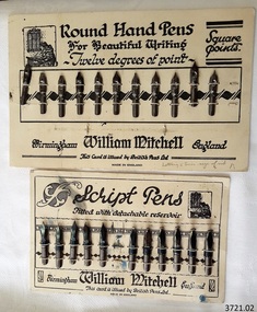
Pen Nibs, 1920's
The two cards of nibs are retail display cards of the dip pen nibs that William Mitchell Calligraphy produced, dating back to around the 1920’s, which was the time of the Great Exhibition in the UK. At that time dip pens with steel nibs were the main writing instruments. British Pens Ltd. had recently formed as a company and its subsidiaries included the the company William Mitchell, which is why British Pens Ltd. is named on the cards as well. One card (1) has the Round Hand nib, which is widely used today for calligraphy scripts. The other card (2) has the Script nib that has round upturned points for monocline or unshaded lettering that is also used for calligraphy. The nibs also have a detachable reservoir. The pen nibs are shaped to fit into a slot in the base of a wooden or Bakelite pen holder. The hole at the front of the nib is for collecting ink from a well, which is then stored in a reservoir at the back of the nib. The nibsare stamped with their nib size and Pedigree (what type of nib it is) and maker’s details. William Mitchell Calligraphy still makes these nibs today with a slightly difference finish. (ref: Sales and Marketing Director of William Mitchell Calligraphy in 2016). HISTORY of the Ink Pen Quills and ink were common writing tools until the early 19th century when the pen trade began mass producing steel nibs and pens. The steel nibs each have a hole in the middle that acts like a well for the ink. When the nib is dipped into the ink well the writer needs to ensure that it is dipped to only just past that well. India Ink was one of the most popular inks used with the nib pens, notable for its satin-like smooth flow. This ink is composed of a particularly fine carbon mixed with water; it can also be obtained as a dry stick that is then crushed and mixed with water as required. The Jewellery Quarter of Birmingham had the largest concentration of independent jewellers in Europe. Birmingham became the centre of the world’s pen trade for many years -, during the 1800’s over 100 factories, employing 1000s of skilled workers, manufactured the ‘Birmingham Pen’. ABOUT WILLIAM MITCHELL CALLIGRAPHY LTD.* (*The following text is quoted from the William Mitchell Calligraphy website) British based William Mitchell Calligraphy has been designing and manufacturing exceptional pens for almost 200 years. The William Mitchell heritage in making pen nibs began whilst working with his brother John Mitchell in the early 1820s. William Mitchell established his own business in 1825 to become one of the leading nib manufacturers and famous for lettering pens. Almost 100 years later William Mitchell merged with Hinks, Wells & Co, another pen manufacturer, to form British Pens, employing around 1000 people in the Bearwood Road area of Birmingham. During the early 1960s British Pens acquired the pen business of other pen manufacturers Perry & Co and John Mitchell, once again reuniting the two brothers. Joseph Gillott, who were famous for their artist drawing and mapping nibs, amalgamated with British pens in 1969. William Mitchell and Joseph Gillott established in Birmingham during the early part of the nineteenth century and [their products] are still proudly made here. British Pens were subsequently purchased by its current owner Byron Head, the owner of William Mitchell (Sinkers) in 1982, and was subsequently renamed William Mitchell (calligraphy) Ltd. Established in 1827 Joseph Gillott was one of the pioneers of mass steel pen nib manufacturing. The company was particularly strong in the American market, prompting Elihu Burrit, the American consul, to write “In ten thousand school houses across the American continent between two oceans, a million children are as familiarly acquainted with Joseph Gillott as with Noah Webster” (The compiler of the famous American dictionary). The company consequently received visits from many notable Americans, including president Ulysses S Grant. The early 19th century invention and mass production of pen nibs such these in our collection had a large impact on education and literacy because the nibs could be produced in great numbers and affordable prices.Pen nibs; 2 cards of steel dip pen nibs from the 1920’s. The steel nibs are attached to cards by 2 rows of entwined cotton cord. Reverse sides of cards have some hand written marks. Manufacturer; William Mitchell, Birmingham, England. Card issued by British Pens Ltd. Nibs have shaped ends, a hole in the centre with a well on the underside, and the tops are shaped approximately quarter circle. Inscriptions are pressed into each nib. The script pens have detachable reservoirs made of a metal different to the nib. (Card 1) Round Hand Pens, 11 nibs remain from card of 12. Printed on card “Round Hand Pens for Beautiful Writing, Twelve degrees of point, Square points. William Mitchell, Birmingham, England. This card is issued by British Pens Ltd. MADE IN ENGLAND” Also printed on top left of card is a pen drawing of a person writing at a desk, background of decorative 3-paned window in brick wall. (Card 2) Script Pens; 11 nibs remain from card of 12. “Script pens fitted with detachable reservoir. William Mitchell, Birmingham, England. This card is issued by British Pens Ltd. MADE IN ENGLAND” Also printed on top right of card is a pen drawing of a person writing at a desk, background of decorative 3-paned window in brick wall. On Card 1, - each nib is stamped with its size, and “Wm MITCHELLS / PEDIGREE / ROUND HAND / ENGLAND” - hand written on front bottom of card in ball point pen “Lettering 5 times size of nib” - hand drawn on back of card in red and blue ball point pen are scribbled lines On Card 2 - each nib is stamped with its size, and “WILLIAM / MITCHELLS / SCRIPT PEN / ENGLAND” - a black circle corresponding to the nib is printed on the card above each nib. - hand written on back of card in black felt tip pen are numerals - hand drawn on back, 4 parallel lines in red ball point pen with the numbers “10” between 2 of the lines flagstaff hill, warrnambool, shipwrecked coast, flagstaff hill maritime museum, maritime museum, shipwreck coast, great ocean road, william mitchell calligraphy ltd, british pens ltd., pen nib, writing implement, dip pen, round hand nib, script nib, birmingham manufacturer, communication in writing, mass produced pen nibs -
Phillip Island and District Historical Society Inc.
Book, Webster, M. S. (Mona Stuart), history of the Mont Albert shopping centre 1887-1985, 1986
... Webster, M. S. (Mona Stuart)... Webster, M. S. (Mona Stuart) Box Hill City Historical Society ...mont albert shopping centre, history, victoria -
 Federation University Historical Collection
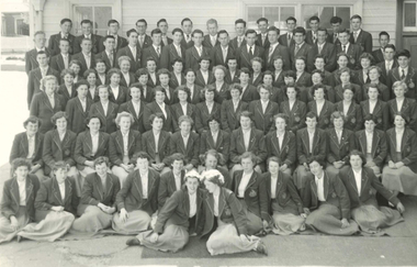
Photograph, Ballarat Teachers' College, 1953
The Ballarat Teachers' College is a predecessor institution of Federation University Australia. This photograph is reproduced in the 1953 edition of 'Extra Muros', the annual magazine of the Ballarat Teachers' College. Group of first year student of the Ballarat Teachers' College in the grounds of Dana Street Primary School, where their College was located. Back Row: D. Henderson, R. Veal, J. Brasier, D. Nunn, Ken Johnson, G. Osborne, P. Brumby, Graeme Anson, R. Williams, R. Romanes. M. Brennan, M. Jeffey, A. Brown. 2nd Row: John Dixon, K. Ryan, L. Coad, P. Callahan, John Gilbert, H. McLachlan, S. Morgan, J. Campbell, G. Keller, Ian Webster, R. Bryant, J. Hullick, K. Rogers, K. Greenway, B. Thomas. 3rd Row: J. Cameron, M. Simpson, M. McNeil, H. Cornish, C. Brown, A. Mead, Margaret Bywaters, D. Wallish, T. Everett, B. Wallace, A. Flavell, Gwen Brereton, M. Gebbie, V. Rodber, R. Dudley. 4th Row: M. Harvey, M. Beeson, Pat Wilkinson, M. Stevenson, L. Place, M. Barker, J. Bray, Gl. Evans, Gw Evans, D. Vary, Janifer Rogerson, P. Grubb, J. van Leeuwan, D. Bautovich. 5th Row: J. Filcock, J. Watts, B. Peterson, J. McArdle, Helen Sadler, J. Plush, Bette Harvey, R. Rule, E. Leach, D. Carroll, A. unn, B. Laurissen, V. James, J. Higgins. 6th Row: J. Turton, T. Nicoll, J. Wiltshire, A. Bolster, L. Howard, M. Corbett, M. Mill, M. McKay, I. Paul, J. Phelan, P. Ross, J. Piper, W. Jones. Front Row: N. McPherson, G. Lougheed, B. Tonks, I. Work, L. Hall, R. Mason, E. Menadue, E. Mercovich, J. McMillan, P. Fogarty. ballarat teachers' college, d. henderson, r. veal, j. brasier, d. nunn, k. johnston, g. osborne, p. brumby, g. anson, r. williams, m. jeffey, a. brown., k. ryan, l. coad, p. callahan, j. gilbert, h. mclachlan, s. morgan, j. campbell, g. keller, i. webster, r. bryant, j. hullick, k. rogers, k. greenway, b. thomas., m. simpson, m. mcneil, h. cornish, c. brown, a. mead, m. bywaters, d. wallish, t. everett, b. wallace, a. flavell, g. brereton, m. gebbie, v. rodber, r. dudley., m. beeson, p. wilkinson, m. stevenson, l. place, m. barker, j. bray, gl. evans, gw evans, d. vary, janifer rogerson, p. grubb, j. van leeuwan, d. bautovich., 5th row: j. filcock, j. watts, b. peterson, j. mcardle, h. sadler, j. plush, b. harey, r. rule, e. leach, d. carroll, a. unn, b. laurissen, v. james, j. higgins., t. nicoll, j. wiltshire, a. bolster, l. howard, m. corbett, m. mill, m. mckay, i. paul, j. phelan, p. ross, j. piper, w. jones., g. lougheed, b. tonks, i. work, l. hall, r. mason, e. menadue, e. mercovich, j. mcmillan, p. fogarty., r. romanes, m. brennan, j. dixon, j. cameron, m. harvey, j. turton, n. mcpherson, ken johnson, graeme anson, john gilbert, ian webster, margaret bywaters, gwen brereton, 4th row: m. harvey, pat wilkinson, helen sadler, bette harvey, a. nunn, john dixon -
 Glen Eira Historical Society
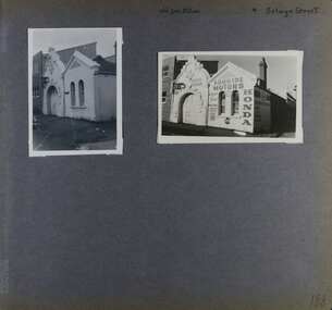
Album - Album page, Old Fire Station, 4 Selwyn Street, Circa 1972
This album was created in approximately 1972 as part of a project by the Caulfield Historical Society to assist in identifying buildings worthy of preservation. The album is related to a Survey the Caulfield Historical Society developed in collaboration with the National Trust of Australia (Victoria) and Caulfield City Council to identify historic buildings within the City of Caulfield that warranted the protection of a National Trust Classification. Principal photographer thought to be Trevor Hart, member of Caulfield Historical Society. Most photographs were taken between 1966-1972 with a small number of photographs being older and from unknown sources. All photographs are black and white except where stated, with 386 photographs over 198 pages. From Victorian Heritage Database citation for H2376 Former Elsternwick Fire Station, 2-4 Selwyn Street Elsternwick - Victorian Heritage Register https://vhd.heritagecouncil.vic.gov.au/places/2645 (as at 21/11/2021) The Former Elsternwick Fire Station was built and commenced operation in 1896. It was one of 32 new fire stations built between 1892 and 1896 by the newly formed Melbourne Metropolitan Fire Brigade ('MFB') to form a comprehensive fire-fighting network across Melbourne. The MFB was established in 1891 as Victoria's government-run fire-fighting service in Melbourne and its growing suburbs. By 1918 motorised fire engine appliances had replaced horse-drawn fire vehicles across the metropolitan area, and the consequently larger areas that fire stations could protect meant the 1896 Elsternwick Fire Station was one of many which was becoming obsolete. The MFB continued to use the Elsternwick Fire Station up until the Station's closure in 1926. From 1927 the former Fire Station was leased by neighbouring timber merchants JJ Webster Pty Ltd who subsequently purchased the property from the MFB in 1934. From 1954 the 'Esquire Motors' car repair business traded at the site, and changes to the former Fire Station building including the complete enclosure of its yard by corrugated steel walls and roofing appear to have been completed in the mid-1950s. In 1990 the Australian Broadcasting Corporation ('ABC') purchased the former Fire Station together with five other adjoining land parcels in Selwyn Street. From that time until 2017 the former Elsternwick Fire Station has been used by the ABC as office and storage space in its Selwyn Street television studio complex.From Victorian Heritage Database citation for H2376 Former Elsternwick Fire Station, 2-4 Selwyn Street Elsternwick - Victorian Heritage Register https://vhd.heritagecouncil.vic.gov.au/places/2645 (as at 21/11/2021) The Former Elsternwick Fire Station is historically significant as one of the 10 remaining fire stations of the original 32 built for the newly established Melbourne Metropolitan Fire Brigade ('MFB') during the four-year period 1892 to 1896. These fire stations were constructed following the establishment in 1891 of the MFB, Victoria's government-run fire-fighting service for metropolitan Melbourne and its growing suburban population. These new stations formed a crucial part of the MFB's fire-fighting network across Melbourne. The Former Elsternwick Fire Station clearly demonstrates the historical development of fire-fighting services in Melbourne, especially the expansion of the newly-formed MFB throughout Melbourne's suburbs during the 1890s. [Criterion A] The Former Elsternwick Fire Station is architecturally significant as a fine example of a late nineteenth century fire station. Constructed shortly after the establishment of the MFB, it displays characteristics of its class of place that remain mostly unchanged from the former Station's historically important period of development and use. A particularly strong element of the Former Elsternwick Fire Station is the large and strikingly-detailed stone horseshoe arch, designed for horse-drawn fire-fighting vehicles, at the street entrance to its fire-engine room. [Criterion D]Page 188 of Photograph Album with two photographs of the old Elsternwick Fire Station.Handwritten: old fire station 4 Selwyn Street [top right] / 188 [bottom right]trevor hart, rendered, 1890's, melbourne metropolitan fire brigade, mfb, fire-fighting, jj webster, timber merchants, esquire motors, car repair, australian broadcasting corporation, abc, selwyn street, brick and stone, asymmetrical facade, anglo-dutch gable, rusticated and smooth-faced limestone, elsternwick fire station, elsternwick, fire station, jj webster pty ltd, motor vehicle repair shops, stone horseshoe arch entrance -
Glen Eira Historical Society
Document - ROTARY CLUB OF CAULFIELD
This file contains 13 official documents pertaining to the Rotary Club of Caulfield: 1/A typewritten copy of the constitution of the Rotary Club of Caulfield (undated). Said document is essentially an instruction manual detailing how the Club is to be administered and the duties of officials. 2/A page (unclear if intended for use as a poster or letter) announcing a Business Persons Breakfast to be held at St. Anthony’s Parish Hall on 19/11/1986, wherein Jeff Kennett, M.L.A., Leader of the Opposition of the Parliament of Victoria, will deliver a speech titled ‘Responsibility Before Rights’. 3/A booklet announcing the 25th anniversary celebration of the Rotary Club of Caulfield, to be held at Tudor Court on 24/02/1987. Contains the menu, national anthem, programme, and two lists – one of the founding members of the Club and one of the extant members of the Club. 4/Two copies of a booklet announcing a dinner, to be held at Tudor Court on 10/11/1987, wherein charter will be presented to the Rotary Club of Caulfield-Rosstown by District Governor Ian Knight. Contains a list of extant staff, the menu, the programme, a description of the history of the ‘Wembley Wheel of Friendship’, a list of charter members, and an account of the etymology of the name ‘Rosstown’. 5/Two copies of a page featuring four items of relevance to the Rotary Club of Caulfield. The first is an article (titled ‘Rotary scholar makes it’, author unspecified, source unspecified, undated) about Club scion Mark Collard receiving an MBA from Clarkson University. The second is an article (titled ‘New Caulfield Rotary’, author unspecified, source unspecified, undated) about the presentation dinner to which item 7 pertains. (This article is not present in its entirety, trailing off at the end.) The third is an announcement of a ‘progressive dinner’ to be held on 28/11/1987, also containing an announcement of a bicentennial conference to be held on 19/03/1988. The fourth is an announcement of what appears to be the initiation of some sort of historical re-enactment, the proceeds of which will fund the Rotary Club’s ‘Polio Plus’ project. A title (‘A Long Haul Through Caulfield’) suggests this item may be the header section of an article about said event, but if so, the remainder is not present. Contains three black-and-white photographs; one of Collard with an unidentified woman (presumably his wife), one of Club President Howie Dunlop congratulating Charter President Geoff Oscar, and one of some men riding on a horse-drawn cart. 6/Two copies of a booklet announcing a President Changeover Dinner, to be held on 28/06/1988. Contains the menu, programme, and a list of extant members. 7/Two copies of the weekly bulletin of the Rotary Club of Caulfield, dated 28/06/1988. Contains lists of faculty, notification of the Club’s decision to admit women, notification of upcoming events, a biography of guest speaker Fred Epstein, and a list of the times and places of alternative meetings. 8/Two photocopied statements of the receipts and expenditure of the Rotary Club of Caulfield, one for the period 01/10/1989 – 30/06/1990, and one for the period 01/07/1990 – 27/08/1990. 9/The photocopied minutes of a New Members Committee Meeting of the Rotary Club of Caulfield, dated 02/08/1990. Objects of discussion include fundraising methods and application of funds. 10/A booklet announcing Change Over Night, dated 21/06/1994. Contains the programme, menu, national anthem, and a list of extant faculty. 11/4 unbound pages announcing the winners of the Rotary Youth Photographic Awards, dated 1995 (a more specific date than this is not given). (Pages contain no photographs.) 12/A small note announcing the Murrumbeena Community Market, to be held on 04/12/2010, of which the Rotary Club of Caulfield is one of the sponsors. 13/A booklet announcing a dinner to celebrate the 50th anniversary of the Rotary Club of Caulfield, to be held on 23/02/2012. Contains the programme, menu, a list of past presidents, a description of the history of the Gifu Vase (a trophy in the Club’s possession), and a list of some of the charity projects the Club has been engaged in.rotary club of caulfield, clubs and associations, charitable organisations, kennett jeff m.l.a., st. anthony’s parish hall, grange road, neerim road, glenhuntly, festivals and celebrations, tudor court, gray robin, baird jack, lord john, king john, crittenden doug, gelme anthony, hunkin ed. rev., fryer roy, quine john, bedford f., bell jim, bunny d., cripps e., don john, epstein fred, hattam j., howard w., kerry g., kumnick j., kurrie s., lord l., morrison charles, nelson h., parton willis, perry bruce, pollard r., price f., skuse e., stillwell g., tilley norman, tomlinson charles, watson don, webster j., wilson duncan, fincher roy, wheller john, allen selwyn, christopher don, cohen godfrey, davis keith, davis lloyd, dornbierer w., dunlop howie, fillmore wally, ford john, ford peter, forshaw ken, gales brian, green myer, hind jim, humphreys john, hunter ian, lewis ray, melville jack, oscar geoff, penaluna harry, perlen louis, rampling ross, ronaldson keith, sherlock max, sicklemore graham, smith barry, stapleton ted, summers ron, tovey david, rotary club of caulfield-rosstown, knight ian, tudor court, kooyong road, bellmaine mark, langfelder kurt, morris rob, rome graeme, alma club, wilks street, wills david, blankfield mark, awards, wembley wheel of friendship, bellmaine loretta, cunningham david, cunningham jean, davis pam, davis rex, davis judith, forshaw hannah, graham jeremy, graham kara, hassing andre, hassing arlette, jacobs frank, jacobs june, langfelder judy, morris robert, morris angela, nettlebeck rosalie, oscar enid, rattray john, rattray diana, rome lorraine, sarah ted, sarah denise, sherlock helen, smith suzanne, stapleton jackie, turner brook, turner vicki, tuhiwai tamati, tuhiwai ravina, will arnold, will claire, rosstown, ross william murray, rosstown sugar works, collard mark, rotary foundation, keller chuck, campbell felicitie mrs., campbell jack cr., knight genny, albury civic centre, green tess, tantram avenue, quine gwen, beaver street, rosalind ray, rosalind lweis, devon street, little company of mary hospital, polio plus, smith ian, jackson adrian, miller peter, spence bert, wheller denise, coffey bill, financial documents, receipts, gilmartin e., moran d., kaan a., fillmore wal, coleman peter, coleman moyrha, wesley college elsternwick big band, puddy mark, fradkin barry, fitzgerald gerald, renton robert, herschberg gedeon, kinston david, montgomery peter, dawes shane, silberberg henry, zazryn ben, cohen michael, rotary youth photographic awards, photographic competitions, photography, terry ted mr., terry e. a. mr., eldridge hannah, cottral anne, abdullahi khalid, gostin cassie, podlabeniouk lena, diyab ahmed, draca julijana, pevkoski danilla, wooster heath, lesar dion, sansoni rachel, leatham chelsea, townsend jessie, barker megan, fitzgerald megan, maokhamphiou anthony, smith naomi, fraser sue-ellen, white tanya, murrumbeena community market, koornang uniting church, murrumbeena road, welsh heather, robinson david, kesselschmidt sima, potasz sophie, southwick david, cheyne gordon, ryall keith, arianti listy, westbrook natasha, pollard bob, hancock irey, lovett jack, cooper alby, rundle john, patkin nehama, mcmullen adele, douglas jennie, preston mark, resubal loreto, gifu vase, aoki seiichi, operation firewood, alfred hospital, bus of knowledge, australia day breakfast, bethlehem hospital, caulfield hospital -
Federation University Historical Collection
Minute Book, Minute Book 1 of the Eureka Stockade Memorial Park Committee
Brown hard covered book with red tape spine. Handwriiten minutes.F.-Penhalluriack, A.-J.-Pittard, Helen-McKay, D.-Bernardi, Tozer, Gingell, Lugg, R.-McGregor, Eureka-Stockade, J.-S.-Edwards, J.-Davies, J.-S.-Edwards, Eureka-Stockade, Eureka, Eureka-sports, A.-Cant, E.-G.-Pearce, C.-Jones, W.-Feary, J.-R.-Hams, W.-Pool, W.-Hayes, Rotunda, B.-Dolphin, J.-Elsworth, J.-Elsworth, H.-J.-Ham, J.-Lepp, Ballarat-Fire-Brigade, Ballarat-Pipe-Band, W.-F.-TuckerF.-Micklejohn, athletics, H.-McKinnon, A.-Levy, publican's-booth, Eureka-Carnival, J.-Davies, Ballarat-Lodge, Pathes-Pictures, H.Kisler, J.-Splatt, J.-Ellis, J.-Baxter, J,-Chatham, Our-Own-Little-Rebellion, D.-C.-McGrath, A.-N.-A., O'Dea, Meiklejohn, Eureka-Anniversary, W.-A.-Dalton. Alfred-Pittard, Eureka-Pottery-Works, Railway, Britnell, Easter-Fair, William-Carey, J.-Hill, McIvor, C.-E.-Webster, Loney, G.-William, Ttruswell, Dellaca, A.-Cochrane, F.-Britnell, Robert-Brown, W.-Hughes,Tonks, A.-Anglin, G.-Tait, Tom-mason, Hall-Skillion, Eureka-Stockade-Improvement-and-Progress-Association, Union-Jack, A.-J.-Fisken, members-list, J.-Tozer, Robert-Smith, M.-Guthrie, F.-Odgers, A.-Penhalluriack, Schroeder, John-barnes, H.-Hillier, A.-A.-O'Dea, S.-McIvoer, K.-Kisler, eureka stockade memorial park association, eureka stockade -
 Federation University Historical Collection
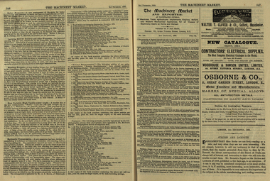
Newspaper, The Machinery Market, 02/12/1889
It's assumed that this journal was read at the Ballarat School of MinesA small illustrated journal with advertisements and pictures. pages 328-356 (and 26 pages of illustrated advertisements). Illustrations include machinery, corn crushers, condensers, chlorination plants. stea, hammers, steam engines, steam pumps, lamps, saw bench, leather belting, casks, barrels, machinery, boiler, cohran and co, birkenhead, stern, cowles syndicate company, electric smelting works, aluminium manufacturing, w t glover and co, rope machine, steam travelling crane, webster wood fibre machine, automatic govenor expansion gear, international exhibition edinburgh, beacon light, air propeller, well boring tools and pumps, cochran and co.'s launch, tug and boat building yard, s.s. jeanette, cochran boiler, cochran and co's boiler shop, stern wheel steamer, s.s. esperanca, cowles syndicate co, milton, w.t. glover & co.'s patent compound rope making machine, bendh drilling machine, steam launch, bicycle, well-boring tools -
 Federation University Historical Collection
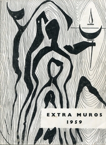
Booklet - Magazine, J.A. Hoskin & Son, Extra Muros, 1959, 1959
The Publications Committee were Ken McDougall, Kath Hayes, Brian Haig, Sue Tucker, heather Bell, Dawn Brown, Ian george, elizabeth Lemmon, Janette Leviston, Leah Harwood, Tony scanlon. Mal Wordsworth. Ian Walshe. The Year Book Committee were Carmel Keys, Judy Krahe, Jill Mayo, and Mr Ryan was the staff representative. The Students' representative council for 1959 were J. O'Neill, I. Ferguson, I. Jenkins, E.Davies, B. Matthews, M. Robinson, R. Cummings, B. Vandenberg, N. Wright, D. McKimmie, K. McDougall, D. Eldridge, N. Beacham, K. Ryrie, J. Rae and D. Wise. The social committee comprised R. Power, G. Briggs, D. Ryan, G. Wallace, V. Delbridge, S. Dawe, Miss Lloyd, Mr Bourke, R. Kelly, M. Grey, J. Cadzow, E. Davies, Monica Miller, G. Commons and F. Mason. A black and white soft covered magazine of the Ballarat Teachers' College. The cover design was by Doug Sheen. Articles include: education in North Borneo, Webster St Hostel, Gillies Street Girls Hostel, Victoria Street Hostel, Camp Street Hostel, Gillies Street Boys Hostel, Ex-Students' association, The Joys of caravaning, How to Spend One's Leisure, Ideas from the Design Club, Faces Behind the Wheel, Life's Bitterness, Characterization, Such is Life. ballarat teachers' college, margaret brown, ken mcdougall, kath hayes, brian haig, tom turner, k. mcdougall, noel beacham, norma mchenry, heather speedie, ted doney, north borneo, webster street hostel, victoria street hostel, students residences, . o'neill, i. ferguson, i. jenkins, e.davies, b. matthews, m. robinson, r. cummings, b. vandenberg, n. wright, d. mckimmie, d. eldridge, n. beacham, k. ryrie, j. rae, d. wise, r. power, g. briggs, d. ryan, g. wallace, v. delbridge, s. dawe, miss lloyd, mr bourke, r. kelly, m. grey, j. cadzow, e. davies, monica miller, g. commons, f. mason, camp street hostel, gillies street hostel