Showing 279 items
matching sub divisions
-
 Ringwood and District Historical Society
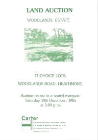
Pamphlet - Land Sales Brochure, Woodlands Estate, Heathmont, 1985
... of Woodlands Road sub division and locality plan on back page. All... on front, one inside plus plan of Woodlands Road sub division ...Bifold pamphlet with picture on front, one inside plus plan of Woodlands Road sub division and locality plan on back page. All in green print. Copy enclosed with handwritten sale prices. Auctioneer's notes (Richard Carter) indicate vendor - Estate of Phoebe Beard.Auction on site in a seated marquee, Saturday 14th December, 1985. Agent - C.E. Carter & Son Pty. Ltd., 122 Whitehorse Road, Ringwood, 3134. Telephone 870 6211. -
 Tatura Irrigation & Wartime Camps Museum
Poster, Tatura Subdivision, 1928
... side as opposed tot he government sub division when Tatura... on Tatura's north side as opposed tot he government sub division when ...Hogans Estate was privately owned land on Tatura's north side as opposed tot he government sub division when Tatura was founded.Large Tatura subdivision poster of 1928 advertising large area north of Hogan Street, named Hogan Estate. Clear plan of subdivisions. Bold print in red and blue.Great subdivision sale. Hogans Estate Tatura. Saturday 18 August 1928. J. McNamara & Co.tatura subdivision, hogans estate -
Whitehorse Historical Society Inc.
Document, Monier Wunderlich Tile Factory, 1989-96
... Papers concerning sub-division of the former Monier... Beryl Papers concerning sub-division of the former Monier ...Papers concerning sub-division of the former Monier-Wunderlich Tile Factory site.Papers concerning sub-division of the former Monier-Wunderlich Tile Factory site between Rooks and Mitcham Roads Vermont. Includes City of Nunawading planning documents and correspondence with residents; Wunderlich Residents' Action Group circulars; correspondence and drafts by W & B Gray relating to the proposals.Papers concerning sub-division of the former Monier-Wunderlich Tile Factory site. wunderlich limited, monier-redlands pty ltd, mitcham road, mitcham, rooks road, vermont, nos. 147-157, wunderlich residents' action group, rosstrevor crescent, mitcham, redlands properties, gray, william, gray, beryl -
 Greensborough Historical Society
Folder, Investors in the Grace Park area - Fricker Brothers 1957, 2018_05
... , and their sub-division and sale between 1957 and 1975. Researched... of Greensborough, and their sub-division and sale between 1957 and 1975 ...Collection of records regarding the acquisition of land by the Fricker brothers in the Grace Park area of Greensborough, and their sub-division and sale between 1957 and 1975. Researched and edited by Peter Simmenauer Folder containing Certificates of Title, photocopies of Death Certificate and Probate documents, list of land sales and historical notes, researched and edited by Peter Simmenauer grace park, fricker avenue greensborough, desmond court greensborough, desmond fricker -
 Warrnambool and District Historical Society Inc.
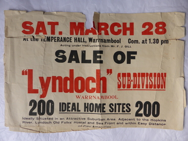
Poster, Lyndoch Sub-Division
... Lyndoch Sub-Division... the surrounding land at a later time. This sub-division came to be known... This is a poster advertising the sale of the Lyndoch sub-division ...This is a poster advertising the sale of the Lyndoch sub-division in Warrnambool with the sale of 200 housing sites. The sale took place about 1958 with the land sold by Frederick Gill, a Warrnambool jeweller. The land was previously owned by George Rolfe who had acquired the land near the mouth of the Hopkins River in the 1880s and named the property ‘Lyndoch’. He bought the surrounding land at a later time. This sub-division came to be known as the Gill Estate. It was a valuable site as many of the allotments fronted the sea and others were adjacent to the Hopkins River. This poster, although tattered, is of interest as it has many details of the Gill Estate sub-division and will be useful to researchers. This is a cream-coloured paper poster with black and red printing. The poster has a small map in a circle shape showing the location of the streets and a larger map section showing the streets and the allotments to be sold. The poster is in two pieces and the edges are torn and, in some sections, missing. The streets map has some pencil annotations. history of warrnambool, lyndoch, warrnambool, george rolfe, frederick gill -
 Greensborough Historical Society
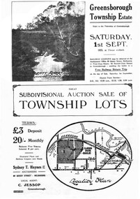
Plan - Digital Image, Greensborough Township Estate, 01/09/1923
... Sub-division into 129 lots of land belonging... Plenty Lower Plenty melbourne Sub-division into 129 lots of land ...Sub-division into 129 lots of land belonging to the Scotland Family, bounded by William Street, Eliza Street, James (Jessop) Street and south of Lorimer Street. Auction 1 September 1923Digital copy of plan. Has been digitally corrected from damaged original.subdivision plans, greensborough township estate, scotland family -
 Greensborough Historical Society
Plan, Greensborough Township Estate, 01/09/1923
... Sub-division into 129 lots of land belonging... Plenty Lower Plenty melbourne Sub-division into 129 lots of land ...Sub-division into 129 lots of land belonging to the Scotland Family, bounded by William Street, Eliza Street, James (Jessop) Street and south of Lorimer Street. Auction 1 September 1923Photocopy, double-sidedsubdivision plans, greensborough township estate, scotland family -
 Phillip Island and District Historical Society Inc.
Newspaper Clipping, 100yrs Celebrations for Phillip Island, 7/11/1968
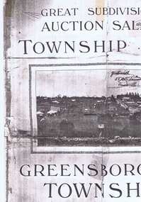
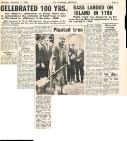
... first sub division of land at Phillip Island. Account of History... of Back to Phillip Island 100yrs after first sub division of land ...Article from a collection of newspaper clippings from October 1968 to July 1971Article about the 100yrs celebrations at Phillip Island in November 1968. Account of Back to Phillip Island 100yrs after first sub division of land at Phillip Island. Account of History of Phillip Island from discovery by Surgeon George Bass on January 5, 1979 to 1922. Account of Historical Display in the Cowes Parish Hall.phillip island, back to phillip island celebrations, surgeon george bass -
 Ringwood and District Historical Society
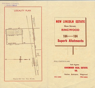
Document - Folder, Land Sale Brochure, New Lincoln Estate, Ringwood, Vic. - circa 1960. Also 1951 newspaper advertisement
... of local facilities and services, locality plan, layout of sub... Ringwood Real Estate (Station Entrance). A sub-divisional plan... Estate (Station Entrance). A sub-divisional plan from CE Carter ...Bi-fold advertisement for sale of residential allotments - New Lincoln Estate, New Street, Ringwood, with summary of local facilities and services, locality plan, layout of sub-division, and price list. Also an advertisement from Ringwood Mail dated 12 July 1951. Subdivision includes New Street, Heywood Street, Barkly Street, Keith Grove, Maurice Avenue, Inez Avenue, Catherine Street, Neville Street, Neale Grove (later Heather Grove), and Sylvia Grove. Agent - Ringwood Real Estate Co., Station Entrance, Ringwood. (Phone) WU 6661, WU 6662.Accompanying handwritten sales notes researched in 2024 by Richard Carter - Carter Real Estate ... "Maurice Ashkanasy KC CMG owned the rectangular estate located between New, Barkly, Heywood Streets and Sylvia Grove in South-West Ringwood. It was given the name "The New Lincoln Estate". It was first advertised around July 1951 as "48 superb allotments", through Ringwood Real Estate (Station Entrance). A sub-divisional plan from CE Carter showed 152 blocks with 60-foot frontages and varying between 110 and 150 feet in length. Later, in 1954 house and land packages were offered through William White in Elsternwick - "Three modern bedrooms, large lounge-dining-room, kitchen with dinette, nicely equipped bathroom - £2,685 to £2,762, deposit £300". The roads were created and named after family members - Neale (later Heather) Grove - after Maurice's son Neal Mark Ashkanasy. The street was later re-named Heather Grove after Maurice's wife, Heather Helen Ashkanasy (Epstein), who passed away in 1999, aged 95. Neville Street - after Marice's other son, Aaron Solomon Neville Ashkanasy known as Neville. Catherine Street and Inez Street - after Heather's mother Catherine Inez Epstein. Maurice Avenue - after Maurice Ashkanasy, vendor. Keith Grove - after Keith Epstein. ..." -
 Whitehorse Historical Society Inc.
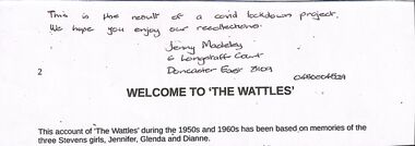
Literary work, The Wattles, 2020
... . The property was sold in the 1960's for sub-division and some farm.... The property was sold in the 1960's for sub-division and some farm ...This account of "The Wattles" during the 1950's and 1960's has been based on memories of the 3 Stevens girls, Jennifer, Glenda and Dianne14 pages and 19.5 x 7 notenon-fictionThis account of "The Wattles" during the 1950's and 1960's has been based on memories of the 3 Stevens girls, Jennifer, Glenda and Dianneblue moon fruit cooperative ltd, mount pleasant methodist church, schwerkolt cottage & museum complex, stevens family -
 Ringwood and District Historical Society
Document, Collection of copies of Maps relating to Wieland Houses and Properties (most undated), plus Document entitle Brian Pump's Orchard and House Locations, 25/2/2008
... and house including sub-divisions. Mostly in Heathmont but also... locations of Wieland properties and house including sub-divisions ...Collection of A4 photocopies of maps and plans, some with yellow highlighting, showing locations of Wieland properties and house including sub-divisions. Mostly in Heathmont but also Scoresby Most pages are undated and do not have original sources Document 28054 entitled Brian Pump's Orchard and House Locations has notes with maps of various houses with numbers corresponding to those on the included maps and also to those in 28054-003 document -
 Melbourne Tram Museum
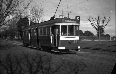
Negative - Set of 2 - Maximum Traction bogie trams Dandenong Road, Wal Jack, c1944
... in Dandenong Road. Appears to be a new sub-division on the other side... in Dandenong Road. Appears to be a new sub-division on the other side ....1 - Black and white negative, by Wal Jack, of C 26 (St Kilda Beach via Dandenong road, Route 67), westbound in Dandenong Road. Appears to be a new sub-division on the other side of the road. .2 - ditto - C 35, note the building in front of the tram in the centre median strip. Photo not dated in the Wal Jack album. Possibly 14-9-42 based on other similar photos.trams, tramways, c class, dandenong road, route 67, tram 35, tram 26, world war ii -
 Kiewa Valley Historical Society
Book - Mt Beauty Voters' Roll, Shire of Bright - Voters' Roll 1979 - Mt Beauty Riding, 1979
... in alphabetical order by surname and first names within each Sub-division... by surname and first names within each Sub-division of an electoral ...Electoral roles list people who are registered and eligible to vote at federal, state, territory and local government elections and referenda. Prior to 1990 the rolls list voters in alphabetical order by surname and first names within each Sub-division of an electoral Division of each State or Territory. The roll is useful and interesting for family historians and the study of demographics.Electoral rolls help to locate the residential address of a person in a particular year or over a period of years. They can be used as a substitute for census records for family historians and the history of a particular place, in this case Mt Beauty. Alex McCullough was a resident of Mt Beauty and Councillor in the Bright Shire. 40 pages of firm blue paper with black typed print on one side only in 'landscape' format. Held by three staples. Each page has columns - numbered 1 to 656; Surnames in alphabetical order; Given names; Occupation; Includes L = 'land'; Address followed by Lot number in the Parish of WermatongOn the cover, top right hand corner "Cr McCullough"shire of bright; mt beauty riding; voters roll; parish of wermatong; alex mccullough -
 Melbourne Tram Museum
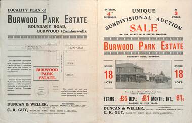
Ephemera - Real estate sale, Duncan & Weller Auctioneers, "Burwood Park Estate" Boundary Road, 1926
... . The plan of sub-division shows 18 lots for sale.... a photo of possibly W 259 at the terminus. The plan of sub ...Pamphlet advertising the sale of land at the Burwood Park Estate, Boundary Road Burwood, Saturday 4th September. Does not give the year, most likely 1926. Promotes the tram service, nearby shops, the suitability of the soil for gardening and other facilities. Has a photo of possibly W 259 at the terminus. The plan of sub-division shows 18 lots for sale.Demonstrates the style of land sale pamphlet including the availability of tram services to prospective purchasers.Pamphlet - folded - printed in two colours of cream coloured paper with photographs and plans.sale of land, trams, real estate, burwood park, burwood -
 Warrnambool and District Historical Society Inc.
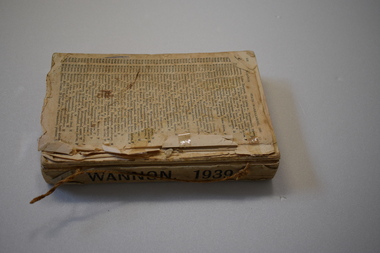
Book - Electoral Roll - Wannon, Electoral Roll
... of boundaries over the years. The sub-divisions in the Wannon... of boundaries over the years. The sub-divisions in the Wannon electorate ...This book contains the names of those on the 1939 electoral roll for Wannon in Victoria. It is an original Federal electorate and was established in 1901. It has had some changes of boundaries over the years. The sub-divisions in the Wannon electorate in 1939 included Branxholme, Casterton, Dimboola, Hamilton, Harrow, Horsham, Horsham South, Jeparit, Koroit, Nhill, Port Fairy, Portland, Stawell and Warrnambool. This book, although tattered and incomplete is a useful one as it has the names of all those on the electoral roll in the Wannon electorate in 1939 and this includes the Warrnambool area. It will be useful to researchers.This is a book containing printed material. It has no cover and is missing several front and back pages. One page at the back is loose and the pages are dog-eared. The book is bound with string. warrnambool 1939, electoral rolls -
 Greensborough Historical Society
Map, Heidelberg: Historic River Landscape Assessment. Historical maps. Map E 1901-1934 "A Time of projects and improvements", 1985c
... to Eltham), rivers and properties, also housing sub-divisions... housing sub-divisions and community facilities such as hospitals ...Geographical area of around 35 sq. kilometres marked with physical features such as major roads, railways (new extension to Eltham), rivers and properties, also housing sub-divisions and community facilities such as hospitals, parks and sporting reserves and indications of new small scale industries such as dairying. Bounded by Shire of Diamond Valley to the North, Darebin Creek to the West and Plenty River to the East. Black and white sketch map on white paperheidelberg, heidelberg - maps -
 Whitehorse Historical Society Inc.
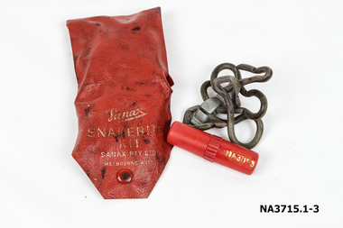
Functional object - Snake Bite Kit, circa 1960's
... problem until the late 1950's when land sub division around... a snake problem until the late 1950's when land sub division ...The Gunning family owned 20 acres of orchard and farm land in High Street Lower Templestowe and kept one of these kits in each vehicle and tractor. They didn't experience a snake problem until the late 1950's when land sub division around their property forced snakes into the area. The family lost one dog to snake bite in the early 1960's.Consists of a Wallet, tourniquet and lancet . 1.Wallet - small red plastic wallet with one press stud to close. Printed in gold on front: 'Sanax Snakebite Kit Sanax Pty Ltd Melbourne Australia 2.Tourniquet - rubber tourniquet looped through a metal clip used to tighten tourniquet. ' Sanax ' embossed on flat of metal clip. 3.Lancet - a three chambered cylindrical container made of red plastic. One end removes to reveal a lancet/ blade, the other end acts as a handle for the blade. Container holds instructions on a small roll of paper. The centre of the container can be be unscrewed to access crystals of permanganate of potash to put on the woundmedicine, first aid -
 Melbourne Tram Museum
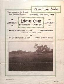
Ephemera - Real estate sale, Arthur Tucett & Son, "Labassa Estate" - Balaclava Road, East St Kilda, Nov. 1913
... at the corner of Orrong Road and Balaclava Road. Has a plan for the sub... at the corner of Orrong Road and Balaclava Road. Has a plan for the sub ...Pamphlet advertising the sale of land at the Labassa Estate, Balaclava Road 29-11-1913. Promotes the tram service, St Kilda Esplanade with a photo of PMTT 15 at the entry to Labassa at the corner of Orrong Road and Balaclava Road. Has a plan for the sub-division in to 46 allotments, terms of sale, and restrictions of what could be built on the land. The original Labassia Mansion is now owned by the National Trust.Demonstrates the style of land sale pamphlet including the availability of tram services to prospective purchasers.Pamphlet - folded - printed in two colours of cream coloured paper with photographs and plans.sale of land, trams, balaclava, balaclava road, real estate, labassa, orrong road -
 Kiewa Valley Historical Society
Book - Kiewa Voters' Roll, Shire of Bright - Voters' Roll 1979 - Kiewa Riding, 1979
... by surnames & first names within each Sub division of an electoral... by surnames & first names within each Sub division of an electoral ...Electoral rolls list people who are registered and eligible to vote at federal, state, territory & local government elections and referenda. Prior to 1990 the rolls list voters in alphabetical order by surnames & first names within each Sub division of an electoral division of each State or Territory. The roll is useful & interesting for family historians and the study of demographics. Alex McCullough lived in the Shire of Bright and was on its Council. Electoral roles help to locate the residential address of a person in a particular year or over a period of years. They can be used as a substitute for census records for family historians and the history of a particular place in this case the Kiewa Valley - Tawonga and Tawonga South.Approx. 60 pages of firm yellow paper with black typed print on one side only in 'landscape' format. Held by three staples. Each page has column - numbered 1 to 943; Surnames in alphabetical order; Given names; Occupation; includes L (=land). Address followed by Lot number and parish. Includes Tawonga and Tawonga SouthOn the cover on the right hand side handwritten and difficult to read - "Jack? / Indi / Benambra / Nth Eastern / Division? of Dawson / 123 Victoria Rd. / Melbourne 3000"shire of bright; kiewa riding; voters roll; alex mccullough; tawonga; tawonga south -
 Bacchus Marsh & District Historical Society
Map - Land Sales Plan, Grantbank Estate Bacchus Marsh, 1924
... to the centre of the shopping area of Bacchus Marsh which was sub.... This was a significant sub-division of land and represented a major expansion ...The Grantbank Estate was a parcel of land close to the centre of the shopping area of Bacchus Marsh which was sub-divided and offered for sale in 58 lots on the 13th September, 1924. It comprised an area of 15 acres, being a portion of the Millbank Estate which had been in the hands of the Grant family for 75 years. The lots had frontages to Gisborne Road, Patterson, William and Sutherland Streets. This was a significant sub-division of land and represented a major expansion of residential housing in Bacchus Marsh in the early 20th century.This land sale map is a typical example of housing estate land sales advertising maps produced by real estate agents in this era. The map is significant for the detailed information it provides about when and where land was sold for new housing estates in Bacchus Marsh in the early twentieth century.Printed paper mapland sales bacchus marsh, land subdivsion bacchus marsh, housing estates land sales bacchus marsh, grant family bacchus marsh -
 Ringwood and District Historical Society
Photograph, Constructing Ringwood East railway station - 1925
... . Photo taken from Ringwood East railway station. Sub-division.... Photo taken from Ringwood East railway station. Sub-division ...Black and white photographs - 2 copies, same sizeTyped below one photograph, "Constructing Ringwood East railway station - 1925". Backing sheet of other photograph reads, "Ringwood East railway station - Higher than Croydon or Ringwood. Photo taken from Ringwood East railway station. Sub-division plan land sale Ringwood East Railway Station Estate 1925?" -
 Warrnambool and District Historical Society Inc.
Document, Register Subdivision WCC, Late 20th century
... streets with sub-division and development information. The lists...: These are twelve photocopied lists of Warrnambool streets with sub-division ...These sheets contain photocopied information on Warrnambool streets and blocks – Allotment numbers and Section numbers, names of developers, date of street construction approval, names of lawyers, Titles Office information etc. They have been originally compiled by Warrnambool City Council staff and concern Warrnambool streets projects from the 1950s, 60s and 70s. This is photocopied material and therefore is of little historical importance. But the information contained therein will be useful for researchers. Document One: These are 57 photocopied pages containing lists of Warrnambool streets and blocks and information on their development. The original information has been handwritten. The pages have been stapled together but the staples have been removed. Document Two: These are twelve photocopied lists of Warrnambool streets with sub-division and development information. The lists have printed plan numbers on the left side and the rest of the information is hand-printed. Two pages have been glued together on one sheet to make six pages. The pages have been stapled together but the staples have been removed. warrnambool streets, warrnambool city council, history of warrnambool -
 Warrnambool and District Historical Society Inc.
Map, Plans (5) showing Subdivisions of Warrnambool, 1989
... These are five hand-drawn sheets showing plans of sub... plans of sub-divisions in Warrnambool streets in 1989 ...These plans have been drawn by Steve Hester for the Warrnambool City Council to illustrate the allotments in Warrnambool concerned with the subdivisions of 1989. The streets have not been named but there is an indication of the area with the identification of known buildings (eg Hospital) and the plan numbers of each allotment is clearly marked. These numbers corresponded to the plan numbers registered in card files and ledgers in the Warrnambool City Council offices. The scale of the plans was 1 to 5000. These plans are of considerable interest because they show Warrnambool street subdivisions of 1989 in illustrative form. They show how information was collated in the late 1980s before the widespread use of computer digital means to describe and store information.These are five hand-drawn sheets showing plans of sub-divisions in Warrnambool streets in 1989 (Warrnambool City Council material). The plans are multi-coloured (crayons) and show allotments with plan numbers. The first plan has much of the material torn off but the location is known to be in the Russells Creek area. Some of the green tape around the edges is missing. Plans two to five are almost intact and are bound with green tape. Plan Two- Industrial Estate of West Warrnambool; Plan Three – Hospital/Merrivale/ Lake Pertobe areas; Plan Four – North Warrnambool, Wollaston/Brierly areas; Plan Five – Flaxman Street area. ‘Subdivision Plan, Reference Guide, Steve Hester, Oct. 1989’. warrnambool street subdivisions, steve hester, history -
 Ballarat Tramway Museum
Pamphlet - Real Estate, T M Burke Pty Ltd, "Tram Extensions Authorised", 1936
... , shows the extensive sub-divisions where land was available... Estate agents, shows the extensive sub-divisions where land ...Wal Jack collected tramway and railway items for his collection. This pamphlet gives details of the Melbourne Public Transport system - rail, tram and bus in late 1936. Issued by T M Burke Pty Ltd of 840 Collins St Melbourne, Real Estate agents, shows the extensive sub-divisions where land was available for purchase and notes the MMTB authorisation of new tram routes. Gives details of the T M Burke services. Routes shown as authorised (16-7-1936) are: Keilor Road Essendon, High St North Balwyn and Hawthorn Road East Brighton. Demonstrates a Real Estate Sales pamphlet.Pamphlet - four colours printed on cream coloured bond paper, folded vertically originally.letter, wal jack, buninyong, railway lines -
 Eltham District Historical Society Inc
Photograph, View at Eltham, Vic, c.1924
... was created as part of the sub-division. Most of the sub-division... was created as part of the sub-division. Most of the sub-division ...Copy of possible Rose Stereograph Co. postcard “View at Eltham, Vic.”, c.1924 looking southwest from Main Road near York Street to Bridge Street and the original 1875 bridge across what is now the Alistair Knox Park The land in the foreground was first bought from the Crown by J.M. Holloway in 1851. The land was sub-divided and called "Little Eltham". Bridge Street was created as part of the sub-division. Most of the sub-division was residential lots but the creek valley was divided into lots for small farms. Council started to buy the land for the Eltham Town park in the early 1960s. The area was used as a garbage tip and filled above the flood plain of the creek. Development of the land for a park began in the early 1970s. The house on the right was owned for many years by the Hill family until Council bought it in the early 1960s. The house was built in the 1850s or 60s. The house on the left stood on what is now the southwest corner of Susan and Bridge Streets. The Braithwaite family was associated with this house. The double line of fencing in the foreground was a continuation of York Street to the creek. The Bridge Street bridge was built in 1875 and replaced in 1958. (Ref: Early view of Little Eltham; Byways of History by Colleen Ison, Publication unk, 24 August 1982) Reproduced on p61 of 'Pioneers & Painters' Date estimated on same as View at Hurstbridge featuring Wattle Valley EstateThis photo forms part of a collection of photographs gathered by the Shire of Eltham for their centenary project book,"Pioneers and Painters: 100 years of the Shire of Eltham" by Alan Marshall (1971). The collection of over 500 images is held in partnership between Eltham District Historical Society and Yarra Plenty Regional Library (Eltham Library) and is now formally known as the 'The Shire of Eltham Pioneers Photograph Collection.' It is significant in being the first community sourced collection representing the places and people of the Shire's first one hundred years.Digital image 120 format B&W negative Prints 17 x 25 cm and 10 x 15 cmsepp, shire of eltham pioneers photograph collection, eltham, bridge street, bridge, alistair knox park, braithwaite, bridge street bridge, eltham town park, hill family home, main road, pioneers and painters, york street -
Surrey Hills Historical Society Collection
Folder of information, Libby Cavenagh's 1990 building census of Wandsworth Road, Surrey Hills, 1990
... from Land Titles Office showing sub-division information; land... showing sub-division information; land auction advertisements ...Libby Cavenagh was Secretary of the Surrey Hills Historical Society. She completed this study as part of a Diploma of Local History she was undertaking at the University of New England. At the time she lived in Wandsworth Road.This is a unique analysis of the housing stock of a complete street at one point in time. Many of the houses have been altered since the study was completed and quite a number have been demolished.Blue folder of A4 size. This contains an analysis of each house in Wandsworth Road in 1990 with details regarding building style, approximate age, materials used, fence design, presence or absence of a garage or carport and some comment on the garden elements. For most entries there is a coloured photo taken from the street. For some there are photocopies of real estate advertisements. There are a number of appendices including s a map of the breakdown of styles and materials; date of construction and other information from the Camberwell Building registers 1890-1934; entries re owners from Sands & McDougall directories, 1897-1937; map from Land Titles Office showing sub-division information; land auction advertisements; information re W J Vine; list of builders; references.wandsworth road, libby cavenagh -
 Melbourne Tram Museum
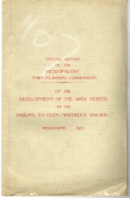
Document - Report, Metropolitan Town Planning Commission, "Metropolitan Town Planning Commission - Darling to Glen Waverley Railway - 1927", May. 1927
... existing sub-divisions. Note that Mr. Strickland was a member... existing sub-divisions. Note that Mr. Strickland was a member ...Report - 20 pages + 5 Maps stapled and then glued bound within a light green grey light card folder titled "Metropolitan Town Planning Commission - Special Report on the Development of the area serviced by the Darling to Glen Waverley Railway - 1927". Report looks the development that could be undertaken along the proposed Glen Waverley rail line, its town planning, Garden City type layouts, rail level crossings, new arterial roads, open spaces, financial arrangements, sewerage and water supply, zoning, legislation and conclusion. Dated 6/5/1927. Plans show possible garden city type layouts, arterial roads, possibilities within existing sub-divisions. Note that Mr. Strickland was a member of the Commission undertaking this work.Has in ink on the bottom edge "17th June 1919"trams, tramways, mmtb, tramways, development, town planning, glen waverley, darling -
 Ringwood and District Historical Society
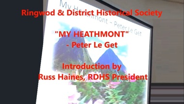
Mixed media - Video, RDHS Guest Speaker Presentation - "My Heathmont" - Peter Le Get
... their properties, which led to the sub-division of land into housing blocks... to sell their properties, which led to the sub-division of land ...Digitised video (5.14GB). Duration: 61 minutes. Recorded May, 2018. (Video is available for viewing at Ringwood & District Historical Society Archives by appointment)Presenter: Peter Le Get, together with his wife, Mary, have been one of the few families to purchase, and live in, four homes in the suburb of Heathmont. The Le Get’s came to Heathmont when pioneer orchardists were beginning to sell their properties, which led to the sub-division of land into housing blocks. It was the time of a new community coming together, with sporting clubs starting up, churches and schools built, roads being defined or asphalted, and the proliferation of new shops and businesses. -
 Warrnambool and District Historical Society Inc.
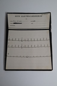
Document - "Both" Electrocardiogram printout, 4 Jul 1939
... . He was Secretary of the Victorian South West sub-division.... He was Secretary of the Victorian South West sub-division ...In 1932, Edward Thomas Both invented the first portable direct reading electro cardiograph. This item is a three lead electrocardiograph tracing conducted on one of Dr Angus' patients in 1939. Dr William Roy Angus (1901-1970) came to Warrnambool in 1939, purchasing the general practice of Dr John Hunter Henderson. He was the last serving Warrnambool Port Medical Officer. A health problem after the war prompted a change from general practice to ophthalmology. Dr. Angus became an important ophthalmologist , pioneering the use of the intrascleral cartilage implant which resulted in cosmetically better artificial eyes. He was an Honorary Consultant Ophthalmologist at Warrnambool Base Hospital for 31 years. He was Secretary of the Victorian South West sub-division of the Australian Medical Association from 1949 to 1956 and Chairman from 1956 to 1958. His obituary in the Medical Journal of Australia (July 1970) stated he was "dedicated and devoted to both his profession and his patients" .This item provides a link to an Australian invention of medical equipment which improved diagnosis and treatment of heart conditions in the 1930's. It is an example of diagnostic recordings used by a Warrnambool doctor in 1939.This is a card record of a three lead "Both" Electrogram. The upper one third has places for the date patient details and diagnosis. There are three electrocardiogram tracings over graph paper in the bottom two thirds of the item. The reverse side has a handwritten in ink interpretation of the tracings.Front: BOTH ELECTRO-CARDIOGRAM No. Date July 4th 1939 Rate 130 Name Age Diagnosis The patient name has been blacked out. Dr. Angus is printed in the top right hand corner. Rear: The P wave in lead 1 is broadened and notched, and has a suggestive "plateau" top. This may indicate a mitral stenosis, auricular hypertrophy. E Bannondr william roy angus, both electro-cardiogram, dr angus collection -
 Victoria Police Museum
Police Stations (Armadale)
... closed on 28 January 1946. The sub-division east of Orrong Rd... closed on 28 January 1946. The sub-division east of Orrong Rd ...Armadale is an inner suburb of Melbourne, Victoria, Australia, 7 km south-east of Melbourne's Central Business District, located within the City of Stonnington local government area. Armadale Police Station opened, in Melbourne Police District, on 11 May 1885. Its original location is unknown, but in 1890 it is listed in the Sands & McDougall directory as at 295 Hight Street. From 1985-1920 it was located at 20/22 Auburn Grove, 1925-1930 at 769 High Street and 1935-1946 at 3 Cheel Street. The station closed on 28 January 1946. The sub-division east of Orrong Rd was incorporated into Malvern Sub-district and west of Orrong Road into Prahran Sub-district. In a special 1930 issue of the Victoria Police Gazette the Armadale Police Station was described as a seven-roomed brick dwelling with a tiled roof on land measuring 127' x 104' x 98'. There was also a bathroom and W.C., a wash-house, office, and a lock-up (one cell). This is probably a description of the Cheel Street police station. It was staffed by one senior constable and three foot constables.12 photographs comprising 8 coloured images and 4 black and white images 1 sketch plan of Old Armadale Police Stationpolice stations; armadale police station