Showing 148 items
matching act of parliament
-
 Bendigo Historical Society Inc.
Document - BASIL MILLER COLLECTION: TRAMS - TRAMWAYS ACT - VICTORIA
... Booklet, Act of the Victorian Parliament, No. 3845... PERSON Individual basil miller Booklet, Act of the Victorian ...Booklet, Act of the Victorian Parliament, No. 3845, to provide for the construction of Tramways and the management and operation of Tramway undertakings by the State Electricity Commission of Victoria....enacted 30th December 1929. Stamped in purple 16th Jan, 1929, State Electricity Commission of Victoria, Ballarat. 15 pages.person, individual, basil miller -
 Melbourne Tram Museum
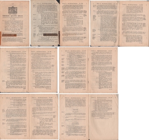
Document - Personal Papers, Victorian Parliament, "Grant of certain Lands etc.", 1959
... Act of Victorian Parliament, 8 pages, No. 6594 - "An Act... Footscray Rd Construction Act of Victorian Parliament, 8 pages ...Act of Victorian Parliament, 8 pages, No. 6594 - "An Act to provide for the Grant of certain Lands to the After Care Hospital, the Melbourne District Nursing Service, the Victorian Civil Ambulance Service, St Georges Hospital, the Royal Talbot Colony for Epileptics, the Ballarat Orphanage and the Melbourne and Metropolitan Tramways Board respectively. Page 4 and 7 detail a block of land that the Board could have purchased for a major bus depot in Footscray Road for 60,175 pounds.trams, tramways, tramways, acts of parliament, mmtb, buses, depot, footscray rd, construction -
 Kew Historical Society Inc
Map, MMBW, MMBW Town of Kew, 1910-21
... ) was established by an act of the Victorian Parliament in 1890 to prepare... by an act of the Victorian Parliament in 1890 to prepare ...The Melbourne and Metropolitan Board of Works (MMBW) was established by an act of the Victorian Parliament in 1890 to prepare for and to implement a sewerage and water reticulation system across what was then inner Melbourne, its surrounding and middle distance suburbs, including Kew. The MMBW was disbanded in 1991.The map collection of the Kew Historical Society has at its core the historic maps assembled and originally stored in the City Engineer's Department of the City of Kew. These include maps in a number of scales. The vast majority of maps were produced by the MMBW in the first two decades of the twentieth century, and are solid working maps, backed by linen for durability. These maps are historically significant to Kew, the City of Boroondara and to the history of the development of state utilities in Victoria. A number of the Kew maps have additional details added by former municipal officers, including the levels reached by various floods. As these were working documents, information was added to them long after the period of their initial production and distribution.Early map of the Town of Kew, created after 1910, at a scale 440 ft to 1 inch. The 'assembled' map by the City of Kew Engineer's Department includes scaled down copies of The Melbourne and Metropolitan Board of Works maps, Nos. 39, 40, 64, 65, 66, 67, 68, and 117. The map covers the entirety of the Town of Kew, bordered on its north and west by the River Yarra, by Burke Road in the East and Barkers Road in the south. The map shows the extent of urban development by that time, prominent institutions and the outlines of built structures in the municipality. TOWN OF KEW / SCALE 400 FEET TO 1 INCHmelbourne & metropolitan board of works, mmbw maps, mmbw plans, town of kew, cartography -
 Kew Historical Society Inc
Map, MMBW, MMBW Plan No.39 Kew & Heidelberg, 1900-1910
... ) was established by an act of the Victorian Parliament in 1890 to prepare... by an act of the Victorian Parliament in 1890 to prepare ...The Melbourne and Metropolitan Board of Works (MMBW) was established by an act of the Victorian Parliament in 1890 to prepare for and to implement a sewerage and water reticulation system across what was then inner Melbourne, its surrounding and middle distance suburbs, including Kew. The MMBW was disbanded in 1991.The map collection of the Kew Historical Society has at its core the historic maps assembled and originally stored in the City Engineer's Department of the City of Kew. These include maps in a number of scales. The vast majority of maps were produced by the MMBW in the first two decades of the twentieth century, and are solid working maps, backed by linen for durability. These maps are historically significant to Kew, the City of Boroondara and to the history of the development of state utilities in Victoria. A number of the Kew maps have additional details added by former municipal officers, including the levels reached by various floods. As these were working documents, information was added to them long after the period of their initial production and distribution.Early map of part of the Borough of Kew, created in the first decade of the twentieth century, at a scale 160 ft to 1 inch. The map covers what was then the north western section of Kew, bordered on its north by Wills Street and the Kew Lunatic Asylum, in the west by the River Yarra [and the later added Yarra Boulevard] , by Princess Street in the East and Holroyd Street in the south. The map shows the extent of urban development by that time, prominent institutions and the outlines of built structures in the municipality. Contour lines were added in ink to the map at a later stage.MELBOURNE AND METROPOLITAN BOARD OF WORKS / PLAN NO. 39 / KEW & HEIDELBERGmelbourne & metropolitan board of works, mmbw maps, mmbw plans, borough of kew, cartography -
 Kew Historical Society Inc
Map, MMBW, MMBW Plan No.40 Collingwood & Kew, 1900-1910
... ) was established by an act of the Victorian Parliament in 1890 to prepare... by an act of the Victorian Parliament in 1890 to prepare ...The Melbourne and Metropolitan Board of Works (MMBW) was established by an act of the Victorian Parliament in 1890 to prepare for and to implement a sewerage and water reticulation system across what was then inner Melbourne, its surrounding and middle distance suburbs, including Kew. The MMBW was disbanded in 1991.The map collection of the Kew Historical Society has at its core the historic maps assembled and originally stored in the City Engineer's Department of the City of Kew. These include maps in a number of scales. The vast majority of maps were produced by the MMBW in the first two decades of the twentieth century, and are solid working maps, backed by linen for durability. These maps are historically significant to Kew, the City of Boroondara and to the history of the development of state utilities in Victoria. A number of the Kew maps have additional details added by former municipal officers, including the levels reached by various floods. As these were working documents, information was added to them long after the period of their initial production and distribution.Early map of part of the Borough of Kew, created in the first decade of the twentieth century, at a scale 160 ft to 1 inch. The map covers what was then the south western section of Kew, bordered on its north by Studley Park Road, in the west by Walmer Street and the River Yarra, by High Street South and Princess Street in the East and Barkers Road in the south. The map shows the extent of urban development by that time, prominent institutions and the outlines of built structures in the municipality. Contour lines and historic flood levels were added in ink to the map at a later stage.MELBOURNE AND METROPOLITAN BOARD OF WORKS / PLAN NO. 40 / COLLINGWOOD & KEWmelbourne & metropolitan board of works, mmbw maps, mmbw plans, borough of kew, cartography -
 Kew Historical Society Inc
Map, MMBW, MMBW Plan No.64 Kew & Heidelberg, 1900-1910
... ) was established by an act of the Victorian Parliament in 1890 to prepare... by an act of the Victorian Parliament in 1890 to prepare ...The Melbourne and Metropolitan Board of Works (MMBW) was established by an act of the Victorian Parliament in 1890 to prepare for and to implement a sewerage and water reticulation system across what was then inner Melbourne, its surrounding and middle distance suburbs, including Kew. The MMBW was disbanded in 1991.The map collection of the Kew Historical Society has at its core the historic maps assembled and originally stored in the City Engineer's Department of the City of Kew. These include maps in a number of scales. The vast majority of maps were produced by the MMBW in the first two decades of the twentieth century, and are solid working maps, backed by linen for durability. These maps are historically significant to Kew, the City of Boroondara and to the history of the development of state utilities in Victoria. A number of the Kew maps have additional details added by former municipal officers, including the levels reached by various floods. As these were working documents, information was added to them long after the period of their initial production and distribution.Early map of part of the Borough of Kew, created in the first decade of the twentieth century, at a scale 160 ft to 1 inch. The map covers what was then the northern most part of Kew, bordered on its north and west by the Yarra River, in the East by Connor's Creek and by the Asylum in the south. The map shows the extent of urban development by that time, prominent institutions and the outlines of built structures in the municipality. Contour lines and historic flood levels were added in ink to the map at a later stage.MELBOURNE AND METROPOLITAN BOARD OF WORKS / PLAN NO. 64 / KEW & HEIDELBERGmelbourne & metropolitan board of works, mmbw maps, mmbw plans, borough of kew, cartography -
 Kew Historical Society Inc
Map, MMBW, MMBW Plan No.65 Kew & Heidelberg, 1900-1910
... ) was established by an act of the Victorian Parliament in 1890 to prepare... by an act of the Victorian Parliament in 1890 to prepare ...The Melbourne and Metropolitan Board of Works (MMBW) was established by an act of the Victorian Parliament in 1890 to prepare for and to implement a sewerage and water reticulation system across what was then inner Melbourne, its surrounding and middle distance suburbs, including Kew. The MMBW was disbanded in 1991.The map collection of the Kew Historical Society has at its core the historic maps assembled and originally stored in the City Engineer's Department of the City of Kew. These include maps in a number of scales. The vast majority of maps were produced by the MMBW in the first two decades of the twentieth century, and are solid working maps, backed by linen for durability. These maps are historically significant to Kew, the City of Boroondara and to the history of the development of state utilities in Victoria. A number of the Kew maps have additional details added by former municipal officers, including the levels reached by various floods. As these were working documents, information was added to them long after the period of their initial production and distribution.Early map of part of the Borough of Kew, created in the first decade of the twentieth century, at a scale 160 ft to 1 inch. The map covers what was then the south central part of Kew, bordered on its north by Malmsbury Street, in the west by Florence Avenue, in the south by Barkers Road, and in the east by Princess Street. The map shows the extent of urban development by that time, prominent institutions and the outlines of built structures in the municipality. Contour lines were added in ink to the map at a later stage.MELBOURNE AND METROPOLITAN BOARD OF WORKS / PLAN NO. 65 / KEW & HEIDELBERGmelbourne & metropolitan board of works, mmbw maps, mmbw plans, borough of kew, cartography -
 Kew Historical Society Inc
Map, MMBW, MMBW Plan No.66 Kew, 1900-1910
... ) was established by an act of the Victorian Parliament in 1890 to prepare... by an act of the Victorian Parliament in 1890 to prepare ...The Melbourne and Metropolitan Board of Works (MMBW) was established by an act of the Victorian Parliament in 1890 to prepare for and to implement a sewerage and water reticulation system across what was then inner Melbourne, its surrounding and middle distance suburbs, including Kew. The MMBW was disbanded in 1991.The map collection of the Kew Historical Society has at its core the historic maps assembled and originally stored in the City Engineer's Department of the City of Kew. These include maps in a number of scales. The vast majority of maps were produced by the MMBW in the first two decades of the twentieth century, and are solid working maps, backed by linen for durability. These maps are historically significant to Kew, the City of Boroondara and to the history of the development of state utilities in Victoria. A number of the Kew maps have additional details added by former municipal officers, including the levels reached by various floods. As these were working documents, information was added to them long after the period of their initial production and distribution.Early map of part of the Borough of Kew, created in the first decade of the twentieth century, at a scale 160 ft to 1 inch. The map covers what was then the south eastern part of Kew, bordered on its north by Adeney Avenue, in the west by Sackville Street, in the south by Barkers Road, and in the east by Burke Road. The map shows the extent of urban development by that time, prominent institutions and the outlines of built structures in the municipality. Contour lines were added in ink to the map at a later stage.MELBOURNE AND METROPOLITAN BOARD OF WORKS / PLAN NO. 66 / KEW melbourne & metropolitan board of works, mmbw maps, mmbw plans, borough of kew, cartography -
 Kew Historical Society Inc
Map, MMBW, MMBW Plan No.67 Kew, 1900-1910
... ) was established by an act of the Victorian Parliament in 1890 to prepare... by an act of the Victorian Parliament in 1890 to prepare ...The Melbourne and Metropolitan Board of Works (MMBW) was established by an act of the Victorian Parliament in 1890 to prepare for and to implement a sewerage and water reticulation system across what was then inner Melbourne, its surrounding and middle distance suburbs, including Kew. The MMBW was disbanded in 1991.The map collection of the Kew Historical Society has at its core the historic maps assembled and originally stored in the City Engineer's Department of the City of Kew. These include maps in a number of scales. The vast majority of maps were produced by the MMBW in the first two decades of the twentieth century, and are solid working maps, backed by linen for durability. These maps are historically significant to Kew, the City of Boroondara and to the history of the development of state utilities in Victoria. A number of the Kew maps have additional details added by former municipal officers, including the levels reached by various floods. As these were working documents, information was added to them long after the period of their initial production and distribution.Early map of part of the Borough of Kew, created in the first decade of the twentieth century, at a scale 160 ft to 1 inch. The map covers what was then the north central part of Kew, bordered on its north by the Outer Circle Railway Spruzen and Beresford Avenues, in the west by Princess Street, in the south by High Street, and in the east by (about) Belford Road. The map shows the extent of urban development by that time, prominent institutions and the outlines of built structures in the municipality. Contour lines were added in ink to the map at a later stage.MELBOURNE AND METROPOLITAN BOARD OF WORKS / PLAN NO. 67 / KEW melbourne & metropolitan board of works, mmbw maps, mmbw plans, borough of kew, cartography -
 Kew Historical Society Inc
Map, MMBW, MMBW Plan No.68 Kew, 1900-1910
... ) was established by an act of the Victorian Parliament in 1890 to prepare... by an act of the Victorian Parliament in 1890 to prepare ...The Melbourne and Metropolitan Board of Works (MMBW) was established by an act of the Victorian Parliament in 1890 to prepare for and to implement a sewerage and water reticulation system across what was then inner Melbourne, its surrounding and middle distance suburbs, including Kew. The MMBW was disbanded in 1991.The map collection of the Kew Historical Society has at its core the historic maps assembled and originally stored in the City Engineer's Department of the City of Kew. These include maps in a number of scales. The vast majority of maps were produced by the MMBW in the first two decades of the twentieth century, and are solid working maps, backed by linen for durability. These maps are historically significant to Kew, the City of Boroondara and to the history of the development of state utilities in Victoria. A number of the Kew maps have additional details added by former municipal officers, including the levels reached by various floods. As these were working documents, information was added to them long after the period of their initial production and distribution.Early map of part of the Borough of Kew, created in the first decade of the twentieth century, at a scale 160 ft to 1 inch. The map covers what was then the north central part of Kew, bordered in the north by Oak Avenue, in the west by the Yarra River and Connor's Creek, in the south by Beresford and Carnegie Avenues, and in the east by Glass's Creek and Burke Road. The map shows the extent of urban development by that time, prominent institutions and the outlines of built structures in the municipality. Contour lines and the levels of historic floods were added in ink to the map at a later stage.MELBOURNE AND METROPOLITAN BOARD OF WORKS / PLAN NO. 68 / KEW melbourne & metropolitan board of works, mmbw maps, mmbw plans, borough of kew, cartography -
 Kew Historical Society Inc
Map, MMBW, MMBW Plan No.117 Heidelberg & Kew, 1900-1910
... ) was established by an act of the Victorian Parliament in 1890 to prepare... by an act of the Victorian Parliament in 1890 to prepare ...The Melbourne and Metropolitan Board of Works (MMBW) was established by an act of the Victorian Parliament in 1890 to prepare for and to implement a sewerage and water reticulation system across what was then inner Melbourne, its surrounding and middle distance suburbs, including Kew. The MMBW was disbanded in 1991.The map collection of the Kew Historical Society has at its core the historic maps assembled and originally stored in the City Engineer's Department of the City of Kew. These include maps in a number of scales. The vast majority of maps were produced by the MMBW in the first two decades of the twentieth century, and are solid working maps, backed by linen for durability. These maps are historically significant to Kew, the City of Boroondara and to the history of the development of state utilities in Victoria. A number of the Kew maps have additional details added by former municipal officers, including the levels reached by various floods. As these were working documents, information was added to them long after the period of their initial production and distribution.Early map of part of the Borough of Kew, created in the early twentieth century, at a scale 160 ft to 1 inch. The map covers what was then the north eastern part of Kew showing the natural landscape and limited development on the south side of the Yarra River. In the Kew section, south of the river, the land is occupied currently by the Greenacres and Kew Golf Clubs. The map shows the extent of urban development by that time and the outlines of the few built structures in the municipality. The height above sea level of all parts of the landscape are indicated numerically in feet. Contour lines and the levels of historic floods were added in ink to the map at a later stage. MELBOURNE AND METROPOLITAN BOARD OF WORKS / PLAN NO. 117 / HEIDELBERG & KEW melbourne & metropolitan board of works, mmbw maps, borough of kew, cartography, mmbw plan no. 117, kew (vic.) -- maps, heidelberg (vic.) -- maps -
 Kew Historical Society Inc
Map, MMBW, River Yarra Beautification Schemes, c.1913
... ) was established by an act of the Victorian Parliament in 1890 to prepare... by an act of the Victorian Parliament in 1890 to prepare ...The Melbourne and Metropolitan Board of Works (MMBW) was established by an act of the Victorian Parliament in 1890 to prepare for and to implement a sewerage and water reticulation system across what was then inner Melbourne, its surrounding and middle distance suburbs, including Kew. The MMBW was disbanded in 1991.The map collection of the Kew Historical Society has at its core the historic maps assembled and originally stored in the City Engineer's Department of the City of Kew. These include maps in a number of scales. The vast majority of maps were produced by the MMBW in the first two decades of the twentieth century, and are solid working maps, backed by linen for durability. These maps are historically significant to Kew, the City of Boroondara and to the history of the development of state utilities in Victoria. A number of the Kew maps have additional details added by former municipal officers, including the levels reached by various floods. As these were working documents, information was added to them long after the period of their initial production and distribution.Map of the City of Kew showing part of the River Yarra Beautification Schemes. The map shows development to date and the flood levels reached in 1923 and 1924. This map may have been adapted from an earlier map, as most development in central Kew and Studley Park had occurred by this date yet numerous streets are not represented. Public buildings and institutions are clearly represented and named on the map as are significant public transport infrastructure (eg the Outer Circle railway).MELBOURNE AND METROPOLITAN BOARD OF WORKS / RIVER YARRA BEAUTIFICATION SCHEMES / SCHEME / SCALE 10 CHAINS TO AN INCHmelbourne & metropolitan board of works, mmbw maps, mmbw plans, city of kew, flood levels -- kew (vic.), cartography -
 Melbourne Tram Museum
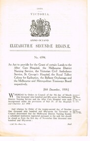
Document - Personal Papers, Victorian Parliament, "An Act to consolidate the Law relating to Metropolitan Tramways", 1958
... Act of Victorian Parliament, 94 pages (was printed as 96... Trams tramways Tramways ACTs of Parliament MMTB Construction Act ...Act of Victorian Parliament, 94 pages (was printed as 96), 3 sections, stapled on the left hand side , No. 6311 - "An Act to consolidate the Law relating to Metropolitan Tramways", dated 30/9/1958. Consolidates the various MMTB Acts to 1958. Mr. McComb has kept the document up to date, and made changes to the document in red ink with notes and crossed out those sections which have been repealed in green pencil. See Reg Item 2120 for the 1929 reprint.trams, tramways, tramways, acts of parliament, mmtb, construction -
 Greensborough Historical Society
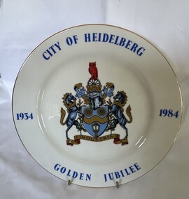
Decorative object - Commemorative Plate, Westminster, City of Heidelberg Golden Jubilee - 1934-1984, 1984
... seal of the City. The municipality was declared a City by Act... seal of the City. The municipality was declared a City by Act ...A strictly limited edition produced for the Rotary Club of Heidelberg, Australia' for the celebration of the Golden Jubilee of the City of Heidelberg (now City of Banyule).China plate with gilt edging; wording City of Heidelberg, Golden Jubilee,1934-1984 borders around the plate with the crest placed in the middle. "City of Heidelberg Golden Jubile1934-1984" with Coat of Arms. Underside Rotary International Crest; Fine China, Westminster Australia. The story of: 'Coat of Arms - The carriage wheels and lamp commemorate the early beginnings of the City about 1840 when the Heidelberg Road Trust was the local authority; the wavy band and wattle blossom are symbolic of the River Yarra, whilst the supporters represent the customary mode of transport at the time. The mural crown is the emblem of local government and these perpetuate the distinctive record of the City of Heidelberg in having the first suburban form of local Government of the Colony. An owl, the symbol of wisdom, is also embodied in the crest as our City is named after Heidelberg in Germany whose University founded in AD 1386, became one of the most famous seats of learning. The motto "Industrica" provides a link with the early seal of the City. The municipality was declared a City by Act of Parliament on April 11, 1934.'city of heidelberg, heidelberg, commemorative items, city of banyule -
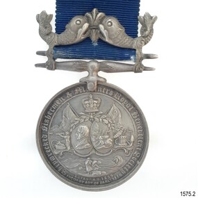 Flagstaff Hill Maritime Museum and Village
Award - Medal, Stokes, c 1882
... in November 1838. The Society was incorporated by an Act of Parliament... by an Act of Parliament in 1850. The Society’s flag is the St ...This medal was presented by the Shipwrecked Fishermen and Mariners' Royal Benevolent Society and was posthumously awarded to Captain John Coffey’s family for his efforts at saving life at sea, in 1882. Captain Coffey lost his life in this attempt. The shipwreck occurred between Australia and England. The included letter was written by the donor, who is the grandson of John Coffey. It is interesting that the medal and note were packaged in a small tin whose original purpose was to present a wedding cake gift to guests. The container is decorated with wedding bells pressed into the lid. Shipwrecked Fishermen and Mariners’ Royal Benevolent Society: - The Shipwrecked Mariners (Shipwrecked Fishermen and Mariners’ Royal Benevolent Society) is a national charity established in 1839. It is run by a network of volunteers in the UK and Ireland. The organisation assists former mariners, their dependants and their families. John Rye and his servant Charles-Gee Jones, of Bath, UK, encouraged its formation after a severe storm caused the loss of life from the ‘Clovelly’ fishing fleet in November 1838. The Society was incorporated by an Act of Parliament in 1850. The Society’s flag is the St George’s Cross, a red cross on a white background and a gold crown in the centre, with the letters S F M S displayed, one in each quadrant. Nominations are made by members each year of those who have performed outstanding acts of bravery in helping those in peril in the sea. The inscription on the reverse "PRESENTED FOR HEROIC EXERTIONS IN SAVING LIFE FROM DROWNING / JOB XXIX 13" refers to a verse in the Bible, which in the King James version reads "The blessing of him that was ready to perish came upon me; and I caused the widow's eart to sing for joy."This is the only medal in our collection awarded from the Shipwrecked Fishermen and Mariners' Royal Benevolent Society. Medal, silver with blue ribbon. The obverse of the medal has images of the British flag, a crown flag with "S.F.", a portrait of a man, a shipwreck, a cannon and anchor, a man with a telescope, and two people attending a body on the shore. The reverse of the medal has text. The medal clasp depicts a fleur de lies between two fish. The medal maker is Stokes. The metal was donated in a tin container and included a letter. The medal was presented posthumously to the family of Captain John Coffey for his efforts at saving life at sea, in 1882. It has an accompanying letter and container.On rim "CAPTAIN JOHN COFFEY - 1882" Obverse "SHIPWRECKED FISHERMEN AND MARINERS ROYAL BENEVOLENT SOCIETY" and "ESTAB AD 1839 INCOd BY ACT OF PARLt 1850" Reverse "PRESENTED FOR HEROIC EXERTIONS IN SAVING LIFE FROM DROWNING / JOB XXIX 13" and "ENGLAND EXPECTS EVERY MAN WILL DO HIS DUTY" The tin box has "MEDAL" handwritten in black.flagstaff hill, flagstaff hill maritime museum and village, warrnambool, maritime museum, maritime village, great ocean road, shipwreck coast, medal, captain john coffey, john coffey, numismatics, hero, saving lives, shipwrecked fishermen and mariners’ royal benevolent society, sfms, shipwrecked mariners' society -
 Melbourne Legacy
Photograph, Hibernian Hall, 30/6/1947
... building was required. An act of parliament was required to enable... building was required. An act of parliament was required to enable ...A photo of the first property owned by Legacy, at 342 Swanston Street. After receiving money in memory of David H Dureau to purchase premises, Legacy purchased the old Hibernian Hall. However there were many issues with the property, including its suitability and the inability to gain vacant possession from the existing tenants. So eventually the property was sold and the money used to buy the current Legacy House, still formally known as the David H Dureau Memorial Building as per the bequest instructions. The notes on the back of the photo say it was sold to Sir Bernard Evans and then to RMIT and it was renamed Storey Hall. The full story of the donation has been pieced together from several sources. Part of the story of the donation towards Dureau House. BG Corporation in New York used 'Brown and Dureau' as agents in Melbourne for their spark plug manufacturing (for the American aircraft based in Australia during the war). A royalty of two shillings and sixpence was agreed. The entrepreneur President of BG Corporation was Richard Goldsmith. L/ Grat Grattan had a friend Mr Edwards who was managing director at Brown and Dureau and heard of the desire by Mr Goldsmith to leave a permanent memorial to ex-servicemen in Australia (Children's Hospital was considered). L/ Grattan took Mr Edwards to Market St (where Legacy was situated at the time) and showed him the inadequacy of the building. It was agreed if Melbourne Legacy could come up with a purchased building in 10 days they would get the money needed and the building was to be named in memory of David H Dureau, who had died at sea during the war. The donation was £27,059. The property purchased was 'Hibernian Hall' in Swanston St (later called Storey Hall when it was acquired by RMIT). After the war it turned out not to be suitable and a new building was required. An act of parliament was required to enable the sale (01262) and consent from the donor was also sought before the sale (document still to be catalogued). Money raised from the sale was used to purchase 293 Swanston St.A photo of the first property purchased by Legacy as a result of a generous donation.Black and white photo of the old Hibernian Hall in Swanston Street.Handwritten on back 'The old Hibernian Hall purchased by Melbourne Legacy and later sold because of inability to secure vacant possession from tenants. Sold to Sir Bernard Evans then to RMIT and named 'Storey House', in pencil. Stamped '30 Jun 1947' in purple inkproperties, dureau house, swanston st -
 Federation University Historical Collection
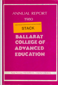
Book, Ballarat College of Advanced Education Annual Report, 1980
... Road. Following the creation by Act of Parliament in 1978.... Following the creation by Act of Parliament in 1978 of the Victorian ...In 1980 M.B.John was Council President. In 1980 the School of Arts moved into their new building, 1870 Founders Hall was financed - at a cost of $800,000 - from the proceeds of the SMB Centenary Appeal, and was completed late in 1980. Extensive work was carried out on the Student Residences and the former Education Department Hostel in Victorian Street. The amphitheatre adjacent to the eastern side of the Education Buildings was constructed, together with the nearby disabled ramp. Negotiations with the Shire of Buninyong were continued for access to the campus from the Green Hill Road. Following the creation by Act of Parliament in 1978 of the Victorian Post-Secondary Education Commission (VPSEC) amendments to the same Act early in 1980 made provision for the repeal of the VIC and SCV Acts. From mid-December 1980 these latter two bodies ceased to exist when the provisions for repeal of their Acts were proclaimed. The Victorian Institute of Colleges had been set up in 1965 to aid in the co-ordination and development of a number of non-university tertiary institutions that affiliated with it from 1965 on to become Colleges of Advanced Education. In taking up this role which had been spelt out in 1964 by the martin Committee, the VIC broke new ground in a whole range of operations. It became responsible for the physical development of new building programmes and new campuses from many of its colleges, for the procurement of operating funds from the Commonwealth, for the accreditation of new courses of study, for the first non-university degrees to be awarded in Australia and so on. The Former Ballarat Institute of Advanced Education (the tertiary division of the School of Mines) was affiliated with the VIC from the outset and its progress towards a new status, rapid growth and vastly improved physical resources was closely linked to and dependent upon the efforts of the VIC. The similar co-ordinating authority - The State College of Victoria - was established in 1973 to similarly foster the autonomous development of the former teachers colleges. its early work was highly influential in the transition of the Ballarat Teachers' College into the State College of Victoria at Ballarat. On the merging of the BIAE and the SCVB in 1976, the new college continued under the co-ordination of the Victorian Institute of Colleges. The major contribution made to the progress and stature of became the Ballarat College of advanced Education by both the VIC and SCV, and their Councils and officers, over the formative years of rapid change and evolution is acknowledged and recorded with appreciation. Such efforts by the two central authorities have markedly assisted in bringing the College to the present point where its accumulated experiences and traditions provide a sound basis on which it can confidently and responsibly exercise the greater autonomy gradually passing it. Purple soft covered book of 47 pages. Contents include: development of a Nurse education course, College organisational Structure, Role of Head of School, resignation of Norman Baggaley, appointment of R. Macgowan, opening of Business Resource Centre, Librarianship, resignation of M.J. Sandow-Quirk, E.A. Widdop, J. Leeuwenburg, Thelma Rungkat, Erica Myers, former Acting Head of School John Mildren elected to the Federal seat of Ballarat, Ray Watson, Resignation of A.C. Burrow, return of W.J. Vermeend, P.L. McCarthy, P.R. Calder, J.A. Fulcher, L.E. Taylor, L.J. McGrath, Teaching Resource Centreballarat college of advanced education, bcae, mt helen, mount helen, sandow-quirk, widdop, leeuwenburg, rungkat, myers, burrow, vermeend, mccarthy, calder, fulcher, taylor, victoria street -
 Flagstaff Hill Maritime Museum and Village
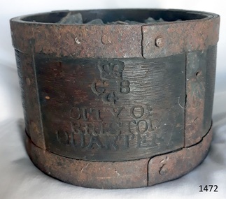
Functional object - Dry Measurement Container, Late 18th to early 19th century (before the standardised measurement was introduced in England in 1824)
... , precious metals, and jewels. In 1963 an act of parliament abolished..., precious metals, and jewels. In 1963 an act of parliament abolished ...The peck has been in use since the early 14th century when it was introduced as a measure for flour. The term referred to varying quantities until the modern units of measurement were defined in the 19th century. Cities in England used to have official standard weights and measures for that city or area. These containers were marked with the city's name and emblem, merchant’s weights and measures would then be checked against this to make sure they weren't trying to cheat their customers. The item in the collection is a standard measure approved by Bristol City and used by that City’s grocers to measure dry goods such as peas, beans, sugar, flour, meal etc., and its metal banding ensures that the measure cannot be reduced in size to cheat customers. Additional Information: The British Imperial System evolved from the thousands of Roman, Celtic, Anglo-Saxon, and customary local units employed in the middle Ages. Traditional names such as pound, foot, and gallon were widely used, but the values so designated varied with time, place, trade, product specifications, and dozens of other requirements. Early royal standards were established to enforce uniformity took the name Winchester, after the ancient tenth century capital of Britain. King Henry VII reaffirmed the customary Winchester standards for capacity and length and distributed royal standards throughout the realm. This process was repeated about a century later in the reign of Queen Elizabeth I. In the 16th century, the rod (5.5 yards, or 16.5 feet) was defined (once again as a learning device and not as a standard) defined by the length of the left feet of 16 men lined up heel to toe as they emerged from the church. By the 17th century usage and legal statute had established the acre, rod, and furlong at their present values together with other historic units such as the peck. Establishment of the System: The Weights and Measures Act of 1824 and the Act of 1878 established the British Imperial System based on precise definitions of selected existing units. The 1824 act sanctioned a single imperial gallon to replace the wine, ale, and corn (wheat) gallons that were in general use. The new gallon was defined as equal in volume to 10 pounds avoirdupois of distilled water weighed at 62°F with the barometer at 30 inches, or 277.274 cubic inches (later corrected to 277.421 cubic inches). The two new basic standard units were the imperial standard yard and the troy pound, which was later restricted to weighing drugs, precious metals, and jewels. In 1963 an act of parliament abolished archaic measures as the rod and chaldron and a metric system was adopted. An early example of a dry measuring container giving a snapshot of how imperial weights and measures developed in England to evolve the British measurement system into the metric arrangement that most countries have adopted today including Australia. It has social significance as an item that was in everyday use by grocers and other merchants to measure dry goods in the late 18th to early 19th centuries and used specifically in the Bristol region of England as an officially recognised measurement.Wooden measurement container with iron banding and hand made rivets container is a Quarter Peck official measurement container. Inscriptions are impressed into the sides of the wooden body. The container has the official crown and emblem of the City of Bristol, indicating this item was the Bristol City standard quarter peck measurement.Impressed into the timber on the front, a crown emblem over "C B G / CITY OF BRISTOL / QUARTER", on one side "HALF" , another side "PECK". Handwritten in white chalk on the base is "1458"flagstaff hill, warrnambool, shipwrecked-coast, flagstaff-hill-maritime-museum, flagstaff-hill-maritime-village, weights and measures, quarter peck, measurement container, dry grocery measure, bristol city measurement standard, city of bristol, british weights and measures, 18th and 19th centure standard measures -
 Orbost & District Historical Society
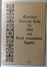
book, E-Gee Printers, Gippsland Electoral Rolls for 1856 and Stock Assessment Payable, 1985
... The Electoral Act 1856 was passed through Parliament o... gippsland The Electoral Act 1856 was passed through Parliament o ...The Electoral Act 1856 was passed through Parliament o March 13, 1856. Victoria was the first Australian colony, and the first legislature anywhere in the world, to adopt the practice of the secret ballot. Victoria's constitution prescribed that the Parliament was to be bicameral, consisting of an upper house, the Legislative Council and a lower house, Legislative Assembly. Men were entitled to vote according to the qualifications described in this book - the right to vote in each house was dependent on status - educational qualifications, income and for either literacy. Two names are registered for the Orbost district: James Dickson and J.C. McLeod.This item is a useful research tool.A 16 pp paper back book which has a clear plastic cover. The covers are beige coloured with the title "Gippsland Electoral Rolls for 1856 and Stock Assessment Payable" in blak print. On the left hand side is a vertical pattern in black print. The book contains an alphabetical list of persons claiming or supposed to be entitled to Vote in the Election of a Member for the District. It lists the needed qualifications of electors followed by the Voters Roll for Legislative Assembly, 1856 and the Voters Roll for Legislative Council, 1856 . It then lists the Stock Assessments, 1856.voting-registers-victoria -
 Flagstaff Hill Maritime Museum and Village
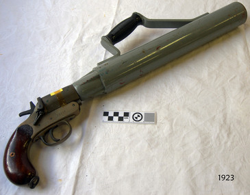
Equipment - Line throwing pistol, 1925-1945
... . The system was approved by the British Navy in 1929 through an Act... Navy in 1929 through an Act of Parliament, which made ...This is a SPRA, or Schermuly’s Pistol Rocket Apparatus. The large firearm type pistol would have been used to throw a line between ships, usually in the event of saving lives. The line throwing pistol consists of a long barrel with handle attached, a pistol grip and trigger, which fires a short blank cartridge. Accessories for the pistol included: flares, 12 gauge adaptor (to shoot 12 gauge flares), a wood plunger, and boxes of faked line. The stamp on the handle, Crown over "NP" is a Birmingham Proof House mark that dates the pistol between 1904 and 1954. However Schermuly's line throwing pistol was invented in the 192s and used on British Naval Ships from 1929. The serial number '22507' is only 806 numbers later than one on sale as a British Military WWII issue SRPA '21701'. This pistol appears to be made 125-1945. The apparatus was used as a life saving device for crew and passengers on vessels in distress that were only a few hundred metres from shore, often eliminating the need to launch a boat and risk lives to go out to the vessel in dangerous conditions. It could also be used from ship to ship rescue. The pistol would launch a line from shore to the vessel. The line would be attached to the vessel, then shore crew would send out equipment, including a breeches buoy, in which the stranded people could be pulled to shore. It has saved many lives at sea. The cartridge is loaded into the breech of the pistol and the rocket is inserted into the muzzle. On pulling the trigger, the gases generated by the fired cartridge eject the rocket on its correct line of flight, and at the same time, burst through the waterproof disc and ignite the propellant mixture, which carries the rocket and line on the remainder of the flight. The rocket consists of a weldless steel case filled with propellant mixture sealed in by a waterproof disc. Fixed to the rocket case is a direction bridle, to the end of which a short length of flexible steel wire is attached, this in turn being connected to the end of the line to be thrown. A complete rocket set, or line throwing kit. would include a wood carrying case, two coils of faked line in separate compartments, three rockets and a can of six cartridges. William Schermuly (1857 – 1929) - Founder of the Schermuly business. In 1897 he invented a trough-fired, line throwing apparatus. In 1920 he and his third son, Alfred James Schermuly, invented the pistol rocket apparatus and promoted this overseas during the 1920s. The system was approved by the British Navy in 1929 through an Act of Parliament, which made it compulsory for ships over 500 tons to carry this equipment. The company, Schermuly Pistol Rocket Apparatus Ltd., grew quickly during and after World War II but business eased off during the 1970s before it eventually closed in the 1990s. Saving lives in Warrnambool – The coastline of South West Victoria is the site of over 600 shipwrecks and many lost lives; even in Warrnambool’s Lady Bay there were around 16 known shipwrecks between 1850 and 1905, with eight lives lost. Victoria’s Government responded to the need for lifesaving equipment and, in 1858, the provision of rocket and mortar apparatus was approved for the lifeboat stations. In 1859 the first Government-built lifeboat arrived at Warrnambool Harbour and a shed was soon built for it on the Tramway Jetty, followed by a rocket house in 1864 to safely store the rocket rescue equipment. In 1878 the buildings were moved to the Breakwater (constructed from 1874-1890), and in 1910 the new Lifeboat Warrnambool arrived with its ‘self-righting’ design. For almost a hundred years the lifesaving and rescue crews, mostly local volunteers, trained regularly to rehearse and maintain their rescue skills. They were summoned when needed by alarms, gunshots, ringing bells and foghorns. In July 1873 a brass bell was erected at Flagstaff Hill specifically to call the rescue crew upon news of a shipwreck. Some crew members became local heroes but all served an important role. Rocket apparatus was used as recently as the 1950s. This line-throwing pistol is part of he Rocket Launching Equipment used to perform life-saving rescue at sea from the 1920s. It is significant for its connection with local history, maritime history and marine technology. Lifesaving has been an important part of the services performed from Warrnambool's very early days, supported by State and Local Government, and based on the methods and experience of Great Britain. Hundreds of shipwrecks along the coast are evidence of the rough weather and rugged coastline. Ordinary citizens, the Harbour employees, and the volunteer boat and rescue crew, saved lives in adverse circumstances. Some were recognised as heroes, others went unrecognised. In Lady Bay, Warrnambool, there were around 16 known shipwrecks between 1850 and 1905. Many lives were saved but tragically, eight lives were lost.Pistol, line-throwing, SPRA (Schermuly's Pistol Rocket Apparatus). This line throwing pistol has a wooden pistol grip, brass trigger mechanism, and a long, wide, steel barrel with Bakelite handle attached to the top. Inscriptions are stamped onto the pistol.Stamped on handle: "5" and "[symbol of a Crown] above NP" , "22507", "[within oval] SPRA" Stamped on barrel: "L22507".gun, pistol, flagstaff hill, warrnambool, shipwrecked coast, flagstaff hill maritime museum, maritime museum, flagstaff hill maritime village, great ocean road, line throwing, line throwing pistol, spra, schermuly's pistol rocket apparatus, sea rescue, pyrotechnicks, marine technology, schermuly pistol rocket apparatus ltd., william schermuly, alfred schermuly, pistol line thrower, flagstaff hill maritime museum and village, maritime village, lady bay, warrnambool harbour, port of warrnambool, shipwreck, life-saving, lifesaving, rescue crew, rescue, rocket rescue, rocket crew, beach rescue, line rescue, rescue equipment, rocket firing equipment, rocket rescue equipment, maritime accidents, shipwreck victim, rocket equipment, rescue boat, lifeboat, volunteer lifesavers, volunteer crew, life saving rescue crew, lifesaving rescue crew, rocket apparatus, rocket rescue method, shore to ship, rocket apparatus rescue, stranded vessel, line throwing mortar, rocket rescue apparatus, line thrower, lifeboat warrnambool, rocket machine, rocket head, rocket launcher, rocket line, beach rescue set, rocket set, schermuly, line-firing pistol, line throwing gun, pistol rocket apparatus, line throwing cartridge, line-throwing rocket, firearm, life saving, lsrc -
 Ballarat and District Irish Association
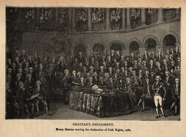
Image, Gratton's Parliament, 1782
... decision, and on 22 January 1783 the final Act was passed... decision, and on 22 January 1783 the final Act was passed ...Calls for the legislative independence of Ireland at the Irish Volunteer Convention at Dungannon greatly influenced the decision of the government in 1782 to make concessions. It was through ranks of Volunteers drawn up outside the parliament house in Dublin that Grattan passed on 16 April 1782, amidst unparalleled popular enthusiasm, to move a declaration of the independence of the Irish parliament. "I found Ireland on her knees," Grattan exclaimed, "I watched over her with a paternal solicitude; I have traced her progress from injuries to arms, and from arms to liberty. Spirit of Swift, spirit of Molyneux, your genius has prevailed! Ireland is now a nation!" After a month of negotiation the claims of Ireland were conceded. The gratitude of his countrymen to Grattan was shown by a parliamentary grant of £100,000, which had to be reduced by half before he would accept it. Grattan then asked for the British House of Commons to reconfirm the London government's decision, and on 22 January 1783 the final Act was passed by parliament in London, including the text: Be it enacted that the right claimed by the people of Ireland to be bound only by laws enacted by his Majesty and the Parliament of that kingdom, in all cases whatever shall be, and is hereby declared to be established and ascertained for ever, and shall at no time be questioned or questionable. In September of the same year, Grattan became a member of the Privy Council of Ireland. He was expelled in 1798, but was re-admitted on 9 August 1806. [http://en.wikipedia.org/wiki/Henry_Grattan, accessed 14/12/2014]An image of a number of men in Parliament. It is Henry Gratton's Parliament. The man standing is Henry Gratton moving the declaration of Irish Rights in 1782.ballarat irish, henry grattan, grattan, irish rights -
 Flagstaff Hill Maritime Museum and Village
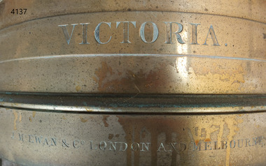
Equipment - Standard measure, Mid to late 19th Century
... June 1824, an Act of Parliament was passed making a universal... June 1824, an Act of Parliament was passed making a universal ...The beginning of standardised weights and measures began In Victoria when the Melbourne Observatory received sets of standard weights and measures, which had been tested in Britain against the then British Imperial standards. These included the primary standard yard and pound for the Colony of Victoria. Other standards of weights and measure held by shires and the administrative body's within the colony could then be compared to these primary standards. A Weights and Measures Act was passed in Victoria in 1862, establishing local inspectors throughout the colony. By the 1870s each local council and shire in Victoria held a set of standards that were used to test scales, weights and dry measures used by wholesalers, factories and shops. Every ten years the councils’ standards would themselves need to be rechecked against the Victorian Standards. The checking was done by the Victorian Customs Department in the 19th century, but with the transfer of responsibility for customs to the Federal Government in 1901, weights and measures function was retained by the Victorian Government and was shifted to the Melbourne Observatory. In 1904, a new building was erected at the south end of the Great Melbourne Telescope House, where the standard weights and measures and testing equipment was installed. This room had a large whirling apparatus for testing air meters and became known as the Whirling Room. When the Melbourne Observatory closed in 1944, the Weights and Measures Branch was formed to continue and this branch remained at the Observatory site unit until 1995. J & M Ewan History: J&M Ewan was a Melbourne firm that began by selling retail furniture and wholesale ironmongery. They had substantial warehouses situated at the intersection of 81-83 Elizabeth and Little Collins Streets, the business was established by James M Ewan in 1852. Shortly afterwards he went into partnership with William Kerr Thomson and Samuel Renwick. When Ewan died in 1868 his partners carried on and expanded the business under his name J & M Ewan. The business was expanded to provide a retail shop, counting-house and private offices. Wholesale warehouses adjoined these premises at 4, 6 and 10 Little Collins Street, West. This company provided and sold a large and varied amount of imported goods into the colony that consisted of agriculture equipment, building materials, mining items as well as steam engines, tools of all types and marble fireplaces. They also supplied the Bronze measuring containers in the Flagstaff Hill collection and the probability is that these containers were obtained by the local Melbourne authority that monitored weights and measures in the mid to late 19th century. The company grew to employ over 150 people in Melbourne and opened offices at 27 Lombard St London as well as in New Zealand and Fiji. The company also serviced the Mauritius islands and the pacific area with their steamship the Suva and a brig the Shannon, the company ceased trading in 1993. Robert Bate History: Robert Brettell Bate (1782-1847) was born in Stourbridge, England, one of four sons of Overs Bate, a mercer (a dealer in textile fabrics, especially silks, velvet's, and other fine materials)and banker. Bate moved to London, and in 1813 was noticed for his scientific instrument making ability through the authority of the “Clockmakers Company”. Sometime in the year 1813 it was discovered that one Robert Brettell Bate, regarded as a foreigner in London had opened a premises in the Poultry selling area of London. He was a Mathematical Instrument maker selling sundials and other various instruments of the clock making. In 1824, Bate, in preparation for his work on standards and weights, leased larger premises at 20 and 21 Poultry, London, at a rental of four hundred pounds per annum. It was there that Bate produced quality metrological instruments, which afforded him the recognition as one of one of the finest and principal English metrological instrument-makers of the nineteenth century. English standards at this time were generally in a muddle, with local standards varying from shire to shire. On 17 June 1824, an Act of Parliament was passed making a universal range of weights, measures, and lengths for the United Kingdom, and Bate was given the job of crafting many of the metrological artifacts. He was under instruction from the renown physicist Henry Kater F.R.S. (1777-1835) to make standards and to have them deposited in the principal cities throughout the United Kingdom and colonies. Bate experimented with tin-copper alloys to find the best combination for these items and by October 1824, he had provided Kater with prototypes to test troy and avoirdupois pounds, and samples with which to divide the troy into grams. Bate also cast the standard for the bushel, and by February 1825, had provided all the standards required of him by the Exchequer, Guildhalls of Edinburgh, and Dublin. In 1824, he also made a troy pound standard weight for the United States, which was certified for its accuracy by Kater and deposited with the US Mint in 1827. Kater, in his address to the Royal Society of London, acknowledged Bate's outstanding experimentation and craftsmanship in producing standards of weights, measures, and lengths. An example of a dry Bronze measuring container made specifically for J & M Ewan by possibly the most important makers of measurement artefacts that gives us today a snapshot of how imperial weights and measures were used and how a standard of measurement for merchants was developed in the Australian colonies based on the Imperial British measurement system. The container has social significance as an item retailed by J & M Ewan and used in Victoria by the authorities who were given legal responsibility to ensure that wholesalers and retailers of dry goods sold in Victoria were correct. The container was a legal standard measure so was also used to test merchants containers to ensure that their distribution of dry goods to a customer was correct.Maker Possibly Robert Brettell Blake or De Grave, Short & Co Ltd both of LondonContainer bronze round shape for measuring dry quantities has brass handles & is a 'half-bushel' measurement"IMPERIAL STANDARD HALF BUSHEL" engraved around the top of the container. VICTORIA engraved under "J & M Ewan & Co London and Melbourne" engraved around the bottom of the container.flagstaff hill, warrnambool, shipwrecked-coast, flagstaff-hill, flagstaff-hill-maritime-museum, maritime-museum, shipwreck-coast, flagstaff-hill-maritime-village, standard measure, bronze, peck measurement, j & m ewan, victorian standard dry measurement, bronze container, victorian standards, melbourne observatory, robert brettell bate -
 Flagstaff Hill Maritime Museum and Village
Equipment - Standard measure, Mid to late 19th Century
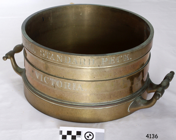
... from shire to shire. On 17 June 1824, an Act of Parliament... from shire to shire. On 17 June 1824, an Act of Parliament ...The beginning of standardised weights and measures began In Victoria when the Melbourne Observatory received sets of standard weights and measures, which had been tested in Britain against the then British Imperial standards. These included the primary standard yard and pound for the Colony of Victoria. Other standards of weights and measure held by shires and the administrative body's within the colony could then be compared to these primary standards. A Weights and Measures Act was passed in Victoria in 1862, establishing local inspectors throughout the colony. By the 1870s each local council and shire in Victoria held a set of standards that were used to test scales, weights and dry measures used by wholesalers, factories and shops. Every ten years the councils’ standards would themselves need to be rechecked against the Victorian Standards. The checking was done by the Victorian Customs Department in the 19th century, but with the transfer of responsibility for customs to the Federal Government in 1901, weights and measures function was retained by the Victorian Government and was shifted to the Melbourne Observatory. In 1904, a new building was erected at the south end of the Great Melbourne Telescope House, where the standard weights and measures and testing equipment was installed. This room had a large whirling apparatus for testing air meters and became known as the Whirling Room. When the Melbourne Observatory closed in 1944, the Weights and Measures Branch was formed to continue and this branch remained at the Observatory site unit until 1995. J & M Ewan History: J&M Ewan was a Melbourne firm that began by selling retail furniture and wholesale ironmongery. They had substantial warehouses situated at the intersection of 81-83 Elizabeth and Little Collins Streets, the business was established by James M Ewan in 1852. Shortly afterwards he went into partnership with William Kerr Thomson and Samuel Renwick. When Ewan died in 1868 his partners carried on and expanded the business under his name J & M Ewan. The business was expanded to provide a retail shop, counting-house and private offices. Wholesale warehouses adjoined these premises at 4, 6 and 10 Little Collins Street, West. This company provided and sold a large and varied amount of imported goods into the colony that consisted of agriculture equipment, building materials, mining items as well as steam engines, tools of all types and marble fireplaces. They also supplied the Bronze measuring containers in the Flagstaff Hill collection and the probability is that these containers were obtained by the local Melbourne authority that monitored weights and measures in the mid to late 19th century. The company grew to employ over 150 people in Melbourne and opened offices at 27 Lombard St London as well as in New Zealand and Fiji. The company also serviced the Mauritius islands and the pacific area with their steamship the Suva and a brig the Shannon. Robert Bate History: Robert Brettell Bate (1782-1847) was born in Stourbridge, England, one of four sons of Overs Bate, a mercer (a dealer in textile fabrics, especially silks, velvet's, and other fine materials)and banker. Bate moved to London, and in 1813 was noticed for his scientific instrument making ability through the authority of the “Clockmakers Company”. Sometime in the year 1813 it was discovered that one Robert Brettell Bate, regarded as a foreigner in London had opened a premises in the Poultry selling area of London. He was a Mathematical Instrument maker selling sundials and other various instruments of the clock making. In 1824, Bate, in preparation for his work on standards and weights, leased larger premises at 20 and 21 Poultry, London, at a rental of four hundred pounds per annum. It was there that Bate produced quality metrological instruments, which afforded him the recognition as one of one of the finest and principal English metrological instrument-makers of the nineteenth century. English standards at this time were generally in a muddle, with local standards varying from shire to shire. On 17 June 1824, an Act of Parliament was passed making a universal range of weights, measures, and lengths for the United Kingdom, and Bate was given the job of crafting many of the metrological artifacts. He was under instruction from the renown physicist Henry Kater F.R.S. (1777-1835) to make standards and to have them deposited in the principal cities throughout the United Kingdom and colonies. Bate experimented with tin-copper alloys to find the best combination for these items and by October 1824, he had provided Kater with prototypes to test troy and avoirdupois pounds, and samples with which to divide the troy into grams. Bate also cast the standard for the bushel, and by February 1825, had provided all the standards required of him by the Exchequer, Guildhalls of Edinburgh, and Dublin. In 1824, he also made a troy pound standard weight for the United States, which was certified for its accuracy by Kater and deposited with the US Mint in 1827. Kater, in his address to the Royal Society of London, acknowledged Bate's outstanding experimentation and craftsmanship in producing standards of weights, measures, and lengths. An example of a dry Bronze measuring container made specifically for J & M Ewan by possibly the most important makers of measurement artifacts that gives us today a snapshot of how imperial weights and measures were used and how a standard of measurement for merchants was developed in the Australian colonies based on the Imperial British measurement system. The container has social significance as an item retailed by J & M Ewan and used in Victoria by the authorities who were given legal responsibility to ensure that wholesalers and retailers of dry goods sold in Victoria were correct. The container was a legal standard measure so was also used to test merchants containers to ensure that their distribution of dry goods to a customer was correct. Bronze round container with brass two handles used as a legal standard for measuring dry quantities & is a 'peck' measurement. "IMPERIAL STANDARD PECK" engraved around top of container with " VICTORIA" engraved under.flagstaff hill, warrnambool, shipwrecked-coast, flagstaff-hill, flagstaff-hill-maritime-museum, maritime-museum, shipwreck-coast, flagstaff-hill-maritime-village, standard measure, bronze, peck measurement, j & m ewan, victorian standard dry measurement, bronze container, victorian standards, melbourne observatory, robert bettell bate -
 Flagstaff Hill Maritime Museum and Village
Equipment - Standard measure, Mid to Late 19th Century
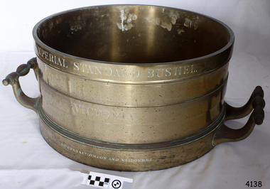
... from shire to shire. On 17 June 1824, an Act of Parliament... from shire to shire. On 17 June 1824, an Act of Parliament ...The beginning of standardised weights and measures began In Victoria when the Melbourne Observatory received sets of standard weights and measures, which had been tested in Britain against the then British Imperial standards. These included the primary standard yard and pound for the Colony of Victoria. Other standards of weights and measure held by shires and the administrative body's within the colony could then be compared to these primary standards. A Weights and Measures Act was passed in Victoria in 1862, establishing local inspectors throughout the colony. By the 1870s each local council and shire in Victoria held a set of standards that were used to test scales, weights and dry measures used by wholesalers, factories and shops. Every ten years the councils’ standards would themselves need to be rechecked against the Victorian Standards. The checking was done by the Victorian Customs Department in the 19th century, but with the transfer of responsibility for customs to the Federal Government in 1901, weights and measures function was retained by the Victorian Government and was shifted to the Melbourne Observatory. In 1904, a new building was erected at the south end of the Great Melbourne Telescope House, where the standard weights and measures and testing equipment was installed. This room had a large whirling apparatus for testing air meters and became known as the Whirling Room. When the Melbourne Observatory closed in 1944, the Weights and Measures Branch was formed to continue and this branch remained at the Observatory site unit until 1995. J & M Ewan History: J&M Ewan was a Melbourne firm that began by selling retail furniture and wholesale ironmongery. They had substantial warehouses situated at the intersection of 81-83 Elizabeth and Little Collins Streets, the business was established by James M Ewan in 1852. Shortly afterwards he went into partnership with William Kerr Thomson and Samuel Renwick. When Ewan died in 1868 his partners carried on and expanded the business under his name J & M Ewan. The business was expanded to provide a retail shop, counting-house and private offices. Wholesale warehouses adjoined these premises at 4, 6 and 10 Little Collins Street, West. This company provided and sold a large and varied amount of imported goods into the colony that consisted of agriculture equipment, building materials, mining items as well as steam engines, tools of all types and marble fireplaces. They also supplied the Bronze measuring containers in the Flagstaff Hill collection and the probability is that these containers were obtained by the local Melbourne authority that monitored weights and measures in the mid to late 19th century. The company grew to employ over 150 people in Melbourne and opened offices at 27 Lombard St London as well as in New Zealand and Fiji. The company also serviced the Mauritius islands and the pacific area with their steamship the Suva and a brig the Shannon. Robert Bate History: Robert Brettell Bate (1782-1847) was born in Stourbridge, England, one of four sons of Overs Bate, a mercer (a dealer in textile fabrics, especially silks, velvet's, and other fine materials)and banker. Bate moved to London, and in 1813 was noticed for his scientific instrument making ability through the authority of the “Clockmakers Company”. Sometime in the year 1813 it was discovered that one Robert Brettell Bate, regarded as a foreigner in London had opened a premises in the Poultry selling area of London. He was a Mathematical Instrument maker selling sundials and other various instruments of the clock making. In 1824, Bate, in preparation for his work on standards and weights, leased larger premises at 20 and 21 Poultry, London, at a rental of four hundred pounds per annum. It was there that Bate produced quality metrological instruments, which afforded him the recognition as one of one of the finest and principal English metrological instrument-makers of the nineteenth century. English standards at this time were generally in a muddle, with local standards varying from shire to shire. On 17 June 1824, an Act of Parliament was passed making a universal range of weights, measures, and lengths for the United Kingdom, and Bate was given the job of crafting many of the metrological artifacts. He was under instruction from the renown physicist Henry Kater F.R.S. (1777-1835) to make standards and to have them deposited in the principal cities throughout the United Kingdom and colonies. Bate experimented with tin-copper alloys to find the best combination for these items and by October 1824, he had provided Kater with prototypes to test troy and avoirdupois pounds, and samples with which to divide the troy into grams. Bate also cast the standard for the bushel, and by February 1825, had provided all the standards required of him by the Exchequer, Guildhalls of Edinburgh, and Dublin. In 1824, he also made a troy pound standard weight for the United States, which was certified for its accuracy by Kater and deposited with the US Mint in 1827. Kater, in his address to the Royal Society of London, acknowledged Bate's outstanding experimentation and craftsmanship in producing standards of weights, measures, and lengths. An example of a dry Bronze measuring container made specifically for J & M Ewan by possibly the most important makers of measurement artefacts that gives us today a snapshot of how imperial weights and measures were used and how a standard of measurement for merchants was developed in the Australian colonies based on the Imperial British measurement system. The container has social significance as an item retailed by J & M Ewan and used in Victoria by the authorities who were given legal responsibility to ensure that wholesalers and retailers of dry goods sold in Victoria were correct. The container was a legal standard measure so was also used to test merchants containers to ensure that their distribution of dry goods to a customer was correct.Maker Possibly Robert Brettell Blake or De Grave, Short & Co Ltd both of LondonContainer brass round for measuring quantities- Has brass handles & is a 'Bushel' measurement. 'Imperial Standard Bushel Victoria' engraved around container. Container bronze round shape for measuring dry quantities has brass handles & is a 'Bushel' measurement"IMPERIAL STANDARD BUSHEL" engraved around the top of the container. VICTORIA engraved under "J & M Ewan & Co London and Melbourne" engraved around the bottom of the container.flagstaff hill, warrnambool, shipwrecked-coast, flagstaff-hill, flagstaff-hill-maritime-museum, maritime-museum, shipwreck-coast, flagstaff-hill-maritime-village, standard measure, bushel, bushel measurement, j & m ewan, dry measurement, victorian measurement standard, bronze container, melbourne observatory, robert brettell bate -
 Flagstaff Hill Maritime Museum and Village
Wood Samples, 1891
... to this, the Shakespeare Birthday Committee was established (by a private Act... to this, the Shakespeare Birthday Committee was established (by a private Act ...The timber display case was presented to Mr Richard Standcombe Harris of Warrnambool (1831-1923). He was a councillor (1875-1891) and predominant businessman. Mr C F Loggin had met Mr Harris while on a trip to Stratford upon Avon in the United Kingdom. Upon his return to Warrnambool, Mr Harris donated the item to the Warrnambool Museum and Art Gallery, (established 1886) where Joseph Archibald was Curator: he catalogued the case in 1894. THE LETTERS IN THE CASE The two letters contained within the display case confirm the authenticity of the oak wood sample. The first letter in the case includes the text; "[Stamped Header on banner] High Street, Stratford on Avon [Hand written] Sept. 22nd / 91. Mr. R. S. Harris, Dear Sir, Enclosed you will find [underlined next 3 words] every authentic proof of the Oak from Shakespeare's House (Birth place). I regret very much Sir, that you made a short-day at S. on A. I should have been delighted to have had the honour, & pleasure, of showing you around our Beautiful Country. You did not give [next 3 words underlined] me or yourself a fair chance. But however I hope that we may again some day have more time to go quietly around. With kind regards, and wishing you, Sir, a pleasant voyage, I remain, Dear Sir, Yours very truly, C.F. Loggin. P.S. A paper will be always acceptable to be as how you Jolly Warrnamboolites are desporting yourselves. “ The second letter includes text; “[Printed Letterhead with stamped impression] The Trustees and Guardians of Shakespeare’s Birthplace Incorporated by Act of 54 and 55, Vict. 1891 Secretary and Librarian - Richard Savage Shakespeare’s Birthplace Stratford-upon-Avon [handwritten] 22 Sept 1891 This piece of oak is a portion of what was cut away at at the restoration of Shakespeare’s Birthplace in 1857-58. C. F. Loggins Chemist 3 High Street Richard Savage Sec. – Shakespeare’s Birthplace Mr C F Loggin was connected with the Shakespeare Trust as the person who had originally donated a scion of Shakespeare's mulberry tree to the "Shakespearean Birthday Committee" in 1842. (The scion that was given to the Shakespearean Birthday Committee, from which the Mulberry sample is derived, still grows today in "New Place" garden.) Mr Richard Savage was the Secretary and Liberian of the then renamed “Trustees and Guardians of Shakespeare’s Birthplace when the display case was given to Mr Harris in 1891 by Mr Loggin. WILLIAM SHAKESPEARE Shakespeare was born in 1564 in Stratford-upon-Avon, where he also grew up. He married at 18 years and he and his wife, Anne Hathaway, had three children: They moved to London where he became successful as an actor, writer, and part-owner of a playing company. He later returned to Stratford and purchased his last home, which he called "New Place" in 1602 where he later died in 1616. For the next 150 years, it was known that there existed a black mulberry tree in the garden. At the time there was a fashion for planting mulberry trees. It was the early 17th century after King James had come to the throne, and he imported tens of thousands of saplings in an attempt to get landowners to start a silk industry in England. Unfortunately for posterity, Shakespeare's mulberry was felled around 1756, by the then owner of “New Place" the Reverend Francis Gastrell, who was apparently tired of continual visits by pilgrims asking to see the tree, so he chopped it down. Gastrell had applied for local permission to extend the garden but the application was rejected and his tax was increased. Gastrell retaliated by demolishing the house in 1759, this greatly outraged the local inhabitants. Gastrell was eventually forced to leave town having provoked the wrath of Stratford residents for committing such an act. Today only the garden remains where “New House" used to stand with a scion from the original mulberry tree still growing there. The wood from the felled mulberry tree at “New House" was purchased by an enterprising local clock-maker Thomas Sharp and he spent the next 40 years or so years making souvenirs from the wood. These became early tourist souvenirs and subsequently developed into a profitable sideline for various other makers, including George Cooper and John Marshall. These objects range from relatively small domestic wooden objects, such as snuff boxes and weight scales to large tea caddies and even tables. C. F. Loggin donated a scion or cutting from Shakespeare's mulberry tree to the Shakespeare Birthplace Trust in 1862, he was a chemist who lived and worked in Stratford. There is a note on the frame of the donation that the mulberry sample is from this scion, research shows that from Richard Savage's diary notes that there must have been a lot of wood taken from that scion over the years which was planted in the garden of “New Place” and is still growing there today. The "Trustees and Guardians of Shakespeare’s Birthplace" (1847 -1964) was formed after the house where Shakespeare is believed to have been born fell into disrepair. Subsequently in 1846 after the death of Thomas Court's widow the last owner. Interest in the house was revived when PT Barnum, the American showman, wanted to buy it and ship the house back to America. In response to this, the Shakespeare Birthday Committee was established (by a private Act of Parliament) with the help of such luminaries as Charles Dickens, the Committee of Trustees raised the necessary £3,000 and purchased the house the following year. Once the Committee had acquired the building, restoration work began. Originally the Birthplace formed part of a terrace with later houses built either side. The first stage in its conservation was their destruction. At the time it was thought necessary to avoid the risk of fire spreading to Shakespeare's birthplace. Reconstruction was carried out by the Shakespeare Trust between 1857 and 1864 that restored the outside of the building to its original 16th-century state. It is from this restoration that the donated piece of oak is derived, originally from a beam that was in the house. Communication from The Shakespeare Birthplace Trust, dated April 11th, 2019, confirms that the pieces displayed in this case have good provenance. The wood samples are significant for their association with the history of William Shakespeare. The display case and its content is significant to Warrnambool local history for its association with the establishment in 1886 of the Warrnambool Museum and Art Gallery. However, it should be noted that the letters of authentication that accompany the wood samples are only applicable to the oak sample. None the less, all the pieces have very good provenance, with Richard Savage's certificate of authenticity for the oak, and the mulberry sample with the letter to Mr Harris from Mr CF Loggin having also been the donor of the scion of mulberry in 1862 to the Shakespeare Birthplace Trust. This scion was then established at Shakespeare's garden at "New Home" that had been demolished by Rev Francis Gastrell in 1759. Two wood samples associated with William Shakespeare, presented in a hanging, timber and glass display case with metal trim around the frame. The case also contains two letters and a label printed on a card that refers to the contents, their origins and the donor. A card label with a printed number and a round adhesive label are attached on the back of the case. The left round section of wood is from a donated scion (or shoot) derived from the original mulberry tree planted by William Shakespeare at his last home "New Place", Stratford-upon-Avon. The outer section is light brown coloured while the centre is dark grain. The right wood sample in the case is a section of oak rafter from the house where Shakespeare was born in 1564. The wood is mid brown with a distinct grain. The included letters, each dated 22/9/1891, refer to only the oak sample. - The letter on the left comprises two handwritten pages from Mr CF Loggin to Mr Richard Standcombe Harris. The paper has the printed letterhead address of High Street, Stratford on Avon. - The letter on the right is a handwritten certificate of authenticity signed by Mr CF Loggin and counter signed by Mr Richard Savage, Secretary and Liberian of the Shakespeare Trust. It is on the printed letterhead of The Trustees and Guardians of Shakespeare’s Birthplace Cardboard label inside the glass case “Shakespeare Section of Mulberry Tree, traditionally said to have been planted by Shakespeare in his garden, “New Place,” Stratford-on-Avon. PORTION OF OAK RAFTER from the house in which Shakespeare was born. (Presented by R S Harris 1891.) Printed label on the back of the case “3 2 “ The handwritten adhesive label “0566” flagstaff hill, warrnambool, shipwrecked coast, flagstaff hill maritime museum, maritime museum, shipwreck coast, flagstaff hill maritime village, great ocean road, shakespeare display case, wood samples, oak from shakespeare's birthplace, mulberry from shakespeare's home "new place", stratford-upon-avon, shakespeare's birthplace, the trustees and guardians of shakespeare's birthplace &c., shakespeare trust, shakespeare birthday committee, r.s. harris, brunswick, victoria, richard s harris, brunswick, victoria, c.f. loggins, chemist, 3 high street stratford-on-avon, richard savage, warrnambool museum and art gallery, thomas court, pt barnum, charles dickins, anne hathaway, black mulberry tree, reverend francis gastrell -
 Ballarat Heritage Services
Photograph - Photograph - Colour, Sunnyside Mill Bridge over the Yarrowee, Hill Street, Ballarat, 2016, 17/09/2016
... , by the provisions of an act of Parliament, called upon the Town Council..., by the provisions of an act of Parliament, called upon the Town Council ..."A joint meeting of city and town ratepayers, convened by Messrs Francis Jago and Henry Johns, interested in the formation of a cart bridge in Hill street, over the Yarrowee Creek, was held on Saturday evening, in the Societies Hall, corner of Skipton and South streets, with the view of taking united action in the matter. Mr Morris was voted to the chair, : and about 60 persons were present. The chairman stated that the object of the meeting was that united influence should be brought to bear upon the City and Town Councils, so that a cartbridge should be erected. He said that Mount Pleasant would no doubt be thickly populated in a few years, and the bridge would prove a great boon to the inhabitants of the locality. By means of a cart bridge drays, would be enabled to save on their journeys to and fro between the mount and the batteries, at least a mile and a half each time. He hoped that the councillors for the south ward would assist them in this matter. Mr Jago, as one of the conveners of the meeting, said that united action on the part of both eastern and western ratepayers was requisite, so as to exert a strong pressure upon the City and Town Councils, in order that the work should be carried but. Mr Grainger moved the first resolution as follows;—“ That the construction of a cart bridge over the Yarrowee Creek at Sunnyside, to facilitate communication between the residents of the city and town, is urgently necessary, and that in the interests of both municipalities the two councils be asked to at once jointly carry out the work. In doing so he said that the necessity of a cart-bridge for the residents of Mount Pleasant would be apparent when the number of batteries, tanneries, and also the Woollen Mill, in the district were considered. The place was of growing import ance, and ready communication should at once be established. Another reason was that an immense saving in time would be effected. It was quite a common occurrence to see one, two, or three drays stuck in the bed of the creek which had gone that way to make a short cut. Now, what with the horses floundering about and breaking their harness, it seemed a wonder to him that life had not been destroyed before now, just through the want of a cartbridge. Mr Johns seconded the resolution. Mr Robert Calvert supported the resolution, and said that it was disgraceful action on the part of the representatives of the south ward that the work had not been executed long ago. They should come together like men and demand that the work should be done, and if not done they should not pay rates until it was. (A voice—“But they’ll make us.” Laughter.) The wooden footbridge across the creek was “only a wooden fabric, not fit for a Christian to walk across, and steps should be taken to remedy this also. Mr Blight, a resident of Mount Pleasant, said that, in common with others, he had been opposed to the erection of the bridge two years ago, but his views had since been altered. Cr. Morrison, who was present, said that the fault of the cartbridge not being erected over the Yarrowee at Hill street lay not with the City Council, but with their neighbors, who had always been opposed to its erection there. In 1874 a motion was carried at a meeting of ‘the City Council" by which the sum of £5OO had been voted to carry but the work. As the bridges over the Yarrowee were joint undertakings of the city and town, they had, by the provisions of an act of Parliament, called upon the Town Council to assist them in the erection of the bridge. In consequence, a conference of the two corporate bodies had taken place, when a motion was moved by Cr Howard, the representative of the south ward, and seconded by Cr Turpie, of Ballarat East—“ That the bridge should be erected at Hill street.” The motion was rejected, principally through the eastern representatives, who wanted the bridge lower down. Since then the two councils had often met to consider, the question of bridges over the Yarrowee Creek, but nothing had been done at the meetings, as the Eastern Council wanted the bridge in one place and the City Council in another. He had himself, when first elected to the council, given notice of motion affirming the desirability of a bridge, at the place now fixed upon. The Woollen Company was growing in importance, and a direct, road to its works would greatly advance its interests. For the working, expenses of each ward £400 was annually, appropriated; and this amount would not be sufficient carry out the work. They would have to obtain a special grant of about £900, as Hill street would require a culvert to be erected therein, as now it was virtually an open drain which carried the drainage of the western plateau to the Yarrowee. He advised that strong pressure should be exerted, specially upon the Eastern Council, and then the work might be carried out. He thought that if the foot bridge was repaired, and large stones thrown into the creek, it would do until the bridge could be erected. The chairman then put the resolution, and it was unanimously carried. Mr Hamilton moved the second resolution— “That Messrs Fern, Greenwood, Peirce, and Jago be deputed by the meeting to wait upon the City and Town Councils and present the first resolution; also that petitions in its favor be signed by all ratepayers interested.” Mr Haigh seconded the resolution, which was carried. Votes of thanks to Cr Morrison for his attendance, and to the chairman for presiding, were passed, and the proceedings terminated." (Ballarat Star, 9 August 1881, page 3) "WOOLLEN MILL BRIDGE YARROWEE IMPROVEMENTS Though brief the official ceremony of opening the bridge across the Yarrowee Creek, near the Sunnyside Woollen Mills, was of an interesting character. It took place at noon yesterday in the presence of the Mayors and councillors of the City and Town. Hon. F. Hagel thorn (Minister of Agriculture).Hon Brawn. M.L.C., Lt-Col Morton (Acting City Clerk). Mr J. Gent (Town Clerk of Ballarat East), Mr A. Farrer (City Engineer), Lt. L. Finch (who is about to leave for the Front, and who assisted Messrs A. Farrer and G. Maughan in carrying out the project, Mr W. Hurdsfield (Clerk of Works) and others. An apology was received from Mr J. McClelland, contractor for the work. Mayor Hill expressed pleasure in Introducing Mr Hagelthorn, who had at great personal sacrifice and inconvenience come from Melbourne to perform the opening ceremony of that beautiful bridge, which was of great improvements that had been effected.When Mr Hagelthorn was Minister of Pubic works he visited Ballarat specially to see the condition of the creek, which at that time was in a disgusting state from a sanitary standpoint. After viewing the position, and realising the justice of the claim. Mr Hagelthorn made strong representations to the Government of which the was a member with the result that it voted £17,000 for the work. That action had been the means of turning a plague spot into a thing of beauty. They therefore owed a deep debt of gratitude to Mr Hagelthorn and the Government of which he was a member, and they were particular grateful to Mr Hagelthorn for coming to Ballarat to perform the open ceremony. Mayor Levy said he could bear testimony to the good work Mr Hagelthorn had always done for Ballarat. In him Ballarat and district always had a good friend. He thought Mr Hagelthorn would feel amply gratified at seeing the good work that had been done. It would serve as some reward for the expenditure, on behalf of the residents of Bal larat, of the amount of money made available through Mr Hagelthorn's instrumentality for the two municipalities. Otherwise the City and Town councils would not have been able to carry out so necessary and so beneficial a work. There was a great amount of work yet to be done, and when the financial market became low stringent Mr Hagelthorn would no doubt be pleased to take the necessary steps to have money provided for further works which could not be undertaken at the present time. The adjacent woollen mill was a standing monument to what was being done in Ballarat, and what ever the City and Town Councils or the Government could do to encourage such manufacturing enterprise should be done, and he was glad to be able to say that was being done as far as finances would permit. He concluded by presenting Mr Hagelthorn with a gold mounted pocket-knife with which to cut the ribbon stretched across the centre of the structure as a bar to traffic. The Hon. F. Hagelthorn, who was greeted with applause said before him was a good work well done in the interests of the public. Real prosperity could only be achieved by a movement carried out by the people to increase natural productiveness. Most of them had been made aware, on account of the war par tiularly, that the people who were best equipped, the industries that were best organised, and the Governments that were most intelligently controlled would get the most of this world's goods and some of its luxuries that Would be denied other people less efficient. Any thing the Government could do to promote industry and to increase the reward of those engaged in it, both employer and employee, would be done. Most Governments would do but little in that regard. ... " (Ballarat Courier, 13 September 1916, page 4)Bluestone and iron bridge over the Yarrowee River at Hill Street, Ballarat.sunnyside mill, sunnyside woollen mill, ballarat woollen mill, bridge, yarrowee creek, francis jago, mount pleasant, yarrowee river, robert calvert -
 Flagstaff Hill Maritime Museum and Village
Memorabilia - Horseshoe Case, 1906 – 1907
... of the first act of Australia's new parliament, the Immigration... parliament, the Immigration Restriction Act 1901 (cth) or commonly ...The horseshoes in this purpose-built display case were made by Thomas Alfred Chapman in 1906-1907. Chapman operated a blacksmith’s shop in Mortlake Rd, Purnim, about 15 mins drive from Warrnambool. Chapman made this horseshoe case especially for the 3rd Exhibition of Australian Manufacturers and Products, held in the Exhibition Building in Melbourne, which was organised and promoted by the Australian Natives Association (ANA). Reference is made to the horseshoe case in the Exhibition’s Souvenir Catalogue of 1907 on page 85, under the heading 'In the Machinery Section the following exhibits are also shown … 'CHAPMAN, T.A. , Woolsthorpe, via Warrnambool, Case of Horseshoes'. The Australian Natives’ Association (ANA) were a non-partisan and non-sectarian, friendly society founded in Melbourne, Australia in April 1871. It was set-up for the benefit of Australian-born white men, and membership was restricted exclusively to that group. Men of other races including the Chinese and Indigenous people were not allowed to join. The ANA had relatively progressive views on women (for the time) and attracted suffragists seeking support for their cause, and in 1894, the ANA advocated for women’s enfranchisement. Although, white women were only admitted as members from 1964. The organisation was most prominent in Victoria and sought to shape Australia’s national identity and was a training ground for businessmen, trade unionists and politicians including many of Australia’s early prime ministers such as Edmund Barton, Alfred Deakin, James Scullin and Francis Forde, and the first Australian-born governor-general, Isaac Isaacs, was a member. By 1910 it had developed into a nationwide association with real political and social influence, and members would participate in many activities. The ANA lobbied strongly for anti-Chinese legislation and were an ardent believer of colonial unification. Its mission and efforts are largely credited for the successful referendums that resulted in Federation of the six Australian colonies into a new nation, the association’s most important legacy. The ANA was also a supporter of trade protection, and were a staunch advocate of the first act of Australia's new parliament, the Immigration Restriction Act 1901 (cth) or commonly known as the White Australia Policy, which became one of the central pillars of Australian nationalism in the 20th-century. The ANA campaigned against the Australian Federal Government's new immigration policy after the Second World War (non-British immigration from southern and central Europe) in order to maintain a 'white Australia', and resisted changes when the Labor government during the 1970s fully dismantled and abandoned the White Australia Policy. The ANA merged with Manchester Unity Independent Order of Oddfellows, in 1993 to become Australian Unity Ltd. The display case of horseshoes changed hands several times, going from its maker Thomas Chapman to his mother then various other members of his family. The case was also displayed at the Lee Family’s butcher shop at 188 Liebig St Warrnambool, and in the Purnim Hotel during the Warrnambool May Races. In the late 1950s the horseshoe case went to Thomas’s son, Brian. He was a Master Farrier and completed his apprenticeship at Flemington Racecourse, and in Warrnambool he owned a blacksmith business at the Warrnambool Racecourse Grounds. Brian later operated a blacksmith’s at Flagstaff Hill, where his customers would bring their horses to be shod. Brian passed away in August 2017. The horseshoe case is significant as an example of trades in the early 20th century in Western Victoria, Australia. It is also significant as an example of horseshoes from the early 20th century. The horseshoe display case is also significant for its association with the Australian Exhibition of 1907, showcasing Australian produce and manufacturing to the world. The horseshoe display case is locally significant for its association with local families, essential businesses and community events. Display case of homemade horseshoes. Wooden case with glass front containing 16 horse shoes grouped in sets, each set with a label: Made 1906-1907 for Australian Exhibition of 1907 by Thomas Alfred Chapman of Warrnambool. The case contains (a) complete chrome set each of Trotting Shoes, Hunting Shoes and Racing Plates, and (b) one pair of Hind Polo Shoes and one pair of Front Aluminium Shoes. The wooden frame has gold lettering on each side proclaiming “Australian Natives Association, T.A. Chapman, horse shoer, Warrnambool” and is topped by a painted Australian coat of arms. Gold lettering on frame, in the order of top/bottom/ left/right “AUSTRALIAN.NATIVES.ASSOCIATION / T.A. CHAPMAN / Horse Shoer / Warrnambool”flagstaff hill, warrnambool, shipwrecked coast, maritime museum, shipwreck coast, horseshoe display case 1906-1907, chromed set of trotting shoes 1906-1907, chrome set of hunting shoes 1906-1907, chrome set of racing plates 1906-1907, pair of hind polo shoes 1906-1907, pair of front aluminium shoes 1906-1907, australian exhibition 1907, australian natives association (ana), t.a. chapman horse shoer warrnambool, thomas alfred chapman, brian chapman, brian “snacks” chapman, blacksmith warrnambool, warrnambool may races, warrnambool racecourse, purnim hotel, lee family’s butcher shop warrnambool -
 Ballarat and District Irish Association
Image, Rent Day (as it is under coercion) - No Rent, c1864, c1864
... Protection of Person and Property Act 1881... Protection of Person and Property Act 1881 The ''Protection ...Protection of Person and Property Act 1881 The ''Protection of Person and Property Act 1881'' was one of more than 100 Coercion Acts passed by the Parliament of United Kingdom of Great Britain and Ireland between 1801 and 1922, in an attempt to establish law and order in Ireland. The 1881 Act was passed by parliament and introduced by Gladstone. It allowed for persons to be imprisoned without trial. On 13 October 1881, the Act was used to arrest Charles Parnell after his newspaper, the ''United Ireland'', had attacked the Land Act. On Gladstone's return to office in 1880, William Edward Forster was made Chief Secretary for Ireland. He carried the Compensation for Disturbance Bill through the Commons, only to see it thrown out in the Lords. On 24 January 1881, he introduced a new Coercion Bill in the House of Commons, to deal with the growth of the Irish National Land League. Despite a 41-hour long fillibuster in the House by the Irish Parliamentary Party, the bill passed, among its provisions being one enabling the British government in Ireland to arrest without trial persons "reasonably suspected" of crime and conspiracy. However those arrested were often not always suspect, only supportive of the Irish National Land League's movements. Over 100 such acts were passed, some of the more notable of which were "An Act for the more effectual Suppression of Local Disturbances and Dangerous Associations in Ireland", "The Protection of Life and Property in Certain Parts of Ireland Act", and the "Protection of Person and Property Act 1881". An Irish Coercion Bill was proposed by Sir Robert Peel to calm the increasing difficult situation in Ireland as a result of the Great Famine 1844–47. The Bill was blocked and this led, in part, to Peel's retirement as Prime Minister. Later attempts to introduce Irish coercion acts were blocked by the filibustering of Joseph Biggar. As a response to the Plan of Campaign of the mid-1880s the new Chief Secretary for Ireland Arthur Balfour secured a tough Perpetual Crimes Act (1887) (or Coercion Act) aimed at the prevention of boycotting, intimidation, unlawful assembly and the organisation of conspiracies against the payment of agreed rents. The Act resulted in the imprisonment of hundreds of people including over twenty MPs. The so-called ''Crimes Act'' (or "Coercion" Act) was condemned by the Catholic hierarchy since it was to become a permanent part of the law and did not have to be renewed annually by parliament, but the Papacy issued the bull Link: "Saepe Nos" in 1888 which was uncritical of the Acts. Trial by jury was abolished. An influential analysis of the pros and cons of the Act was published in 1888 by W. H. Hurlbert, a Catholic Irish-American author. Many hundreds were imprisoned at times under the Acts, including many prominent politicians and agrarian agitators, Joseph Biggar, Alexander Blane, Michael Davitt, John Dillon, James Gilhooly, Patrick Guiney, Matthew Harris, John Hayden, J. E. Kenny, Andrew Kettle, Denis Kilbride, Pat O'Brien, William O'Brien, James O'Kelly, Charles Stewart Parnell, Douglas Pyne, Willie Redmond, Timothy Sullivan. [http://shelf3d.com/i/Irish%20Coercion%20Act, accessed 13/12/2013]A many sits on a table holding the lapels of his Jacket. ballarat irish, cabin, rent, tenants, quill, biggar, davitt -
 Orbost & District Historical Society
book, The Bridge, 1930's
This book was written by Dr J. J. C. Bradfield, (John Job Crew), 1867-1943. Dr JJC Bradfield was a visionary Australian engineer who worked with enormous energy and vision to build the infrastructure which he foresaw that Sydney would need as it grew. As early as 1903 Bradfield was making the case for the Sydney Harbour Bridge, in his presidential address as President of the Sydney University Engineering Society. Bradfield’s proposal — at that stage for a cantilever bridge between Dawes Point and Milsons Point — won the committee’s support and they recommended it be accepted. However, the First World War put a stop to these plans. While a bill to authorise the project passed the lower house of the NSW parliament in 1916, it failed to pass the upper house, on the grounds that funds should not be diverted from the war effort. With the war over, in 1922 the Sydney Harbour Bridge Act was passed by the NSW Parliament. The Sydney Harbour Bridge was officially opened in 1932 after Museum and St James railway stations were built. This book was written from the story broadcast by Dr. J.J.C. Bradfield. This item is a useful reference tool.A staple soft cover 16 pp booklet with a buff coloured cover. It has a sketch of the Sydney Harbour Bridge behind the title "The Bridge" in dark brown print. It contains information and photographs of the history and construction of Sydney Harbour Bridge.sydney-harbour-bridge bradfield-dr-j-j-c -
 Lara RSL Sub Branch
Royal Banner of Scotland
... correct use is restricted by an Act of the Parliament of Scotland ...The earliest recorded use of the Lion rampant as a royal emblem in Scotland was by Alexander II in 1222;[5] with the additional embellishment of a double border set with lilies occurring during the reign of Alexander III (1249–1286).[5] This emblem occupied the shield of the royal coat of arms of the ancient Kingdom of Scotland which, together with a royal banner displaying the same, was used by the King of Scots until the Union of the Crowns in 1603, when James VI acceded to the thrones of the Kingdom of England and Kingdom of Ireland.[6] Since 1603, the Lion rampant of Scotland has been incorporated into both the royal arms and royal banners of successive Scottish then British monarchs in order to symbolise Scotland; as can be seen today in the Royal Standard of the United Kingdom.[7] Although now officially restricted to use by representatives of the Sovereign and at royal residences, the Royal Standard of Scotland continues to be one of Scotland's most recognisable symbols.[8] The Royal Standard of Scotland, (Scottish Gaelic: Bratach rìoghail na h-Alba), also known as the Banner of the King of Scots,[1] or more commonly the Lion Rampant of Scotland,[2] is the Scottish Royal Banner of Arms.[3] Used historically by the King of Scots, the Royal Standard of Scotland differs from Scotland's national flag, the Saltire, in that its correct use is restricted by an Act of the Parliament of Scotland to only a few Great Officers of State who officially represent the Sovereign in Scotland.[3] It is also used in an official capacity at royal residences in Scotland when the Sovereign is not present.[4] Rectangular shaped glass covered picture frame with the Royal Banner Of Scotland flag.flags, royal banner of scotland, lion rampant of scotland, lara r.s.l.