Showing 126 items
matching alps
-
 Kiewa Valley Historical Society
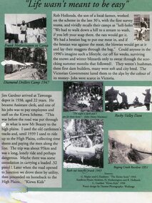
Posters – Set of 3 A4 posters depicting the early days and people in the Kiewa Valley
In the 1830’s, European pastoralists started moving south from NSW into the Alps. In 1836, cattle grazing began around Omeo and the runs spread out into the foothills. The higher country was used for summer grazing and huts were built for shelter and storage during stock mustering. The lure of gold brought many people to the Alps from around 1850 to 1900. Bushfires destroyed the forests around Melbourne in 1939 and the boom in house-building after World War II ked to increased demand for timber from the Alps. This resulted in the building of a network of roads which helped open up access to the Alps. The early 1940’s brought the first of many workers to the Alps for the planning and construction of the Hydro-Electric Scheme. These were the pioneers and early settlers of the Kiewa Valley and provided a wealth of characters and a tapestry of stories and adventures to be handed down to future generations.These 3 posters, which were most likely produced for promotional purposes provide a glimpse into the early lives of the pioneer families of the Kiewa Valley through pictures and verse. They show their lifestyle and outline the hardships they had to endure in living and working in the Alpine region. They also highlight the early arguments regarding grazing in the high country which would ultimately lead to the end of the long traditions of the high country cattle men. Set of 3 A4 size posters with black and white photographs and text and colour background depicting various parts of the history of the Kiewa Valley. 1. Titled - ‘Life wasn’t meant to be easy’ Describes early life for Kiewa Hydro workers. 2. Titled - ‘Cattlemen of the High Plains’ Describes a brief history of life of the cattlemen of the high plains 3. Titled – ‘There are Places I’ll remember’ Depicts early photographs of residents of the Kiewa Valley, also includes the words from a John Lennon song as per poster title. Printed on each poster – Poster designed by Dyanne Photography - Wodonga 1. Printed at bottom of poster – Sources: G Napier and G Easdown “The Kiewa Story” 1993. Southern Hydro Archives, N Hetherington and R Hollands. G Gardner “The Kiewa Kids” 1998. 2. Printed at bottom of poster – Sources: D Purland. Handwritten at top of poster- Poster 4 3. Printed at bottom of poster – Sources: B Roper, W Davies, D Higginson, H Ryder. Handwritten at top of poster- Poster 3 kiewa valley; tourism; lifestyles -
 Kiewa Valley Historical Society
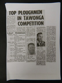
Papers - Collection of newspaper articles re Kiewa Valley, 1970's
Newspaper articles describing incidents/news of the Kiewa Valley during the 1970's.Each article is significant because it is connected to people and places in the Kiewa Valley.9 photocopies of newspaper articles: 1. Fire at Mt Beauty Workmen's club 2. Ploughing Championship at Tawonga 24 Apr. 1971 3 & 4. Charles Derrick's 10 year anniversary of his death on Mt Hotham 5 Sept. 1975 5. Alps to be a National Park 15 July 1978 6. Tawonga Exchange to go Automatic 20 June 1974 7 & 8. Winter Playground 9. Alps National Parknewspaper articles; kiewa valley; news of the 1970s; -
 Federation University Historical Collection
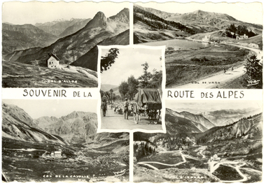
Postcard - black and white, MAR, Le Route Des Alpes, c1920
Black and white photographic postcard showing 5 views including Col D'Allos, Col, de Vars, Col dela la Cayolle and Col D'oeoarochatham-holmes family collection, alps, france -
 Lakes Entrance Historical Society
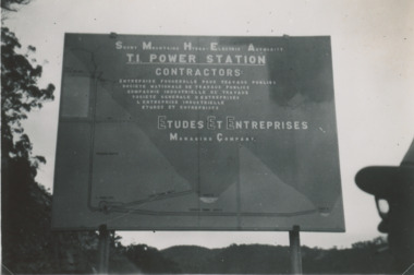
Photograph - Snowy Mountains Hydro Electric Scheme c1950, Jack Palmer, 1950 c
Black and white photograph taken at sign for Snowy Mountains Hydro Electric Scheme in Australian Alps. Also five other black and white photographs taken at Snowy Mountain project 6 x 8.5 cm government, civil engineering, topography, water resources -
 Lakes Entrance Historical Society
Photograph - Snowy Mountains Scheme c1950, Jack Palmer, 1950 c
Black and white photograph of view of village established for workers at Snowy Mountains Scheme Australian Alps Victoria. Also five other black and white photographs taken at same time of housing at village 6 x 8.5 cmcouncil, government -
 Ballarat Heritage Services
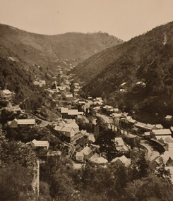
Photograph - Image - Black and White, Walhalla Looking North, c1903, c1903
Walhalla is a historic gold mining town nestled in a scenic valley in the Victorian Alps. It is named for the German hall of fame, the Walhalla temple,Sepia image of the Victorian goldtown Walhalla.walhalla, mining, townscape, gippsland -
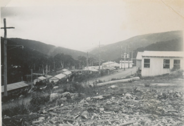
 Kiewa Valley Historical Society
Photograph from Lake Guy, Bogong Village, Scene from shores of Lake Guy to Mountain range, 1930s to 1950s
In 1940 Field Headquarters for the Kiewa Scheme were established at Bogong with office, workshop facilities and accommodation for workmen, staff and some families constructed. (There had been a 'tent camp' on this site in 1939 but was destroyed by bushfires) Construction of accommodation continued until 1947. A total of 40 houses plus a hostel for single staff, post office, police station, medical centre and primary school all with water and sewerage and electricity supply. The staff hostel was known as Kiewa House and is now occupied by the Education Department. Lake Guy was named after Mr. L.T. Guy who was the Resident Engineer in charge of construction work and associated activities on the Kiewa area. He held this position from 1939 to November 1946 when he was transferred to Head Office.The Bogong Township was developed firstly as an accommodation centre (base camp) for construction workers employed under the Kiewa Hydroelectric Scheme. Due to the influx of European workers into the Township the beautification of the immediate surrounds(gardens etc.) had a distinct European flavour. This environment has been very beneficial for tourism in later years. Strict environmental control has not allowed for any extensive redevelopment in tourist accommodation and basically restricted it to the accommodation initially built for the construction workers. Activities such a bike riding, snow skiing, restricted horse riding and bush walking on the Alpine plains and mountains are now a viable part of the Kiewa Valley Tourist Industry. The lake is one of the many water storage storage reservoirs used to supply the power stations their main power to run the huge turbines generating the final product, electricityThis black and white photograph shot from the shores of Lake Guy toward the mountain range of the Victorian Alps details the early construction of the construction worker's accommodation of the Bogong Village. The paper is of 200gms and is not photographic paper and can be assumed to be a reproduction of an original photobogong village circa 1930 to 1950, kiewa hydro-electricity scheme, victorian alpine region mid 1900s -
 Federation University Historical Collection
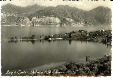
Postcard - black and white, F Micheletti, Lago di Garda - Malcesine - Val di Sogno, c1918
Black and white photographic postcard showing a lake with mountains in the background. The view is in the Northern Italy pre-Alps.This card was purchased by an Australian soldier, probably Henry Smerdon Holmes, during World War One. chatham-holmes family collection, sogno, alps, italy, lombardy -
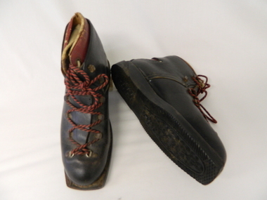 Kiewa Valley Historical Society
Ski Boots - Cross Country, mid 1900's
These cross country ski boots are part of the pioneer ski recreational sport in the Victoria Alps. The mid 1900's saw the Victorian Alps begin to be used for recreational skiing, especially cross country. The majority of skiers at this point in time were either from the SEC Vic. Kiewa Hydro Scheme or from Melbourne. International skiers had better ski fields (ski lodges etc.) in Europe, the U.S.A. and Canada. With greater and better coverage of the Winter Olympics and some medal wins, skiing became more interesting and rewarding for city dwellers in Melbourne and Sydney.These ski boots are of great significance to the Kiewa Valley as it demonstrates that winter sports in the region have and still do attract not only skiers but also provide an employment (even though seasonal) avenue which "livens up" a small rural community and provides for a diversity of land usage which did not exist in the 1800's. These brown cross country ski boots, "Grief" brand have "cherry" inserts with cream laces, within the main boot. The boots have red and black laces and crossover tie flaps (to allow for maximum front foot entry. These boots do not have any ski clips to hold firm those restraints (quick release) on the skis (like "modern boots and skis). The heel section has the red Greif "W" pattern.At the underside of the rubber sole in freehand script "Cresta"snow skiing, ski boots, winter recreational sports. -
 Bendigo Historical Society Inc.
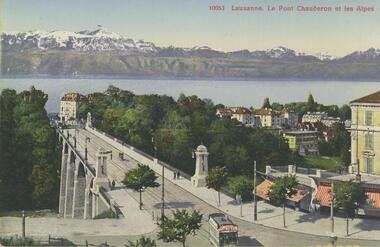
Postcard - ROY AND DORIS KELLY COLLECTION: LAUSANNE. LE PONT CHAUDERON ET LES ALPES, 1900-1920
Postcard, coloured photo of Lausanne showing the Chauderon Bridge over the Flon Valley with the Swiss Alps in the background. Light pedestrian traffic over the bridge with a tram and shops in foreground. Lake Lausanne in the middle distance. Printed on the back 'Edition Art. Perrochet & David, La Chaux-de-Fonfs-Lausanne'postcard, photograph, postcard, lausanne, switzerland, chauderon bridge, swiss alps -
 Slovenian Association Melbourne
Photo Mountaineers Dance - Planinska zabava 1955, Mountaineers Dance - Planinska zabava 1955, 1955
Slovenians are very proud of their mountain Mt Triglav, towering 2864m high in the Alps region of Slovenia. It is their symbol of greatness, might, power and strength. They love to sing songs about Mt Triglav, they used the mountain as the emblem and in many ways culturally.The Aljaž tower was built with card and painted for the occasionBlack and white photo of some participants of the Mountaineers dance in 1955 held at Prahran Town hall. Some people who attended: Mici Hartman, Max Hartman senior, Mima Adamic, Martin Adamic, Marijan Persic, Franc Hartman, Tinka Verbic, Zladko Verbic, Zerdoner Vekoslav, Mrs Potocnik.The photo showcases the Aljaž tover, which stands on top of Mt Triglav, the highest mountain in Slovenia (2984m) and the participants enjoying the eventmt trigla, aljaž tower, slovenian alps, slovenian club melbourne -
 Surrey Hills Historical Society Collection
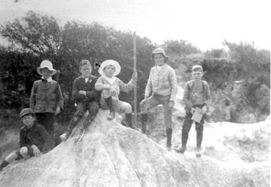
Photograph, Boys who later joined the 1st Surrey Hills scout troop, 1909
1st Surrey Hills was the 3rd troop formed in Victoria. Harrison Buchanan was not old enough to join and for a time was the 'troop mascot' as the cubs had not been formed at this time. He later became the troop's 2nd Scoutmaster. Doug Jeffries lived at 12 Vincent Street. Alex Lucas was the son of the draper in Canterbury Road. Our documentation variously gives the date as 1901 or 1909.Six boys are pictured against a backdrop of scrub in the eroded creek bed, called 'The Alps', of Back Creek opposite Wattle Park. Three of them are identified as: Harrison Buchanan (with the stave), Doug Jeffries on the LHS and Alex Lucas next to him.Black and white photo measuring L 24.5 cm x H 17.4 cmback creek, 1st surrey hills scout troop, scouts, harrison buchanan, alex lucas, doug jeffries, childhood and youth, topography -
 Federation University Historical Collection
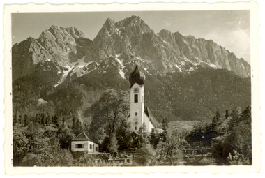
Photograph - Photograph - Black and White, Church at Garmisch-Partenkirchen, Bavaria, Germany
Garmisch (in the west) and Partenkirchen (in the east) were separate German towns for many centuries, and still maintain quite separate identities. Partenkirchen originated as the Roman town of Partanum on the trade route from Venice to Augsburg and is first mentioned in the year A.D. 15. Its main street, Ludwigsstrasse, follows the original Roman road. (Wikipedia)A church stands before large mountains in Garmisch-Partenkirchen, Bavaria, Southern Germanychatham family collection, garmisch-partenkirchen, bavaria, germany, church, alps -
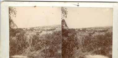 The Beechworth Burke Museum
Photograph - Stereoscopic Photograph
This photograph offers a view of Beechworth, located at the foot of the Victorian Alps. It captures the gorge and native vegetation in the foreground, with the Beechworth township visible in the middle, where the hospital is marked with an arrow. Distant hills form the backdrop. Originally settled c1839, Beechworth was officially proclaimed a town in 1856.This photograph is historically significant as it captures the landscape of Beechworth, providing valuable insight into the town's visual and historical character.Two sepia-toned square photographs showing the view of a town with trees in the foreground and hills in the far distance, mounted.Obervse: Above the right photograph there is an arrow pointing down. Reverse: 97.2195/ View across the Gorge/ looking over Beechworth/ (Hospital under arrow)/ 84-110-1/ A03082beechworth, town, landscape, ovens district, stereoscopic -
 Kiewa Valley Historical Society
Ski Skins - Pair
Ski skins and webbing were introduced into the Victorian Alps by European skiers. Enthusiasts travelled to enjoy the snow and to explore the Victorian Alps including the Bogong High Plains. This equipment enabled them to travel over snow without slipping when going up hills. They took the skins off when they wanted to slide down hills. In later years waxes were used for cross country skiing and then 'fish tail' markings on the back of skis to enable skiers to travel distances up and down mountains. Later developments also included motor transport (replacing horses to get to the snow line) and roads to take skiers to the ski fields and mechanised tows to take skiers up mountains so they could ski down (downhill skiing).Skiers visited the Bogong High Plains especially during the years of the State Electricity Commission of Victoria's construction of the Kiewa Hydro Electric Scheme from the 1930's onwards. Tourists to the area increased during this time and influenced the development of Falls Creek.Long cream strips with soft short 'fur' on one side and a type of strong hessian on the back with the length of the middle and sides stitched. At one end an adjustable strap is attached to a steel, hinged clasp and at the other end is a loop that fits over the ski. A quarter of the way from each end is a steel attachment for fastening over the ski - the 'toe' end with a rubber embossed flap and the other with a short and long strap each with a steel ring at the end.On the rubber attachment: 'vinersa/pat uno'ski skins; bogong high plains; falls creek -
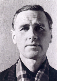 Whitehorse Historical Society Inc.
Photograph, Lionel Jones, c1944
Lionel was captured and became a prisoner of war in Italy. When Italy withdrew from the war they opened the gates of the P.O.W. camps. Lionel and a friend were working for Padroni who helped them with food and civilian clothing. They walked to the Switzerland border and with the help of Partisan who got them to Smugglers gap in the alps and then to Switzerland.Black & white photo of Lionel Jones in civvies after his escape as a P.O.W. See also ND4877 and Historyjones lionel, prisoners of war, world war 1939- 1945 -
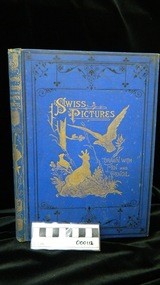 Ballarat Clarendon College
Book, Rev Samuel Manning, Swiss pictures drawn in pen and pencil
Prize awarded to Catherine Proctor for excellence in algebra and geometry in the fourth form. This was Catherine's first year at Ballarat College. During 1877 - 1891 Ballarat College accepted enrolments from female students. The school holds the original register of this period and notes that catherine Proctor entered the school in 1878 when she was 15. She went on to be awarded Dux of the female cohort in 1879. Published by The Religious Tract Society, London. "A New and Enlarged Edition". 210pp. Blue cloth with gilt drawing of "Wild Life in the Alps" framed in black spiral pictorial. Spine in heavy gilt and all page edges in gilt. Many B&W illustrations plus one full-page colour of Whymper's "Mont Blanc from above Morges". Book has the usual age markings.Book plate inside front cover: Ballarat College crest / Algebra and Geometry / Fourth form / First PRIZE / Awarded to / Catherine Proctor / CHRISTMAS 1878 / JOHN GARBUTT M A PRINCIPALcatherine-proctor, ballarat-college, girls-school, john-garbutt, 1878, book-prize -
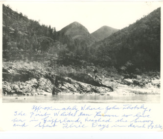 Lakes Entrance Historical Society
Photograph - Snowy River Buchan, 1977 c
Polish scientist explorer Dr. Lhotsky explored the Australian Alps south of Mt Kosciusko (not named at that date)as far as McKillops Bridge (unnamed then) between 1834 and 1839. His claims were largely ignored he being labelled imposter and humbug but recent research indicates his rightful place amongst Victorias early explorersBlack and white photograph of Snowy River at Suggan Buggan VictoriaApproximately where John Lhotsky the first white man known to have been in Gippsland reached the Snowy and spent three days in March 1834topography, rivers -
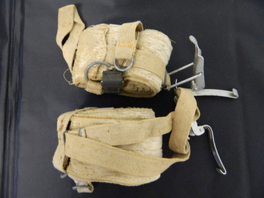
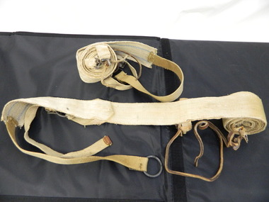 Kiewa Valley Historical Society
Seal Skins Ski Straps / Soles
Seal skin straps and webbing were introduced into the Victorian Alps by European skiers. Enthusiasts travelled to enjoy the snow and to explore the Victorian Alps including the Bogong High Plains. This equipment enabled them to travel over snow without slipping when going up hills. They took the skins off when they wanted to slide down hills. In later years, waxes were used for cross country skiing and then 'fish tail' markings on the back of skis to enable skiers to travel distances up and down mountains. Later developments also included motor transport (replacing horses to get to the snow line) and roads to take skiers to the ski fields and mechanised tows to take skiers up mountains so they could ski down (downhill skiing). Skate skiing has also developed as another form of skiing.Skiers visited the Bogong High Plains during summer and winter to explore and enjoy the High Plains. The equipment used was a forerunner to the variety used today and the different types of skiing done today. Falls Creek was developed during the construction of the Kiewa Electric Hydro Scheme and was influenced by the number of Europeans working on the scheme and their desire to make use of the snow during winter.Each Seal skin has: Seal skin sewn onto one side of a strap of webbing. There is a webbing loop on the front that slips over a small point at the front of the ski. There is a webbing strap attached to the back of the seal skin sole coming over the back of the ski that clips metal fasteners onto a loop of webbing behind the boot.skiing. snow. high plains. seal skins. cross country skiing. alpine sports. -
![View on the Upper Buckland River / [by] Nicholas Caire, circa 1876](/media/collectors/550653872162f11fb04854aa/items/57830fc0d0cdd1176c450fda/item-media/57831013d0cdd1176c454bda/item-fit-380x285.jpg) Kew Historical Society Inc
Kew Historical Society IncPhotograph, Anglo-Australasian Photographic Company, View on the Upper Buckland River, c. 1876
Nicholas Caire was born on Guernsey in the Channel Islands in 1837. He arrived in Adelaide with his parents in about 1860. In 1867, following photographic journeys in Gippsland, he opened a studio in Adelaide. From 1870 to 1876 he lived and worked in Talbot in Central Victoria. In 1876 he purchased T. F. Chuck's studios in the Royal Arcade Melbourne. In 1885, following the introduction of dry plate photography, he began a series of landscape series, which were commercially successful. As a photographer, he travelled extensively through Victoria, photographing places few of his contemporaries had previously seen. He died in 1918. Reference: Jack Cato, 'Caire, Nicholas John (1837–1918)', Australian Dictionary of Biography.An original, rare photograph from the series 'Views of Victoria: General Series' by the photographer, Nicholas Caire (1837-1918). The series of 60 photographs that comprise the series was issued c. 1876 and reinforced a neo-Romantic view of the Australian landscape to which a growing nationalist movement would respond. Nicholas Caire was active as a photographer in Australia from 1858 until his death in 1918. His vision of the Australian bush and pioneer life had a counterpart in the works of Henry Lawson and other nationalist poets, authors and painters.‘View on the upper Buckland River’ : Views of Victoria (General Series) No.46 : Albumen silver photograph | Photo on card with Title and Description on reverse | Mounted 24 x 30 cm; Photo 12 x 17 cm.On Reverse: ‘The Buckland River is situated near the western extremity of the Australian Alps, and forms one of the sources of the Ovens River. Its watercourse is very shallow, except in flood time. Our illustration is taken on the upper portion of the River, near Reeve’s dam.’nicholas caire (1837-1918), buckland river (vic), landscape photography - victoria -
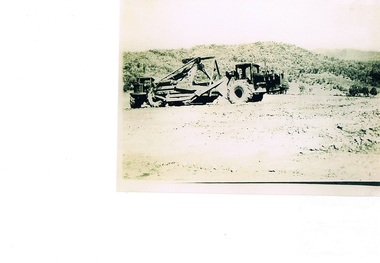 Kiewa Valley Historical Society
Photograph Tournapull, Tournapull C Scraper/Single Bucket, circa 1950
The machinery in this photo shows a Tournapull C earth moving machine, one of many during this period Circa 1950 - 1960s when hydro electricity powered turbines were being constructed in both the Victoria and New South Wales Alps. This was Australia's answer to a non polluting supply of electricity for a fast growing city population. It was at this time that air pollution from coal powered furnaces was becoming more and more under attack by health authorities.This item is part of a visual account of the construction of dams and hydro electricity facilities during the early 1950s. It was the beginning of the environmental push not to allow the degrading of Australian Alpine regions. Air pollution of the major cities and the increase in power demands of both industries and population within them required an alternative pollution free alternative electricity supply. These for runners of Hydro electricity generators required both large supplies of machinery and human resources. This construction phase within the region brought not only tradesmen but also unskilled workers to an area which had mainly had farming and mining activities. It was the catalyst for the creation of the smaller towns/villages e.g. Bogong Village, Mount Beauty and Bright.Black and white photograph on Kodak Xtralite II paper.(gloss)paper marking on back Kodak Xtralite II papermining, hydro electricity, victorian alps, construction camps, earth moving machines, secv -
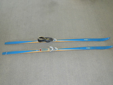 Kiewa Valley Historical Society
Skis Snow Competition, circa 1966
The post World War II migration of European "snow skiiers" into Australia combined with the construction of Hydo Electricity Schemes in both the N.S.W.and Victorian Alps regions, opened up these winter snow areas to a greater influx of tourists and holiday adventurers interested in "winter" sports. The ability to project, on a global scale, skiing facilities of international standards to those in the northern hemisphere during their summer has opened up the Australia ski resorts and their facilities to a much greater winter sport orientated population. These cross country skis were purchased by a member of the Bogong Ski Club and were part of a bulk ski stock consignment from Finland in 1966/67. They were introduced into the Victorian Alps to encourage skiers to take up cross country skiing both at Falls Creek and Mount Buller. This initiative spurred on the now annual 42 kilometre cross country "Kangaroo Hoppet" race at Falls Creek. This race is currently the biggest cross country snow skiing race in Australia. These snow skis were made in Finland. They are wooden (hickory) skis and made from four strips (glued and shaped) pieces of wood that are not laminated. There is a painted blue flash on the top of the skis that extends the full length of the skis. The face of the underside of the skis is flat and is coated in black Stockholm tar. Glider or grip wax was applied onto this base. The top body of the skis is tapered from shoe position to both front and back tips.Tapered curvatures from foot radiating to all sides provides the required aerodynamics. Metal boot bindings consisting of a toe plate with adjustable toe clip and a heel plate, both of which are screwed onto the skis. "KILPA, KARHU URHEILUTARPEITA SPORTART1KLAR, Karhu-Valtz Finland. Hickorypohjin"snow skiing, cross country skiing, falls creek winter tourism -
 Bendigo Historical Society Inc.
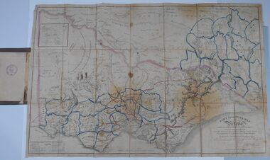
Document - HARRIS COLLECTION: HAMS SQUATTING MAP OF VICTORIA, PORT PHILLIP DISTRICT, NSW
Thomas Ham was a cartographer, engraver, lithographer and publisher in Victoria and Queensland. He compiled and printed several editions of his squatting map, beginning with A map of Australia Felix in 1847 and changing its title to Ham's squatting map of Victoria in 1851. The 1851 edition was accompanied by a key listing the names of all the squatters within squatting districts and counties. Later editions show the existing counties, but some areas of Gippsland and the Australian Alps are still described as 'unsurveyed country'. (State Library Victoria https://www.slv.vic.gov.au/squatting-map-victoria)Folding map enclosed in burgundy cover. Map backed by cloth and bound. Rare, early map of Victoria and neighbouring Port Phillip District of New South Wales. Written on bottom RH corner of map: Ham's Squatting Map of Victoria ( Port Phillip District, New South Wales ) carefully corrected to this date from the Colonial Government Surveys, Crown Lands, Commissioners & Explorers Maps, Private Surveys & c. Respectfully inscribed (with permission ) to His Excellency Sir Chas A. Fitz-Roy Knt, Governor of New South Wales &c &c by his Obedient Servant, The Compiler, 1851. Compiled, engraved and published by Thomas Ham, Melbourne. Proposed and original boundary ( in legend) have been coloured in in blue and pink ink ( later addition ?) Number on map show 'reference to proprietor's Printed on back of map ' J.G. AD 1852, with two cross hatched decorations and two hearts entwined. On other back panel in pencil enclosed in a drawn frame ' G.S.H., 1889, Axedale' (George Harris, Axedale, belongs in Harris Collection) Stamped in purple ink 'Royal Historical Society of Victoria, Bendigo Branch. Written 1959, 53.map, victoria, squatting map -
 Melbourne Legacy
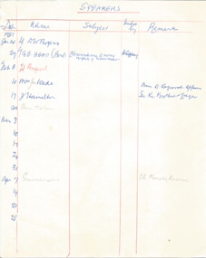
Document - Document, notes, Speakers, 1977-1981
List depicts a wide variety of prospective guest speakers that spoke at Tuesday luncheons between 1977 and 1981. Their subjects were noted down and the remarks column included comments such as "Excellent / Good / Fair ". Subjects included: Gallipoli; The Shrine of Remembrance; The Swiss Alps -with slides; Tattooing the history and social significance of; supporting the army in the 80s; people of India. Legatees met regularly and had guest speakers to entertain and inform on different subjects at their Tuesday Luncheons. This document was from a file of information about guest speakers (see also 00812-00822 and 00829-00837). The Programme Committee was responsible for organising the speakers. A record that the speakers at Legacy functions were from very different walks of life and the subjects spoken on varied. Much time and effort would go into contacing and organising guest speakers and the topics that they would speak on.White note paper x 9 pages, handwritten tables of dates and speakers and remarks in blue and red pen.Handwritten list of speakers for Tuesday luncheons.speakers, legatee event, programme committee -
 Kiewa Valley Historical Society
Maps, Unknown
There are 2 maps: 1. Broadbent's Makers of Maps since 1896, No. 323 Across the Alps/Official Copyright Map./ The cover is blue, green and orange with advertising for Ólympic' and 'Bosch' and there is further advertising on the fold out covers/ 2/-. 2. Robinson's Kiewa Hydro-Electric Scheme & Hotham Heights Map No. 613, with Insets of: Bright, Mt Beauty, Falls Creek Ski Village, Hotham Heights Ski Village/ the cover is blue, green and orange with image of skier, hydro tower and locality map./Other fold out sides have advertising and information for tourists./ 4/-.maps, tourism, kiewa hydro electric scheme, victorian alps, skiing -
 Kiewa Valley Historical Society
Postcard Circa 1950, Snow Plough, Bogong High Plain,5,500 Feet Kiewa Hydro-Electric Project, Circa 1950
This postcard was produced in the 1950's for the tourist trade in the Kiewa Valley and Alpine region. It encompasses the period when the State of Victoria was pressured by the ever increasing demand by industry and its population for electricity supplies. Hydro electricity was seen as an untapped natural resource to quench this demand. The Victorian Alps and the rivers flowing into its valleys was ideal for the construction of the Kiewa Hydro Electricity Scheme. The late 1940's saw the development of this scheme and the changing of sections of alpine landscape is covered by this and other postcards/pictures (tourists, construction workers, and established rural populations). This period in time was before the established wildlife and forest/nature groups became political activist who changed legislative acts to protect the environment. This rural region (Kiewa Valley/alpine plains) was at most only significant to a smaller group of winter sports, summer hikers/horse riders and rural farmers/graziers. The numbers of tourists and the increase in the local resident population was boosted by the construction of the Hydro Electricity Scheme. This influx to the regional population resulted in a corresponding diversity in services and brought about an environment that responded to a growing level of tourists and thereby permitting this industry to grow more rapidly than it would have naturally. This postcard details an attraction to the "cleaner" method of providing electricity. This postcard was purchased in 1950 by a surveyor at Landford's Gap. This item is a black and white photograph(professional) of a panoramic view of a snow plough clearing the unsealed road in 1950.This postcard is on quality paper and the reproduction of the picture is of a high standard.For other "tourist" postcards see 0480 (A) -(F) for other photos of similar postcards. kiewa valley tourism, victorian alps, alternate energy supplies, alpine population growth, secv, snow plough -
 Kiewa Valley Historical Society
Postcard Circa 1950, Road to Bogong High Plains Kiewa Hydro Electric Project, Circa 1950's
This postcard was produced in the 1950's for the tourist trade in the Kiewa Valley and Alpine region. It encompasses the period when the State of Victoria was pressured by the ever increasing demand by industry and its population for electricity supplies. Hydro electricity was seen as an untapped natural resource to quench this demand. The Victorian Alps and the rivers flowing into its valleys was ideal for the construction of the Kiewa Hydro Electricity Scheme. The late 1940's saw the development of this scheme and the changing of sections of alpine landscape is covered by this and other postcards/pictures (tourists, construction workers, and established rural populations). This period in time was before the established wildlife and forest/nature groups became political activist who changed legislative acts to protect the environment.This rural region (Kiewa Valley/alpine plains) was at most only significant to a smaller group of winter sports, summer hikers/horse riders and rural farmers/graziers. The numbers of tourists and the increase in the local resident population was boosted by the construction of the Hydro Electricity Scheme. This influx to the regional population resulted in a corresponding diversity in services and brought about an environment that responded to a growing level of tourists and thereby permitting this industry to grow more rapidly than it would have naturally. This postcard details an attraction to the "cleaner" method of providing electricity. This postcard was purchased in 1950 by a surveyor at Landford's Gap.This black and white photograph on a Valentine's postcard is from a V2 Argus photograph.. It is on a 200g/m paper density photo side gloss. See 0480 (A) - (G) for other photos of similar postcards.In white lettering " ROAD TO BOGONG HIGH PLAINS KIEWA HYDRO-ELECTRIC PROJECT", V3secv, road making, victorian alps -
 Kiewa Valley Historical Society
Postcard - Rocky Valley - Circa 1950, 1950
This postcard was produced in the 1950's for the tourist trade in the Kiewa Valley and Alpine region. It encompasses the period when the State of Victoria was pressured by the ever increasing demand by industry and its population for electricity supplies. Hydro electricity was seen as an untapped natural resource to quench this demand. The Victorian Alps and the rivers flowing into its valleys was ideal for the construction of the Kiewa Hydro Electricity Scheme. The late 1940's saw the development of this scheme and the changing of sections of alpine landscape is covered by this and other postcards/pictures (tourists, construction workers, and established rural populations). This period in time was before the established wildlife and forest/nature groups became political activist who changed legislative acts to protect the environment.This rural region (Kiewa Valley/alpine plains) was at most only significant to a smaller group of winter sports, summer hikers/horse riders and rural farmers/graziers. The numbers of tourists and the increase in the local resident population was boosted by the construction of the Hydro Electricity Scheme. This influx to the regional population resulted in a corresponding diversity in services and brought about an environment that responded to a growing level of tourists and thereby permitting this industry to grow more rapidly than it would have naturally. This postcard details an attraction to the "cleaner" method of providing electricity. This postcard was purchased in 1950 by a surveyor at Landford's Gap.This black and white photograph is from a Valentine's V2 Argus postcard. It is on a 200g/m paper density one side gloss. See also KVHS 0480 (A) to (L) for similar postcards. "ROCKY VALLEY FROM BOGONG HIGH PLAINS KIEWA HYDRO-ELECTRIC PROJECT" "V1"kiewa valley tourism, victorian alps, alternate energy supplies, alpine population growth, rocky valley, secv -
 Kiewa Valley Historical Society
Postcard - Junction Dam - Circa 1950, Circa 1950's
This postcard was produced in the 1950's for the tourist trade in the Kiewa Valley and Alpine region. It encompasses the period when the State of Victoria was pressured by the ever increasing demand by industry and its population for electricity supplies. Hydro electricity was seen as an untapped natural resource to quench this demand. The Victorian Alps and the rivers flowing into its valleys was ideal for the construction of the Kiewa Hydro Electricity Scheme. The late 1940's saw the development of this scheme and the changing of sections of alpine landscape is covered by this and other postcards/pictures (tourists, construction workers, and established rural populations). This period in time was before the established wildlife and forest/nature groups became political activist who changed legislative acts to protect the environment.This rural region (Kiewa Valley/alpine plains) was at most only significant to a smaller group of winter sports, summer hikers/horse riders and rural farmers/graziers. The numbers of tourists and the increase in the local resident population was boosted by the construction of the Hydro Electricity Scheme. This influx to the regional population resulted in a corresponding diversity in services and brought about an environment that responded to a growing level of tourists and thereby permitting this industry to grow more rapidly than it would have naturally. This postcard details an attraction to the "cleaner" method of providing electricity. This postcard was purchased in 1950 by a surveyor at Landford's Gap.This black and white photograph is a Valentine's postcard, from a V2 Argus photograph. It is on a 200g/m paper density with only the photo side gloss.Front "JUNCTION DAM & SPILLWAY, BOGONG KIEWA HYDRO-ELECTRIC PROJECT" on the flip side "VALENTINE'S POST CARD " "A GENUINE PHOTOGRAPH"kiewa valley tourism, victorian alps, alternate energy supplies, alpine population growth, junction dam, secv -
 Kiewa Valley Historical Society
Postcard - Junction Dam - Circa 1950, Circa 1950
This postcard was produced in the 1950's for the tourist trade in the Kiewa Valley and Alpine region. It encompasses the period when the State of Victoria was pressured by the ever increasing demand by industry and its population for electricity supplies. Hydro electricity was seen as an untapped natural resource to quench this demand. The Victorian Alps and the rivers flowing into its valleys was ideal for the construction of the Kiewa Hydro Electricity Scheme. The late 1940's saw the development of this scheme and the changing of sections of alpine landscape is covered by this and other postcards/pictures (tourists, construction workers, and established rural populations). This period in time was before the established wildlife and forest/nature groups became political activist who changed legislative acts to protect the environment.This rural region (Kiewa Valley/alpine plains) was at most only significant to a smaller group of winter sports, summer hikers/horse riders and rural farmers/graziers. The numbers of tourists and the increase in the local resident population was boosted by the construction of the Hydro Electricity Scheme. This influx to the regional population resulted in a corresponding diversity in services and brought about an environment that responded to a growing level of tourists and thereby permitting this industry to grow more rapidly than it would have naturally. This postcard details an attraction to the "cleaner" method of providing electricity. This postcard was purchased in 1950 by a surveyor at Landford's Gap.This black and white photograph on a Valentine's postcard is from a V2 Argus photograph. It is on a 200g/m paper density one side gloss only/. See 0480 (A) -(L) for other photos of similar postcards."JUNCTION DAM & SPILLWAY, LAKE GUY, BOGONG, KIEWA HYDRO-ELECTRIC PROJECT" "V5" on the flip side" VALENTINE'S POST CARD " "A GENUINE PHOTOGRAPH"kiewa valley tourism, victorian alps, alternate energy supplies, alpine population growth, junction dam, secv