Showing 446 items
matching andrew land
-
 Flagstaff Hill Maritime Museum and Village
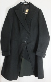
Clothing - Riding Habit, jacket, Early 20th Century
The Manifolds were a significant pioneering pastoral family in Western Victoria. The donated riding jacket originally belonged to Mrs Edward Manifold, formally Beatrice Mary Synnot Anderson. Beatrice was Edward Manifold’s cousin once removed whom he married in 1900. Edward, the son of John Manifold, was born on 15 November 1868 and educated at Geelong and Melbourne Grammar schools and at Trinity Hall, Cambridge (B.A., 1891). He chose the Danedite portion of land at Purrumbete, and on the death of his bachelor brother Thomas Peter (1863-1895), after a hunting accident, he took over his allocation, Wiridgil. He also owned Boortkoi, near Hexham and on these properties, he ran merino sheep, a Lincoln stud which dated back to 1870, and Shorthorn cattle. 3000 acres were also leased to dairy farmers. Edward was a member of Hampden Shire Council in 1909-31 and three times president at Camperdown. The town was largely bordered by Manifold land and partly dependent upon the local pastoral dynasties, which benefited the local area from the families’ various business interests. Though an offer to build public baths to commemorate the Queen Victoria Jubilee in 1897 was not proceeded with, the town acquired a hospital, a reserve on Mount Leura, a clock tower and a cricket pavilion, as well as notable donations from the Manifolds to St Paul's Church and the grammar school. Edward was a keen polo player and racing man. He was also a successful owner of steeplechasers and a committeeman of the Victoria Racing Club for many years. He was also a member of many Western District racing clubs. On the 16 July 1900, Edward had married his sixteen-year-old cousin Beatrice Mary Synnot Anderson by whom he had three sons Thomas Peter, Andrew and Robert Edward Manifold. Edwards's estate at his death was valued for probate at nearly £500,000. Edward died following an operation on 14 February 1931 at a private hospital in Yarra Vale Melbourne. Beatrice passed away in 1954, aged 79 in Ballarat where she was born in 1874. Contextual historic Family background: The Manifold brothers Thomas (1809-1875), John (1811-1877) and Peter (1817-1885) were the fourth, fifth and sixth sons of William Manifold and Mary, nee Barnes, of Courthouse Farm, Bromborough, Cheshire, England. The family had decided to emigrate to Van Diemen's Land. Thomas was sent ahead, arriving in Hobart Town on 23rd January 1828 with £1500 and a letter of recommendation from the Colonial Office. Thomas acquired 1280 acres on the west bank of the Tamar River. John and Peter, with their parents and three sisters, arrived on 8th July 1831. Land grants by then had finished but William brought ninety acres next to his son Thomas’ land and on the combined properties the family built Kelso House. The Manifolds’ properties were comparatively poor and when news of the Port Phillip District, in Victoria reached Thomas, he lost no time in coming to see for himself in February 1836. He was impressed with what he saw and hurried back to Tasmania to buy lambs and ewes. With one of his brothers, on July 9th he landed his stores at Point Henry and proceeded to occupy both sides of the Moorabool River. Thomas, at the end of the year, returned to Tasmania and left Peter and John to run the new property. Thomas, however, returned to Victoria for several visits and on one of these visits he, along with his brothers, examined the country near Ballarat. In December 1838 they managed to penetrate the Stony Rises, and Peter and John reached Lake Purrumbete and the Mount Leura country. During this time, on 4th July 1838, Thomas married Jane Elizabeth, eldest daughter of Captain Walter Synnot, formerly of Ballinate, County Armagh, Ireland, and then of Van Diemen's Land. Thomas joined his brothers, and they occupied the Purrumbete run in January 1839. On the journey to Purrumbete they could not take their stock and drays through the Stony Rises, so went north of Lake Corangamite, to the neck of land between it and Lake Gnarpurt. By April the move from Moorabool area was complete. As yet they had no hut and were working day and night, but their delight in their new run was unbounded. John wrote to his mother: “We are at last got to the land we wished for it is a beautiful place, and cannot be surpassed by any I have ever seen”. The three brothers occupied Purrumbete together, breeding both sheep and cattle until Thomas went to Grassmere run on the Merri River near Warrnambool in 1844. John and Peter soon gave up breeding sheep but retained the well-known '3M' brand for the cattle. These were Shorthorns, derived from four bulls originally imported by the Boldon brothers and later improved by further importations, and were renowned for size and quality. By the time of the gold rush in 1851, John and Peter were breeding over 1000 head a year, as well as fattening stores. The diggings at this time had disorganised Grassmere by drawing away Thomas's men, and his wife decided to take her two sons and two daughters to Europe for their education. Thomas gave up the property next year, went to England to join his family, and eventually brought the family back to live in Melbourne. At Purrumbete things were different. The brothers, John and Peter, preferred black stockmen to white, so the discovery of gold upset them very little while providing the very market they required. John was on his second visit to England when the rush started, and Peter went in his turn soon after John returned. On 2 September 1856 John married Marion Thomson, at Cormiston, Van Diemen's Land. They had four daughters and five sons, from three of whom, William Thomson, James Chester and Edward, the later generations of the family descend. Through the years the brothers had to contend with the scab, fluke and footrot, depression, rabbits, bush fires and pleuro-pneumonia. In 1861 they appointed as manager Henry Manifold Matson, their nephew, who had already been with them for five years. Thomas died in Melbourne on 7 November 1875, John at Purrumbete on 3 January 1877 and Peter at Purrumbete on 31 July 1885. Devout members of the Church of England, John and Peter, during their lives, gave generously towards building St Paul's Church, Camperdown, and guaranteed part of the vicar's stipend. Peter was a member of the Hampden and Heytesbury Roads Board from 1859 and carried on into the Hampden Shire Council when it was formed in 1864. However, it was not for public works that they were known, but for their personal example. In a new land where speculators and adventurers were all too common, the Manifold brothers were among those who intended it to be their home and their children's home. Industrious, unpretentious and hospitable, they were respected in their community as men of the highest integrity. This riding habit is a characteristic example of the type and style of riding clothes that well-dressed ladies wore in the 1920s. It highlights the changes that were beginning in society for women. Prior to 1918 ladies still had to ride side-saddle with skirts over Jodhpurs. Society of the time regarded women riding astride as unseemly and just not done. This riding habit is particularly significant on a number of levels, it shows the beginnings of change in society's attitudes through women's fashion after the First World War. A change that was to bring a start to a more liberating societal attitude towards women after the successful establishment of the Representation of People Act 1918 that gave women the right to vote. This garments provenance is linked to one of Victoria's important pioneering families the Manifolds, one of the first families that came from Van Diemen's land to settle the Western District of Victoria in 1844. Originally the garment belonged to the wife of the great-grandson of pioneer William Manifold, Edward Manifold who married Beatrice May Synnot Anderson, Edwards Cousin in 1900. The garment was made by the Mayfair tailors J. Busvine & Co. in the early to mid-1920s (estimate) who at the turn of the century were tailors to the Courts of Europe. Their clothing is highly collectible today and examples can be found in a number of significant museum collections around the world, notably the Metropolitan Museum of Art in New York and the FIDM in Los Angeles. A riding jacket, part of a three-piece, side saddle riding habit tailored for Mrs Edward Manifold. Knee length English woolen jacket black in colour, seamed and fitted to the female client's figure, fastening from the waist with three bone buttons to rather high lapels. The sleeves are long with closely fitted cuffs and one button and lined with cream satin. The jacket is fitted to the waist and flared to below the hips with a 35 cm vent to the back. Lower back to the jacket is reinforced with removable fabric and the jacket is lined with black twill cotton, there is a cream satin label, with makers' emblem Busvine. Circa 1920s Label to Jacket Embroidered in gold with a Royal logo on a Cream Satin label “By Special /Appointment” “To Her Majesty/The Queen”, “Busvine / Ltd / London 4 Brook St. W. / No” “hand written in purple ink 315 / Mrs Edward Manifold”flagstaff hill, warrnambool, shipwrecked coast, flagstaff hill maritime museum, maritime museum, side saddle riding habit, mrs edward manifold, edward manifold, busvines, shipwreck coast, flagstaff hill maritime village, great ocean road -
 Flagstaff Hill Maritime Museum and Village
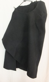
Clothing - Riding Habit, Skirt, 1920s
The Manifolds were a significant pioneering pastoral family in Western Victoria. The donated riding skirt originally belonged to Mrs Edward Manifold, formally Beatrice Mary Synnot Anderson. Beatrice was Edward Manifold’s cousin once removed whom he married in 1900. Edward, the son of John Manifold, was born on 15 November 1868 and educated at Geelong and Melbourne Grammar schools and at Trinity Hall, Cambridge (B.A., 1891). He chose the Danedite portion of land at Purrumbete, and on the death of his bachelor brother Thomas Peter (1863-1895), after a hunting accident, he took over his allocation, Wiridgil. He also owned Boortkoi, near Hexham and on these properties, he ran merino sheep, a Lincoln stud which dated back to 1870, and Shorthorn cattle. 3000 acres were also leased to dairy farmers. Edward was a member of Hampden Shire Council in 1909-31 and three times president at Camperdown. The town was largely bordered by Manifold land and partly dependent upon the local pastoral dynasties, which benefited the local area from the families’ various business interests. Though an offer to build public baths to commemorate the Queen Victoria Jubilee in 1897 was not proceeded with, the town acquired a hospital, a reserve on Mount Leura, a clock tower and a cricket pavilion, as well as notable donations from the Manifolds to St Paul's Church and the grammar school. Edward was a keen polo player and racing man. He was also a successful owner of steeplechasers and a committeeman of the Victoria Racing Club for many years. He was also a member of many Western District racing clubs. On the 16 July 1900, Edward had married his sixteen-year-old cousin Beatrice Mary Synnot Anderson by whom he had three sons Thomas Peter, Andrew and Robert Edward Manifold. Edwards's estate at his death was valued for probate at nearly £500,000. Edward died following an operation on 14 February 1931 at a private hospital in Yarra Vale Melbourne. Beatrice passed away in 1954, aged 79 in Ballarat where she was born in 1874. Contextual historic Family background: The Manifold brothers Thomas (1809-1875), John (1811-1877) and Peter (1817-1885) were the fourth, fifth and sixth sons of William Manifold and Mary, nee Barnes, of Courthouse Farm, Bromborough, Cheshire, England. The family had decided to emigrate to Van Diemen's Land. Thomas was sent ahead, arriving in Hobart Town on 23rd January 1828 with £1500 and a letter of recommendation from the Colonial Office. Thomas acquired 1280 acres on the west bank of the Tamar River. John and Peter, with their parents and three sisters, arrived on 8th July 1831. Land grants by then had finished but William brought ninety acres next to his son Thomas’ land and on the combined properties the family built Kelso House. The Manifolds’ properties were comparatively poor and when news of the Port Phillip District, in Victoria reached Thomas, he lost no time in coming to see for himself in February 1836. He was impressed with what he saw and hurried back to Tasmania to buy lambs and ewes. With one of his brothers, on July 9th he landed his stores at Point Henry and proceeded to occupy both sides of the Moorabool River. Thomas, at the end of the year, returned to Tasmania and left Peter and John to run the new property. Thomas, however, returned to Victoria for several visits and on one of these visits he, along with his brothers, examined the country near Ballarat. In December 1838 they managed to penetrate the Stony Rises, and Peter and John reached Lake Purrumbete and the Mount Leura country. During this time, on 4th July 1838, Thomas married Jane Elizabeth, eldest daughter of Captain Walter Synnot, formerly of Ballinate, County Armagh, Ireland, and then of Van Diemen's Land. Thomas joined his brothers, and they occupied the Purrumbete run in January 1839. On the journey to Purrumbete they could not take their stock and drays through the Stony Rises, so went north of Lake Corangamite, to the neck of land between it and Lake Gnarpurt. By April the move from Moorabool area was complete. As yet they had no hut and were working day and night, but their delight in their new run was unbounded. John wrote to his mother: “We are at last got to the land we wished for it is a beautiful place, and cannot be surpassed by any I have ever seen”. The three brothers occupied Purrumbete together, breeding both sheep and cattle until Thomas went to Grassmere run on the Merri River near Warrnambool in 1844. John and Peter soon gave up breeding sheep but retained the well-known '3M' brand for the cattle. These were Shorthorns, derived from four bulls originally imported by the Boldon brothers and later improved by further importations, and were renowned for size and quality. By the time of the gold rush in 1851, John and Peter were breeding over 1000 head a year, as well as fattening stores. The diggings at this time had disorganised Grassmere by drawing away Thomas's men, and his wife decided to take her two sons and two daughters to Europe for their education. Thomas gave up the property next year, went to England to join his family, and eventually brought the family back to live in Melbourne. At Purrumbete things were different. The brothers, John and Peter, preferred black stockmen to white, so the discovery of gold upset them very little while providing the very market they required. John was on his second visit to England when the rush started, and Peter went in his turn soon after John returned. On 2 September 1856 John married Marion Thomson, at Cormiston, Van Diemen's Land. They had four daughters and five sons, from three of whom, William Thomson, James Chester and Edward, the later generations of the family descend. Through the years the brothers had to contend with the scab, fluke and footrot, depression, rabbits, bush fires and pleuro-pneumonia. In 1861 they appointed as manager Henry Manifold Matson, their nephew, who had already been with them for five years. Thomas died in Melbourne on 7 November 1875, John at Purrumbete on 3 January 1877 and Peter at Purrumbete on 31 July 1885. Devout members of the Church of England, John and Peter, during their lives, gave generously towards building St Paul's Church, Camperdown, and guaranteed part of the vicar's stipend. Peter was a member of the Hampden and Heytesbury Roads Board from 1859 and carried on into the Hampden Shire Council when it was formed in 1864. However, it was not for public works that they were known, but for their personal example. In a new land where speculators and adventurers were all too common, the Manifold brothers were among those who intended it to be their home and their children's home. Industrious, unpretentious and hospitable, they were respected in their community as men of the highest integrity. This riding habit is a characteristic example of the type and style of riding clothes that well-dressed ladies wore in the 1920s. It highlights the changes that were beginning in society for women. Prior to 1918 ladies still had to ride side-saddle with skirts over Jodhpurs. Society of the time regarded women riding astride as unseemly and just not done. This riding habit is particularly significant on a number of levels, it shows the beginnings of change in society's attitudes through women's fashion after the First World War. A change that was to bring a start to a more liberating societal attitude towards women after the successful establishment of the Representation of People Act 1918 that gave women the right to vote. This garments provenance is linked to one of Victoria's important pioneering families the Manifolds, one of the first families that came from Van Diemen's land to settle the Western District of Victoria in 1844. Originally the garment belonged to the wife of the great-grandson of pioneer William Manifold, Edward Manifold who married Beatrice May Synnot Anderson, Edwards Cousin in 1900. The garment was made by the Mayfair tailors J. Busvine & Co. in the early to mid-1920s (estimate) who at the turn of the century were tailors to the Courts of Europe. Their clothing is highly collectible today and examples can be found in a number of significant museum collections around the world, notably the Metropolitan Museum of Art in New York and the FIDM in Los Angeles. Safety skirt/apron, part of a three-piece, side saddle riding habit tailored for Mrs Edward Manifold. This side saddle skirt is made from black woolen material fixing at the waist with two metal hooks and three buttons to the front opening. One internal concealed pocket lining to the top part of the apron made of cotton the seat is shaped for side saddle riding and the skirt wraps around the body the longer side draped over the leg that is in the stirrup. flagstaff hill, warrnambool, shipwrecked coast, flagstaff hill maritime museum, maritime museum, side saddle riding habit, side saddle safety skirt, side saddle apron, mrs edward manifold, beatrice manifold, female riding habit 1920s, shipwreck coast, flagstaff hill maritime village, great ocean road -
 Phillip Island and District Historical Society Inc.
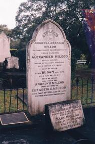
Photograph Album, Kodak, Phillip Island Cemetery, c 1889
The Album was compiled by Nancy McHaffie late 1990's, with the assistance of Edith Jeffery's, with her book "Garden of Memories" and extensive knowledge of Phillip Island. The Cemetery lies back from the road and is surrounded by Manna Gums, rare Peppermint Gums, Blackwoods and other native trees. In all 25 acres of land were set aside as Crown Land in the land settlement of 1868. There are 6.2 acres of wetlands near the cemetery entrance.Captain McLeod: Captain McLeod and family kept the Post Office at Newhaven. He also built a boat called old "Trusty" and launched it almost opposite Churchill Island. Unfortunately, at a later date, the "Trusty" was the cause of a tragedy. The bottom of the boat had become so encrusted with marine growth that the owner decided to beach her between the jetties at Griffiths point, now San Remo. Before the job was completed the soring gave way and allowed the boat to tip over on her side, causing Captain McLeod to be crushed to death. Died March 3rd 1880 aged 64 years. Also buried in this grave is his wife Susan - died May 24th 1882 aged 62 years. Their son Andrew McLeod died February 21st 1916 aged 60 - loved husband of Elizabeth E McLeod. Alexander was Captain of the "Genista" for 12 years.phillip island cemetery, captain alexander mcleod, susan mcleod, andrew mcleod, nancy mchaffie, edith jeffery -
 Greensborough Historical Society
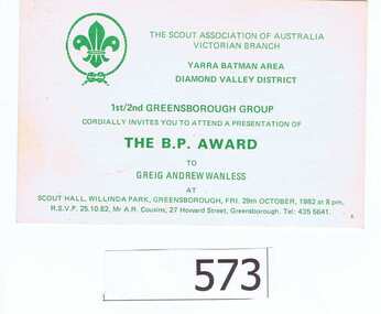
Invitation, The B.P. Award to Greig Wanless, 29/10/1982
Issued by the 1st/2nd Greensborough Group as an invitation to an award ceremony. Greig Andrew Wanless was to receive the BP Award on 29/10/1982.The Greensborough Scout Group have had a long history with the youth of the area. The Wanless family held a large area of land to the immediate north of the township.An invitation on white card with green printing.Nilwanless, greig wanless, scouting, diamond valley district, greensborough group, the bp award -
 City of Moorabbin Historical Society (Operating the Box Cottage Museum)
Document - Genealogy Chart Henry Dendy (Photocopy), 19 thC
In 1840 Henry Dendy, a farmer in Surrey, England acquired a "Special Survey" from the Commissioners for Land and Emigration which gave Dendy the right to choose land in Port Phillip for the "bargain basement" price of only £1 per acre for 5120 acres, (an area of 8 square miles). The Special Survey also included the right to "the shipment of a worker for every £20 spent on land, whose free passage was paid by the Crown, equalling a total of 100 workers ". Accordingly Dendy sold his English holdings and paid the required £5120 and arrived in Melbourne in February 1841. However by this time land in the new colony was selling for £5 - £40 per acre. Because Henry Dendy possessed the order from the Colonial Office in London he was able to successfully oppose Super-intendant LaTrobe's attempts to alter the price of the land. Dendy appointed Jonathan Were, (an entrepreneur, who had arrived in 1839), as his Manager and who later became a partner. Together, Dendy and Were decided on an area 5 miles south from Melbourne, bounded by North Road, East Boundary Road, South Road and to the west by Port Phillip Bay. Were and Dendy pitched their tents in the area now known as ' Park St, Brighton' and sank a well near the corner of 'St Andrew's St and Wells St'. By 1845 J.B Were and Company had bought almost half of Dendy's land and Were built himself "Moorabbin House" in Were St Brighton made from stone, quarried from local cliffs. It was still standing in 1924. Legend records Moorabbin is named after the Aboriginal word for ' Mother's Milk ' The soil is very fertile and well supplied with water especially in the area called 'East Brighton' - now known as Bentleigh and East Bentleigh - By 1850 the area had developed with numerous market gardens, dairy farms, fruit gardens and vineyards supplying food for the growing population of Melbourne.In 1840 Henry Dendy, a farmer in Surrey, England acquired a "Special Survey" from the Commissioners for Land and Emigration which gave Dendy the right to choose land in Port Phillip for the price of only £1 per acre for 5120 acres. This land was called Brighton in the Parish of Moorabbin, County of Bourke and emigrants developed the land establishing market gardens , dairy and poultry farms that provided the food for the growing population of Melbourne. A photocopy of the Genealogy Chart of the Dendy Family that Henry Dendy brought with him when he emigrated to Melbourne 1841Genealogy signs and descriptionsdendy henry, dendy's special survey brighton 1841, governor gipps, captain lonsdale, super-intendant latrobe, port phillip, melbourne, new south wales, squatters, emmigrants, county of bourke, parish of moorabbin, early settlers, pioneers, market gardeners, dairy farmers, fruit farms, moorabbin, bentleigh, brighton, cheltenham, were jonathan binn, -
 City of Moorabbin Historical Society (Operating the Box Cottage Museum)
Document, Henry Dendy family Shield
In 1840 Henry Dendy, a farmer in Surrey, England acquired a "Special Survey" from the Commissioners for Land and Emigration which gave Dendy the right to choose land in Port Phillip for the "bargain basement" price of only £1 per acre for 5120 acres, (an area of 8 square miles). The Special Survey also included the right to "the shipment of a worker for every £20 spent on land, whose free passage was paid by the Crown, equalling a total of 100 workers ". Accordingly Dendy sold his English holdings and paid the required £5120 and arrived in Melbourne in February 1841. However by this time land in the new colony was selling for £5 - £40 per acre. Because Henry Dendy possessed the order from the Colonial Office in London he was able to successfully oppose Super-intendant LaTrobe's attempts to alter the price of the land. Dendy appointed Jonathan Were, (an entrepreneur, who had arrived in 1839), as his Manager and who later became a partner. Together, Dendy and Were decided on an area 5 miles south from Melbourne, bounded by North Road, East Boundary Road, South Road and to the west by Port Phillip Bay. Were and Dendy pitched their tents in the area now known as ' Park St, Brighton' and sank a well near the corner of 'St Andrew's St and Wells St'. By 1845 J.B Were and Company had bought almost half of Dendy's land and Were built himself "Moorabbin House" in Were St Brighton made from stone, quarried from local cliffs. It was still standing in 1924. Legend records Moorabbin is named after the Aboriginal word for ' Mother's Milk ' The soil is very fertile and well supplied with water especially in the area called 'East Brighton' - now known as Bentleigh and East Bentleigh - By 1850 the area had developed with numerous market gardens, dairy farms, fruit gardens and vineyards supplying food for the growing population of Melbourne. dendy henry, dendy's special survey brighton 1841, governor gipps, captain lonsdale, super-intendant latrobe, port phillip, melbourne, new south wales, squatters, emmigrants, county of bourke, parish of moorabbin, early settlers, pioneers, market gardeners, dairy farmers, fruit farms, moorabbin, bentleigh, brighton, cheltenham, were jonathan binn, -
 City of Moorabbin Historical Society (Operating the Box Cottage Museum)
Document - Pedigree of Henry Dendy, c1840 Original ; Copy 1985
This is a copy of the document brought by Henry Dendy to the Colony in 1841. In 1840 Henry Dendy, a farmer in Surrey, England acquired a "Special Survey" from the Commissioners for Land and Emigration which gave Dendy the right to choose land in Port Phillip for the "bargain basement" price of only £1 per acre for 5120 acres, (an area of 8 square miles). The Special Survey also included the right to "the shipment of a worker for every £20 spent on land, whose free passage was paid by the Crown, equalling a total of 100 workers ". Accordingly Dendy sold his English holdings and paid the required £5120 and arrived in Melbourne in February 1841. However by this time land in the new colony was selling for £5 - £40 per acre. Because Henry Dendy possessed the order from the Colonial Office in London he was able to successfully oppose Super-intendant LaTrobe's attempts to alter the price of the land. Dendy appointed Jonathan Were, (an entrepreneur, who had arrived in 1839), as his Manager and who later became a partner. Together, Dendy and Were decided on an area 5 miles south from Melbourne, bounded by North Road, East Boundary Road, South Road and to the west by Port Phillip Bay. Were and Dendy pitched their tents in the area now known as ' Park St, Brighton' and sank a well near the corner of 'St Andrew's St and Wells St'. By 1845 J.B Were and Company had bought almost half of Dendy's land and Were built himself "Moorabbin House" in Were St Brighton made from stone, quarried from local cliffs. It was still standing in 1924. Legend records Moorabbin is named after the Aboriginal word for ' Mother's Milk ' The soil is very fertile and well supplied with water especially in the area called 'East Brighton' - now known as Bentleigh and East Bentleigh - By 1850 the area had developed with numerous market gardens, dairy farms, fruit gardens and vineyards supplying food for the growing population of Melbourne. A copy of a paper chart of the Pedigree of Henry Dendy in a wooden frame with glassPedigree / of the branch of the family / DENDY moorabbin, brighton, henry dend special survey 1841 y, early settlers, pioneers, market gardeners -
 Eltham District Historical Society Inc
Photograph, George W. Bell, Birch Cottage, Yarra Glen Road, Smiths Gully, Aug 1969, Aug 1969
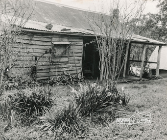
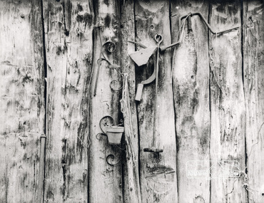
... of its location on Crown land. In 2007 the Andrew Ross Museum... of its location on Crown land. In 2007 the Andrew Ross Museum ...EDHS Newsletter No. 182, September 2008 In the late 1970s when our Society was the Shire of Eltham Historical Society, an offer was made to the Society regarding use of an old cottage at Christmas Hills. For various reasons the offer ultimately lapsed The cottage sat beside Watsons Creek just outside the then Shire of Eltham but following municipal restructuring it now lies within the Shire of Nillumbik. At that time some research on the cottage was carried out for the Society by Keith Chappel as part of a larger research project that he was doing. Keith's notes were taken from Lands Department records and showed that house is the subject of a permissive occupancy of Crown land comprising the creek reserve. In 1903 a Miners Right of one acre in area was granted to Edwin Samuel Birch. In 1907 Birch applied to purchase this land but was unable to because it was part of the creek reserve. The documents show that the house existed at that time. Birch died in 1932 and his daughter Honor Mary Birch was granted a permit to occupy the residence. The future of the cottage remains precarious because of its location on Crown land. In 2007 the Andrew Ross Museum began a campaign to ensure that it is preserved. It included a video presentation on the history of the cottage under the title of "This Old House- Birch Cottage". Black and white photographWilliams Cottage Panton Hill 1969 Not to be reproduced without permission G.W. Bell Photographer Elthamhouses, cottage, early settlers, yarra glen road, smiths gully, williams cottage, watsons creek, christmas hills, birch cottage, edwin samuel birch, honor mary birch -
 Eltham District Historical Society Inc
Photograph, George W. Bell, Detail, Kitchen, Birch Cottage, Yarra Glen Road, Smiths Gully, Aug 1969, Aug 1969
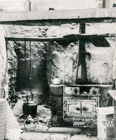
... of its location on Crown land. In 2007 the Andrew Ross Museum... of its location on Crown land. In 2007 the Andrew Ross Museum ...EDHS Newsletter No. 182, September 2008 In the late 1970s when our Society was the Shire of Eltham Historical Society, an offer was made to the Society regarding use of an old cottage at Christmas Hills. For various reasons the offer ultimately lapsed The cottage sat beside Watsons Creek just outside the then Shire of Eltham but following municipal restructuring it now lies within the Shire of Nillumbik. At that time some research on the cottage was carried out for the Society by Keith Chappel as part of a larger research project that he was doing. Keith's notes were taken from Lands Department records and showed that house is the subject of a permissive occupancy of Crown land comprising the creek reserve. In 1903 a Miners Right of one acre in area was granted to Edwin Samuel Birch. In 1907 Birch applied to purchase this land but was unable to because it was part of the creek reserve. The documents show that the house existed at that time. Birch died in 1932 and his daughter Honor Mary Birch was granted a permit to occupy the residence. The future of the cottage remains precarious because of its location on Crown land. In 2007 the Andrew Ross Museum began a campaign to ensure that it is preserved. It included a video presentation on the history of the cottage under the title of "This Old House- Birch Cottage". Black and white photographWilliams Cottage Panton Hill 1969 Not to be reproduced without permission G.W. Bell Photographer Elthamhouses, cottage, early settlers, yarra glen road, smiths gully, williams cottage, watsons creek, christmas hills, birch cottage, edwin samuel birch, honor mary birch -
 Eltham District Historical Society Inc
Photograph, George W. Bell, Detail, Cottage Entrance, Birch Cottage, Yarra Glen Road, Smiths Gully, Aug 1969, Aug 1969
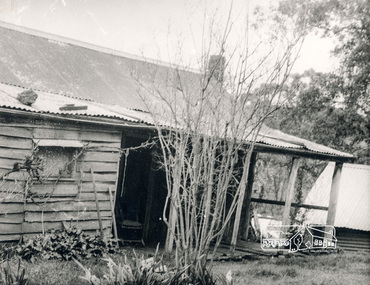
... of its location on Crown land. In 2007 the Andrew Ross Museum... of its location on Crown land. In 2007 the Andrew Ross Museum ...EDHS Newsletter No. 182, September 2008 In the late 1970s when our Society was the Shire of Eltham Historical Society, an offer was made to the Society regarding use of an old cottage at Christmas Hills. For various reasons the offer ultimately lapsed The cottage sat beside Watsons Creek just outside the then Shire of Eltham but following municipal restructuring it now lies within the Shire of Nillumbik. At that time some research on the cottage was carried out for the Society by Keith Chappel as part of a larger research project that he was doing. Keith's notes were taken from Lands Department records and showed that house is the subject of a permissive occupancy of Crown land comprising the creek reserve. In 1903 a Miners Right of one acre in area was granted to Edwin Samuel Birch. In 1907 Birch applied to purchase this land but was unable to because it was part of the creek reserve. The documents show that the house existed at that time. Birch died in 1932 and his daughter Honor Mary Birch was granted a permit to occupy the residence. The future of the cottage remains precarious because of its location on Crown land. In 2007 the Andrew Ross Museum began a campaign to ensure that it is preserved. It included a video presentation on the history of the cottage under the title of "This Old House- Birch Cottage". Black and white photographDetail Cottage Entrance Williams Cottage Yarra Glen Rd Panton Hill Aug 1969 Photo - G.W.Bhouses, cottage, early settlers, yarra glen road, smiths gully, williams cottage, watsons creek, christmas hills, birch cottage, edwin samuel birch, honor mary birch -
 Eltham District Historical Society Inc
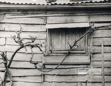
Photograph, George W. Bell, Detail, Front Wall, Birch Cottage, Yarra Glen Road, Smiths Gully, Aug 1969, Aug 1969
... of its location on Crown land. In 2007 the Andrew Ross Museum... of its location on Crown land. In 2007 the Andrew Ross Museum ...EDHS Newsletter No. 182, September 2008 In the late 1970s when our Society was the Shire of Eltham Historical Society, an offer was made to the Society regarding use of an old cottage at Christmas Hills. For various reasons the offer ultimately lapsed The cottage sat beside Watsons Creek just outside the then Shire of Eltham but following municipal restructuring it now lies within the Shire of Nillumbik. At that time some research on the cottage was carried out for the Society by Keith Chappel as part of a larger research project that he was doing. Keith's notes were taken from Lands Department records and showed that house is the subject of a permissive occupancy of Crown land comprising the creek reserve. In 1903 a Miners Right of one acre in area was granted to Edwin Samuel Birch. In 1907 Birch applied to purchase this land but was unable to because it was part of the creek reserve. The documents show that the house existed at that time. Birch died in 1932 and his daughter Honor Mary Birch was granted a permit to occupy the residence. The future of the cottage remains precarious because of its location on Crown land. In 2007 the Andrew Ross Museum began a campaign to ensure that it is preserved. It included a video presentation on the history of the cottage under the title of "This Old House- Birch Cottage". Black and white photographDetail of Front Wall Williams Cottage Yarra Glen Rd Panton Hill Aug 1969 Photo - G.W.Bhouses, cottage, early settlers, yarra glen road, smiths gully, williams cottage, watsons creek, christmas hills, birch cottage, edwin samuel birch, honor mary birch -
 Eltham District Historical Society Inc
Photograph, George W. Bell, Detail, Shed Wall, Birch Cottage, Yarra Glen Road, Smiths Gully, Aug 1969, Aug 1969
... of its location on Crown land. In 2007 the Andrew Ross Museum... of its location on Crown land. In 2007 the Andrew Ross Museum ...EDHS Newsletter No. 182, September 2008 In the late 1970s when our Society was the Shire of Eltham Historical Society, an offer was made to the Society regarding use of an old cottage at Christmas Hills. For various reasons the offer ultimately lapsed The cottage sat beside Watsons Creek just outside the then Shire of Eltham but following municipal restructuring it now lies within the Shire of Nillumbik. At that time some research on the cottage was carried out for the Society by Keith Chappel as part of a larger research project that he was doing. Keith's notes were taken from Lands Department records and showed that house is the subject of a permissive occupancy of Crown land comprising the creek reserve. In 1903 a Miners Right of one acre in area was granted to Edwin Samuel Birch. In 1907 Birch applied to purchase this land but was unable to because it was part of the creek reserve. The documents show that the house existed at that time. Birch died in 1932 and his daughter Honor Mary Birch was granted a permit to occupy the residence. The future of the cottage remains precarious because of its location on Crown land. In 2007 the Andrew Ross Museum began a campaign to ensure that it is preserved. It included a video presentation on the history of the cottage under the title of "This Old House- Birch Cottage". Black and white photographDetail of Shed Wall Williams Cottage Yarra Glen Rd Panton Hill Aug 1969 Photo - G.W.Bhouses, cottage, early settlers, yarra glen road, smiths gully, williams cottage, watsons creek, christmas hills, birch cottage, edwin samuel birch, honor mary birch -
 Eltham District Historical Society Inc
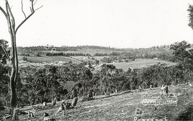
Photograph, Tom Prior, Clearing land at Research
Main Road is in the distance with the aqueduct following the pine trees at top of photo. Doney's store is visible near the road.The Reynolds family were early settlers in Research. The Reynolds/ Prior collection of photographs were taken by Tom Prior, the maternal uncle of Ivy Reynolds, around 1900 and the 60 photos in the album give a fine overview of many of the landmarks of Research and Eltham over 100 years ago. lvy lived in the family home for many years at 106 Thompson Cres Research. Ivy's father, Ernst Richard Reynolds and grandfather, Richard Reynolds, lived at the same address. Ivy's father Richard worked for Mr. Trail on his property in Research. Reynolds Road is named after the family. Mr Tom Prior (wife Eva) worked at the Melbourne zoo. He was very innovative and made his own camera, using the black cloth hood to exclude the light. The photographs are a reminder of the rural nature of Research and Eltham and its rich heritage. Black and white photograph mounted in an album, the Reynolds/Prior Photograph Collection, this being one of 53 reproduced black and white images of early Eltham.The Reynolds/Prior Photograph Collection, Presented to the Eltham District Historical Society, 14 June 2006 by Ross McDonald. A second copy was also presented to the Andrew Ross Museum, Kangaroo Groundreynolds prior collection, research (vic.) -
 Eltham District Historical Society Inc
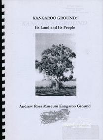
Book, Andrew Ross Museum, Kangaroo Ground: its Land and its People by Mick Woiwod published by Andrew Ross Museum, 2002
Kangaroo Ground's geology, original people, European settlers, plants used by Wurundjeri people26 leaves : ill., maps ; 30 cm.wurundjeri (australian people) -
 Eltham District Historical Society Inc
Photograph, Entrance to Shire of Eltham Memorial Park, Garden Hill, Eltham-Yarra Glen Road, Kangaroo Ground, c.1923
View to south-east from Shire of Eltham Soldiers' Memorial Park showing the carriageway from the road to top of Memorial Park. Accompanying notes state that the entry gate was put in place in May 1921. Eltham and Whittlesea Shire Advertiser and Diamond Creek Valley Advocate Fri 21 May 1920 p 2 reported: Kangaroo Ground Memorial Park "It was decided to arrange for a working bee on Saturday, 29th inst., for the purpose of forming and gravelling the track leading to the Park, and of carrying out other necessary works." A history summary of the Shire of Eltham Soldiers’ Memorial Park • The summit at Garden Hill was a popular tourist lookout and picnic spot from the 1880s. Virtually the entire Shire of Eltham and beyond could be viewed from this location. • A local farmer, Mr Walter A. D. Wippell is credited as being the first to propose the idea of a war memorial park and offered £50 towards the purchase of the land. • The earliest public reference to this project is to be found in the local Advertiser newspaper edition of August 9th, 1918. A report of the August Council meeting records the Eltham Shire President, Cr. Robert White, saying: "some time back it was proposed that the Council obtain and place on an Honour Board in the Council Chamber [at Kangaroo Ground] containing names of the lads who had enlisted. Just recently however, it had been suggested that a more fitting memorial would be the obtaining of a piece of land on the summit of Garden Hill, Kangaroo Ground, and the formation of a memorial park in which a monument could be erected to represent the whole of Shire. If a couple of acres could be obtained a gentleman had promised to donate 50 pounds, and another one would fence it, and other contributions, he was sure, could be obtained." • Councillors were favourable of the proposal and the President, Shire Secretary and Shire Engineer were deputised to wait on Messrs Mess Bros. (the owners of the Garden Hill farm) and ascertain if they would gratuitously give the land. The Mess Bros. land adjoined the farm/stud of Mrs Fanny White (Cr Robert White’s mother), daughter of Andrew Harkness who established their property on Garden Hill around 1846. • Access to the land came in February 1919 when several Councillors and the Shire Engineer surveyed the actual two acres of '5 chains along the road and 4 chains deep'. The Engineer volunteered his services free to do this task. The Mess brothers however demanded £100 per acre but eventually agreed to take £50 per acre. • Entry from the Kangaroo Ground-Yarra Glen road was seen to be a problem and Mrs. White, who owned the land beside the park, was asked to donated a triangle of her property to allow this access. • By September 1919 returned soldiers were employed by the Shire and volunteers were called to clear the hilltop by ploughing up the rocks and clearing the area, the fencing was put into place and in May 1921 the Council erected three gates, within an archway, at the entrance to the drive and pathway to the summit. • Public subscriptions were sought through the Advertiser newspaper to beautify the site. The views of the Curator of the Melbourne Botanical Gardens were sought as to the ‘class of ornamental trees most suitable for planting in the Park area”. • The Memorial Park or Shire of Eltham Soldiers’ Memorial Park was officially opened by Mr. W.H. Everard, M.L.A., 3 September 1921. • In 1922 plans were made to place a War Memorial in the Park. Funds were donated by the Council of £250 and a challenge to the community, to match this money with contributions was met. • On Anzac Day 1923, 1,000 people gathered on the summit in the park for a memorial service. A much smaller group of about 50 people gathered around a newly constructed cairn and flagstaff in the afternoon of Anzac Day 1924 amidst rain and a squally southerly wind, the morning service being cancelled. • A meeting for those interested in establishing a War Memorial monument within the park was held in January 1924 and the Eltham Shire War Memorial League was formed and a design competition decided upon. • The Shire of Eltham War Memorial tower was built in 1926 at a cost of £1,023 and 5 shillings with locally quarried stone donated by Dr Ethel and Professor William Osborne. It was formally known as the ‘Shire of Eltham War Memorial’ and was unveiled on 11 November 1926. The large bronze inscription above the entrance to the tower states: SHIRE OF ELTHAM WAR MEMORIAL THESE MEN DIED FOR THEIR COUNTRY 1914 IN REMEMBRANCE THIS TOWER WAS BUILT 1918 • The Caretaker’s hut was built in 1927 with left over from the tower construction. • A returned soldier was appointed to act as caretaker for the memorials. Tiny Carrol, a huge man, was the first caretaker and lived in the stone hut. There was a push to have alterations made at one stage to provide additional rooms for a married caretaker but was rejected. • A new Caretaker Cottage was built in 1951 at a cost £2,500. The cottage had been subjected to raids by thieves three times during construction until a guard from the Returned Servicemen’s League was posted until its opening. • The War Memorial tower was re-dedicated by Sir Dallas Brooks on 8 November 1951, unveiling new bronze plaques containing the names of those who fell during the Second World War. Sir Dallas also officiated the opening of the new Caretaker’s Cottage. • A toilet block was built in 1965. • A further dedication of the Shire of Eltham War Memorial tower took place 11 November 2001 to recognise the men who fell in subsequent campaigns up to and including Vietnam. • Four land titles are involved: o The purchase of the two acres from owners Ruth Gosling, Alexander Mess, James Johnson Mess and Joseph Mess is recorded in two actions, the first being the payment of £100 for the two acres, the second showing that the Shire of Eltham did not get a transfer of title until 14th January 1952. o The access land donated by Mrs. Fanny White is dated 26 February 1924. A further need to widen the entry came after the deepening of the road cutting and another land donation was given by Sir Herbert Gepp, title dated 15th May 1952. This would have been about the time he sold off the former White ‘Garden Hill’ property. o The land reserve to increase the area and possibly allow a circuit road to be put in place on the western side of the park was purchased by the Shire of Eltham, title dated 16th February 1973. Rare photograph of the entrance to the Shire's Memorial Park during early stages of development prior to the erection of the Shire of Eltham War MemorialSepia photograph printed with white border with slight crack lower left hand corner and three significant vertical cracks fanning from lower centre edge to upper edge Digitally enhanced version to minimise impact of crackseltham-yarra glen road, entrance gate, garden hill, kangaroo ground, shire of eltham memorial park, shire of eltham war memorial, kangaroo ground war memorial park -
 Eltham District Historical Society Inc
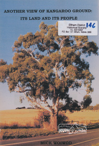
Book, Mick Woiwod, Another view of Kangaroo Ground : its land & its people / Mick Woiwod, 2009
Paperback; 54 p. : ill. (some col.), maps, port ; 30 cm.Inscribed and signed by Author wurundjeri, social customs, place names, yarra river, environment, kangaroo ground, culture, aborigines -
 Eltham District Historical Society Inc
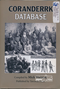
Book, Tarcoola Press, Coranderrk Database compiled by Mick Woiwod, 2012
Database of information on Coranderrk 1835 to 1995.Winner of the Local History Project Award (for activities that enhance access to records of significance to local communities) as part of the Victorian Community History Awards 2012 242 pages : illustrations ; 30 cm + 1 CD-ROM (4 3/4 in.) PDF, Word files.ISBN 9780987157416green, john., bon, anne fraser, 1838-1936., coranderrk aboriginal station. -
 Eltham District Historical Society Inc
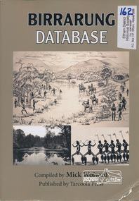
Book, Tarcoola Press, Birrarung Database compiled by Mick Woiwod, 2012
Sister publication to "Coranderrk database". This is a compilation of Mick Woiwod's research material, gathered over many years with information on the history of the Wurundjeri people of the Yarra Valley, from the time of first European contact. The publication runs in excess of 140,000 words. Its prime focus is the Yarra River as it has been understood by its Wurundjeri people. Includes a compilation of those difficult to locate "brief snatches of the action" collated under headings with in each instance, the provenance as to source and / or author included. Themes include: agriculture, law, ceremony, language, reconciliation, retribution, lifestyle, art & craft, climate, personalities, disease, death and the river's flora and fauna.318 pages : illustrations, maps ; 30 cm + 1 CD-ROM (4 3/4 in.) PDF or Microsoft Office Word 97-2003.ISBN 9780987157423wurundjeri, yarra river, indigenous history -
 Eltham District Historical Society Inc
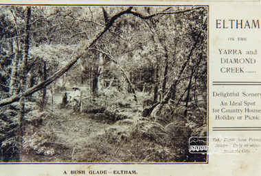
Photograph, A bush glade Eltham, c.1909, 1909c
Colour photograph from land sales brochure showing a bush glade Eltham c1909 sent to Mrs Andrewbush glade, eltham, bushland -
 Warrnambool and District Historical Society Inc.
Documents, William Ardlie Archives, C 1900-1940
This collection of papers have come from the offices of William Ardlie a local solicitor. He was born in Moonee Ponds in 1843 and was admitted as an attorney and solicitor of the supreme Court in 1865. From 1867 to 1878 he was in partnership with George Barber and then continued to practise until his late eighties which made him the oldest practising lawyer in Australia. He was involved in local councils and organisations such as the Hospital and Anglican Church.He was associated with several large homes in Warrnambool including Wyton presently the home of Emmanual College Warrnambool. He died in 1933.His son E L Ardlie also practised as a solicitor from the same offices from 1893. A number of the invoices included relate to the Estate of James drought who was a local policeman and owner of a number of properties and operated in various trades such as George Ramsay manufacturer of stoves and chimneys, J Rogers plumber & gas fitter and Christian & Dodds who were carpenters and joiners. There are a number of documents which relate to the Chinese, many of whom operated market gardens along the Merri River. They were a familiar part of Warrnambool from around 1872 until around 1940. The names mentioned in these documents include Ah Foo,Charles Quing Bow, Andrew Quing Bow Ah Bing Ah Jing Ah Moon and Ah Seong. They were reknown for their supply of fresh vegetables to the people of the town. They leased land from John Moore. These documents are a cross section of the types of documents which were used and are still used in the operation of businesses. They provide a social snapshot of people and the business which they conducted with their solicitors in this case William and E L Ardlie who were a long standing legal firm in the district. Another interesting aspect of some of these documents is the leases signed by the Chinese market gardeners who played an important but often overlooked aspect of Warrnambool's aspect.A total of 27 documents which relate to William Ardlie Solicitors 001133.1Policy from The Victoria Insurance Company for office effects, 001133.1.2 Receipt for 11/1 for policy. 001133.2 Renewal Receipt from Messrs Hammond & Richards as agents for Victoria Insurance Co. 001133.3 Renewal Receipt from Messrs Hammond & Richards as agents for Victoria Insurance Co. 001133.4 General rates receipt . City of Warrnmbool. 001133.5 Water rates receipt . City of Warrnmbool. 001133.6 Camperdown Chronicle , Letter re overdue payment 001133.7 Camperdown Chronicle Statement 31/12/1948 001133.8 Transfer of land notice Ben Rogers Mepunga 001133.9 W H Philpott Account for rent Estate R P Thomas 001133.10 George Ramsay account for Mr Walters for stove setting. 001133.11 Archibald Macfarlane & Co account for Estate James Drought for advertising. 001133.12 Letter to E L Ardlie re deed of Keane family arrangements 21/10/1910 001133.13 Letter to E L Ardlie re charges of Keane Estate 14/12/1910 001133.14 Account to E L Ardlie from J Rogers re estate Mr Drought , repairs.1/08/1906 001133.15 Account to EL Ardlie from J Rogers re estate Mr Drought1/10/1907 001133.16 Account to William Ardlie from J Rogers re estate Mr Drought 01/07/1908 001133.17 Account to William Ardlie from J Rogers re estate Mr Drought 01/07/1908 001133.18 State Savings Bank Victoria passbook of Margaret Molan 1/02/1937 001133.19 Account to E L Ardlie from Christian & Dodds repairs to Droughts house 01/07/1905 001133.20 Account to E L Ardlie from Christian & Dodds for Estate of Drought for house repairs Darling St1/10/1905 001133.21 Estimate to A A Briggs from Christian & Dodds for Estate of Drought 06/04/1908 001133.22 Receipt to E L Ardlie from Christian & Dodds for Estate of Drought for house repairs 01/05/1906 001133.23 Lease Indenture 02/06/1922 between William Ardlie andAH Foo re Crown Allotment 144 Wangoom for 70 pounds. 001133.24 Agreement 18/06/1929 Messrs Quing Bow & Sons to Messrs Ah Bing Ah Jing Ah Moon and Ah Seong witnessed John Moore. 001133.25 Lease indenture made 18/06/1929 betweenWilliam Ardlie to messrs Ah Bing Ah Jing Ah Moon and Ah Seong. 001133.26 Agreement 18/06/1929 Messrs Quing Bow & Sons to Messrs Ah Bing Ah Jing Ah Moon and Ah Seong witnessed John Moore 001133.27.1 Notification to Creditor of issue of stay order farmers Debts adjustment Act 1935 to Ellen C McGinness and Estate of john McGinness 001133.27.2Note re monthly inst of interest Estate McGinness1942 001133.27.3 Estate of j A Bromfield re Estate of McGinness Arrears of Interest1943 001133.27.4 Letter to W Ardlie from The Trustees Executors & Agency Co Ltd24/02/1944 re interest on J A Bromfield's trust re McGinness mortgage. 001133.27.5 Letter to W Ardlie from The Trustees Executors & Agency Co Ltd 25/02/1944 re interest on J A Bromfield's trust re McGinness mortgage. 001133.27.6 William Ardlie to The Trustees Executors & Agency Co Ltd re Bromfield & McGinness 24/02/1944 001133.27.7 The Trustees Executors & Agency Co Ltd to William Ardlie re receipts 16/03/1944 001133.27.8 The Trustees Executors & Agency Co Ltd to William Ardlie re Bromfield & McGinness18/03/1944 Unable to complete enquiries. 001133.27.9 The Trustees Executors & Agency Co Ltd to William Ardlie 27/03/1944 001133.27.10 The Trustees Executors & Agency Co Ltd to William Ardlie29/04/1944 001133.27.11 Estate Sarah Donaldson re accrued Interest 1933-1961 001133.28.1 Indenture between Emily Maria Briggs,Mary Jane Briggs, Frederick William Briggs, Fanny Alethea Briggs, James Alfred Briggs,Lucy Annie Briggs, Arthur Albert Briggs , and Mary Ann Briggs 001133.28.2 Letter re estate of Mary Ann Briggs 001133.1 No 590911 001133.1.2 Signed G Begley 001133.2 Hammond & Richards 43/5 Kepler St Warrnambool 001133.3 Hammond & Richards 43/5 Kepler St Warrnambool 03/03/1934 001133.4 W Ardlie 18/06/1929 Thomas Beattie collector 001133.5 W Ardlie 18/06/1929 Thomas Beattie collector 001133.6 Wm Ardlie signed W A Donald10/08/1949 001133.7 Wm Ardlie 31/12/1948 001133.8 Alexander Ben Rogers 26/05/1950 001133.9 Estate R P Thomas 28/061955. Phone 124 001133.10 .Mr Walters Drought A Ramsay 01/05/1906 001133.11 Estate of the late James Drought 24/05/1906 001133.12 W F Molesworth Re Thomas Keane. Phone 81. 21/10/1910 001133.13 W F Molesworth Phone 81 Thomas Keane14/12/1910 001133.14 E L Ardlie Joseph Rogers 13/08/1906 001133.15 E L Ardlie Joseph Rogers 01/10/1907 001133.16 E L Ardlie 01/07/1908 001133.17 Estate Late Mr Drought 01/07/1908 001133.18 Miss Margaret Molan 001133.29 L Ardlie 01/07/1905 001133.20 E L Ardlie 01/10/1905 001133.21 Mr A A Briggs Christian & Dodds 06/04/1908 001133.22 L Ardlie W Christian 01/05/1906 001133.23 Stamp duty 04/061926 Signed William Ardlie Est Conway Ah Foo 001133.24 Signed John Moore, Charles Quing Bow, Andrew Quing Bow, Ah Bing, Ah Jing, Ah Moon, Ah Seong. 001133.25 Signed William Ardlie, E H Conway, Ah Bing, Ah Jing, Ah Moon, Ah Seong, John Moore. 001133.26 Signed John Moore, Charles Quing Bow, Andrew Quing Bow, Ah Bing, Ah Jing, Ah Moon, Ah Seong. 001133.27.1 Ellen C McGinness and Estate of John McGinness James Dickson R R Macfarlane Richard Vincent McGinness, Abraham McGinness, John Ambrose McGinness 14/07/1936 001133.27.2 Note re monthly inst of interest Estate McGinness 1942 001133.27.3 J A Bromfield McGinness 001133.27.4 W Ardlie, The Trustees Executors & Agency Co Ltd 24/02/1944 J A Bromfield's trust re McGinness mortgage. Syd Jackson 001133.27.5 W Ardlie ,The Trustees Executors & Agency Co Ltd 25/02/1944 J A Bromfield's trust re McGinness mortgage.Syd Jackson 001133.27.6 William Ardlie The Trustees Executors & Agency Co Ltd re Bromfield & McGinness 24/02/1944 001133.27.7 The Trustees Executors & Agency Co Ltd William Ardlie 16/03/1944 001133.27.8 The Trustees Executors & Agency Co Ltd William Ardlie Bromfield & McGinness 18/03/1944 001133.27.9 The Trustees Executors & Agency Co Ltd William Ardlie 27/03/1944 001133.27.10 The Trustees Executors & Agency Co Ltd William Ardlie 29/04/1944 001133.27.11 Estate Sarah Donaldson 1933-1961 001133.28.1 Miss Emily m Briggs to Mrs Mary Ann Briggs Assignment . Stamped William Ardlie Solicitor Warrnambool. warrnambool,, william ardlie, james drought, christian & dodds, chinese of warrnambool, james a bromfield -
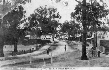 Eltham District Historical Society Inc
Negative - Photograph, Rose Stereograph Company, The Main Strteet, Eltham, Vic, c.1923
The Rose Series P. 4344 postcard. Similar view to SEPP_0609 taken from near Dudley Street looking north but significantly later in time with numerous stores now constructed on the eastern side south of Pryor Street in what was once Haley's Paddock. Luther Haley sold his bakery store in 1917 and the roof now sports advertising signage for Electrine Candles, presumably coincident with the period of ownership by Hannah Lloyd from 1917 to about February 1920 or Lee’s Railway Store (Messrs J.R. & N.E. Lee 1920-Sep 1922). A boy and a man are standing in the road and the ghost image of three people walking towards them on the footpath just past the store. Ernie Andrew’s combined newsagency and haberdashery/clothing shop with advertising for "The Age" is present at the corner of Arthur Street, on the opposite corner would be the Bootmaker's shop (F. Butterworth, succeeded in 1922 by G.H. McDonald) and William J. Capewell's Butcher shop, second building from right (relocated from in front of the railway station in 1910). North of the News Agency is believed to be Horace H. Clark’s Land and Estate Agency which had also relocated across the road.This photo forms part of a collection of photographs gathered by the Shire of Eltham for their centenary project book,"Pioneers and Painters: 100 years of the Shire of Eltham" by Alan Marshall (1971). The collection of over 500 images is held in partnership between Eltham District Historical Society and Yarra Plenty Regional Library (Eltham Library) and is now formally known as the 'The Shire of Eltham Pioneers Photograph Collection.' It is significant in being the first community sourced collection representing the places and people of the Shire's first one hundred years.Digital image 120 format B&W negative (copy of original postcard)shire of eltham pioneers photograph collection, eltham, main road, bootmakers, butcher, dudley street, electrine candles, eltham town centre, hannah lloyd, lloyd's general store, newsagency, pryor street, rose series postcard, shops, william james capewell, ernie andrew, f. butterworth, g.h. mcdonald, haley's paddock, j.r. lee, lee's railway store, n.e. lee, rose stereograph company -
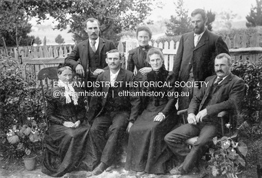 Eltham District Historical Society Inc
Photograph, Gulf Station, Yarra Glen. Members of the Bell Family, 1905c
Mrs Bell and her adult children of Gulf Station, Yarra Glen. Standing Jack (John), Jemima, Andrew. Seated Mary Ann (mother of all the others), Frank (Francis), Dinah and Bill (William). Scottish settlers Agnes and William Bell were the first to lease the land where the property was established in the 1850s. Gulf Station was farmed for nearly 100 years by the Bell family.This photo forms part of a collection of photographs gathered by the Shire of Eltham for their centenary project book,"Pioneers and Painters: 100 years of the Shire of Eltham" by Alan Marshall (1971). The collection of over 500 images is held in partnership between Eltham District Historical Society and Yarra Plenty Regional Library (Eltham Library) and is now formally known as 'The Shire of Eltham Pioneers Photograph Collection.' It is significant in being the first community sourced collection representing the places and people of the Shire's first one hundred years.Digital imagesepp, shire of eltham pioneers photograph collection, yarra glen, bell family, gulf station, dianah bell, frank bell, jack bell, jimima bell, mary ann bell, william bell -
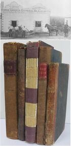 Ringwood and District Historical Society
Book - Business Records, Collection of 5 Day-books and Ledgers kept by Thomas Grant, Blacksmith, Ringwood, Victoria
GRANT, Thomas (From Short Notes on Ringwood - RDHS) Born 1854, died 1933, aged 79 years. Thomas Grant, born in Burwood, Victoria, came to Ringwood in 1876. On land purchased from Mr. D. Gostick in Whitehorse Road, in the vicinity of the present Drive In Arcade, he built a blacksmith's and coach building shop. In 1880, he married Mary Ann French, of Mulgrave. There were four children, Andrew, Mary, (died in infancy) Thomas, and Margaret. Miss Margaret Grant is a well known resident of Mullum Road. With the opening of the station in 1882, activities in the growing district tended to congregate in its vicinity, and, in 1883, Mr. Grant moved his “smith" to the corner of Adelaide Street. At the same time, he planted out an orchard on his land which ran from Ringwood Street, to Warrandyte Road, and north as far as Mullum Greek. Eventually, about 1910, he sold his business to the Reed Brothers, and retired to the comparatively lighter life of orchardist and market gardener. In 1909, he sold 8 acres of his land to the Lilydale Council. This land, situated in Ringwood Street, behind the Town Hall, is known as the Ringwood Reserve. Mr. & Mrs. Grant were foundation members of the Methodist Church. He was appointed a Trustee in 1879, and served until his death 54 years later. He was an enthusiastic member of many societies, and he held public office in civic affairs. His interests included the Progress Association, Cricket Club, and the Agricultural Society, at whose annual show, he was a regular exhibitor. He served as a Councillor in the Lilydale Shire, repres¬enting Ringwood, from 1889 to 1894, and was a Justice of the Peace. 26278a Ledger belonging to First Blacksmith in Ringwood 1880s. Dark green cover with leather spine and corners. Dark coloured edges on pages. 542 pages, 320 used. 26278b Day book belonging to Thomas Grant, Blacksmith, Ringwood used 1929. Brown covered book with leather spine. First 95 pages torn out. Only two pages of remaining 76 used. 26278c Ledger with alphabetical index - Thomas Grant, Blacksmith, Ringwood - 1888. Green covered book with red spine and corners. Dark coloured edges on pages. 275 pages. Some unused. 26278d T. Grant Blacksmith Day Book. Green covered day book of T. Grant, Blacksmith and General Smithy, Ringwood 1883 . Red square on spine with Day book written on it. Day Book in ink hand written on front spine. 26278e Day book belonging to Thomas Grant, Blacksmith, Ringwood - 1879-1881. Green cover with brown spine and edges. Gold lettering on spine saying Day Book Pages all used. 26278f Collection of receipts, some blotting paper, some pages from the Journal of Architecture, a short story, and drawing with description of an Albert Sociable carriage. -
 Ringwood and District Historical Society
Photograph, View from Loughnan Rd. looking south east over Harrison Street/Andrew Street corner, c.1949
Black and white photograph showing some vacant land and new houses under construction. Developed area in background. (3 copies)Typed below photograph, "View from Loughnan Rd. looking south east, 1949". Written on backing sheet, "View from Loughnan Rd. to corner Harrison and Andrew Street, c1949". -
 Glen Eira Historical Society
Album - Album page, Nithsdale now Five Way Hill, Kambrook Road, Circa 1972
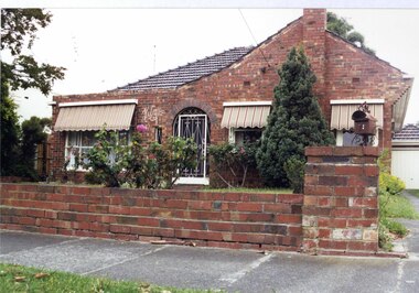
This photograph is part of the Caulfield Historical Album 1972. This album was created in approximately 1972 as part of a project by the Caulfield Historical Society to assist in identifying buildings worthy of preservation. The album is related to a Survey the Caulfield Historical Society developed in collaboration with the National Trust of Australia (Victoria) and Caulfield City Council to identify historic buildings within the City of Caulfield that warranted the protection of a National Trust Classification. Principal photographer thought to be Trevor Hart, member of Caulfield Historical Society. Most photographs were taken between 1966-1972 with a small number of photographs being older and from unknown sources. All photographs are black and white except where stated, with 386 photographs over 198 pages. Glen Eira Heritage Management Plan (1996) by Andrew Ward and Associates - Vol 3 "Nithsdale", built for J.S. Crouchin 1858 and extended in 1885 with a tower and associated rooms, survives as testimony to the nineteenth century occupation of the vicinity of the Kambrook/Glen Eira Road intersection. Caulfield's Building Heritage by Dr Geulah Solomon, Vol 1 p49 records it as a small Victorian mansion home on bluestone foundations of Italianate style with a tower. Built for J S Chambers circa 1860, it was built in stages and then the land subdivided in the 1920s. Other owners include Adolph F Brockhoff (of Brockhoff Biscuits company). Names used besides Nithsdale have been Bundoora and Five Way Hill. Page 102 of Photograph Album with four photographs (three landscape and one portrait) of Nithsdale, now known as Five Way Hill. Three views of the tower and one of the house.Handwritten: "Nithsdale" now "Five Way Hill" Kambrook road [top right] / CNR KAMBROOK AND GLENEIRA ROADS [under bottom right photo] / 102 [bottom right]trevor hart, north caulfield, victorian, mid victorian, late victorian, tower, j.s. crouchin, 1850's, 1880's, italianate, rendered, five way hill, nithsdale, slate roof, plaster arches, ornamental columns, triangular pediment, ornamental parapet, cast iron balconies, kambrook road, glen eira road, t crouch, j s crouchin, mansions, j s chambers, bluestone foundations, land subdivision, adolph f brockhoff, bundoora, house names -
 Glen Eira Historical Society
Album - Album page, Bureel (Kooyong Road), Circa 1972
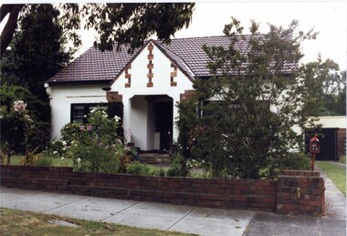
This photograph is part of the Caulfield Historical Album 1972. This album was created in approximately 1972 as part of a project by the Caulfield Historical Society to assist in identifying buildings worthy of preservation. The album is related to a Survey the Caulfield Historical Society developed in collaboration with the National Trust of Australia (Victoria) and Caulfield City Council to identify historic buildings within the City of Caulfield that warranted the protection of a National Trust Classification. Principal photographer thought to be Trevor Hart, member of Caulfield Historical Society. Most photographs were taken between 1966-1972 with a small number of photographs being older and from unknown sources. All photographs are black and white except where stated, with 386 photographs over 198 pages. From: Glen Eira Heritage Management Plan 1996 by Andrew Ward In 1856, John Allee, a builder from Brighton, purchased C.A. 37 on the south-west corner of Glenhuntly and Kooyong Roads. The land comprised just over 45 acres. By 1863, Francis John Sidney Stephen, a lawyer and cousin of J. Wilberforce Stephen, owned most of lot 37. By 1866, Stephen had a built a "small mansion" named ''Burreel". It was a brick house and Stephen lived there until 1882. By 1884, Mrs Buxton of Hillside Terrace, East Melbourne, had purchased the property. Richard Buxton, a gentleman was listed as occupant and the house described as "brick, eight rooms". NAV was £300. Richard Buxton continued residency in 1887 however in 1888, George Allen, music seller, became occupant. At that time the house had thirteen rooms on twenty-three acres of land. Twelve people lived there and NAV was £920. In 1900, Daniel Luxton, stock and sharebroker and the Honourable John Taverner, M.H.A. leased the property. Fourteen people lived there. Mrs Buxton continued as owner. By 1910, ownership had passed to Mrs Mary Neate, who converted the house to a nursing home. The land had been subdivided by 1913 and sold by ''Buxtons Estate". Burreel Avenue, Baxter, Buxton and Hoddle Streets were created. "Burreel" was rated to Burreel Avenue and stood on lot 13 with frontages to Burreel Avenue and Kooyong Road of 198' and 214'. The house had ten rooms. NAV was £60. Mary Neate, a nurse, continued as owner/ operator of ''Burreel" nursing home in 1927. At that time there were sixteen rooms and fourteen residents. NAV was £100. Mrs Neat remained there until 1947. In 1948, the house was turned into apartments. In the 1980's, the Alexander family purchased it and restored it to a private residence.Burreel 331 Kooyong Road, ELSTERNWICK VIC 3185 - Property No B4950 National Trust https://vhd.heritagecouncil.vic.gov.au/places/65648 This is a large and substantially intact example of the grand villas of nineteenth century Melbourne. The bulk of the house most probably was built in 1866-1868 for Francis John Sidney Stephen, a prominent and highly regarded Melbourne solicitor and a member of an illustrious legal family. Stephen conducted a lucrative private practice and in 1845 was appointed first solicitor to the City of Melbourne; a position he held until his death in 1895. He took an active part in the development of Caulfield and was Shire President in 1874 and 1877. He was a resident at Burreel from 1868 to 1882. The house has evolved in stages, the rear wings possibly remaining from a house built during the 1850s. The existing ornate cast iron verandah was probably built between 1882 and 1888 during the residence of Richard Buckhurst Buxted, a notable boom period auctioneer and real estate agent. George Allan, the founder of Allan's music store, was another important occupier from 1888 to 1991. Bureel's essentially residential quality has been retained and the interior has been well preserved. The significance of this building does not rest in any single unusual outstanding architectural feature, or in its association with a particularly prominent member of society in the past, but rather in the consistent integrity of both the interior and exterior, which results in the survival of an outstanding example of this type of residential building and its associations with two notable citizens. Classified:11/08/1990Page 113 of photograph album with 1 photograph of Burreel in its garden.Handwritten: Bureel [top left] / 113 [bottom left]trevor hart, caulfield, caulfield north, kooyong road, thomas king, mansion, 1860's, bureel, burreel, francis john sidney stephen, city of melbourne, shire president, 1850's, verandah, nursing home, john allee, ornamented corner stones, new orleans manner, plaster rendered, mrs luxton, vincent willis, alexander family, victorian architectural style, ornate cast iron work, lawyers, brick houses, richard buxton, richard buckhurst buxton, george allen, george leavis allan, allans music, daniel luxton, john taverner, mary neate, buxtons estate, land subdivision, mary neat, gardens -
 Glen Eira Historical Society
Photograph, Beauville Avenue, 28, Murrumbeena, 2001
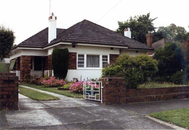
Originally labelled "Beauville Estate, Established 1936, Still Thriving 65 years on, 10th March 2001", the Beauville Estate Album contains colour photographs of houses in the Estate. They were taken around the time of the Beauville Estate’s 65th Heritage Celebration held on 10/03/2001 and donated to the Caulfield Historical Society shortly afterwards. Photographer unknown.City of Glen Eira’s Heritage Management Plan Vol 2 p79 (this is p84 of the pdf version) – HO12 Beauville Estate and environs, Murrumbeena: The Beauville Historic Area is important at the State level as the first large housing estate undertaken by the AV Jennings Construction Co, later Jennings Group Limited, Victoria’s largest home builder. It is important also as a very early estate development incorporating a range of features other than houses and including made roads, shops and recreation facilities. In this respect it was the forerunner of the comprehensively planned housing estate of the post war era. The estate is distinguished by its aesthetic values, as is the earlier and comparable Hillcrest Estate, which are formed by a combination of restrained diversity in house styles, with the exception of no. 30 in the emerging International style, and by a landscaped garden environment. See Significance Statement in Glen Eira’s Heritage Management Plan by Andrew Ward (1996) Vol 2 p.79. Available from https://www.gleneira.vic.gov.au/media/4779/heritage_management_plan_volume_2.pdf (Note see p.84 of pdf)Colour photograph of unpainted variegated brown brick house with "Kileen 28" in cast iron on the front wall. Other features include a porch with white cast iron work door, tiled roof, chimney, striped window awnings and low unpainted brick fence with a brown metal letterbox in the foreground beside the driveway. The house has an unusual pitched roof with timber eave on the right side of the house.Kileen / 28murrumbeena, houses, beauville avenue, architectural styles, 1930's, inter war style, a.v. jennings, av jennings, jennings, brick houses, beauville estate, porches, arches, letterboxes, sir albert victor jennings, a v jennings construction co, beauville estate heritage area, glen eira city council, architectural features, jennings group limited, land subdivision, gardens, beauville historic area, cast iron work, house names, kileen, brick features, brick chimneys, striped awnings, brick fences, metal letterboxes, roofs -
 Glen Eira Historical Society
Photograph, Beauville Avenue, 35, Murrumbeena, 2001
Originally labelled "Beauville Estate, Established 1936, Still Thriving 65 years on, 10th March 2001", the Beauville Estate Album contains colour photographs of houses in the Estate. They were taken around the time of the Beauville Estate’s 65th Heritage Celebration held on 10/03/2001 and donated to the Caulfield Historical Society shortly afterwards. Photographer unknown. Windows frames, gutters and drain pipe all painted black but this is same property as 2104A-39 where they are painted green.City of Glen Eira’s Heritage Management Plan Vol 2 p79 (this is p84 of the pdf version) – HO12 Beauville Estate and environs, Murrumbeena: The Beauville Historic Area is important at the State level as the first large housing estate undertaken by the AV Jennings Construction Co, later Jennings Group Limited, Victoria’s largest home builder. It is important also as a very early estate development incorporating a range of features other than houses and including made roads, shops and recreation facilities. In this respect it was the forerunner of the comprehensively planned housing estate of the post war era. The estate is distinguished by its aesthetic values, as is the earlier and comparable Hillcrest Estate, which are formed by a combination of restrained diversity in house styles, with the exception of no. 30 in the emerging International style, and by a landscaped garden environment. See Significance Statement in Glen Eira’s Heritage Management Plan by Andrew Ward (1996) Vol 2 p.79. Available from https://www.gleneira.vic.gov.au/media/4779/heritage_management_plan_volume_2.pdf (Note see p.84 of pdf)Colour photograph of white rendered house with unpainted variegated brown brick features including a geometric pattern of 3 vertical shapes on the gable over the porch. Other features include a wide arched porch, tiled roof and low unpainted brown brick fence in the foreground with "35" on the reddish brown metal letterbox on top of the brick pillar beside the driveway. Garage has a matching brown brick feature wall.murrumbeena, houses, beauville avenue, architectural styles, 1930's, inter war style, a.v. jennings, av jennings, jennings, brick houses, beauville estate, porches, letterboxes, sir albert victor jennings, a v jennings construction co, beauville estate heritage area, glen eira city council, architectural features, jennings group limited, land subdivision, gardens, beauville historic area, rendered houses, brick features, arches, brick fences, garages (private), gables -
 Glen Eira Historical Society
Photograph, Beauville Avenue, 37, Murrumbeena, 2001
Originally labelled "Beauville Estate, Established 1936, Still Thriving 65 years on, 10th March 2001", the Beauville Estate Album contains colour photographs of houses in the Estate. They were taken around the time of the Beauville Estate’s 65th Heritage Celebration held on 10/03/2001 and donated to the Caulfield Historical Society shortly afterwards. Photographer unknown.City of Glen Eira’s Heritage Management Plan Vol 2 p79 (this is p84 of the pdf version) – HO12 Beauville Estate and environs, Murrumbeena: The Beauville Historic Area is important at the State level as the first large housing estate undertaken by the AV Jennings Construction Co, later Jennings Group Limited, Victoria’s largest home builder. It is important also as a very early estate development incorporating a range of features other than houses and including made roads, shops and recreation facilities. In this respect it was the forerunner of the comprehensively planned housing estate of the post war era. The estate is distinguished by its aesthetic values, as is the earlier and comparable Hillcrest Estate, which are formed by a combination of restrained diversity in house styles, with the exception of no. 30 in the emerging International style, and by a landscaped garden environment. See Significance Statement in Glen Eira’s Heritage Management Plan by Andrew Ward (1996) Vol 2 p.79. Available from https://www.gleneira.vic.gov.au/media/4779/heritage_management_plan_volume_2.pdf (Note see p.84 of pdf)Colour photograph of white rendered house with unpainted variegated brown brick features including a wide brick band around the house. Other features include an open porch with brick pillar, striped awning on side windows, tiled roof, chimneys with identical brick features and low unpainted matching brick fence in the foreground with "37" on the brick pillar and white cast iron gate beside the driveway.murrumbeena, houses, beauville avenue, architectural styles, 1930's, inter war style, a.v. jennings, av jennings, jennings, brick houses, beauville estate, porches, sir albert victor jennings, a v jennings construction co, beauville estate heritage area, glen eira city council, architectural features, jennings group limited, land subdivision, gardens, beauville historic area, rendered houses, brick features, striped awnings, chimneys, brick fences, cast iron gates -
 Glen Eira Historical Society
Photograph, Dalny Road, 5-17 Rear, Murrumbeena, 2001
Originally labelled "Beauville Estate, Established 1936, Still Thriving 65 years on, 10th March 2001", the Beauville Estate Album contains colour photographs of houses in the Estate. They were taken around the time of the Beauville Estate’s 65th Heritage Celebration held on 10/03/2001 and donated to the Caulfield Historical Society shortly afterwards. Photographer unknown. From Glen Eira’s Heritage Management Plan by Andrew Ward (1996) Vol 2 p78: "Beauville Avenue is unusual in that it is terminated in a cul-de-sac (see Section 3.9.2) whilst the design of the estate may well be unique for its time in that the houses back onto 6 tennis courts for public use. St. Patrick's Church, which adjoins the estate is a comparatively recent structure whilst the school has one building erected in 1930 and prior to the release of the Beauville lots." It also notes that St.Patrick's Church and School now run the tennis courts. The Beauville Historic Area is important at the State level as the first large housing estate undertaken by the AV Jennings Construction Co, later Jennings Group Limited, Victoria’s largest home builder. It is important also as a very early estate development incorporating a range of features other than houses and including made roads, shops and recreation facilities. In this respect it was the forerunner of the comprehensively planned housing estate of the post war era. The estate is distinguished by its aesthetic values, as is the earlier and comparable Hillcrest Estate, which are formed by a combination of restrained diversity in house styles, with the exception of no. 30 in the emerging International style, and by a landscaped garden environment. See Significance Statement in Glen Eira’s Heritage Management Plan by Andrew Ward (1996) Vol 2 p.79. Available from https://www.gleneira.vic.gov.au/media/4779/heritage_management_plan_volume_2.pdf (Note see p.84 of pdf)Colour photograph of a playground on the Beauville Estate. murrumbeena, houses, 1930's, a.v. jennings, av jennings, jennings, beauville estate, playgrounds, parks and reserves, sir albert victor jennings, a v jennings construction co, beauville estate heritage area, glen eira city council, jennings group limited, land subdivision, gardens, beauville historic area, st patrick's church, st patrick's school, dalny road