Showing 381 items matching "australian army operations"
-
 Bendigo Military Museum
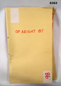
Administrative record - Royal Australian Survey Corps Report on Operation Aright 87 conducted by 1 Field Survey Squadron 1987, 1 Fd Svy Sqn, 26 Aug 1987
1 Fd Svy Sqn in conjunction with 2 Fd Svy Sqn conducted Operation Aright 87 in the Cape York Peninsula area over the period 8 May - 18 Jun 1987. The aim of the Survey Operation was to field verify the 70 x 1:50,000 map sheets which comprised the area of operations. This report details the activities conducted and the results achieved. Manilla Folder with title "OP ARIGHT 1987" containing a paper report of typed pages and diagrams bound together with an ARNOS fastener."OP ARIGHT 87" on front coverroyal australian survey corps, rasvy, fortuna, army survey regiment, army svy regt, asr -
 Bendigo Military Museum
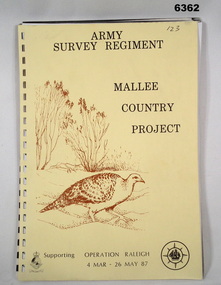
Administrative record - Army Survey Regiment - Malee Country Project 4 Mar - 26 May 1987, Army Survey Regiment, Bendigo, 30 Jun 1987
Project Mallee Country was support provided to Operation Raleigh by members of the Army Survey Regiment during the period 4 Mar - 26 May 1987. This is the report on their activities. Colonel John Blashford-Snell and Prince Charles launched Operation Drake in 1978, running youth projects from ships circumnavigating the globe, to develop self-confidence and leadership through adventure, scientific exploration and community service. In two years 414 young people took part in the round the world voyage, working on land-based projects in 16 countries. Following the success of Operation Drake, the much more ambitious Operation Raleigh was established in 1984, and ran for five years until 1989. The success of Operation Raleigh saw it continue on a permanent basis in 1988, with an emphasis on land-based expeditions.A4 Report, beige coloured cover, brown motif of Mallee Fowl, containing typed paper pages, poor quality photocopied photos and diagrams, unbound.royal australian survey corps, rasvy, fortuna, army survey regiment, army svy regt, asr -
 Bendigo Military Museum
Photograph - Johnson Ground Elevation Meter (JGEM) Survey Vehicle - Army Survey Regiment, Fortuna, Bendigo, c1960s
This is a set of 16 photograph of the Royal Australian Survey Corps’ Johnson Ground Elevation Meter (JGEM) Survey Vehicle taken at the Army Survey Regiment, Fortuna, Bendigo. The JGEM vehicle was extensively used by RA Svy within Australia from the late 1960s. A limited number of Ground Elevation Meter (GEM) station wagon type vehicles were manufactured by General Motors Corporation (GMC) in the USA for the United States Geological Survey, Canada’s mapping agencies, RA Svy and National Mapping (Natmap). The GEM was a four-wheel drive, four-wheel steer vehicle. Four-wheel steering was necessary to avoid systematic errors caused by non-tracking of front and rear wheels on conventionally steered vehicles. The manufacturer substituted the rear axle with a front axle and connected them to form the four-wheel steering mechanism. The two Australian GEM vehicles, referred to as Johnson GEMs (JGEMs) were converted into right-hand drive. After delivery in 1964, acceptance Natmap and RA Svy testing and operator training was undertaken at the Army's School of Military Survey located at Balcombe, Victoria. A small fifth wheel was mounted on a cantilever arm suspension midway between the front and rear wheels on the right side of the vehicle. It was lowered to and raised from its operating position by use of a constant pressure air cylinder. A telescopic bar, suspended between the front and rear axles, provided the reference datum for the angle measurement. The wheel provided the velocity or distance signal through a pulse generator system. A sensitive pendulum mounted on this bar provided the angle measurement for each minute distance traversed. The JGEM contained electromechanical instruments used to determine relative elevations, by trigonometric principles, along a traversed path. These relative elevations were obtained through apparatus which measures the instantaneous angle of inclination of the road and the instantaneous velocity of the meter along such a path. Road routes over which the JGEM operated were planned so that each started and ended as near as practicable to an existing point of known elevation (formally referred to as a level traverse bench mark). The difference in height from the bench mark and the road surface alongside the JGEM’s fifth wheel was measured with a level and staff. Along each route, mapping control photo reference points where new elevation values were required were identified on aerial photographs. Under favourable conditions it was possible to survey as much as 160km in an ordinary working day. The first of RA Svy’s JGEM operations was undertaken in 1:250,000 scale map areas of Queensland. CPL John Hook was the JGEM’s main operator in the early 1970s undertaking operations covering 1:250,000 scale map blocks over northern Victoria and central NSW, each requiring 36 points (9 runs of photography and 4 points across. SPR Lyn Thompson and SPR Bob McDonagh teamed with CPL Hook on some of these JGEM operations. When RA Svy was integrated into the Royal Australian Engineers in 1996, the JGEM vehicle with the Survey Corps collection was donated to its museum. It is believed to be the last of the original manufactured fleet in existence. The JGEM has undergone extensive refurbishment to achieve roadworthiness and is currently housed at The Australian Army Museum of Military Engineering, Hoslworthy Barracks, NSW. It can be viewed by making an appointment with the museum’s curator.This is a set of 16 photograph of the Royal Australian Survey Corps’ Johnson Ground Elevation Meter (JGEM) Survey Vehicle taken at the Army Survey Regiment, Fortuna, Bendigo. The photographs were on 35mm slide film and were scanned at 96 dpi. They are part of the Army Survey Regiment’s Collection. .1) - Photo, colour, c1960s, Johnson Ground Elevation Meter (JGEM) Survey Vehicle .2) - Photo, colour, c1960s, JGEM instrumentation, on-board computer. .3) - Photo, colour, c1960s, JGEM instrumentation. .4) - Photo, colour, c1960s, JGEM instrumentation, on-board computer. .5) - Photo, colour, c1960s, JGEM tyre pressure controller .6) - Photo, colour, c1960s, JGEM rear doors, SGT Geoff Briggs. .7) - Photo, colour, c1960s, JGEM 5th wheel distance/angle measurement device in lowered position, SGT Geoff Briggs. .8) - Photo, colour, c1960s, JGEM 5th wheel distance/angle measurement device in lowered position. .9) & .10) - Photo, colour, c1960s, JGEM tyre pressure system, SGT Geoff Briggs. .11) - Photo, colour, c1960s, JGEM tyre pressure system. SGT Geoff Briggs. .12) - Photo, colour, c1960s, JGEM levelling scope, levelling staff, unidentified technicians. .13) & .14) - Photo, colour, c1960s, JGEM levelling scope, unidentified technician. .15) & .16) - Photo, colour, c1960s, probably survey operation adjusted height plotted on block base sheet. .1P to .16P - Some of the equipment is annotated on the frame of the 35mm slides.royal australian survey corps, rasvy, army survey regiment, army svy regt, fortuna, asr, surveying -
 Bendigo Military Museum
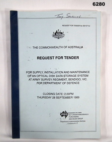
Administrative record - RFT - Supply and Maintenance of an Optical Disk Data and Retrieval Storage System, PSG Operations Branch, Purchasing and Sales Group, Department of Administrative Services, Canberra ACT, September 1989
This Request for Tender (RFT) 59/10713J is for the archival storage of digital mapping data produced by the Automap 1 and Automap2 computerised mapping systems. The RFT Closed on 28 September 1989.A4 Booklet, Light Blue Cover, Dark Blue plastic Bindingroyal australian survey corps, rasvy, fortuna, army survey regiment, army svy regt, asr -
 Bendigo Military Museum
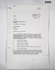
Letter - Army Survey Regiment - Letter of request for additional computer disk space for Automap 2, Army Survey Regiment, 19 Feb 1987
Automap 2 was the Army Survey Regiment's computerized Mapping system. This letter is a request for an additional 700 Mb of computer disk space for the Automap 2 System because of newly developed applications. Those applications were: Analytical Hill shading, Digital Terrain Modelling, Mask and stipple Production, RAAF Chart symbol Placement, ASTIS - Army Survey - Topographic Information System, and, Map Catalog Production.Two page letter, foolscap size, Stapled top left corner"A Spurling, Computer Operations Manager for CO"royal australian survey corps, rasvy, fortuna, army survey regiment, army svy regt, asr -
 Waverley RSL Sub Branch
Plaque Royal Australian Engineers, Royal Australian Engineers
The Royal Australian Engineers (RAE) is a corps of the Australian Army (although the word corps does not appear in their name or on their badge). The RAE is ranked fourth in seniority of the corps of the Australian Army, behind the Staff Cadets, Armoured and Artillery Corps. The Corps was formed by the amalgamation of the various colonial engineer corps of the States and territories of Australia in 1902[2] and since then has served in various conflicts including World War I, World War II and the Vietnam War. The Corps has also served on numerous peacekeeping operations and is currently involved in the Australian contribution to the war in Afghanistan. The RAE provides combat engineering, construction and other technical support to the Australian Defence Force. One of the main roles of the Corps is to provide mobility and counter mobility capabilities to the Australian Army and its allies. This means enhancing the ability of friendly forces to move while denying movement to enemy forces. In order to provide these capabilities, engineers are required to conduct many tasks including penetrating minefields, locating and disarming booby traps, purifying water and building roads and bridges. The Corps also performs the majority of the Australian Army's demolition tasks and is trained to fight as infantry if needed. http://en.wikipedia.org/wiki/Royal_Australian_EngineersWooden Plaque 15cm x 13cmRoyal Australian Engineers -
 Waverley RSL Sub Branch
Minefield Warning Flag
German Luftwaffe (Land Forces) minefield warning flag from WWII.originally intended to be gas markers, rather than mines, but as it turned out, the use changed .they were mounted on a red metal pole & there were 12 to a set in a leather pack. This Flag was presented to the Treasurer of Waverley RSL. It is a souvenir from Bardia in Libya The Battle of Bardia was fought over three days between 3 and 5 January 1941, as part of Operation Compass, the first military operation of the Western Desert Campaign of the Second World War. It was the first battle of the war in which an Australian Army formation took part, the first to be commanded by an Australian general and the first to be planned by an Australian staff. Major General Iven Mackay's 6th Division assaulted the strongly held Italian fortress of Bardia, Libya, assisted by air support and naval gunfire, and under the cover of an artillery barrage. The 16th Infantry Brigade attacked at dawn from the west, where the defences were known to be weak. Sappers blew gaps in the barbed wire with Bangalore torpedoes and filled in and broke down the sides of the anti-tank ditch with picks and shovels. This allowed the infantry and 23 Matilda II tanks of the 7th Royal Tank Regiment to enter the fortress and capture all their objectives, along with 8,000 prisoners. In the second phase of the operation, the 17th Infantry Brigade exploited the breach made in the perimeter, and pressed south as far as a secondary line of defences known as the Switch Line. On the second day, the 16th Infantry Brigade captured the township of Bardia, cutting the fortress in two. Thousands of prisoners were taken, and the Italian garrison now held out only in the northern and southernmost parts of the fortress. On the third day, the 19th Infantry Brigade advanced south from Bardia, supported by artillery and the Matilda tanks, now reduced in number to just six. Its advance allowed the 17th Infantry Brigade to make progress as well, and the two brigades reduced the southern sector of the fortress. Meanwhile, the Italian garrisons in the north surrendered to the 16th Infantry Brigade and the Support Group of the British 7th Armoured Division outside the fortress. In all, some 36,000 Italian prisoners were taken. The victory at Bardia enabled the Allied forces to continue the advance into Libya and ultimately capture almost all of Cyrenaica. In turn this would lead to German intervention in the fighting in North Africa, changing the nature of the war in that theatre. Bardia boosted the competence and reputation of the Australian Army. Perhaps most important of all, it raised confidence in the possibility of an ultimate Allied victory around the world, which would lead to the Lend-Lease Act being passed in the United States http://en.wikipedia.org/wiki/Battle_of_BardiaCloth Flag bearing a skull and cross Bones on a metal spike mounted on a square varnished wooden basebardia, land mine, marker flag, minefield, mustard gas -
 Waverley RSL Sub Branch
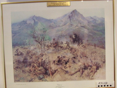
Print Kapyong, Kapyong
On 23 April, the 3rd Battalion, Royal Australian Regiment (3 RAR), under the command of Lieutenant Colonel Bruce Ferguson, and the 2nd Battalion, Princess Patricia's Canadian Light Infantry, occupied prominent hills on either side of the seven-kilometre-wide valley, where a small tributary joined the Kapyong River. Also forward were headquarters units, tanks and artillery. The 1st Battalion, Middlesex Regiment, were to the rear. Early in the evening, retreating South Koreans streamed past the Commonwealth position, with Chinese forces closely intermingled. Soon afterwards a platoon of American tanks supporting 3 RAR was overrun. The Kapyong valley was too large an area to defend with the forces available, and the brigade was spread very thinly. Throughout the night the Chinese repeatedly pressed the Australian positions, attacking in waves over their own dead and wounded. At dawn, A Company, under the command of Major Bernard "Ben" O'Dowd, found that the Chinese had infiltrated its position, but a counter-attack was able to eject them. Meanwhile B Company, which had spent the night on a hill near the riiver, discovered Chinese occupying some old bunkers on a small knoll. Hand-to-hand fighting ensued with grenades and bayonets. C Company, under the command of Captain Reg Saunders, was in position to reinforce both A and B Companies. "Major O'Dowd then directed the radio operator to contact anyone. The American 1st Marine Division answered but their operator refused to believe who our operator was speaking for. Major O'Dowd took the phone and demanded to speak to the commanding officer. The general in charge of the [Marine] division came on the phone and told O'Dowd we didn't exist as we had been wiped out the night before. Major O'Dowd said, 'I've got news for you, we are still here and we are staying here.'" Private Patrick Knowles, 3 RAR, on the morning of 24 April 1951 Fighting continued throughout the day with the Australians holding their positions, and the Chinese also engaging D Company. But late on 24 April, with their position now untenable, the Australians were forced into a fighting withdrawal down a ridge to the valley, where they rejoined the brigade. Their withdrawal was supported by New Zealand artillery from the 16th Field Regiment. Having found the Canadian position unassailable, the Chinese made no further attacks. By the afternoon of 25 April the road through to the Canadians had been cleared of Chinese and 2 PPCLI was relieved by US Army units. On Anzac Day 1951, the Australians rested after a long fight. Thirty-two Australians were killed and 53 were wounded for their part in stalling the Chinese advance and preventing Seoul from falling into enemy hands. Lieutenant Colonel Bruce Ferguson was awarded the Distinguished Service Order for his skilful leadership, and the Australian and Canadian battalions both received United States Presidential Distinguished Unit Citations for their part in the battle. http://www.awm.gov.au/exhibitions/korea/operations/kapyong/Print of painting of action in Kapyong Korea in wooden frame under glassDonated by Frank Arnold on behalf of Korean Veterans Association of Australia inc.korea, kapyong, 3rar -
 Running Rabbits Military Museum operated by the Upwey Belgrave RSL Sub Branch
Propeller for a DHC-4 Caribou light transport
DHC-4 Caribou light transport The Royal Australian Air Force DHC-4 Caribou was a versatile tactical light transport aircraft . Its main operational role was tactical air transport in support of the Australian Army. The Caribou was last operated by No 38 Squadron from RAAF Base Townsville in December 2009. The Caribou is a twin-engined high-wing monoplane with full-span double-slotted Fowler flaps and fully-reversible propellers, which allow it to achieve its trademark steep approach with very short take-offs and landings on unprepared runways. The high wing and distinctive high placement of the tail provide easy access to a large cargo compartment, while the low-pressure tyres permit operation on unprepared runways. It was the last piston-engined aircraft in the Air Force and was our only aircraft to employ the Low Altitude Parachute Extraction System (LAPES), where up to 2000kg of sled-mounted cargo is extracted from the aircraft by a parachute from a metre above the ground. The Caribou is equipped with GPS satellite navigation and night-vision equipment, giving it the capability to operate in any weather, day or night, to either land or drop soldiers and equipment by parachute with pinpoint accuracy. The Caribou is not pressurised and is not fitted with auto-pilot or weather radar. The first Caribou arrived in Australia in April 1964 and they were deployed to Vietnam from July 1964 to February 1972 and carried over 600,000 passengers and a huge quantity of cargo while they were there. Since 1997 the Caribou participated in famine-relief operations in Papua New Guinea and Irian Jaya during Operations SIERRA, PLES DRAI and AUSINDO JAYA, as well as the tsunami-relief operation in PNG in 1999 and operations in East Timor and the Solomon Islands since 1999. Their service life was over 40 years. raaf caribou aircraft -
 Lara RSL Sub Branch
Book, Jungle Warfare - With the Australian Army in the South West Pacific, 1944
This is the fourth book in this series to the people at home during WWII. Stories of military operations in the jungle and Kenai, mountains and swamps of New Guinea. There the terrain and climate gave to the fighting a character of its own, unlike anything experienced by Australians previously and never to be forgotten by those who took part in it.Jungle Warfare - With the Australian Army in the South West Pacific. Brown front and back cover with Ore text and picture of soldier carrying his webbing. Same text on the spine. The inside front and back cover has text ore coloured text on a brown background. Photographs, illustrations, poems, stories, paintings jungle warfare, new guinea, australian army, royal australian navy, united nations, amphibious operation, hidden battlefields, shaggy ridge, operational drop, life-saving moresby style, stretcher bearing -
Lara RSL Sub Branch
Book, Jungle Warfare - With the Australian Army in the South West Pacific, 1944
This is the fourth book in this series to the people at home during WWII. Stories of military operations in the jungle and Kenai, mountains and swamps of New Guinea. There the terrain and climate gave to the fighting a character of its own, unlike anything experienced by Australians previously and never to be forgotten by those who took part in it.Jungle Warfare - With the Australian Army in the South West Pacific. Brown front and back cover with Ore text and picture of soldier carrying his webbing. Same text on the spine. The inside front and back cover has text ore coloured text on a brown background. Photographs, illustrations, poems, stories, paintings. This book has a paper jacket cover - slightly torn. jungle warfare, new guinea, australian army, royal australian navy, united nations, amphibious operation, hidden battlefields, shaggy ridge, operational drop, life-saving moresby style, stretcher bearing -
 Lara RSL Sub Branch
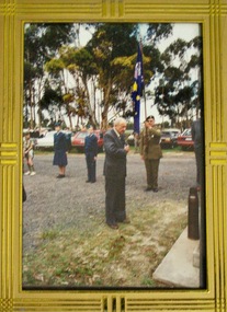
Framed Photograph of Anzac day service at Larea R.S.L, Circa 1980
Anzac Day is a national day of remembrance in Australia and New Zealand that broadly commemorates all Australians and New Zealanders "who served and died in all wars, conflicts, and peacekeeping operations" and "the contribution and suffering of all those who have served". Observed on 25 April each year, Anzac Day was originally devised to honour the members of the Australian and New Zealand Army Corps who served in the Gallipoli Campaign, their first engagement in the First World War. WikipediaAnzac Day is one of Australia’s most important national commemorative occasions. It marks the anniversary of the first major military action fought by Australian and New Zealand forces during the First World War.Rectangular shaped glass covered photo frame.anzac day service, world war one,lara r.s.l. -
 Bendigo Military Museum
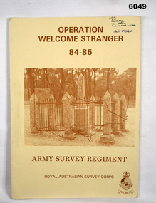
Administrative record - Army Survey Regiment - Operation Welcome Stranger - Operation Report
Operation Report of Mapping areas in central Victoria in 29 Mar 84 - 6 Mar 85. Covering 1:250,000 map areas SJ54-4 St Arnaud, SJ 55-1 Bendigo, SJ54-8 Ballarat, SJ %%-2 WangarattaAn A4 booklet sepia cardboard cover, brown text Survey Corps Badge, Photo of " Welcome Stranger Monument", outline shape of Victoria, glide on Arnos fastener binder.royal australian survey corps, rasvy, fortuna, army survey regiment, army svy regt, asr -
 Bendigo Military Museum
Photograph - Royal Australian Survey Corps Aerial Surveys, c1980
This is a set of nine photographs of technicians from the Royal Australian Survey Corps operating aerial surveys equipment c1980s. In photo .1P, CPL Steve Gloster was operating a RC10 air survey camera mounted in an Australian Army Pilatus Porter aircraft. The Wild RC10 super wide-angle air survey cameras were first introduced in 1971, were equipped with virtual distortion free lenses for supplementary, spot and special photography. In photo .2P, Roger Rees was operating Air Profile Recorder (APR) equipment. it was possibly taken during OP NERVOSE 84, sometime between June – August 1984 when based in Ngukurr, Northern Territory. The APR was operated at this time in unison with an RC10 camera. In 1963 the Royal Australian Survey Corps introduced the radar airborne profile recorder (Canadian Applied Research Ltd, Mark V, Airborne Profiler Recorder) was introduced for 1:100,000 mapping to replace terrain heighting by aneroid barometry. Later in 1974-1975, the Australian developed WREMAPS II airborne laser terrain profile recorder was introduced. In photo .3P, Neil Jones appears at the door of Airsearch Beechcraft Queen Air aircraft, Registration / Serial VH-MWX. This aircraft was typically used by RA Svy on air survey operations flying mission with Aerodist, APR and RC10 camera equipment. The Australian Army’s Pilatus Porter (short take-off and landing turbo propeller) was also equipped with a Wild RC10 aerial mapping camera for identification photography. The Pilatus Porter was also used on RA Svy’s map field checking operations. Photo .9P was taken at a survey station at an unknown location. In this photo an Australian Army Kiowa Light Observation Helicopter (LOH) is supporting a field survey party undertaking Magnavox AN/PRR-14 portable Doppler satellite observations. The satellite receiver’s antenna is plumbed over the survey ground mark surrounded by white plastic panels. The panels were used to identify the survey station on aerial photography. Introduced in 1974–1975, the Magnavox AN/PRR-14 portable Doppler satellite (US Navy Navigation Satellite System – TRANSIT) receivers and computing system provided independent three-dimensional point positions anywhere in the world, anytime, in any weather accurate to about 1.5metres with precise satellite ephemerides. The Bell OH-58 Kiowa LOH was a family of military helicopters used for observation, utility, and direct fire support. It was identified by RA Svy in the mid-1970s that considerable time was lost in replacing unserviceable remote equipment by road. Therefore Aerodist operations (pre-dating satellite receiver operations) were fully supported by Army’s Kiowa LOH aircraft. This is a set of nine photographs of technicians from the Royal Australian Survey Corps operating aerial surveys equipment c1980s. .1P to .3P, .5P to .9P - Colour and black and white photos on photographic paper and scanned at 300 dpi. .4P - Colour photo on 35mm slide film and scanned at 96 dpi. .1) & .2) - Photo, black & white, c1980s, CPL Steve Gloster operating an RC10 air camera. .3) - Photo, colour, 1984, Roger Rees operating Air Profile Recorder (APR) equipment. .4) - Photo, colour, c1980s, Neil Jones at the door of an Airsearch Beechcraft Queen Air aircraft, typically used by RA Svy on air survey operations. .5) - Photo, colour, c1980s. A Beechcraft King Air aircraft, also used by RA Svy on air survey operations. .6) - Photo, colour, c1980s. An Australian Army Pilatus Porter, used by RA Svy on air survey and map field checking operations. SGT Peter Mustart is possibly in the foreground. .7) to .8) - Photo, colour, c1980s. An Australian Army Pilatus Porter and unidentified personnel, used by RA Svy on air survey and map field checking operations. .9) - Photo, colour, c1980s. An Australian Army Kiowa helicopter supporting a field survey party undertaking Magnavox AN/PRR-14 portable Doppler satellite observations. There are biro marks on photos .4P to .9Proyal australian survey corps, rasvy, army survey regiment, asr, fortuna, aerial surveys -
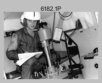
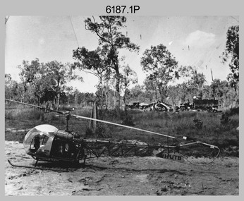 Bendigo Military Museum
Photograph - Bell 47G-2 helicopter used in Royal Australian Survey Corps Field Operations, c1965
... helicopters used in Royal Australian Survey Corps Field Operations ...This is a set of four photographs of Bell 47G-2 helicopters used in Royal Australian Survey Corps Field Operations. c1965. From 1957, helicopter transport of survey parties revolutionised transport in remote areas. The most common helicopter used by the Royal Australian Survey Corps at this time was the civilian Bell 47G-2 and the Sioux, the Australian Army’s’s equivalent. equivalent. From 1964 an Aerodist MRC2 airborne Electronic Distance Measuring (EDM) system was extensively used for topographic surveys over long distances by trilateration to replace traverse requiring survey station intervisibility. In 1965 the command field survey unit personnel attached to the Army Survey Regiment’s Topographic Squadron were used mainly in support roles such as station clearing, tower operations, station monumenting, Aerodist computations, forward base operations, geodetic observations on the north-south traverse and logistic support for Remote teams. .1P is a photo of a civilian Bell 47G-2 helicopter Registration / Serial VH-UTB owned by Helicopter Utilities from Mascot, NSW c1965. In the background of this photograph is three personnel and vehicles at a field survey camp. The left-hand vehicle is a Willys Jeep with trailer and on the right is probably a Truck, 2 1/2 ton, 6x6, General Service GMC. The Bell 47G-2: VH-UTB was destroyed, and its pilot killed in tragic circumstances during a civilian survey operation on Cape York Peninsula in June 1966. .2P is a photo of a a civilian Bell 47G-2 helicopter Registration / Serial VH-IHB taken in Wyndham, WA. As the letters ‘TAA’ appear on the fuselage, the helicopter was charted from Trans Australian Airways. .3P is a photo of a Bell 47G-2: VH-UTC with survey camp in background. .4P is a photo of a Bell 47G-2 equipped with floats and unidentified personnel loading stores, possibly in Darwin. Acknowledgement: Royal Australian Survey Corps – Aerodist Years 1964-1975 Version 2021.0 Authored by Peter Jensen.This is a set of four photographs of civilian Bell 47G-2 helicopters used in Royal Australian Survey Corps Field Operations. c1965. The photographs were printed on photographic paper and are part of the Army Survey Regiment’s Collection. The photographs were scanned at 300 dpi. .1) - Photo, black & white, c1965, Bell 47G-2 helicopter: VH-UTB with survey camp in background. .2) - Photo, black & white, c1965, Bell 47G-2 helicopter: VH-IHB with survey station in foreground. .3) - Photo, black & white, c1965, Bell 47G-2 helicopter: VH-UTC with survey camp in background. .4) - Photo, black & white, c1965, Bell 47G-2 helicopter: Unidentified personnel loading stores possibly in Darwin..2P – annotated on bottom of photo ‘Wyndham Area – Helicopter drops observing party’ The other photographs are not annotated.royal australian survey corps, rasvy, army survey regiment, army svy regt, fortuna, asr, surveying -
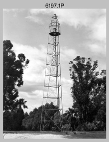 Bendigo Military Museum
Photograph - Royal Australian Survey Corps Survey Observation Towers, c1950s
This is a set of seven photographs of Royal Australian Survey Corps surveyors setting up observation towers in the field and undertaking survey observations during mapping and geodetic control operations. c1950s. Survey observation towers were used mainly to take angular measurements in flat or heavily forested terrain, where height was necessary to achieve observer’s line-of-sight between field survey station. The Bilby Tower seen in photo .5P was erected to a height of 75 feet (23m) above ground level. The use of the Bilby Tower in Topographic Squadron’s field survey operations from 1955 to 1966 is described in page 54 of Valerie Lovejoy’s book 'Mapmakers of Fortuna – A history of the Army Survey Regiment’ ISBN: 0-646-42120-4. CAPT George Ricketts’ period of service was from 1942 to 1976 reaching the rank of LTCOL. It is noted in page 35 of Valerie Lovejoy’s book that then SGT Ricketts hand lettering skills came to the fore from his contribution to the draughting of one of the Japan’s Instruments of Surrender in 1945.This is a set of seven photographs of Royal Australian Survey Corps surveyors setting up observation towers in the field and undertaking survey observations during mapping and geodetic control operations. c1950s. The photographs were printed on photographic paper and are part of the Army Survey Regiment’s Collection. The photographs were scanned at 300 dpi. .1) - Photo, black & white, c1950s, ‘Bilby’ survey observation tower. .2) - Photo, black & white, c1950s, CAPT George Ricketts climbing ‘Bilby’ survey observation tower. .3) - Photo, black & white, c1950s, geodetic survey equipment on ‘Bilby’ survey observation tower. .4) - Photo, black & white, c1950s, two unidentified field surveyors on ‘Bilby’ survey observation tower. .5) - Photo, black & white, c1950s, two unidentified field surveyors, with CAPT Ricketts climbing ‘Bilby’ survey observation tower. .6) - Photo, black & white, c1950s, two unidentified field surveyors undertaking observations on survey observation tower. .7) - Photo, black & white, c1950, two unidentified field surveyors erecting or dismantling a survey observation tower..1P with paper tag annotated ‘Bilby Tower’ .4P on back – ‘Bilby Tower’. .5P on back – ‘Survey Observing Tower. Observing tower used for angular measurement in flat country. 75’ high – CAPT Ricketts climbing. .6P, .7P on back. ‘1960s?’royal australian survey corps, rasvy, army survey regiment, army svy regt, fortuna, asr, surveying -
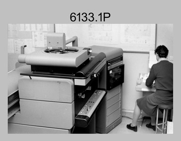 Bendigo Military Museum
Photograph - Orthophotomap Workstation, Lithographic Squadron – Army Survey Regiment, Fortuna, Bendigo, 1988
This collection of four photos was most likely taken at Lithographic Squadron, Army Survey Regiment, Fortuna, Bendigo in 1988. Orthophoto mapping provided the Survey Corps with the capability to produce map products quickly in the event of a crisis. These are four photographs of equipment used by the Army Survey Regiment to produce orthophotomaps. The OR1 orthophoto projector and workstation was introduced in the mid-1980s. It was the second-generation equipment used to orthorectify colour and monochrome film aerial photography, replacing the system introduced in 1973. Orthorectification is the process of removing geometric distortions and scale errors/variations from images. Images have tilt and relief distortions that make it difficult to compare accurately a map and an image of the same geographic area. Once an image is orthorectified, features on the image are shown in their planimetric locations. These four photographs of orthorectification equipment in operation were taken at the Army Survey Regiment at Fortuna, Bendigo, 1988. The photographs were on 35mm negative film and were scanned at 96 dpi. They are part of the Army Survey Regiment’s Collection. .1) to .4) - Photo, black & white, 1988, WILD OR-1 Orthorectification Workstation, SPR Carmel (Butler) Fauth.No personnel are identifiedroyal australian survey corps, rasvy, army survey regiment, army svy regt, fortuna, asr, litho -
 Bendigo Military Museum
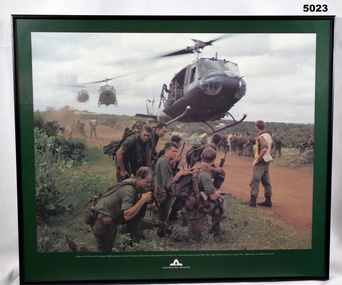
Print - PRINT, FRAMED
Caption under print. Soldiers of 5 Platoon, B Company, 7 RAR, preparing to board VS Iroquois helicopters during operation Ulmarrah, the cordon and search of Lang Phuoc Hai Village, South Vietnam, 26 August 1967". Members of 5 Platoon, B Company, 7th Battalion, The Royal Australian Regiment (7RAR), just north of the village of Lang Phuoc Hai, beside Route 44 leading to Dat Do. United States Army Iroquois helicopters are landing to take them back to Nui Dat after completion of Operation Ulmarra, the cordon-and-search by 7RAR of the coastal village of Lang Phuoc Hai. Operation Ulmarra was conducted by 2nd Battalion, The Royal Australian Regiment (2RAR) and 7RAR with support elements. Left to right: Private (Pte) Peter Capp (kneeling); Pte Bob Fennell (leaning over, facing camera, with an ammunition belt for an M60 machine gun slung over his shoulder); Corporal Bob D'Arcy (partly obscured behind Fennell); Pte Neal Hasted (centre, front); Pte Ian Jury (partly obscured, centre, rear, holding rifle); Pte Colin Barnett (front, right, M60 ammunition belt on back, back of head to camera); Lance Corporal Stan Whitford (partly obscured behind Barnett); the helicopter marshal at right is Pte John Raymond Gould, 7RAR. The United States Army Iroquois UH-1D helicopter was operated by 2 Platoon, 162nd Assault Helicopter Company, 11th Combat Aviation Battalion. (Having achieved almost the status of an icon, this image was chosen for, and is etched on, the Australian Vietnam Forces National Memorial on Anzac Parade, Canberra, ACT, dedicated in October 1992). Source AWM Print donated and dedicated to 3789179 FRANK FRIGERIO, 5 Platoon, B Company, 7RAR. See also Cat No. 3543-3549.3Print - coloured print of a photograph depicting three helicopters coming in to land above a dirt road with several groups of soldiers in uniform with jungle vegetation in the background. Frame - black painted metal.See in context, historical - caption under print.prints, framed, accessories, vietnam war -
 Lara RSL Sub Branch
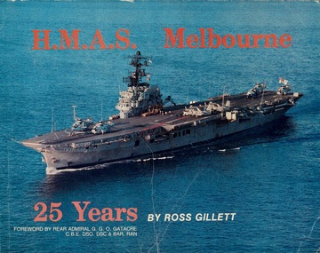
Book, Nautical Press, HMAS Melbourne 25 Years
HMAS Melbourne (R21) was a Majestic-class light aircraft carrier of the Royal Australian Navy (RAN). Operating from 1955 until 1982, she was the third and final conventional aircraft carrier to serve in the RAN. Melbourne was the only British Commonwealth naval vessel to sink two friendly warships in peacetime collisions. The ship was laid down for the British Royal Navy as the lead ship of the Majestic class in April 1943, and was launched as HMS Majestic (R77) in February 1945. At the end of World War II, work on the ship was suspended until she was purchased by the RAN in 1947. At the time of purchase, it was decided to incorporate new aircraft carrier technologies into the design, making Melbourne the third ship to be constructed with an angled flight deck. Delays in construction and integrating the enhancements meant that the carrier was not commissioned until 1955. Melbourne never fired a shot in anger during her career, having only peripheral, non-combat roles in relation to the Indonesia-Malaysia confrontation and the Vietnam War. However, she was involved in two major collisions with allied vessels. On the evening of 10 February 1964, Melbourne collided with and sank HMAS Voyager when the Daring class destroyer altered course across her bow. Eighty-two of Voyager's crew were killed, and two Royal Commissions were held to investigate the incident. The second collision occurred in the early morning of 3 June 1969, when Melbourne collided with and sank the Allen M. Sumner class destroyer USS Frank E. Evans in similar circumstances. Seventy-four United States Navy (USN) personnel died, and a joint USN–RAN Board of Inquiry was held. These incidents, along with several minor collisions, shipboard accidents, and aircraft losses, led to the reputation that Melbourne was jinxed. Melbourne was paid off from RAN service in 1982. A proposal to convert her for use as a floating casino failed, and a 1984 sale was cancelled, before she was sold in 1985 and towed to China for breaking. The scrapping was delayed so Melbourne could be studied by the People's Liberation Army Navy (PLAN) as part of a secret project to develop a Chinese aircraft carrier and used to train PLAN aviators in carrier flight operations. HMAS Melbourne was decommissioned on 30 June 1982, having spent 62,036 hours underway and having steamed 868,893 nautical miles. A proposal to convert her for use as a floating casino failed, and a 1984 sale was cancelled, before she was sold for scrap in 1985 and towed to China for breaking. The scrapping was delayed so Melbourne could be studied by the People's Liberation Army Navy (PLAN) as part of a secret project to develop a Chinese aircraft carrier and used to train PLAN aviators in carrier flight operations.The pictorial history of HMAS Melbourne with rare photos. Now a scarce title and highly desirable title that is now long out of print. Has provenance history of all ships movements from 1955 till decommissioned.HMAS Melbourne 25 YearsOn the front page is a picture of HMAS Melbourne with the words at top "H.M.A.S. Melbourne. At bottom are the words in orange, '25 Years'. In white, are the words 'by Ross Gillett' then 'Forward by Rear Admiral G.G.O. Gatacre C.B.E. DSO. DSC & Bar, RAN'. On the rear page is a list of all the Captains that served on the HMAS Melbourne between 1955-1980.hmas melbourne, aircraft carrier, royal australian navy, australian navy, westland whirlwind, sea venom, fairy gannet, bristol sycamore, westland wessex, douglas skyhawk, grumman tracker, westland sea king, fleet air arm, hmas albatross, nowra -
Lara RSL Sub Branch
Book, Jungle Warfare - With the Australian Army in the South West Pacific, 1944
This is the fourth book in this series to the people at home during WWII. Stories of military operations in the jungle and Kenai, mountains and swamps of New Guinea. There the terrain and climate gave to the fighting a character of its own, unlike anything experienced by Australians previously and never to be forgotten by those who took part in it.Jungle Warfare - With the Australian Army in the South West Pacific. Brown front and back cover with Ore text and picture of soldier carrying his webbing. Same text on the spine. The inside front and back cover has text ore coloured text on a brown background. Photographs, illustrations, poems, stories, paintings jungle warfare, new guinea, australian army, royal australian navy, united nations, amphibious operation, hidden battlefields, shaggy ridge, operational drop, life-saving moresby style, stretcher bearing -
 Shepparton RSL Sub Branch
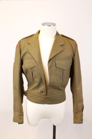
Uniform, Jacket, E.W. PTY/LTD, 1968
This jacket is part of a Royal Australian Army Ordnance Corps uniform. The Royal Australian Army Ordnance Corps (RAAOC) is responsible for various logistics and organisational operations, such as maintenance of parachutes, fuel distribution, personnel administration, exlosive disposal and laundy operations. The jacket was manufactured in 1968 and was worn by an unknown RAAOC serviceman. The patches on his sleeves denote that he had earned qualifications as a parachuter and a marksman and that he was a Warrant Officer 1. Due to the period of manufacture it can be presumed that the serviceman whom this uniform belonged to served Vietnam War.As an historic military uniform dating to 1968, it is presumed that this item would have been used in service during the Vietnam War. The wearer of the uniform is unknown, however the patches and flashes attached signify that the serviceman worked for the Royal Australian Army Ordnance Corps, earned qualifications as a parachuter and marksman and ranked highly as a Warrant Officer 1. The item is representative of a type of uniform worn by high ranking RAAOC servicemen during the 1960’s. It is also in very good condition for its age.A khaki coloured waist length jacket which is composed of a heavy fabric. The jacket fastens with five buttons down the front and a buckle. The buttons are composed of brown plastic and the buckle is a dark grey metal. The buckle is attached to a waistband on the right-hand side which loops around to a strip of fabric on the left-hand side which passes through the buckle. There are two breast pockets, one on each side of the chest. The right breast pocket is fastened with a brown plastic button and the left breast pocket is missing its button. Each pocket has a flap of fabric which covers the button area. The jacket has a collar and an epaulette on each shoulder which are each fastened with one brown plastic button. There is a ribbon of fabric on the interior of the collar with no inscriptions. There are identical crescent shaped red patches on each shoulder, each showing the words in navy blue stitching "Royal Australian Army Ordinance Corps". The upper right sleeve has a khaki coloured parachuting qualification patch, which depicts an air balloon in white stitching, with wings on either side in light blue stitching. The lower section of each sleeve has a Warrant Officer First Class khaki coloured patch. This depicts a shield in red, black, white, blue and gold stitching in the centre which sits beneath a gold and blue striped line and a gold star. There is a gold kangaroo to the left of these motifs and a gold emu to the right. Beneath these motifs there is a ribbon in white, blue and gold stitching with the word "Australia". In addition there are curvilinear green decorative elements with yellow flowers on their ends. The left-hand sleeve also has a brown marksmen qualification patch. This depicts two crossed rifles in white and brown stitching. There is a white label with printed inscriptions on the interior of the left breast pocket. There is also a band of fabric on the interior back waist band which has three button holes.Printed in black inscriptions on the white label: E.W. PTY/LTD. SOUTH AUSTRALIA 1968 (a broad arrow) Class 8405-66-025-641 Batch A.W... Mill (the ‘A.W...’ is in stamped purple ink and there are some other purple inscriptions that are difficult to decipher) SIZE OF CHEST 39/49PR MATCHING TROUSERS 37 PR DRY CLEAN ONLY CREASE UPPER HALF OF LAPELS ONLY NAME..... ARMY No..... (the number 40 is also wrtten in faded black ink in the top right corner of the label)military, jacket, army, raaoc, royal australian army ordnance corps, parachuting, marksman, warrant officer, uniform -
 Shepparton RSL Sub Branch
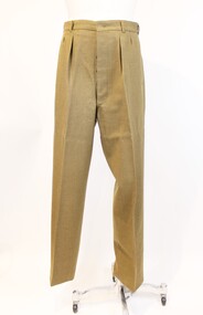
Uniform, trousers, Conway Bros. PTY. LTD, 1969
These trousers are part of a Royal Australian Army Ordnance Corps uniform. The Royal Australian Army Ordnance Corps (RAAOC) is responsible for various logistics and organisational operations, such as maintenance of parachutes, fuel distribution, personnel administration, exlosive disposal and laundy operations. The trousers were manufactured in 1969 and were worn by an unknown RAAOC serviceman. The patches on the sleeves of the corresponding jacket denote that he had earned qualifications as a parachuter and a marksman and that he was a Warrant Officer 1. Due to the period of manufacture it can be presumed that the serviceman whom this uniform belonged to served in the Vietnam War.As historic military uniform trousers dating to 1968, it is presumed that this item would have been used in service during the Vietnam War. The wearer of the uniform is unknown, however the patches and flashes attached signify that the serviceman worked for the Royal Australian Army Ordnance Corps, earned qualifications as a parachuter and marksman and ranked highly as a Warrant Officer 1. The item is representative of a type of uniform worn by high ranking RAAOC servicemen during the 1960’s. It is also in very good condition for its age.khaki coloured trousers which are composed of a heavy fabric. The trousers button up at the front with 6 plastic buttons. There is an additional strip of fabric attached to the right-hand fly which can be fastened with an extra button on the interior of the left-hand fly. There are an additional 6 buttons along the interior waistband. There are also three buttons on the exterior waistband down the front and a buckle. The buttons are composed of brown plastic. There are two open hip pockets, one on either side, and another button-up pocket on the right-hand side of the back. There is a white label with inscriptions attached to the interior of the back pocket with an extra piece of fabric attached for mending patches.Printed in black inscriptions on the white label: CONWAY BROS. PTY. LTD ADELAIDE 1969 (a broad arrow) Class 8405-66-025-6183 A W M 7 (these characters are stamped in faded black ink) SIZE & WAIST 33R MATCHING JACKET 37-38R in a box are the words: DRY CLEAN ONLY. Re-press on original seams. Creases set by Si-ro-set. Mending patch attached. (end of box containing words) NAME.....DOCKSEY (‘Docksey is in hand-written black ink) ARMY No.....216308 (numbers also hand-written in black ink) (the number 40 is also wrtten in faded black ink in the top right corner of the label)military, army, raaoc, marksman, royal australian army ordnance corps, parachuting, warrant officer, uniform, trousers -
 Shepparton RSL Sub Branch
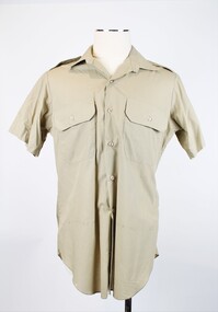
Uniform, Shirt, Australian Defence Industries, 1989
... the-murray This shirt is part of a Royal Australian Army Ordnance ...This shirt is part of a Royal Australian Army Ordnance Corps uniform. The Royal Australian Army Ordnance Corps (RAAOC) is responsible for various logistics and organisational operations, such as maintenance of parachutes, fuel distribution, personnel administration, explosive disposal and laundy operations.Short sleeved khaki shirt in light polyester material. Fastened by seven plastic buttons along centre. Two chest pockets fastene with externa flap and button. Fabric shoulder epaulettes on left and right side held in place with a plastic button. Label on interior back of neck and stamp on collar.Printed in black inscriptions on the white label: “ADI P/L/VIC 1989/[broad arrow]/SIZE. 40/8405-66-093-8319/SERVICE NO/NAME/DO NOT BOIL OR WRING/MACHINE WASHABLE/DRIP DRY, IRON LIGHTLY/WITH WARM IRON”. “SIZE 40” is stamped in black into on interior collar. Inscription handwritten on interior lower back panel “4800045/MARTINS.”military, army, raaoc, royal australian army ordnance corps, uniform, parachuting, marksman, warrant officer -
 Lara RSL Sub Branch
Medallion, W.H.Mathews, 1967
Every Anzac soldier who served on the Gallipoli Peninsula, or in direct support of operations there - or his family if he did not survive until into the late 1960s - was entitled to be issued with the Anzac Commemorative Medallion. The Medallion was issued in 1967. The medallion was sent by registered post and comes in a presentation case with a moulded velvet base to receive the medallion, with a silk lined hinged lid.Medallion presented to all army personnel serving at GallipoliANZAC Medallion Badge issued in memory of W.H. MathewsThe obverse of the medallion depicts Simpson and his donkey carrying a wounded soldier to safety. It is bordered on the lower half by a laurel wreath above the word ANZAC and the date 1915 above the donkey. The reverse shows a map in relief of Australia and New Zealand superimposed by the Southern Cross. The lower half is bordered by New Zealand fern leaves and the name W.M. Mathewsmedallion, army, anzacs, australian army, world war 1, ww1, gallipoli -
 Federation University Historical Collection
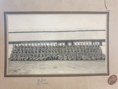
Photograph, Melba & Co, 7th Australian Infantry Training Battalion WW1
George Alfred Yung, known as Alf, pictured in the second row, 10th from the left, enlisted on 25/02/1916; embarked on 19/02/1917; was killed during the battle of Menin Gate at Yrpres, Belgium on 20/09/1917. https://www.awm.gov.au/collection/U51447 The 7th Battalion was among the first infantry units raised for the AIF during the First World War. Like the 5th, 6th and 8th Battalions, it was recruited from Victoria and, together with these battalions, formed the 2nd Brigade. The battalion was raised by Lieutenant Colonel H. E. "Pompey" Elliott within a fortnight of the declaration of war in August 1914 and embarked just two months later. After a brief stop in Albany, Western Australia, the battalion proceeded to Egypt, arriving on 2 December. It later took part in the ANZAC landing on 25 April 1915, as part of the second wave. Ten days after the landing, the 2nd Brigade was transferred from ANZAC to Cape Helles to help in the attack on the village of Krithia. The attack captured little ground but cost the brigade almost a third of its strength. The Victorian battalions returned to ANZAC to help defend the beachhead, and in August the 2nd Brigade fought at the battle of Lone Pine. While holding positions captured by the 1st Brigade, four members of the 7th Battalion, Corporal A. S. Burton, Acting Corporal W. Dunstan, Lieutenant W. Symons and Captain F. H. Tubb, earned the Victoria Cross - Burton posthumously. The battalion served at ANZAC until the evacuation in December. After the withdrawal from Gallipoli in December 1915, the battalion returned to Egypt. In March 1916, it sailed for France and the Western Front and entered the front line trenches for the first time on 3 May. The battalion's first major action in France was at Pozieres in the Somme valley where it fought between 23-27 July and 15-21 August. After Pozieres the battalion manned trenches in the Ypres salient in Belgium, before returning to the Somme valley. It saw out the horrendous winter of 1916-1917 rotating between training, working parties and duty in the trenches. In early 1917, the Germans withdrew to the Hindenburg Line and the 7th Battalion participated in the brief advance that followed and then came to a grinding halt before Bullecourt. The battalion was withdrawn from the front line for training on 9 May 1917 and did not return to action until the Ypres offensive of September and October. It fought major battles at Menin Road on 20 September and Broodseinde on 4 October, and then spent much of ensuing winter in the Ypres mud. In March and April 1918 the 7th helped stop the German spring offensive in northern France and later participated in the Allies' own great offensive of 1918, that began with the battle of Amiens on 8 August. The advance by British and empire troops on 8 August was the greatest success in a single day on the Western Front, one that German General Erich Ludendorff described as, "the black day of the German Army in this war". The battalion continued operations until late September 1918. At 11 am on 11 November 1918, the guns fell silent. The November armistice was followed by the peace treaty of Versailles signed on 28 June 1919. In November 1918 members of the AIF began to return to Australia for demobilisation and discharge. In March, the battalion was so reduced that it and the 6th Battalion were amalgamated to form a composite battalion. In turn, this battalion was merged with another, formed from the 5th and 8th Battalions, to form the 2nd Brigade Battalion. https://www.awm.gov.au/collection/U51447army, soldier, alf yung, 7th australian infantry battalion -
 Bendigo Military Museum
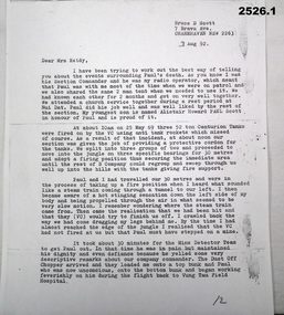
Letter - LETTER, VIETNAM, 3.8.1992
Letter written to Mrs Reidy by her son Paul's Section Commander BRUCE D SCOTT. It details the circumstances of PAUL REIDY'S death in Vietnam on 25.5.1969. It was during “Operation Reynella” around the Long Hai Mountains. Paul Francis Reidy No 3793403. A National Serviceman Paul served Vietnam first in 1 ARU from 24.2.1969 - 17.3.1969 and then posted to B Coy 9 RAR 18.3.1969 until his death. Bruce Donaldson Scott No 213485. Australian Regular Army served Vietnam first in 1 ARU from 10.3.1969 - 1.4.1969 and then posted to B Coy 9 RAR 2.4.1969 until being Medivaced home on 2.6.1969. 1 ARU (1st Australian Reinforcement Unit) 9 RAR (9th Battalion of the Royal Australian Regiment) Refer 1189.5, 2224, 2237.2P re Paul Reidy. Copy of typed two page letter on A4 paper from BRUCE D SCOTT to Mrs Reidy.documents - letters, military history -
 Federation University Historical Collection
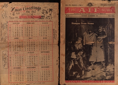
Newspaper - Twenty page issue December 1941 No. 93, Societe Orientale de Publicite, The A.I.F. News Special Christmas Issue 1941, December 1941
The A.I.F.= The Australian Imperial Force and this newspaper was supplied free to the troops of the Australian Army Canteens Service. This issue is dated Saturday 22nd December 1941. It includes advertisments for businesses in Cairo and Alexandria; Egypt, Palestine and Syria. Page 2 includes a poem titled "This Holy Night" by Pte C.M. Walker; two sonnets by Rupert Brooke; a poem, "Waiting Dreams" by Pilot Officer J.A. Henderson RAAF and a poem by Lieut. David McNicoll AIF Abroad Air Mail - Palestine. Page 3 includes a message from General Sir Thomas Blamey, an article on the part women would increasingly play as a consequence of the emergency war policy; an advertisment for tobacco specially packed for overseas forces. Page 4 includes an article on Australian coastal cities being ready for raids. Page 5 includes an article about the Commonwealth of the Philippines and their defense which until 1946 lay with America. General D Macarthur was the Commander In Chief in the Philippines. Germany's "secret Weapon" legend. Page 6 includes "Dancing Dan's Christmas"; "Bluey and Curley" comic strip. Page 7 includes article "Rommel's Armoured Might Lies Strewn Over Libyan Sands" Page 8 includes an article: "All In Fun" - a revue - has begun a tour of Australian camps in Palestine and Syria. Page 9 includes articles "War Will Revolutionise Air Services In Australia"; a list - Greek Awards To AIF Officers and a cartoon by George Aria titled 'Jonah '. Pages 10&11 "Christmas 1941" - messages from prominent people: Mr Winston Churchill; The Govenor General (Lord Gorrie); The Prime Minister (Mr Curtin); Mininster for the Army (Mr Forde). Also photos of army operations and traditional family Christmas time. Page 12 &13 Articles regarding sport under the heading 'Australian Sporting Digest'. Page 14 A story - "The Gift of the Magi" - an O Henry Christmas Story. Also a greeting from Myer's of Melbourne and Adelaide to all Myer Men in the AIF Page 15 An article where General Blamey reassures Australia about its capability of defence. Page 16 A description of a battle by Australian sloop "Parramatta" with HMAS "Auckland" against enemy planes whilst they were escorting a merchant ship with a cargo of petrol during the Battle of Tobruk Page 17 & 18 Pages under the title 'ACK-I-FOOFS' (Articles submitted by soldiers: The real Rat of Tobruk - a rat trained by L/Cpl Jack Kneeshaw which he named "Goebbels"; poems and cartoons. Page 19 "Women of War" - photos of women at work filling in for men who have gone to war. Page 20 Xmas Greetings 1942-1942 - a 1942 Calendar signed by 14 members of the AIF, some with messages and including their Army Number. Twenty pages of news supplied free to the troops by the Australian Army Canteens Service.The last page is a calendar for 1942 with personal inscriptions and greetings of servicemen. Some inscriptions have I.D. Numbers ( VX35435 W. Johnston; QX20753 of Carmody ; VX40449 ; VX39637 N. Powell; VX32054 Blue Ernistson?; N?X23234 W.Cummins; VXthe a.i.f. news christmas edition 1941, australian imperial force, world war 2, australian army canteens service, general blamey, world war 2 - pacific war, world war 2 - phillipine islands, general d macarthur, emergency plans ww2 australia, secret weapons ww2, western desert ww2, australian imperial force - western desert ww2, civil aviation post ww2, air services australia, lord gowrie, governor general lord gowrie, prime minister john curtain, minister for the army - mr forde, cartoons 1941, women-in ww2, xmas greetings calendar 1941-1942, cairo 1941, palestine 1941, western desert 1941, advertisements 1941, middle east 1941 -
 Frankston RSL Sub Branch
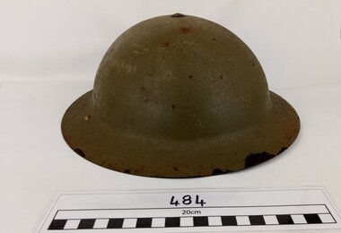
Helmet, Steel MK111
An example of a British pattern steel battle helmet painted dark Khaki, complete with camouflage netting, chin strap and inner support liner. This is an Australian Army type MK111 steel helmet, standard issue for Australian infantry personnel during WW11 operations. The inside of the helmet is padded with a protective, dense rubber liner and has an adjustable cotton webbing chin strap. Australian manufacture, dated 1942, similar to the British "Brodie" pattern steel helmet originally introduced during WW1. The rim of the helmet is stamped '1942' and is marked number '7'. -
4th/19th Prince of Wales's Light Horse Regiment Unit History Room
Flag, 173rd Airborne Brigade (US)
173 AIRBORNE BRIGADE (SEPARATE) US ARMY 1 RAR BATTLE GROUP BIEN HOA 1965-1966 On May 5, 1965, the Brigade deployed to South Viet Nam as the first US Army ground combat unit in that war. Upon arrival, the 1st Battalion of the Royal Australian Regiment (1 RAR) and a battery from New Zealand (161Royal NZ Artillery) were attached to the Brigade -- making the 173d Airborne the only multi-national combat unit in the war. Initially headquartered in Bien Hoa, the Brigade operated in the four provinces around Saigon. (Xuan Loc, Long Khanh, Phuoc Long & Phuoc Tuy), but (in its roll as a "Fire Brigade") also went to the Central Highlands (Pleiku / Kontum) to fight Viet Cong. The 173d also conducted constant operations against the southern stronghold of the VC Main Force in the legendary Iron Triangle in War Zone D. The brigade was organized as a balanced airborne combat force consisting of two infantry battalions, an artillery battalion, a support battalion, an engineer company, a cavalry troop, an armour company, and a headquarters company. Upon activation, it became the first and only separate airborne brigade in the United States Army. This was the beginning of a long series of "Firsts" for the Brigade. On 5 May 1965, it became the first US Army ground combat unit committed to the war in South Vietnam, where further organizational changes were to take place. Australians attached to the Brigade were: 1st Battalion, of the Royal Australian Regiment (I RAR) and support troops of the 4/19th Prince of Wales Light Horse Regiment (1Troop), 105 Field Battery Royal Australian Artillery, 161 Field Battery Royal New Zealand Artillery, 3 Field Troop Royal Australian Engineers, 161 Reconnaissance Flight, Royal Australian Army Air Corps, 1st Australian Logistical Support Company. The Brigade's two infantry battalions, the First Battalion of the 503' Infantry (1/503`d) and the Second Battalion, of the 503`d Infantry (2/503`) and the attached Australians of 1 RAR constituted the infantrymen available to the Brigade. Their mission was to protect the Bien Hoa Air Base and to close with and destroy or capture the enemy. This was in fact the first operational ground force formed under the ANZUS Defence Treaty. ANZUS was a mutual defence treaty signed in 1951 between Australia, New Zealand and the United States of America. In 1965 the spirit of this treaty appeared as 173d Airborne Brigade (Sep) a tri-national brigade. The only such tri-national fighting force formed during the Vietnam War. On deployment to South Vietnam in 1965, 1 Troop A Squadron, 4th/19th Prince of Wales's Light Horse Regiment was part of the US 173rd Airborne Brigade combat group. Flag, two colours divided vertically, hoist half mid blue, fly half red. Badge of 173rd Airborne Brigade (730 x 490 mm) in centreflag, 173rd airborne, south vietnam -
4th/19th Prince of Wales's Light Horse Regiment Unit History Room
Decorative Australian National Flag, 2007
The Security Detachment Iraq (SECDET Iraq) was the final component of Australia's contribution to coalition operations in Iraq. SECDET was based on an Australian Army combined arms combat team consisting of an infantry company group and a troop of cavalry which operated the Australian Light Armoured (ASLAV) vehicles. The force's duties included static security guarding at the Australian Embassy in Baghdad and the protection of Australian diplomats and vehicle convoys. SECDET was withdrawn in August 2011, with the firm Unity Resources Group becoming responsible for providing security for Australia's diplomatic presence in Iraq. SECDET XII 2007 • D Company, 6 RAR • Troop, 2/14 LHR (QMI) • Elements, 1st MP Bn • Combat Service Support Element Some members of 4/19 Prince of Wales's light Horse Regiment were deployed to SECDETMiniature Australian flag as souvenir of SECDET XI service - Operation Catalyst. Gold coloured material edgingVIID embroidered in lower right quadrant