Showing 93 items matching "bendigo aerial photos"
-
 Bendigo Military Museum
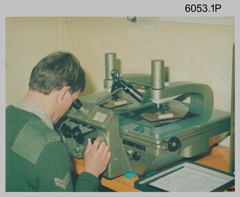
Photograph - Army Survey Regiment Map Production Equipment, c1980s, c1990s
Photos .1P, .2P, and.4P were most likely taken in the 1980s and photos .3P, .5P to .7P in the c1990s at the Army Survey Regiment, Fortuna, Bendigo. Despite lacking annotation on exact dates, locations and personnel, they are positively identified. CPL Ian Nelson in photo .1P is operating a Wild Pug 4 point transfer device in Air Survey Squadron c1980s. Control points were transferred onto the mapping diapositives of aerial photography by drilling their locations into the photographic emulsion. SPR Viv (Hawkins) Doherty in photo .2P, SPR Jeanette Drury-Lane in photo .5P and SGT Sandy Craig are operating a Wild B8 Stereoplotter coupled to a digital workstation in Air Survey Squadron c1994. Topographic features were extracted with the B8 in 3D and feature coded with attributes, using keyboard, menu, keypad and voice inputs to the computer. The features were stored in the AUTOMAP 2 digital database for subsequent cartographic production and printing. CPL Mick Ellis in photo .3P is operating the Optronix 4040 Scanner/Film Writer in Lithographic Squadron c1990s. In scanning mode, compilation sheets were mounted on the drum and scanned. The resultant raster file was vectorized, feature coded with attributes and stored by cartographic technicians in the AUTOMAP 2 database. In film writing mode, digital cartographic files were output at very high resolution for each print colour on photosensitive film, for subsequent finalisation, platemaking and printing.This is a set of seven photographs of technicians operating map production equipment at the Army Survey Regiment, Bendigo. The photographs were printed on photographic paper and are part of the Army Survey Regiment’s Collection. The photographs were scanned at 300 dpi. .1) - Photo, colour, c1980s. CPL Ian Nelson operating a Wild Pug 4 point transfer device in Air Survey Squadron. .2) - Photo, colour, c1980s. Wild B8 Aviograph stereoplotter feature extraction, SPR Viv (Hawkins) Doherty in Air Survey Squadron. .3) - Photo, colour, c1990s. CPL Mick Ellis operating the Optronics 4040 Scanner in Lithographic Squadron. .4) - Photo, colour, c1984. AUTOMAP 2 Graphic Edit Workstation, SPR Craig Kellet in Cartographic Squadron. .5) - Photo, colour, c1994. Wild B8 Aviograph stereoplotter feature extraction, SPR Jeanette Drury-Lane in Air Survey Squadron. .6) - Photo, colour, c1994. AUTOMAP 2 Graphic Edit Workstation, L to R: unidentified, SPR Rachel (Stanford) Scott, CPL Chris Wynn in Cartographic Squadron. .7) - Photo, colour, c1994. Wild B8 Aviograph stereoplotter AUTOMAP 2 Graphic Edit Workstation, L to R: unidentified (x2), SGT Sandy Craig in Air Survey Squadron..1P – no annotations .2P – annotated “Stereoplotter Workstation. The operator has the use of keyboard, menu, keypad and voice for input to the computer. Feedback is given through voice and screen messages.” .3 to .7P – no annotationsroyal australian survey corps, rasvy, army survey regiment, army svy regt, fortuna, air survey, litho, aerotrig, automap 2 -
 Bendigo Military Museum
Photograph - Photographic Technicians performing tasks at the Army Survey Regiment, c1970s
These eleven photographs were most likely taken in the 1970s in Lithographic Squadron at the Army Survey Regiment, Fortuna, Bendigo. Although Photo .1P is not annotated the remainder have the technician’s name written on the back. The equipment operated by the technicians is not identified. The dates are unknown but most of these photos were probably taken the late 1970s. The main tasks undertaken by the technicians were most likely enlargements, reductions and duplication of map reproduction material, and aerial photography.This is a set of photographs of technicians operating photographic reproduction equipment at the Army Survey Regiment, Bendigo c1970s. The photographs were printed on photographic paper and are part of the Army Survey Regiment’s Collection. The photographs were scanned at 300 dpi. .1) - Photo, black & white, c1970s, unidentified, Lithographic Squadron .2) - Photo, black & white, c1970s, Gary Drummond, Lithographic Squadron .3) - Photo, black & white, c1970s, John Scott, Lithographic Squadron .4) - Photo, black & white, c1970s, WILD U4A Diapositive Camera, Bob Chamberlain, Lithographic Squadron. 5) - Photo, black & white, c1970s, WILD U4A Diapositive Camera, Zoe (Lisiewich) Ames, Lithographic Squadron .6) - Photo, black & white, c1970s, Garry Hudson, Lithographic Squadron .7) - Photo, black & white, c1970s, Garry Hudson, Lithographic Squadron .8) - Photo, black & white, c1970s, Garry Hudson, Lithographic Squadron .9) - Photo, black & white, c1970s, Mick Ellis, Lithographic Squadron .10) - Photo, black & white, c1970s, Col Darch, Lithographic Squadron .11) - Photo, black & white, c1970s, Phil Beatty, Lithographic Squadron.1P – no annotation .2 to .11 – personnel names (less rank) annotated on back. royal australian survey corps, rasvy, army survey regiment, army svy regt, fortuna, asr, litho -
 Bendigo Military Museum
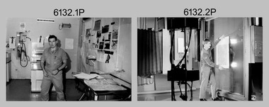
Photograph - Photo Troop, Lithographic Squadron – Army Survey Regiment, Fortuna, Bendigo, 1988
This collection of 10 photos was most likely taken at Lithographic Squadron, Army Survey Regiment, Fortuna, Bendigo in 1988. The main tasks undertaken by technicians in Photo Troop were most likely enlargements, reductions and duplication of map reproduction material, and processing of aerial photography.This is a set of 10 photographs of Photo Troop personnel and equipment from Lithographic Squadron at the Army Survey Regiment, Fortuna, Bendigo, 1988. The photographs were on 35mm negative film and were scanned at 96 dpi. They are part of the Army Survey Regiment’s Collection. .1) - Photo, black & white, 1988, BARCRO work area, SPR Gary Sievers. .2) - Photo, black & white, 1988, KLIMSCH Commodore camera, CPL Mick Gillham. .3) - Photo, black & white, 1988, KLIMSCH Commodore camera, CPL Mick Gillham. .4) - Photo, black & white, 1988, WILD U4A Diapositive Camera, SPR Rob Jones. .5) - Photo, black & white, 1988, WILD U4A Diapositive Camera, SPR Rob Jones. .6) - Photo, black & white, 1988, WILD U4A Diapositive Camera, SPR Rob Jones. .7) - Photo, black & white, 1988, WILD U4A Diapositive Camera, SPR Rob Jones. .8) - Photo, black & white, 1988, WILD U4A Diapositive Camera, SPR Rob Jones. .9) - Photo, black & white, 1988, Photographic camera enlarger, unidentified technician. .10) - Photo, black & white, 1988, SUPER CHROMEGA F Photographic camera enlarger. No personnel are identifiedroyal australian survey corps, rasvy, army survey regiment, army svy regt, fortuna, asr, litho -
 Bendigo Military Museum
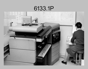
Photograph - Orthophotomap Workstation, Lithographic Squadron – Army Survey Regiment, Fortuna, Bendigo, 1988
This collection of four photos was most likely taken at Lithographic Squadron, Army Survey Regiment, Fortuna, Bendigo in 1988. Orthophoto mapping provided the Survey Corps with the capability to produce map products quickly in the event of a crisis. These are four photographs of equipment used by the Army Survey Regiment to produce orthophotomaps. The OR1 orthophoto projector and workstation was introduced in the mid-1980s. It was the second-generation equipment used to orthorectify colour and monochrome film aerial photography, replacing the system introduced in 1973. Orthorectification is the process of removing geometric distortions and scale errors/variations from images. Images have tilt and relief distortions that make it difficult to compare accurately a map and an image of the same geographic area. Once an image is orthorectified, features on the image are shown in their planimetric locations. These four photographs of orthorectification equipment in operation were taken at the Army Survey Regiment at Fortuna, Bendigo, 1988. The photographs were on 35mm negative film and were scanned at 96 dpi. They are part of the Army Survey Regiment’s Collection. .1) to .4) - Photo, black & white, 1988, WILD OR-1 Orthorectification Workstation, SPR Carmel (Butler) Fauth.No personnel are identifiedroyal australian survey corps, rasvy, army survey regiment, army svy regt, fortuna, asr, litho -
 Bendigo Military Museum
Photograph - PHOTOGRAPHS, 1939-1945
Albert Edward Corrie VX47191, Postal Unit.1. Four men leaning on truck. 2. Four men seated with mailbags. 3. Four men seated with mailbags. 4. Four men seated in a motor vehicle. 5. Two men feeding a seal. 6. Large pile of mailbags. 7. Aerial photo of 5 (five) aero planes. photographs, postal unit, ww2 -
 Bendigo Military Museum
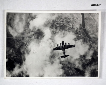
Photograph, c.WWII
Photograph of a Lancaster bomber on a bombing mission. Bombs released by the aircraft are visible. Part of Frederick Gardner Davey DFC No.410533 RAAF collection. See Cat. No. 3536P for his service record.Photo, black & white, white border, aerial photograph of an aircraft dropping a stick of bombs over a target. Ground target partially visible through clouds.On back, handwritten in blue ink: "I.M. Davey Pres. C.W.A. Strathdale. 'Stick of bombs going down'".bombing run, photography, ww2 -
 Bendigo Military Museum
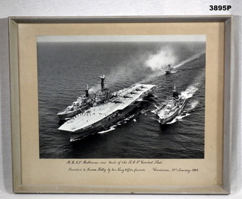
Photograph - PHOTOGRAPH RAN, FRAMED, Pre 1964
Black / white aerial photo of HMAS Melbourne with 5 aircraft on the flight deck plus 4 units of the RAN Combat fleet at sea. Photo is mounted with a fawn border with a grey wooden frame, glass front & fawn paper backing.Printed underneath photo in black ink: “H.M.A.S Melbourne and Units of the R.A.N. Combat Fleet” “Presented to Kevin Kelly by his Navy Office friends. Canberra 22nd January 1964” Written on back in pencil : “(Fate of Voyager and Melbourne) H.M.A.S. Voyager collided with H.M.A.S. Melbourne Feb 1964 - 81 lives lost” Written on back In black texta: “(Kevin Kelly)”photographs, hmas, melbourne -
 Bendigo Military Museum
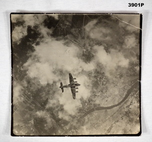
Memorabilia - PHOTOGRAPH, c.WWII
British Lancaster Bomber releasing bombs over a target. EAW is marked on the side of the bomber . Item re Frederick Gardner DAVEY DFC No 410533 RAAF. Refer Reg No 3536P for his service details.Black / white aerial photo of a British aircraft flying over land partly covered by cloud. A stick of bombs released by the aircraft is visible.On back - Handwritten in blue ink: Stick of bombs going down Stamped: Crown copyright reservedphotography, lancaster, raaf -
 Bendigo Military Museum
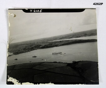
Photograph - AERIAL PHOTO, Possibly 1944
Photo in the collection of Reginald Charles Allardice No 418557 RAAF. Refer Cat No 3627.5 for his service details.B & W photo showing land and sea with one large ship and several smaller ones.On front, “T2105”. On rear in pencil,” Hospital ship Dorsetshire P.D 1 od.44 A/Z01”, stamped on rear “Crown copyright reserved”, above this as part of the stamp “A crown image M”photography, hospital ships -
 Bendigo Military Museum
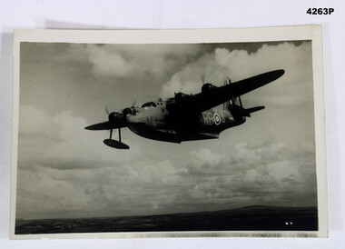
Photograph - SUNDERLAND PHOTO, Post 1943
Item in the collection of Reginald Charles Allardice No 418557 RAAF. Refer Cat No 3627.5 for his service details.Aerial B & W photo of a Sunderland Flying Boat over land. On the rear a paper is pasted to with typed writing in purple.On rear, “ BRITISH OFFICIAL PHOTOGRAPH, No CH 3210 Air Ministry photograph - crown copyright reserved. On patrol, a short Sunderland Flying Boat of the RAF Coastal Command sets out on a patrol. This particular aircraft is flown by the RAAF Squadron operating with Coastal Command The Sqd is on the 9,000 hours flying mark during its 16 months operating duty in this country”photography, sunderlands, military -
 Bendigo Military Museum
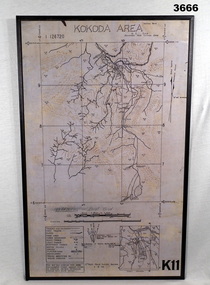
Map - MAP, KOKODA MOUNTED, 2nd Aust Field Survey Section, 4.9.1942
Map was compiled from aerial photos without ground control or inspection & with information received from Major CAMERON.Laminated map of Kokoda area on board backing with black border. Black printing on cream / fawn background. White hanging strap on back. Information ledger bottom LHS. Kokoda inset bottom RHS.Printed at top: “KOKODA AREA” Printed at bottom “RHS: K11”map, kokoda, mounted -
 Bendigo Military Museum
Photograph - PHOTOGRAPH RAAF WW2, 1939 - 1946
Item in the collection re Maxwell Matheson RAAF. History of site written on rear of photo in biro.Air photo of RAAF base. Mounted on cardboard. No. 6 service flying training school, Mallala SA. Large writer description. Photo shows very large quantity of Avro Ansons, revetments & building.On rear - "No. 6 Service Flying Training School, RAAF, Mallala"photography, aerial photos, mallala -
 Bendigo Military Museum
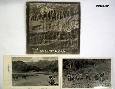
Photograph - PHOTOGRAPHS, BURMA, 26th Nov 1944
Items in the collection re Ian McLeod RWAFF, refer Cat No 2262.2.1) Aerial Sepia photograph countryside Burma. .2) Black and White photo Burma river, mountains and "kumi" natives. .3) Black and White photograph Burmese Jungle..1) “4191. 26 Nov. 44” .2) “Burmese Campaign 1944” .3) “Burmese Jungle 1944”burma, aerial, photographs -
 Bendigo Military Museum
photograph - PHOTOGRAPHS WW2, 2053) 24/10/1943; 2053.1) 17/09/1944
2053.1) Photo's "Aerial", Binder form, 4 pages, paper yellowed, photo's written on, area description under each one. B&W. 2053.2) Photo, large Aerial, B&W, "Vunakanau Plantation". Photo written on showing military positions, scale. Mosaic, Toma to Dieldimans Corner (Vunakanau) 17 Sep 1944.photography-photographs, military history - airforce, aerial -
 Bendigo Historical Society Inc.
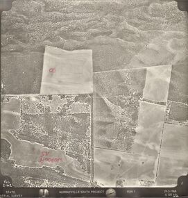
Photograph - MURRAYVILLE SOUTH PROJECT
State Aerial Survey. A set of aerial surveys related to the Murrayville South Project. Run 1. Vic. 2162. 29-2-1968. 53 photos.photograph, aerial, murrayville south project, photos, murrayville south project, state aerial survey, surveys, murrayville, photographs, photography, aerial photography -
 Bendigo Historical Society Inc.
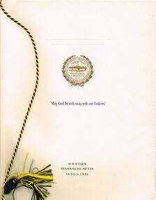
Photograph - PETHARD COLLECTION: PROMOTE VICTORIA MISSION
GEORGE PETHARD COLLECTION INCLUDING REFERENCES TO TARAXALE BREWING COMPANTY PTY LTD 6 x black and white photos of Promote Victoria mission / photos include aerial view of Boston, Heinz factory, 1957 Universal Pictures Company including American actress Lana Turner from the film The Lady Takes a Flyer / photos are inside a yellow paper brochure with a Boston seal on the front showing the history of Boston.photograph, person, george a pethard, george pethard / taraxale brewing company pty ltd / heinz factory / universal pictures company including american actress lana turne / -
 Bendigo Historical Society Inc.
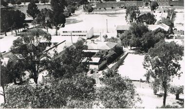
Photograph - LA TROBE UNIVERSITY BENDIGO COLLECTION BENDIGO: TEACHERS' COLLEGE BUILDINGS
A black and white photograph of an aerial view from the Lookout Tower in Rosalind Park of Bendigo Teachers' College as it was in the 1950's. In the foreground are aluminium prefabs and the old police stables. In the background is the old gaol and over to the left are the tennis courts which appear to have the sprinklers on. Although it is out of view Camp Hill Primary School is on the right of the buildings. 1950's.bendigo, education, bendigo teachers' college, la trobe university bendigo collection, collection, education, tertiary education, bendigo, bendigo teachers' college, place, buildings, bendigo gaol, tennis courts, gaol, photo, photograph, photographs, photography -
 Bendigo Historical Society Inc.
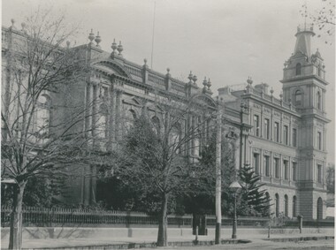
Photograph - BENDIGO SCHOOL OF MINES, c.1900
Black and white photograph showing façade of Bendigo School of Mines and the Mechanics Institute from North. Gas lamp opposite front gate. Radio aerial on roof. Photo is copy of original. On back: stamped in circle 'Royal Historical Society of Victoria, Bendigo Branch'. In black ink - '257'. In blue ink - '6', 'Now, FSP, 1204', Aeritrew?buildings, commercial, school of mines -
 Bendigo Historical Society Inc.
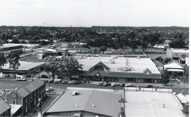
Photograph - AERIAL VIEW BENDIGO, 1995
Black and white photo: aerial view Mollison St., Jewel Shopping complex ( Noelene Wild 7/2000 ) from St. Paul's tower ? Mollison St. left to right foreground. 'B22A' black lead on rear.Peter Hyettplace, aerial view of bendigo -
 Bendigo Historical Society Inc.
Photograph - AERIAL VIEW: BENDIGO, 1995
Black and white photo: aerial view from St. Paul's church tower showing Bush's store in foreground. St. Andrew's church middle distance, Myers St. at left front to middle distance. Williamson St. left to right foreground.Peter Hyettplace, aerial view of bendigo -
 Bendigo Historical Society Inc.
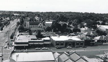
Photograph - AERIAL VIEW BENDIGO, 1995
Black and white photo: Bendigo skyline from St. Pauls, bottom left corner of Williamson St. and Myers St., Williamson St. across centre of photo. Anne Caudle centre left on skyline. Bendigo Base Hospital centre on skyline. ( Noelene Wild - 7.2000 ) In image ' Bruce's Discount Store ' ' Nissan Symes Motors ' ' Furniture Warehouse' Bendigo Bulk Carpets' The Carpet Giants 'Peter Hyettplace, aerial view of bendigo -
 Bendigo Historical Society Inc.
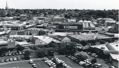
Photograph - AERIAL VIEW OF BENDIGO, 1995
Black and white photo: view of Bendigo with Mitchell St. from centre left to centre. Shows Sacred Heart Cathedral at left. Coles supermarket carpark in foreground. Dome of RSL in Pall Mall in front of trees to right. On back C 26A. Noelene Wild July 2000 ' photo by Peter Hyett 1995 from St. Paul's Myer St., Sacred Heart Cathedral at left.'Peter Hyettplace, aerial view of bendigo -
 Bendigo Historical Society Inc.
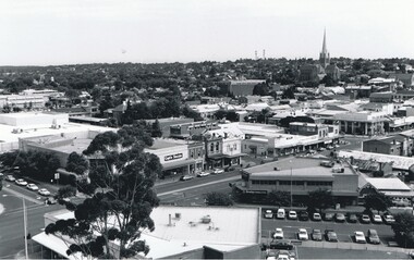
Photograph - AERIAL VIEW OF BENDIGO, 1995
Black and white photograph taken from St. Paul's, Mitchell runs from left corner. Cathedral spire in centre. T.V. towers in background. Central Deborah poppet head far left ? Ian Wild 7.2000 ' photo - Peter Hyett 1995 - ? From St. Paul's. Mitchell St. runs across photo - intersection with Edwards St. on left ';Peter Hyettcottage, miners -
 Bendigo Historical Society Inc.
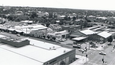
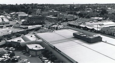
Photograph - AERIAL VIEW OF BENDIGO, 1995
Black and white photo. View from St. Paul's, tower showing Coles New World, Furniture Warehouse, Webbs Flour Mill, Library, Town Hall, Shamrock Hotel, Multistorey car park. On back 'C27A'Peter Hyettplace, aerial view of bendigo -
 Bendigo Historical Society Inc.
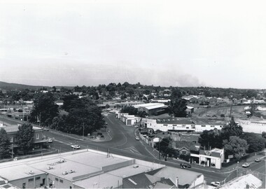
Photograph - BENDIGO RAILWAY STATION: AERIAL VIEW, 1995
... Black and white photo: aerial view looking trowards... PLACE Aerial view of bendigo bendigo railway station Peter Hyett ...Black and white photo: aerial view looking trowards Bendigo Railway Station. Mitchell st. runs across lower part of photo. Photo taken prior to building of 'Market place' shopping centre. A 16A black lead on rear.Peter Hyett 1995place, aerial view of bendigo, bendigo railway station -
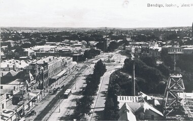 Bendigo Historical Society Inc.
Photograph - PALL MALL: HUSTLER'S ROYAL RESERVE MINE, early 1900
Black and white photo . View of Pall Mall and Hustler's Royal Reserve Mine, Bendigo, looking west. James Lerk ( 5/11/1999 ) 'View from the public offices tower, Hustler's Royal Reserve Mine, from the post office tower 'Valentine ?place, aerial view of bendigo, pall mall -
 Bendigo Historical Society Inc.
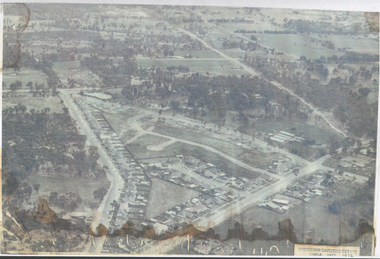
Photograph - Aerial View Sydenham Gardens Estate Circa 1972
The Sydenham gardens were set up in 1854 to provide an area of relaxation for diggers. A German, Mr Kraemer, made extensive plantings of ornamentals and fruit trees. The area expanded to 11 acres in 1865 and 25 acres in 1916. T O Hunter owned the gardens from about 1896 and initially it was used for many types of entertainment including, picnics, festivals and sporting events. It was situated off Holdsworth Road in what is now Jackass Flat. T O Hunter was a cordial manufacturer in Macrae Street, who was prominent in many sporting areas. He was President of the Bendigo Coursing Association and raced both dogs and horses. By the time he sold the gardens in 1936 to Mr Muir, he was using the gardens as grazing for his horses.Photograph: aerial view of Sydenham Gardens Estate Circa 1972 , as noted on photo Colour photo, A5 sizephoto sydenham gardens estate, aerial photo -
 Bendigo Historical Society Inc.
Photograph - AERIAL PHOTO FORTUNA VILLA
Large black and white aerial photo taken looking north, foreground Fortuna Villa, on right side site where now is St John hospital, top left garden gully oval. There are three copies (one sepia colour).bendigo, streetscape, aerial view -
Bendigo Historical Society Inc.
Photograph - FORTUNA COLLECTION: AERIAL PHOTO FORTUNA 1945
Black and white photo of Fortuna area 1945. On bottom of image printed in black : ' Fortuna - Circa 1945, approximate Scale 1:1 400, Produced from aerial photography flown 1100 hrs 7th July 1945.' Image is very blurry. -
Bendigo Historical Society Inc.
Photograph - AERIAL PHOTO OF BENDIGO
... AERIAL PHOTO OF BENDIGO... photograph of the city of Bendigo. Photograph AERIAL PHOTO OF BENDIGO ...Large black and white aerial photograph of the city of Bendigo.bendigo, streetscape, aerial view