Showing 294 items
matching clear creek
-
 El Dorado Museum Association Inc.
Photograph - Digital Image
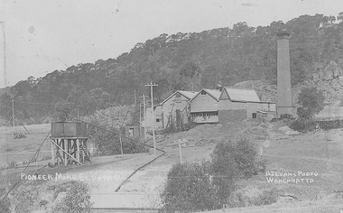
... the junction of Clear and Reid's Creeks. From 6,800,000 cubic yards... mine was established by diverting Reid's Creek at a cost of £25 ...Cocks Pioneer Power Station No 1. Cocks Pioneer Electric Gold & Tin Mine Company was formed in 1899. The company's first power station, located at the eastern end of the valley began operating with its 340 Kilowatt steam-powered generator. By 1909, from 2 500 000 cubic yards worked, reported recovery was 17 284 ounces of gold and 224 tons of tin ore. By 1909, Cocks Pioneer’s power plant had become inadequate and uneconomical. The barge was floated downstream about a mile, but lost time caused the operations to cease. Following testing, a new mine was established by diverting Reid's Creek at a cost of £25 000. Settling dams were built, one of which held 1 935 900 cubic feet. Sold earth banks, built against a wall of stringy bark saplings constructed and laced with vertical props, were built. In 1914, the company was reformed as Cock’s Pioneer Gold and Tin Mines NL, another power station was constructed at the western end of the township, near the junction of Clear and Reid's Creeks. From 6,800,000 cubic yards of material processed, the returns were 64 397 ounces of gold and 855 ton of tin. Cocks Pioneer mine then moved the barge downs stream and continued sluicing. In 1929 Cocks Pioneer Electric Gold and Tin Mining Company ceased operations due to a drop in values. Cock’s Pioneer Gold and Tin Mines NL carried on large-scale hydraulic sluicing operations until 1941. Handrwitten on right side of image: PIONEER MINE ELDORADO Handwritten on left side of image: AJ EVANS PHOTO / WANGARATTAmines, mining, gold, tin, gold mining, tin mining, sluicing, hydraulic mining, energy, power station, cocks pioneer, el dorado, eldorado -
 El Dorado Museum Association Inc.
Photograph - Digital Image
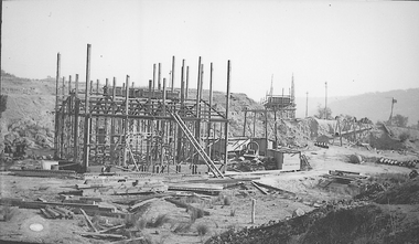
... the junction of Clear and Reid's Creeks. From 6,800,000 cubic yards... mine was established by diverting Reid's Creek at a cost of £25 ...Construction of New Barge, Cocks Pioneer. Cocks Pioneer Electric Gold & Tin Mine Company was formed in 1899. The company's first power station, located at the eastern end of the valley began operating with its 340 Kilowatt steam-powered generator. By 1909, from 2,500,000 cubic yards worked, reported recovery was 17,284 ounces of gold and 224 tons of tin ore. By 1909, Cocks Pioneer’s power plant had become inadequate and uneconomical. The barge was floated downstream about a mile, but lost time caused the operations to cease. Following testing, a new mine was established by diverting Reid's Creek at a cost of £25 000. Settling dams were built, one of which held 1,935,900 cubic feet. Sold earth banks, built against a wall of stringy bark saplings constructed and laced with vertical props, were built. In 1914, the company was reformed as Cock’s Pioneer Gold and Tin Mines NL, another power station was constructed at the western end of the township, near the junction of Clear and Reid's Creeks. From 6,800,000 cubic yards of material processed, the returns were 64,397 ounces of gold and 855 ton of tin. Cocks Pioneer mine then moved the barge downs stream and continued sluicing. In 1929 Cocks Pioneer Electric Gold and Tin Mining Company ceased operations due to a drop in values. Cock’s Pioneer Gold and Tin Mines NL carried on large-scale hydraulic sluicing operations until 1941. mines, mining, gold, tin, gold mining, tin mining, sluicing, barge, construction, cocks pioneer, el dorado, eldorado -
 El Dorado Museum Association Inc.
Photograph - Digital Image
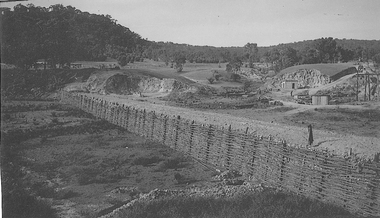
... the junction of Clear and Reid's Creeks. From 6,800,000 cubic yards... mine was established by diverting Reid's Creek at a cost of £25 ...Creek Diversion, Cocks Power. Cocks Pioneer Electric Gold & Tin Mine Company was formed in 1899. The company's first power station, located at the eastern end of the valley began operating with its 340 Kilowatt steam-powered generator. By 1909, from 2 500 000 cubic yards worked, reported recovery was 17 284 ounces of gold and 224 tons of tin ore. By 1909, Cocks Pioneer’s power plant had become inadequate and uneconomical. The barge was floated downstream about a mile, but lost time caused the operations to cease. Following testing, a new mine was established by diverting Reid's Creek at a cost of £25 000. Settling dams were built, one of which held 1 935 900 cubic feet. Sold earth banks, built against a wall of stringy bark saplings constructed and laced with vertical props, were built. In 1914, the company was reformed as Cock’s Pioneer Gold and Tin Mines NL, another power station was constructed at the western end of the township, near the junction of Clear and Reid's Creeks. From 6,800,000 cubic yards of material processed, the returns were 64 397 ounces of gold and 855 ton of tin. Cocks Pioneer mine then moved the barge downs stream and continued sluicing. In 1929 Cocks Pioneer Electric Gold and Tin Mining Company ceased operations due to a drop in values. Cock’s Pioneer Gold and Tin Mines NL carried on large-scale hydraulic sluicing operations until 1941. mines, mining, gold, tin, gold mining, tin mining, creeks, cocks pioneer, el dorado, eldorado -
 El Dorado Museum Association Inc.
Photograph - Digital Image
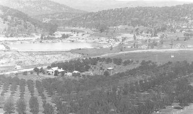
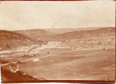
... mine was established by diverting Reid's Creek at a cost of £25... of Clear and Reid's Creeks. From 6,800,000 cubic yards of material ...C Rankins Almond Orchard & Cocks Pioneer Pond, 1930s. Cocks Pioneer Electric Gold & Tin Mine Company was formed in 1899. The company's first power station, located at the eastern end of the valley began operating with its 340 Kilowatt steam-powered generator. By 1909, from 2 500 000 cubic yards worked, reported recovery was 17 284 ounces of gold and 224 tons of tin ore. By 1909, Cocks Pioneer’s power plant had become inadequate and uneconomical. The barge was floated downstream about a mile, but lost time caused the operations to cease. Following testing, a new mine was established by diverting Reid's Creek at a cost of £25 000. Settling dams were built, one of which held 1 935 900 cubic feet. Sold earth banks, built against a wall of stringy bark saplings constructed and laced with vertical props, were built. In 1914, the company was reformed as Cock’s Pioneer Gold and Tin Mines NL, another power station was constructed at the western end of the township, near the junction of Clear and Reid's Creeks. From 6,800,000 cubic yards of material processed, the returns were 64 397 ounces of gold and 855 ton of tin. Cocks Pioneer mine then moved the barge downs stream and continued sluicing. In 1929 Cocks Pioneer Electric Gold and Tin Mining Company ceased operations due to a drop in values. Cock’s Pioneer Gold and Tin Mines NL carried on large-scale hydraulic sluicing operations until 1941. mines, mining, farms, farming, almonds, sluicing, rankins, cocks pioneer, el dorado, eldorado -
 El Dorado Museum Association Inc.
Photograph - Digital Image
... mine was established by diverting Reid's Creek at a cost of £25... mine was established by diverting Reid's Creek at a cost of £25 ...Cocks Pioneer, East El Dorado, early 1920s. Cocks Pioneer Electric Gold & Tin Mine Company was formed in 1899. The company's first power station, located at the eastern end of the valley began operating with its 340 Kilowatt steam-powered generator. By 1909, from 2 500 000 cubic yards worked, reported recovery was 17 284 ounces of gold and 224 tons of tin ore. By 1909, Cocks Pioneer’s power plant had become inadequate and uneconomical. The barge was floated downstream about a mile, but lost time caused the operations to cease. Following testing, a new mine was established by diverting Reid's Creek at a cost of £25 000. Settling dams were built, one of which held 1 935 900 cubic feet. Sold earth banks, built against a wall of stringy bark saplings constructed and laced with vertical props, were built. In 1914, the company was reformed as Cock’s Pioneer Gold and Tin Mines NL, another power station was constructed at the western end of the township, near the junction of Clear and Reid's Creeks. From 6,800,000 cubic yards of material processed, the returns were 64 397 ounces of gold and 855 ton of tin. Cocks Pioneer mine then moved the barge downs stream and continued sluicing. In 1929 Cocks Pioneer Electric Gold and Tin Mining Company ceased operations due to a drop in values. Cock’s Pioneer Gold and Tin Mines NL carried on large-scale hydraulic sluicing operations until 1941. mines, mining, gold, gold mining, cocks pioneer, sluicing, el dorado, eldorado -
 El Dorado Museum Association Inc.
Photograph - Digital Image
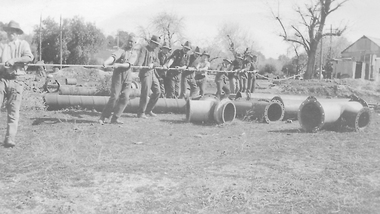
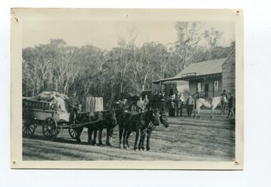
... the junction of Clear and Reid's Creeks. From 6,800,000 cubic yards... the junction of Clear and Reid's Creeks. From 6,800,000 cubic yards ...Moving Cocks Pioneer Barge, c1930s. Cocks Pioneer Electric Gold & Tin Mine Company was formed in 1899. The company's first power station, located at the eastern end of the valley began operating with its 340 Kilowatt steam-powered generator. By 1909, from 2,500,000 cubic yards worked, reported recovery was 17,284 ounces of gold and 224 tons of tin ore. By 1909, Cocks Pioneer’s power plant had become inadequate and uneconomical. The barge was floated downstream about a mile, but lost time caused the operations to cease. Following testing, a new mine was established by diverting Reid's Creek at a cost of £25,000. Settling dams were built, one of which held 1,935,900 cubic feet. Sold earth banks, built against a wall of stringy bark saplings constructed and laced with vertical props, were built. In 1914, the company was reformed as Cock’s Pioneer Gold and Tin Mines NL, another power station was constructed at the western end of the township, near the junction of Clear and Reid's Creeks. From 6,800,000 cubic yards of material processed, the returns were 64,397 ounces of gold and 855 ton of tin. Cocks Pioneer mine then moved the barge downs stream and continued sluicing. In 1929 Cocks Pioneer Electric Gold and Tin Mining Company ceased operations due to a drop in values. Cock’s Pioneer Gold and Tin Mines NL carried on large-scale hydraulic sluicing operations until 1941. mines, mining, gold, tin, gold mining, tin mining, men, miners, barge, sluicing, hydraulic, cocks pioneer, el dorado, eldorado -
 El Dorado Museum Association Inc.
Photograph (item) - Digital Image
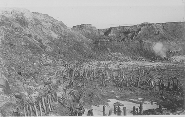
... the junction of Clear and Reid's Creeks. From 6,800,000 cubic yards... the junction of Clear and Reid's Creeks. From 6,800,000 cubic yards ...Cocks Pioneer old mine timbers. Cocks Pioneer Electric Gold & Tin Mine Company was formed in 1899. The company's first power station, located at the eastern end of the valley began operating with its 340 Kilowatt steam-powered generator. By 1909, from 2,500,000 cubic yards worked, reported recovery was 17,284 ounces of gold and 224 tons of tin ore. By 1909, Cocks Pioneer’s power plant had become inadequate and uneconomical. The barge was floated downstream about a mile, but lost time caused the operations to cease. Following testing, a new mine was established by diverting Reid's Creek at a cost of £25 000. Settling dams were built, one of which held 1,935,900 cubic feet. Sold earth banks, built against a wall of stringy bark saplings constructed and laced with vertical props, were built. In 1914, the company was reformed as Cock’s Pioneer Gold and Tin Mines NL, another power station was constructed at the western end of the township, near the junction of Clear and Reid's Creeks. From 6,800,000 cubic yards of material processed, the returns were 64,397 ounces of gold and 855 ton of tin. Cocks Pioneer mine then moved the barge downs stream and continued sluicing. In 1929 Cocks Pioneer Electric Gold and Tin Mining Company ceased operations due to a drop in values. Cock’s Pioneer Gold and Tin Mines NL carried on large-scale hydraulic sluicing operations until 1941. mining, gold, tin, open cut, gold mining, tin mining, cocks pioneer, el dorado, eldorado -
 El Dorado Museum Association Inc.
Photograph (item) - Digital Image
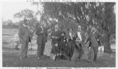
... the junction of Clear and Reid's Creeks. From 6,800,000 cubic yards... mine was established by diverting Reid's Creek at a cost of £25 ...Image of Cocks Pioneer Gold & Tin Mines NL directors with Mrs Molly Moline and children, Dorothy and Geoff. Taken at Sherwood - the mine manager's residence. (1914) Cocks Pioneer Electric Gold & Tin Mine Company was formed in 1899. The company's first power station, located at the eastern end of the valley began operating with its 340 Kilowatt steam-powered generator. By 1909, from 2,500,000 cubic yards worked, reported recovery was 17,284 ounces of gold and 224 tons of tin ore. By 1909, Cocks Pioneer’s power plant had become inadequate and uneconomical. The barge was floated downstream about a mile, but lost time caused the operations to cease. Following testing, a new mine was established by diverting Reid's Creek at a cost of £25 000. Settling dams were built, one of which held 1,935,900 cubic feet. Sold earth banks, built against a wall of stringy bark saplings constructed and laced with vertical props, were built. In 1914, the company was reformed as Cock’s Pioneer Gold and Tin Mines NL, another power station was constructed at the western end of the township, near the junction of Clear and Reid's Creeks. From 6,800,000 cubic yards of material processed, the returns were 64,397 ounces of gold and 855 ton of tin. Cocks Pioneer mine then moved the barge downs stream and continued sluicing. In 1929 Cocks Pioneer Electric Gold and Tin Mining Company ceased operations due to a drop in values. Cock’s Pioneer Gold and Tin Mines NL carried on large-scale hydraulic sluicing operations until 1941. "COX PIONEER MINE DIRECTORS" top "GEOFF DOR (unclear) TED SHACKLE" bottommine, gold, tin, gold mining, tin mining, cockatoos, sluicing, men, women, children, cocks pioneer, el dorado, eldorado -
 El Dorado Museum Association Inc.
Photograph - Digital Image
... mine was established by diverting Reid's Creek at a cost of £25... of Clear and Reid's Creeks. From 6,800,000 cubic yards of material ...Riffle Boards on Barge, c1934. In sluicing, riffles are used to trap heavier gold particles as water washes over them. Cocks Pioneer Electric Gold & Tin Mine Company was formed in 1899. The company's first power station, located at the eastern end of the valley began operating with its 340 Kilowatt steam-powered generator. By 1909, from 2 500 000 cubic yards worked, reported recovery was 17 284 ounces of gold and 224 tons of tin ore. By 1909, Cocks Pioneer’s power plant had become inadequate and uneconomical. The barge was floated downstream about a mile, but lost time caused the operations to cease. Following testing, a new mine was established by diverting Reid's Creek at a cost of £25 000. Settling dams were built, one of which held 1 935 900 cubic feet. Sold earth banks, built against a wall of stringy bark saplings constructed and laced with vertical props, were built. In 1914, the company was reformed as Cock’s Pioneer Gold and Tin Mines NL, another power station was constructed at the western end of the township, near the junction of Clear and Reid's Creeks. From 6,800,000 cubic yards of material processed, the returns were 64 397 ounces of gold and 855 ton of tin. Cocks Pioneer mine then moved the barge downs stream and continued sluicing. In 1929 Cocks Pioneer Electric Gold and Tin Mining Company ceased operations due to a drop in values. Cock’s Pioneer Gold and Tin Mines NL carried on large-scale hydraulic sluicing operations until 1941. mines, mining, gold, gold mining, barge, riffles, sluicing, men, cocks pioneer, el dorado, eldorado -
 Orbost & District Historical Society
black and white photograph, 1884?
... the property; he cleared and drained Icy Creek and constructed... the property; he cleared and drained Icy Creek and constructed ...James Alexander Robertson was born 14th June, 1855, at Pentridge. the Coburg area which was known as Pentridge at the time, and prior to the building of the gaol. His parents were James Thomson Robertson and Esther (nee Hale), At age 20 James became the first selector on the Snowy River at Lochend. He took up Lots 1, 2 and 3, in the Parish of Newmerella in 1875; with his selection being ratified on May 1st, 1876. The selection included hill and river flat land in the area near where Icy Creek enters the Snowy River. James gradually improved and farmed the property; he cleared and drained Icy Creek and constructed the first known flood-gate on the Snowy River. To meet his farming commitments he supplemented his income by working on the construction and maintenance of roads and drains in the Newmerella area. He gained a contract with the Bairnsdale Shire council to construct the first road cutting down Burn’s Hill at Newmerella. His tender was for £16 ($32), and it took him, with four others, two months to complete the contract. He was single, and, after his untimely death at aged 29, in 1884, his parents and surviving unmarried sisters and brothers moved from Sarsfield to take over his selection at Lochend. (more information Newsletter April 2013)James Robertson was the first selector of land at Lochend, Orbost.A small black / white portrait photograph, oval shaped with a white background. It is of a middle-aged man with a full beard and moustache.on front at bottom - typed in black -:"James Alexander Robertson, Late of Lochend, Snowy River"robertson-james-alexander lochend-robertson -
 The Beechworth Burke Museum
Animal specimen - Spotted Pardalote, Trustees of the Australian Museum, 1860-1880
The spotted pardalote is the smallest of all Australian birds. It has a tendency to nest in a long horizontal tunnel, often dug into the soil of creek banks, the embankments of railway cuttings, and quarries. Its call is characterised by a very clear and repetitive double "ding". The spotted pardalote is common in woodlands and eucalypt forest areas in Australia. This specimen is part of a collection of almost 200 animal specimens that were originally acquired as skins from various institutions across Australia, including the Australian Museum in Sydney and the National Museum of Victoria (known as Museums Victoria since 1983), as well as individuals such as amateur anthropologist Reynell Eveleigh Johns between 1860-1880. These skins were then mounted by members of the Burke Museum Committee and put-on display in the formal space of the Museum’s original exhibition hall where they continue to be on display. This display of taxidermy mounts initially served to instruct visitors to the Burke Museum of the natural world around them, today it serves as an insight into the collecting habits of the 19th century.This specimen is part of a significant and rare taxidermy mount collection in the Burke Museum. This collection is scientifically and culturally important for reminding us of how science continues to shape our understanding of the modern world. They demonstrate a capacity to hold evidence of how Australia’s fauna history existed in the past and are potentially important for future environmental research. This collection continues to be on display in the Museum and has become a key part to interpreting the collecting habits of the 19th century. One of Australia's smallest native birds, the male spotted pardalotte is covered with small, distinct white spots. Males have a pale eyebrow, a yellow throat and a red rump. Females are similar but have less-distinct markings. 10060 comprises of one male and one female. This specimen stands upon a wooden platform and has an identification tag tied around its legLabel: 14a. / Spotted Diamond Bird / See Catalogue, page 9. /taxidermy mount, cancel, taxidermy, burke museum, beechworth, australian museum, bird, spotted pardalote -
 The Beechworth Burke Museum
Audio - Oral History, Jennifer Williams, Mr Herbert McFeeters, 4 May 2000
Herbert McFeeters as born in Wooragee Creek in 11th July 1905. Mr McFeeters would walk to school in Beechworth by foot, about 3.5 miles through the hills. It would take him and his siblings one hour to get to school. Mr McFeeters worked at the local tannery from the age of 14 for 11 years. After which he worked for himself, farming cattle and selling milk around the region. Mr McFeeters bought land from the Crown, who were selling lands after many miners had left the region. Mr McFeeters recalls the Chinese community that remained the Beechworth area and the social activities in the town, including the pictures, football games and Harvest Festivals. This oral history recording was part of a project conducted by Jennifer Williams in the year 2000 to capture the everyday life and struggles in Beechworth during the twentieth century. This project involved recording seventy oral histories on cassette tapes of local Beechworth residents which were then published in a book titled: Listen to what they say: voices of twentieth century Beechworth. These cassette tapes were digitised in July 2021 with funds made available by the Friends of the Burke. Mr McFeeters oral history provides detail of life in rural Victoria during the early 20th Century. Mr McFeeters describes his early childhood and working life, including details of the social activities This oral history recording was part of a project conducted by Jennifer Williams in the year 2000 to capture the everyday life and struggles in Beechworth during the twentieth century. This project involved recording seventy oral histories on cassette tapes of local Beechworth residents which were then published in a book titled: Listen to what they say: voices of twentieth century Beechworth. These cassette tapes were digitised in July 2021 with funds made available by the Friends of the Burke. This is a digital copy of a recording that was originally captured on a cassette tape. The cassette tape is black with a horizontal white strip and is currently stored in a clear flat plastic rectangular container. It holds up 40 minutes of recordings on each side.Mr Herbert McFeeters /listen to what they say, beechworth, oral history, burke museum, herbert mcfeeters, wooragee creek, reid's creek -
 The Beechworth Burke Museum
Audio - Oral History, Jennifer Williams, Evelyn Jensen, 13th April 2000
Miss Evelyn Jensen was born in 1908 near Mytleford Road in Beechworth. Miss Jensen was a twin but she also had twelve brothers and sisters. Miss Jensen went to school when she was nine years old but did not enjoy it. Her father was a nozzleman and had a role in finding and collecting gold. More specifically, a nozzleman operated a steel barrel with an interchangeable brass nozzle that sprayed high pressure water onto rock and similar surfaces. This broke down the surface for gold to be found. Unfortunately, when he began most of the gold was already gone. Miss Jensen's mother died when Miss Jensen was sixteen. As a result, Miss Jensen had to take care of the children and run the house. This included looking after a few months old baby. Her father was away at work most days so all of the responsibility fell on her. Her grandmother was present but she was too old to help Miss Jensen. Miss Jensen and her family lived a very long way from the main town and often had to carry kerosene tins full of water half a mile to their house. This was because they have no access to water at their home. This lack of water also meant they had to either bathe in the creek or carry the water back home for a bath. On wash day, they washed their clothes in the creek too. Miss Jensen never married but continued to provide for her family. She spent her days gardening and cooking. They did not have much money so gardening was a way that they provided food for themselves. This oral history recording was part of a project conducted by Jennifer Williams in the year 2000 to capture the everyday life and struggles in Beechworth during the twentieth century. This project involved recording seventy oral histories on cassette tapes of local Beechworth residents which were then published in a book titled: Listen to what they say: voices of twentieth century Beechworth. These cassette tapes were digitised in July 2021 with funds made available by the Friends of the Burke.Miss Jensen's oral history is significant because it demonstrates the struggles of living remotely during this early part of the twentieth century. When Miss Jensen's mother died, she had to take on a lot of responsibility and did not have much support. This history sheds light on these struggles of being a young caregiver but it also gives details on how large families lived in isolated places. An example of this is the way that Miss Jensen often had to do the washing in the creek because that was the only place there was running water. In addition, Miss Jensen's story is significant because her father was a nozzleman. It indicates one of the processes was used to find gold. This oral history account is socially and historically significant as it is a part of a broader collection of interviews conducted by Jennifer Williams which were published in the book 'Listen to what they say: voices of twentieth-century Beechworth.' While the township of Beechworth is known for its history as a gold rush town, these accounts provide a unique insight into the day-to-day life of the town's residents during the 20th century, many of which will have now been lost if they had not been preserved.This is a digital copy of a recording that was originally captured on a cassette tape. The cassette tape is black with a horizontal white strip and is currently stored in a clear flat plastic rectangular container. It holds up 40 minutes of recordings on each sideEvelyn Jensen /mytleford road, beechworth, three mile creek, three mile beechworth, twin, nozzleman, goldrush, gold rush, work, mother, young mother, children, siblings, baby, grandmother, father, isolation, bush, water, watertanks, kerosene tins, wash day, bath day, creek, gardening, provide, poor, money, oral history, twentieth century, recording, story -
 Orbost & District Historical Society
bottle, Probably WW11
Joseph Bosisto was a Yorkshireman who had qualified as a Pharmacist in Leeds and London. He arrived in Adelaide in 1848 at the age of 21. In 1851 he moved to Victoria in search of gold, but instead opened a pharmacy in Richmond, where he built a laboratory to investigate the chemical and medicinal properties of Australian plants. As a result of the collaboration with von Meuller the essential oil industry of Australia began in 1852, when Bosisto commenced operations in a small, rudely constructed still at Dandenong Creek, Victoria, using the leaves of a form of E. radiata (then known as E. amygdalina) which grew profusely in the district. Bosisto soon built other distilleries at Emerald, Menzies Creek and Macclesfield. World War II soldiers packed it in their mess kits to keep foot fungus in the tropics at bay. Small clear glass Eucalyptus Oil bottle with metal screw lid and large label on front.Front Label - War Time Pack Back - This bottle remains property of J Bosisto &Co Pty Ltd Richmond Victoria Bottom-F1196bottle eucalyptus-oil bosisto-joseph -
 Ringwood and District Historical Society
Map - Public Land Sale by Thomas Ham, 2000 Acres for Sale - Crown Sections 20, 23, 24 - Ringwood, Victoria - 1855
Two 1850s surveyor's maps on cardboard backing showing area from Melbourne extending East beyond Bulleen and Nunawading. Detailed description of lots for sale and navigational directions to the property from Richmond by Thomas Ham, Victorian public servant, map maker, publisher, lithographer and original Ringwood land owner. Inset map enlarging area between Yarra River and Dandenong Creek, with southern boundary of allotments later forming part of Oban Road, North Ringwood.TRANSCRIPT: "This really valuable Property is now offered to the public for sale, in lots to suit purchasers at the Iow rate of £1 per Acre for 80 acres and upwards, and £1.10s per Acre for any smaller portion. Terms of payment Half Cash, Balance in 6 and 12 months, bearing 8 per cent interest. The Estate is well wooded with Gum, Cherry Tree and Stringy Bark, with Wattle in the valleys of the several creeks. Every lot is Staked and Trenched at the corners marked on the Plan thus - The Surveyor has carefully sub-divided the Property, in order to give every Farm a Creek for Water, Valley for Cultivation, and Hills for House and Grass Paddock. The ROADS have been very carefully laid out so as to give a firm, well drained, and nearly level road to each Homestead. Intending purchasers can readily find the property by the following directions, viz: Start from Richmond Bridge, at Hawthorne, then take the left-hand road to KEW. When at the "Woodman Inn", take the Cotham Road to the right, bearing due east, keep this Road, passing Trainor's "White Horse" Inn, and before you leave the fences, you will see calico bills (see margin) nailed to the Trees on the bush track leading to the Upper Yarra country, follow the Bills till you come to the SOUTH boundary line of the Property, which bears East and West (see Plan) where you will see Bills nailed up "THIS PROPERTY FOR SALE, etc." The Bills from Town lead direct to where Mr. Jull is erecting his Store, and arrangements have been made with him to show the lots to intending purchasers free of charge. At the respective corners of the lots the Bills are nailed up double, with numbers to denote the lot, and that the corner stake is adjacent. Any parties wishing to proceed to the property by way of BULLEEN will find Bills nailed on the Trees, commencing at the NEW INN, at "Wilson's Slip Rail." Keep this Track till you come to the Log Bridge, over the Deep Creek at Bloxhome's Paddock; go through the land now being cleared; keep the track over the hill till you come to an Iron House, you will then be on the property, which Iies to the North and East as per Plan. Follow the Bills till you come to Mr. Jull's Store, etc. etc. Further particulars can be had from the Agent for the Property. THOMAS HAM. " -
 Orbost & District Historical Society
black and white photograph, late 19th century - early 20th century
This is a photograph of Alice Swallow's hotel at Cabbage Tree. The settlement of Cabbage Tree Creek is located on the Princes Highway, 27 km east of Orbost in East Gippsland. The first white settler arrived in the valley in 1887 cutting a dray track from Marlo to the south-west. Several families cleared the alluvial flats, growing maize, peas and beans and raising pigs, cattle and sheep. Later the farmers milked cows, sending cream to Orbost. In the late 1890s, small quantities of alluvial gold were found in the creek. A school commenced classes in 1913, but enrolment was small and at times the school operated part time with several other small schools in the area. The school building served as a hall for the district. From the 1920s the Cabbage Tree Hotel catered to drivers on the improved Princes Highway. (info. from Victorian Places)This is a pictorial record of Cabbage Tree, East Gippsland in the late 20th century. It shows a building that no longer exists.A black / white photograph of a small, single - storey wooden building in a bush setting. There are people standing in front of the building with a horse and wagon nearby. In the foreground is a wagon with four horses hitched to it and the driver seated behind the horses. -
 Orbost & District Historical Society
black and white photograph, late 19th century - early 20th century
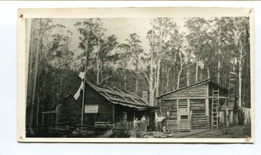
Peter Jensen came to Martin's Creek (35 miles north of Orbost) in 1890 having been told that Martin's Creek would be on the railway line. He was a cooper who made the casks from silver wattles. He cleared the area for farming and then built an accommodation house, Danebo., which was well used by travellers to Bonang and Bendoc. . Gippsland was a relatively less developed part of Victoria in the nineteenth century. Danebo Hotel, Martin’s Creek, would have been an important stopping point for travellers to Bonang and Bendoc. The hotel is no longer standing A black / white photograph of a timber building - a house and another building at an angle. There are three people standing in front - a man. woman and child. On the left is a flag on a mast. In the background is bush.danebo-hotel-martins-creek jensen-peter -
 Orbost & District Historical Society
black and white photograph, 1920s -1930s
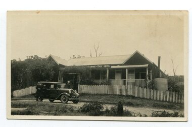
The Cabbage Tree Creek township was originally established to support the booming timber industry of the mid 20th century. Five timber mills worked full time supporting the families that were drawn to the area's wealth of natural resources. The settlement of Cabbage Tree Creek is located on the Princes Highway, 27 km east of Orbost in East Gippsland. The first white settler arrived in the valley in 1887 cutting a dray track from Marlo to the south-west. Several families cleared the alluvial flats, growing maize, peas and beans and raising pigs, cattle and sheep. Later the farmers milked cows, sending cream to Orbost. In the late 1890s, small quantities of alluvial gold were found in the creek. A school commenced classes in 1913, but enrolment was small and at times the school operated part time with several other small schools in the area. The school building served as a hall for the district. From the 1920s the Cabbage Tree Hotel catered to drivers on the improved Princes Highway. (info. from Victorian Places)This is a pictorial record of Cabbage Tree, East Gippsland in the late 20th century. It shows a building that no longer exists.A small black / white photograph of a single storey timber building. On a sign below the roof is "Cabbage Tree Hotel". The hotel is surrounded by a wooden picket fence. A man and woman are standing on either side of a motor car parked on the roadway in front of the building.on back - on label - Cabbage Tree Hotelcabbage-tree-hotel -
 Kiewa Valley Historical Society
Folder - Early Photos of Mt Beauty
Mt Beauty township was built during the 1950's to house the employees of the State Electricity Commission working on the Kiewa Hydro Electric Scheme. After the completion of the Kiewa Hydro Electric Scheme many houses were sold and the public buildings handed over to the Alpine Shire. Mt Beauty has always been a tourist destination especially with its proximity to the ski fields at Falls Creek.This folder contains many early photos of Mt Beauty showing the construction town during its development during the Kiewa Hydro Electric Scheme and its early days of tourism. A3 size black plastic folder with clear plastic sleeves holding early black & white photos of Mt Beauty township. Also included are: 1. 3 foolscap pages -Nov., 1953 Kiewa Hydro-Electric Scheme Progress. 2. SECV Drawing Plan (No. K6242) of Mt Beauty House - 3 angles and floor plan, English Pre-cut Type 3B.ILA with note that all houses with prefix 3B are similar. 3. Orange, black and white pamphlet "Welcome to Kiewa" 4. Tourist postcard 'fold-up' of 11 postcards "Mt Beauty and the Kiewa Scheme, Victoria 5. Drawing Plan of 'Mt Beauty Housing. Use of Prefabricated Cubicles for Houses. Type C.1 6. Drawing Plan of 'Kiewa Scheme Mt Beauty Housing Type "G". 7. 5 pages on "Twelve Tips on Caring for Old Buildings 8. Booklet advertising Mt Beauty housing for sale including activities available in the area. (1960's) 9. List of Photos from SECV held by KVHS Some photos have handwritten labels mt beauty. secv. kiewa hydro electric scheme.tourism. housing. construction town. falls creek. -
 Kiewa Valley Historical Society
Folder - Clare Roper No. 1, Items of Interest
Clare Roper was a resident of the Kiewa Valley and belonged to the Kiewa Valley Historical Society.Clare Roper collected and collated items of historical interest for the Kiewa Valley Historical Society. Orange plastic with clear front cover and 10 clear sleeves / pages. Includes - SECV brochure "Visit Victoria's beautiful Upper Kiewa Valley" Newspaper Article 30 July 1986 - "Ory Frehauf 'Father' - 61 year old Russian has lived at Falls Creek for 32 years" and an article - "Snow shoeing at Falls Creek" Newspaper Article 4 Nov. 1989 - Audrey Edmondson at Mt Beauty Pondage & Lions Clubclare roper; scrap book; -
 Kiewa Valley Historical Society
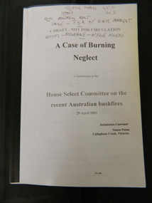
Booklet - Australian Bushfires, A Case of Burning Neglect, 2003
In early 2003 bush fires covered much of North East Victoria. Submissions were requested by the 'House Select Committee' for comment on various aspects of the fire in order to help prevent bush fires in the future.Simon Paton is a local resident of the Kiewa Valley where the bush fires occurred. His report includes other residents statements on various aspects of the fire and its prevention and impact on the local area. A booklet of 45 A4 pages with clear plastic cover bounded by black plastic spine. A Submission to the House select Committee on the recent Australian bushfires 29 April 2003. Submission Convenor: Simon Paton, Callaghans Creek, VictoriaThroughout in black pen markings and notes.2003 bush fires; north east victoria -
 Eltham District Historical Society Inc
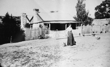
Negative - Photograph, Mary Jane Smart (nee Bailey) ouside the Smart family home in Bridge Street, Eltham, c.1915
Located on the north side of Bridge Street at the intersection with Bolton Street, facing Bolton Street (now part of present day Brisbane Street and occupied by the Kitchen Design Centre). Show's an original early settler's cottage in Bridge Street. The cottage was built by Mrs Mary Jane Smart's parents, Edwin Bailey and Jane (nee Matthews). Mary Jane Smart was born in the cottage. She married an Englishman, Alexander Wilson Smart who disappeared to Western Australia in the early 1900s in search of gold. He ultimately married again in W.A., committing bigamy and then committed murder and was hung in 1911. This photo was taken c.1903 not long before both Mrs Bailey and her grand daughter both passed away. Jane Bailey died 2 Dec. 1904 and Mary Jane Smart and Ruby Jane Bertha Smart died July 1903 are all buried in Eltham Cemetery. SMART'S HOME AT ELTHAM. HIS WIFE AND SONS. In a little bush cottage surrounded by tall gum trees, through which appear glimpses of a willow fringed creek, of road ways hedged by masses of snowy flowering hawthorn, of growing crops and vividly green grazing paddocks, lives Mrs. Smart, the lawful wife of the man who is now in the hands of the police of Western Australia on suspicion of having committed a dreadful crime. Here, about half a mile out of the picturesque village of Eltham, she was born, and has lived her whole life — about 50 years. Smart himself lived here till the time when many years ago, the "lure of gold" got into his blood and he cleared out to Western Australia, to follow the digging rushes, gradually becom ing more and more estranged, till at length all communication ceased and be became lost to his wife and children. "I did not want him to go away," said Mrs. Smart, "because I had heard of so many men who had forgotten their homes in the excite ment of gold seeking, and of many others who died unknown and uncared for. But he would go, and when I saw his mind was set on it I placed no obstacles in his way. My parents built and lived in this cottage, where I was born, and they died in it. When I grew up I met my husband, a young Englishman, and married him. His name is Alexander, not Alfred, and his age is 52. We were very happy here, and although we were not well off we were comfortable, for he was a steady, sober, industrious man and had constant employment. He was just a manual worker, but could turn his hand to anything. We had five children, but one died. Four sons grew up in this little cottage. Thus three generations lived in it, somewhat unusual in an Australian bush home, I think. My eldest son is married and has a family; one is in Western Australia— not with his father— another is away working for him self, and one (indicating a young man by her side) has always stuck to his mother. He is my sole support, and he is as good to me now as his father once was. Yes, his father was a good, home-loving man in our younger days. He was fond of his children and was highly respected in these parts.' "It is fifteen years since my husband went away first. He had then been work ing for the Metropolitan Board of Works, and was engaged in the tunnel under the Yarra near Queen's-bridge when it col-lapsed. After he went to the West he sent me money regularly and wrote constantly. He came home three times — twice for a week or two at a time, the third time, eight years ago, when the Eitham railway was nearing completion. I induced him to stay till the railway opened, and he re-mained with me several months. I tried to get him to leave the West and settle down in his home, but he would not; he seemed restless and anxious to be off. One day when we were in Collingwood together he left me, saying he wanted to see what boats were going West. I implored him not to go away, and he said he would see. However, he returned to me soon after wards and said he had taken his ticket and would go by the next boat, and he went. For a year he wrote at irregular intervals, and then his letters ceased and I heard no more of him. For seven years I have not known whether he was alive or dead. Before that time my two sons in Western Australian used to see him some times, though they did not live with him; they used to tell me in their letters that he was well. It was a hard blow to be forgotten by him, but as my sons grew up I became more reconciled, and now I seem to look back at my life with him as some thing that happened a long time ago and is only a memory. Of his life and doings in Western Australia I know nothing. The last time I heard of him he was working in a foundry at Midland Junction. He was at Cue working on the railway when it opened there, and he caught the fever, but all that time he sent me money. When he returned the first time he took our eldest son with him, and the other boy followed later. They did not stay with him, how ever, and as far as I know they did not know how he lived." 'Mrs. Smart is a quiet, toil worn woman who has the respect of everyone who knows her.Roll of 35mm colour negative film, 3 strips Associated print from negative (Copy of original print)Fuji 100bridge street, cottage, smart home, houses, mary jane smart (nee bailey), smart family home, alexander wilson smart, bigamy, bush cottage, early settlers, eltham, jane bailey (nee matthews), murder, ruby jane bertha smart -
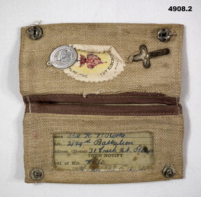 Bendigo Military Museum
Accessory - IDENTIFICATION, CATHOLIC, C.1940 - 45
H.V.Rooke. Refer Cat No 4906.2 for service details..1) Cloth folding wallet light brown colours, inside has small crucifix, badge and oval created edge piece sewn in, has central flower with black writing, other half has open piece with clear plastic sleeve for ID card. .2)Catholic Identification card black print 4 pages, front has space for owners details, written in blue ink..1) “Thy Kingdom Come”. .2) hand written, “VX47141 Pte H.V. Rooke 2/29th Battalion 31 creek St Bendigo, wife 31 Creek St Bendigo”accessory, id, identification, catholic -
 Federation University Historical Collection
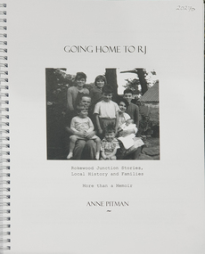
Book, Anne Pitman, Going Home to RJ: Rokewood Junction Stories, Local History and Families: More than a Memoir, 2023
Bev Chatham suggested tha tCommerlghip referes to Wtering holes and underground springs found in the Little Woady Yallok and Mt Misery Creeks. Rokewood Junction was proclaimed a township in 1885, originally known as a gold-mining township called Paddy's Gully Diggings.Ringbound publication of 212 pagesnon-fictionBev Chatham suggested tha tCommerlghip referes to Wtering holes and underground springs found in the Little Woady Yallok and Mt Misery Creeks. Rokewood Junction was proclaimed a township in 1885, originally known as a gold-mining township called Paddy's Gully Diggings. rokewood, rokewood junction, chatham, kurus-a-ruc, henry pitman, elizabeth pitman, william henry pitman, rokewood junction state school, commeralghip, paddy's gully bridge, illabrook, conereyalk, woady yalloak creek, mt misery creek, paddy's gully diggings., dereel, pitfield, wadawurrung, william rutland, squatters, aborigines, aboriginal, charlotte walsh, maurice walsh, julie pitman, ben liston, sheep and wool, george hawkins, natthew wakeling, christopher moody, mt misery goldfield, john bower, mary bower, hyslop's hotel, cumberland store, jane hyslop, edward collyer, jospeh gladstone, lucas's bakery, henry batty, william young, ellen rigby, chinese, joseph anguey, eliza anguey, murder of thomas ulick burke, william achultze, william schiltze, nicholas grenfell, tomas bramley murder, emily malhoff, drowning, ah lin, eliza richards, luisa bupell, eleanor holmes, rachel holmes, joseph holloway, noah holloway, thomas faulkner, robert eli hearn, george todhunter briggs, john robinson fairweather, rokewood common, edward bussell, louisa bussell, irving rachinger, john chatham, doris chatham, peter chatham, jack chatham, imogen chatham, domenico rizzoli, mary rizzoli, rokewood junction railway line, illabrook football and netball club, cape clear, red cross, keith annear, fire brigade, rokewood junction post office, len aarons, dereel pre-emptive right, rokewood junction avenue of honour -
 Federation University Historical Collection
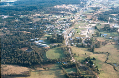
Photograph - Colour Photograph, Aerial View of Mt Clear, 1985, 1985
... clear mount clear TEchncial School canadian Creek Aerial View ...Aerial View of Mt Clear showing Mt Clear Technical School and Canadian Creek.mount clear, mount clear techncial school, canadian creek -
 Greensborough Historical Society
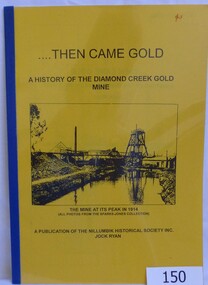
Book, Then came gold: a history of the Diamond Creek Gold Mine: by Jock Ryan, 2001_
The Diamond Creek Gold Mine was active from the 1860s and by 1912 had 12 known shafts. This book outlines ownership and contains anecdotes about the mine.A short history of the Diamond Creek Gold MineBook, 9 pages. Black and white illustrations and maps. Yellow front page with clear plastic cover.John Mackey in pencil inside front cover.diamond creek, john l ryan, jock ryan, diamond creek gold mine, gold discoveries victoria -
 Halls Gap & Grampians Historical Society
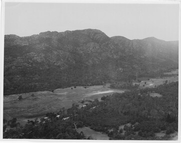
Photograph
Photo depicts Fyans Valley. The road is The Grampians/ Dunkeld Road, leading to Dunkeld towards the right or Halls Gap travelling towards the left. Fyans Creek is visible in parts at the foot of the range (middle of Photo). Photo appears to have been taken from Bellfield Pk area. Photo is typical of those taken by Forests Commission of Victoria in the 1960sPhoto shows a mountain range in the background with a valley. The Valley has a band of a mostly cleared grassy section (middle of photo) with a fairly dense treed area in the foreground. A road and some buildings can be seen where the cleared land meets the treed area.scenery, fyans valley -
 Eltham District Historical Society Inc
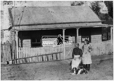
Negative - Photograph, Smart family home in Bridge Street, Eltham, c.1903
Believed to be Mrs Jane Bailey (nee Matthews) (d. 1904) and her grand-daughter Ruby Jane Bertha Smart (1890-1903) in front of the Smart family cottage in Bridge Street, Eltham, c.1903 Located on the north side of Bridge Street at the intersection with Bolton Street, facing Bolton Street (now part of present day Brisbane Street and occupied by the Kitchen Design Centre). Ruby Jane Bertha Smart born abt 1890 died in 1903 in Eltham. Her brother Alfred Francis Smart was born abt 1887 and died 1966 in Mont Albert, Vic. (Accessed via Ancestry.com) Show's an original early settler's cottage in Bridge Street. The cottage was built by Mrs Mary Jane Smart's parents, Edwin Bailey and Jane (nee Matthews). Mary Jane Smart was born in the cottage. She married an Englishman, Alexander Wilson Smart who disappeared to Western Australia in the early 1900s in search of gold. He ultimately married again in W.A., committing bigamy and then committed murder and was hung in 1911. This photo was taken c.1903 not long before both Mrs Bailey and her grand daughter both passed away. Jane Bailey died 2 Dec. 1904 and Mary Jane Smart and Ruby Jane Bertha Smart died July 1903 are all buried in Eltham Cemetery. SMART'S HOME AT ELTHAM. HIS WIFE AND SONS. In a little bush cottage surrounded by tall gum trees, through which appear glimpses of a willow fringed creek, of road ways hedged by masses of snowy flowering hawthorn, of growing crops and vividly green grazing paddocks, lives Mrs. Smart, the lawful wife of the man who is now in the hands of the police of Western Australia on suspicion of having committed a dreadful crime. Here, about half a mile out of the picturesque village of Eltham, she was born, and has lived her whole life — about 50 years. Smart himself lived here till the time when many years ago, the "lure of gold" got into his blood and he cleared out to Western Australia, to follow the digging rushes, gradually becom ing more and more estranged, till at length all communication ceased and be became lost to his wife and children. "I did not want him to go away," said Mrs. Smart, "because I had heard of so many men who had forgotten their homes in the excite ment of gold seeking, and of many others who died unknown and uncared for. But he would go, and when I saw his mind was set on it I placed no obstacles in his way. My parents built and lived in this cottage, where I was born, and they died in it. When I grew up I met my husband, a young Englishman, and married him. His name is Alexander, not Alfred, and his age is 52. We were very happy here, and although we were not well off we were comfortable, for he was a steady, sober, industrious man and had constant employment. He was just a manual worker, but could turn his hand to anything. We had five children, but one died. Four sons grew up in this little cottage. Thus three generations lived in it, somewhat unusual in an Australian bush home, I think. My eldest son is married and has a family; one is in Western Australia— not with his father— another is away working for him self, and one (indicating a young man by her side) has always stuck to his mother. He is my sole support, and he is as good to me now as his father once was. Yes, his father was a good, home-loving man in our younger days. He was fond of his children and was highly respected in these parts.' "It is fifteen years since my husband went away first. He had then been work ing for the Metropolitan Board of Works, and was engaged in the tunnel under the Yarra near Queen's-bridge when it col-lapsed. After he went to the West he sent me money regularly and wrote constantly. He came home three times — twice for a week or two at a time, the third time, eight years ago, when the Eitham railway was nearing completion. I induced him to stay till the railway opened, and he re-mained with me several months. I tried to get him to leave the West and settle down in his home, but he would not; he seemed restless and anxious to be off. One day when we were in Collingwood together he left me, saying he wanted to see what boats were going West. I implored him not to go away, and he said he would see. However, he returned to me soon after wards and said he had taken his ticket and would go by the next boat, and he went. For a year he wrote at irregular intervals, and then his letters ceased and I heard no more of him. For seven years I have not known whether he was alive or dead. Before that time my two sons in Western Australian used to see him some times, though they did not live with him; they used to tell me in their letters that he was well. It was a hard blow to be forgotten by him, but as my sons grew up I became more reconciled, and now I seem to look back at my life with him as some thing that happened a long time ago and is only a memory. Of his life and doings in Western Australia I know nothing. The last time I heard of him he was working in a foundry at Midland Junction. He was at Cue working on the railway when it opened there, and he caught the fever, but all that time he sent me money. When he returned the first time he took our eldest son with him, and the other boy followed later. They did not stay with him, how ever, and as far as I know they did not know how he lived." 'Mrs. Smart is a quiet, toil worn woman who has the respect of everyone who knows her.This photo forms part of a collection of photographs gathered by the Shire of Eltham for their centenary project book,"Pioneers and Painters: 100 years of the Shire of Eltham" by Alan Marshall (1971). The collection of over 500 images is held in partnership between Eltham District Historical Society and Yarra Plenty Regional Library (Eltham Library) and is now formally known as the 'The Shire of Eltham Pioneers Photograph Collection.' It is significant in being the first community sourced collection representing the places and people of the Shire's first one hundred years.Digital image 4 x 5 inch B&W Neg Original print 10.5 x 16.5 cmFor postcard print: Inscribed on envelope: "Return to Mrs H. Butherway, 22 Bridge St, Eltham." Also "Photo Mrs Clark Hampton (nee Smart), original Smart's house - Bridge Street, 95 years ago." Also "Right - Mrs Clark's grandmother Mrs J Smart Left - Her daughter Ruby dies soon after photo taken. Brother Alf Smart died about 6 years ago." Inscribed on back of photo "247 Vincent St, Leederville" It is believed that this inscription may be somewhat mixed up.sepp, shire of eltham pioneers photograph collection, eltham, bridge street, alexander wilson smart, bigamy, bush cottage, early settlers, houses, jane bailey (nee matthews), mary jane smart (nee bailey), murder, ruby jane bertha smart, smart family home, smart home -
 Eltham District Historical Society Inc
Photograph, Ruth H. Pendavingh, Duplication of Main Road bridge over Diamond Creek, Eltham
Originally contained in an A4 spiral bound blue plastic document folder with clear inserts of inkjet printouts, 3 images per page, 7 pages with explanatory notes and "Sue Law" at the top of each page.Low-resolution copy of colour photographmain road, road widening, bridge construction -
 Eltham District Historical Society Inc
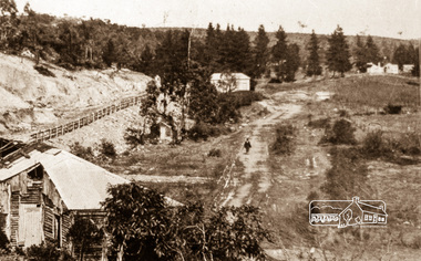
Negative - Photograph, Silvan Gully area, Upper Diamond Creek, c.1911
Silvan Gully area showing the cleared line for railway construction. The railway was extended from Eltham to Hurstbridge in 1912.Roll of 35mm colour negative film, 4 stripsKodak Safety 5035upper diamond creek, silvan gully, wattle glen, railway construction