Showing 79 items
matching construction of weir
-
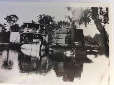 Port of Echuca
Photograph, Early 20th Century
... during the construction of the Yarrawonga weir in the 1930s which ...The P.S Australien was built in 1897 by Richard Wilson, of Moama. In 1937 the vessel was used to tow boilers, winches and derricks to the banks of the Murray River to aide in the construction of Locks 6,7,9 and Yarrawonga Weir. The barge is viewed from the rear, as the rudder can be seen, and shows the enormity of the loads of wool which a barge could carry. The two vessels are tied together and appear to be moored at a small pier.The P.S Australien is one of the oldest paddle steamers built at Echuca. It was a working vessel during the construction of the Yarrawonga weir in the 1930s which was the beginning of the irrigation system which enabled the Agriculture Industry to become such a prominent part of the Murray-Darling River Basin social history. A paddle steamer and a barge, loaded with wool, are seen docked together on a river. There is a small wooden jetty leading to the bank where gum trees are growing.p.s australien, yarrawonga weir, echuca paddlesteamers, murray river paddle steamers, wilson, richard, wool industry -
 Eltham District Historical Society Inc
Document - Folder, Survey Maps and Technical Drawings
alan gardiner collection, maps -
 Eltham District Historical Society Inc
Slide, Maroondah Aqueduct, Research, Victoria, 22 Mar. 1981
An inspection tour of the Maroondah Aqueduct was undertaken by the Shire of Eltham Historical Society on Sunday, March 22nd, 1981, commening where the aqueduct crosses Main Rd., Research, just below Eltham College. The Maroondah Aqueduct was part of Melbourne’s water supply system. It carried water over the 66 km from the Maroondah Reservoir on the Watts River at Healesville to the Preston Reservoir. Of this length, 41 km were open channel, 10 km, tunnel through hills and 15 km in 14 inverted siphons across stream valleys. The route of the aqueduct is north of Tarrawarra and Yarra Glen, along the Yarra escarpment south of Christmas Hills and crossing Watsons Creek into the present Shire of Eltham near Henley Rd. The eastern part of the route lies entirely within the former boundaries of the shire. The aqueduct passes south of Kangaroo Ground to Research and crosses the Diamond Creek by siphon at Allendale Rd., Eltham North. It then extends to Reservoir via St. Helena, Greensborough North and Bundoora. Water first flowed through the aqueduct in February 1891 when it was fed by a diversion weir on the Watts River. Records of the building of the aqueduct indicate that it was a significant construction achievement. The present Maroondah Reservoir was completed in 1927 and the aqueduct was enlarged at that time to take increased flows. About 1971 the section of the aqueduct through and north of Research was replaced by a large pipe and that section of the channel is now unused. The channel has remained largely intact (unlike sections at Greensborough and Bundoora where long lengths of the disused aqueduct have been demolished or filled in). The M.M.B.W. relinquished control of the disused aqueduct reserve which is crown land and the Shire of Eltham took control of this section of the reserve as a linear park. The Maroondah Aqueduct is considered to be an important historic structure, not just to the local area but to the metropolitan area generally. It is considered important to preserve substantially intact long lengths of the disused aqueduct, together with its bridges and other associated structures. 35 mm colour positive transparency (1 of 5) Mount - Agfachrome Agfa CS System black 8 dotsactivities, heritage excursion, maroondah aqueduct, research (vic.), shire of eltham historical society -
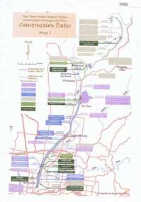 Greensborough Historical Society
Maps, Yan Yean Water Supply System Conservation Management Plan: Construction dates Map 1, 2007_
Plan of Yan Yean Water Supply System, showing natural and constructed features from 1850s to 1930s from Silver Creek Weirs to Eastern Freeway.Printed in colour one side. 3 copieswater supply, yan yean reservoir, plenty river -
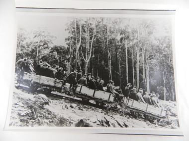 Kiewa Valley Historical Society
Photos - Box of 6, A3 size, Rubicon Scheme Construction
S.E.C.V. scheme prior to Kiewa Hydro Electric Scheme (and features in the SECV magazines.6 photos stored in yellow Kodak box. 1. Original Rubicon Falls Power Station Woodstave Pipeline Replaced since with steel pipe. B & W photo Est. 1940. 2. Original Wall of Eildon Weir was Submerged when new wall & new Power Station was built in Mid - Late 1950s. 3. B & W photograph of Rubion Falls Power Station under construction late 1920's - Early 1930's 4. Royston Woodstave Pipeline under construction parts of the pipeline are still in service Photo set. 1932 Timber used is Canadian Spruce 5.Rubicon Power Station in Foreground Construction buildings in background Rubicon Scene - late 1920's - early 1930's 6. Haulage Rubicon estimate mid-late 1920's. The means of transport to civilisation for the working parties constructing the Rubicon Scheme1.A.N. 427To R.J. Wegener Station Engineer. Rubicon Area 2. A.N. 429 3. A.N. 435 4. A.N. 436 5. A.N. 425 6. A.N. 437 rubicon scheme. woodstave pipe. rubicon pipeline. r.j. wegener. eildon weir. royston. canadian spruce. rubicon power station. rubicon haulage. state electricity commission of victoria. -
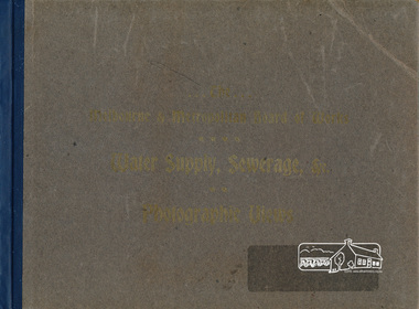 Eltham District Historical Society Inc
Book, The Melbourne & Metropolitan Board of Works Water Supply, Sewerage, etc. Photographic Views, 1908
In 1908 the Melbourne & Metropolitan board of Works published this book to illustrate its many constructions to provide Melbourne with its reticulated water and sewerage systems.This is now is a rare copy.Photographic images, landscape dimensions, hardboard cover, grey green colour Nilmmbw, weirs, dams & pumping stations, reservoirs, aqueducts -
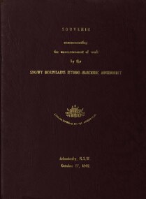 Federation University Historical Collection
book, Truth & Sportsman Ltd, Souvenir commemorating the commencement of work by the Snowy mountains hydro-electric authority, 17/10/1949
It is assumed that a member of the Ballarat School of Mines attended the commencement of work at the Snowy Mountains hydro-electric centre.Burgundy cover with gold printing. Black print, photos and diagrams on white paper (31 pages). Bound by 3 staples. The contents include the story of the Snowy. Images include W.J. McKell, J.B. (Ben) Chifley, J. McGirr, Nelson Lemmon, Hume Weir, Jindabyne valley (now flooded), Jindabyne township (now flooded), illustration of water Power, survey team at Adaminaby, Snowy Mountains Relief Plan, Horseman crossing the Eucumbene River, Mildura, Burrinjuck Dam under construction, transmission lines, W. Hudson.snowy mountains hydro-electricty scheme, snowy mountains hydro-electric authority -
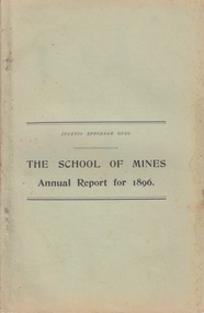 Federation University Historical Collection
Booklet - Annual Report and Calendar, Ballarat School of Mines Annual Report and Calendar, 1896
The Ballarat School of Mines was the first Technical School on Australia..1) Ballarat School of Mines Annual Report .2) Ballarat School of Mines calendar The Ballarat School of Mines Calendar and Annual Report 1896. Associateship of The School, Calendar for 1896, Certificates Granted by Education Department 1894, Certificates Issued by The School 1895, Certificates Issued Prior to 1895, Certificates Issued by Education Department 1895, Examiners, Examination Fees, Fees, Honorary Correspondents, Life Governors, Meteorological Observations, Number of Students attended The School, Office Bearers, Professors and Lecturers, Report of the Superintendent of Laboratories, Report of the Professor of Mineralogy, Geology and Botany, Report of the Professor of Engineering, Report of the Lecturer on Mathematics, Report of the Instructor in Engineering Drawing, Report of the Lecturer on Electricity, Report of the Teacher of Drawing, Report of the Lecturer in Veterinary Science, Statement of Receipts and Expenditure for year 1895, Statistics - Student attending Lectures, Subscriptions and Donations, Subjects Included in Regulations Technical Schools, Time Tableballarat school of mines, examiners, examination fees, fees, honorary correspondents, life governors, meteorological observations, number of students attended the school, office bearers, professors and lecturers, report of the superintendent of laboratories, report of the professor of mineralogy, geology and botany, report of the professor of engineering, report of the lecturer on mathematics, report of the instructor in engineering drawing, report of the lecturer on electricity, report of the teacher of drawing, report of the lecturer in veterinary science, statement of receipts and expenditure for year 1895, statistics - student attending lectures, subscriptions and donations, subjects included in regulations technical schools, time table, annual report, calendar, andrew anderson j.p. - president, hon. r. t. vale - vice president, r. denham pinnock - vice president, the hon. sir w. j. clarke - trustee, the hon. john warrington rogers - trustee, the right reverend samuel thornton - trustee, andrew anderson - trustee, james millhinch - trustee, james oddie - trustee, the hon. henry cuthbert - honorary solicitor, r. g. middleton - honorary treasurer, charles kent - auditor, fred. j. martell - director and registrar, professor alf. mica smith - chemistry, metallurgy, natural philosophy, professor purdie - geology, mineralogy, principles of mining, professor g. j. dawbarn - mine and land surveying, mining mechanics, hydraulics, civil engineering, applied mechanics, j. rowe - practical mining, w. huey steele - electrical technology, electricity and magnetism, d. walker - chemistry and natural philosophy, w. e. bennett - mathematics, henry j. hall - freehand and perspective drawing, a. e. c. kerr - mechanical drawing (machine construction and design), j. f. usher - paleontology, zoology, materia medica, professor purdie - botany, george clegg - building construction, l. hart - photography, h. g. a. brown - carpentry, r. e. weir - veterinary science, daniel walker, henry cuthbert, james millhinch, jams oddie, j.f. usher -
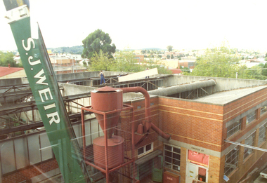 Federation University Historical Collection
Photograph - Colour, Ballarat School of Mines Building Site
.1) Ballarat School of Mines Building Site showing the Flecknoe Building (right) with the M.B. John Building under construction (left).ballarat school of mines, m.b. john building, flecknoe building, flecknoe, s.j. weir, albert street -
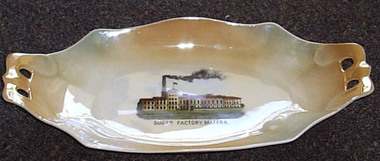 Maffra Sugarbeet Museum
Souvenir Plate
... , and led to the construction of the Glenmaggie Weir ...A tangible reminder of how important the sugar beet factory and the sugar beet industry was to Maffra, is the production of souvenir-ware with images of the factory. The Sugar Beet industry was highly significant in the Maffra area for just under 50 years, and led to the construction of the Glenmaggie Weir and the consequent Macalister Irrigation District. The item lacks detailed provenance, but is obviously local.Oblong cream and tan souvenir plate with photograph of "Sugar Factory, Maffra" printed in centre. The ends are extended to form handles, each pierced with two holes.Sugar Factory Maffra [crown] / Victoria / China / Czechoslovakiasugarbeet -
 Maffra Sugarbeet Museum
Book, Cattle Feeding with Sugar Beets, Sugar, Molasses and Sugar Beet Residuum
... for just under 50 years, and led to the construction ...Frank Pywell was manager of the Maffra Sugar Beet FactoryThe Sugar Beet industry was highly significant in the Maffra area for just under 50 years, and led to the construction of the Glenmaggie Weir and the consequent Macalister Irrigation District. This book is one of a number from the private library of the factory manager, and the entire collection of them provides a unique insight into information available at the time of manufacture. It is unlikely a collection of this breadth on sugarbeet is held anywhere else in Australia.Hardcover book "Cattle Feeding with Sugar Beets, Sugar, Molasses and Sugar Beet Residuum", 1902, 390 pages illus."F.J.Pywell" inside front cover "R.J. Shingles" page preceding title page. Stamp "Technical Library / Department of Agriculture / Melbourne" in several placessugarbeet -
 Bendigo Historical Society Inc.
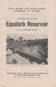
Document - EPPALOCK RESERVOIR ON THE CAMPASPE, STATE RIVERS AND WATER SUPPLY 1960
Booklet, 23 pages, detailing the construction of the Eppalock Reservoir. Printed on front cover 'State Rivers and Water Supply Commission of Victoria. Construction of the Eppalock Reservoir on the Campaspe River'. Photograph on front cover shows the Campaspe River at Eppalock. Water flowing over the existing weir. Information contained in the booklet pertains to the history of weirs along the Campaspe and the development of the Eppalock project. Black and white photos of opening ceremony of build and historical photos of weirs.bendigo, waterworks, eppalock weir -
 Puffing Billy Railway
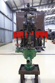
Steam Driven Weir Pump, 1900s
G. and J. Weir of Holm Foundry, Cathcart, Glasgow and now known as the Weir Group. The company was established in 1871 as an engineering firm by two brothers, George and James Weir, founding G. & J. Weir Ltd. The Weir brothers produced numerous groundbreaking inventions in pumping equipment, primarily for the Clyde shipyards and the steam ships built there. These pumps became extremely well known for their use as boiler feedwater pumps, and for ship's auxiliary equipment such as evaporators. Under W D Weir, the company turned to producing munitions and war material in the First World War. As well as shells, they manufactured aircraft including the Royal Aircraft Factory F.E.2 fighter and bomber. James George Weir (aviator, son of James Galloway Weir) a director of the company formed the Cierva Autogiro Company. G & J Weir would be a financial supporter of the company during its existence. In 1943, they provided the finances for the construction of the W.9, an experimental helicopter, to Air Ministry requirements. It was first listed on the London Stock Exchange in 1946. Double-acting Weir steam pumps were virtually standard fitment on British-built steamships, being used for pumping water, fuel, air and much else well into the 1950s, as well as being used on other ships worldwide. Historic - Double-acting Weir steam pumpSteam Driven Pump made of iron & steel puffing billy, weir pump, weir, steam driven pump -
 Tatura Irrigation & Wartime Camps Museum
Photograph, Goulburn Waranga Main Channel Construction, 1957
Photo taken by the photographer for Victoria State Rivers and Water Supply Commission of the Goulburn Waranga main channel in 1957.Large black and white photograph - dry mounted to cream board. Channel excavation scene with excavator, bucket upraised, in right foreground. Two men looking at something, left foreground. Two small figures mid distance.Below photo: "Goulburn Waranga Main Channel Construction / Bucyrus 200 W. Excavator with 6 c. yd. Bucket / Looking towards off-take at Goulburn Weir / Completed Excavation in Background.goulburn, waranga, irrigation, photo, victoria state rivers and water supply commission -
Tatura Irrigation & Wartime Camps Museum
Photograph, Goulburn Waranga Main Channel Construction, 1957
Photo taken by the photographer for Victoria State Rivers and Water Supply Commission of the Goulburn Waranga main channel in 1957.Large black and white photograph - dry mounted to cream board. Channel excavation scene - with excavator bucket in operation, right foreground. Two men, one arm raised, pointing, in left foregroundBelow photo: "Goulburn Waranga Main Channel Construction / Bucyrus 200 W. Excavator with 6 c. yd. Bucket / Looking towards off-take at Goulburn Weir / Completed Excavation in Background.goulburn, waranga, irrigation, photo, victoria state rivers and water supply commission -
Tatura Irrigation & Wartime Camps Museum
Photograph, Goulburn Waranga Main Channel Construction, 1957
Photo taken by the photographer for Victoria State Rivers and Water Supply Commission of the Goulburn Waranga main channel in 1957.Large black and white photograph - dry mounted to cream board. Channel excavation scene - with excavator bucket in operation / Man operation machine right foreground / Several small indistinct figures mid distance working in channel bed.Below photo: "Goulburn Waranga Main Channel Construction / Bucyrus 200 W. Excavator with 6 c. yd. Bucket / Looking towards off-take at Goulburn Weir / Completed Excavation in Background.goulburn, waranga, irrigation, photo, victoria state rivers and water supply commission -
Tatura Irrigation & Wartime Camps Museum
Photograph, Goulburn Waranga Main Channel Construction, 1957
Photo taken by the photographer for Victoria State Rivers and Water Supply Commission of the Goulburn Waranga main channel in 1957.Large black and white photograph - dry mounted to cream board. Channel excavation scene - with excavator operating right mid distance, scoop bucket operating top of earth wall left mid distance, supervised by figure on top of earth wall.Below photo: "Goulburn Waranga Main Channel Construction / Bucyrus 200 W. Excavator with 6 c. yd. Bucket / Looking towards off-take at Goulburn Weir / Completed Excavation in Background."goulburn, waranga, irrigation, photo, victoria state rivers and water supply commission -
Tatura Irrigation & Wartime Camps Museum
Photograph, 1936
Photo taken by the photographer for Victoria State Rivers and Water Supply CommissionMedium sized black and white photograph. Eildon Reservoir overall picture - Original reservoir and dam / rock and earth fill dam wall and construction huts left of centre / trees foreground / tree covered hills top left and across top / dam water / with leisure craft near wall.goulburn, irrigation, photo, victoria state rivers and water supply commission, eildon, eildon weir -
Tatura Irrigation & Wartime Camps Museum
Photograph, Goulburn Weir, 1890
... of weir under construction Two carpenter's trestles foreground.... View from south of weir under construction Two carpenter's ...Taken by photographer for State Rivers and Water Supply Commission.Medium sized black and white photograph. View from south of weir under construction Two carpenter's trestles foreground Trees in mid distance background Canoe in middle dry channel in foregroundvictoria state rivers and water supply commission, goulburn weir -
Tatura Irrigation & Wartime Camps Museum
Photograph, May, 1888
Taken by photographer for State Rivers and Water Supply Commission.Medium sized black and white photograph. Weir wall of granite blocks nearing completion viewed from downstream. Construction camp of tents and sheds mid-picture beyond wall.goulburn weir, victorian state rivers and supply commission -
Tatura Irrigation & Wartime Camps Museum
Photograph, 13/04/1918
Taken by photographer for State Rivers and Water Supply Commission.Medium sized black and white photograph. Eildon Reservoir overall picture / dam wall and construction huts left of middle / dam filled with water right of wall / tree covered hills beyond.goulburn weir, victorian state rivers and supply commission -
Tatura Irrigation & Wartime Camps Museum
Photograph, Goulburn Waranga Main Channel Construction, 1957
Photo taken by the photographer for Victoria State Rivers and Water Supply Commission of the Goulburn Waranga main channel in 1957.Large black and white photograph - dry mounted to cream board. Channel excavation scene with excavator in right foreground, bucket scooping earth in middle foreground, two small figures of men working mid-distance.Below photo: "Goulburn Waranga Main Channel Construction / Bucyrus 200 W. Excavator with 6 c. yd. Bucket / Looking towards off-take at Goulburn Weir / Completed Excavation in Background.goulburn, waranga, irrigation, photo, victoria state rivers and water supply commission -
 Rutherglen Historical Society
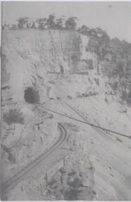
Image, c1928
... -country Photocopies of Hume Weir photographs 1928-29 hume weir ...Photocopies of Hume Weir photographs 1928-29One of three black and white photographs, photocopied onto a single sheet of A4 paper. This one is of construction work on a cliff face, with train lines, tunnel and cable.Written on paper next to photo: "Detail of open cut for [illeg.]. Train lines for taking rock to crusher tunnel & stay ropes of suspension bridge showing"hume weir, suspension bridge, bridges, tunnels, construction -
 Rutherglen Historical Society
Image, October 1929
... -country Photocopies of Hume Weir photographs 1928-29 hume weir ...Photocopies of Hume Weir photographs 1928-29One of two black and white photographs, photocopied onto a single sheet of A4 paper. This one is of construction work on a dam, with scaffolding above a partially completed wall. Water is flowing through several valves in the wall.Written on paper next to photo: "Valves etc. at Hume Weir Oct '29"hume weir, construction, dam construction -
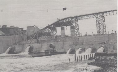
 Rutherglen Historical Society
Image, October 1929
... -country Photocopies of Hume Weir photographs 1928-29 hume weir ...Photocopies of Hume Weir photographs 1928-29One of two black and white photographs, photocopied onto a single sheet of A4 paper. This one is of construction work on a dam, showing lower part of dam wall, and featuring one of the valves.Written on paper next to photo: "Needle valve Hume Weir Albury Oct '29"hume weir, construction, dam construction -
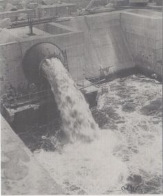
 Rutherglen Historical Society
Image, c 1930
... Black and white photograph of the Hume Weir under... construction On back of photo: "Hume Weir" and an oval rubber stamp "V ...Black and white photograph of the Hume Weir under construction.On back of photo: "Hume Weir" and an oval rubber stamp "V. Peterson | Photographer | Hume Reservoir"hume dam, hume weir, hume reservoir, lake hume, dam construction -
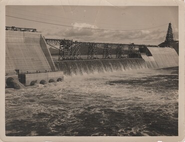
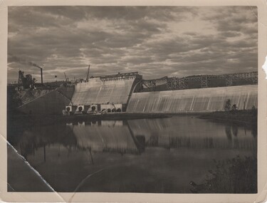 Rutherglen Historical Society
Image, c 1930
... Black and white photograph of the Hume Weir under... construction On back of photo: "Hume Weir" and an oval rubber stamp "V ...Black and white photograph of the Hume Weir under construction.On back of photo: "Hume Weir" and an oval rubber stamp "V. Peterson | Photographer | Hume Reservoir"hume dam, hume weir, hume reservoir, lake hume, dam construction