Showing 44 items matching "diamond creek mine"
-
 Eltham District Historical Society Inc
Book, Diamond Creek Basin Study. Part 1, A Compendium of Factors Relevant to Stormwater Flows, 1980
Basin Studies are studies to evaluate water supply and demand and help ensure reliable water supplies by identifying strategies to address imbalances in water supply and demand.Spiral Bound. 157 leaves in various foliations (some folded) : illustrated. (some colour.), maps (some colour.)aerial photographs, allendale road, arthurs creek mine, arthurs creek road bridge, arthurs creek, bald spur look-out, bank protection, bolton steet, bridge street bridge, bridge street, bridges, challenger street, chute street, construction, coolaroo drive, culvert, deep creek, diamond creek basin, diamond creek region, diamond creek, diamond street bridge, drainage works, eltham lower park, eltham town park, eltham trestle bridge, eltham west drains, eltham, erosion, flood management, floods, footbridge, glen katherine estate, gold mining, gum glade, hurstbridge, kangaroo ground, kinglake escarpment, kinglake national park, latiners hat factory, main road bridge, main road, masons falls, melbourne metropolitan board of works, monash bridge, mount sugarloaf, nillumbik park, orchards, railway culvert, railway line, ramptons road, real estate advertisement, research creek, st helena east drain, st helena road, st helena, storm sewers, stormwater, sugarloaf-preston transfer main crossing, susan street, union mine, village pond, water flow, watkins street, wattletree road, weidlich road, wingrove park, yarra river, zig zag road, water supply, basin study -
 Eltham District Historical Society Inc
Folder, Victorian Goldfields Project: Historic gold mining sites in St Andrews mining division, 1999
Heritage site report and gazetteer by David Bannear, head consultant for archealogy for the Department of Natural Resources and Environment. Includes information on the Warrandyte Goldfield and the Caledonia Goldfield, Queenstown (now known as St Andrews), One Tree Hill, Kingston (now known as Panton Hill), Kangaroo Grounds, You You Hill, Kingstown, South Morang, Nillumbik, (now known as Diamond Creek), Steele's Creek, Yarrambet and Kinglake. Photocopy of map headed: Location of mines and reefs from Geological survey of Victoria, Yan Yean with the Diamond Creek prominant on the map. no date35 page report with map and print out of cover letter (email form) from donorcaledonian gold fields, caledonina gold field, david bannear, gold mining, harry gilham collection, queenstown, st andrews, warrandyte goldfield -
 Eltham District Historical Society Inc
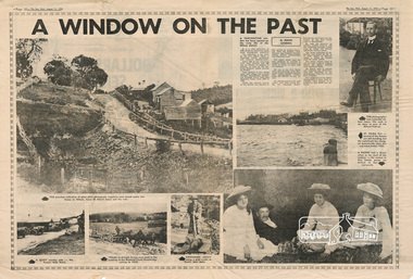
Newspaper - Newsclipping, Roger Sanders, A WINDOW ON THE PAST, 11 Aug 1976
Published in "The Sun", Wednesday, August 11, 1976, pp 38-39 [Text of article:] A WINDOW ON THE PAST by Roger Sanders. A fascinating window has been opened on the early life of the Eltham district. It is a rare collection of 3,000 perfectly preserved glass plate photograph negatives. The collection is the work of the late Albert Jones, a Diamond Creek orchardist and amateur photographer. About 500 of the negatives have been printed and 100 are on display at Gallery 4, Eltham, as part of the Eltham Festival, which started on Friday. They capture in fine detail rural and village life around Eltham, Hurstbridge, Kangaroo Ground, Yarra Glen and Diamond Valley from 1900 to 1930. While the natural beauty of the district was painted in this period by Arthur Streeton (later Sir Arthur), Tom Roberts and Charles Conder, among others, photography was relatively new. Yet Albert Jones used the new medium to compile a weighty album of pioneers at work, at home, at sport and on holidays. He was at the first Yarra Glen race meeting, early Diamond Valley football matches and photographed soldiers from the district leaving for war. He photographed early gold mines, men with horses laying the Diamond Creek-Hurstbridge rail track and the arrival of the first steam train at Hurstbridge. He took his cameras on holiday around Victoria and the collection includes scenes from St. Kilda and Portsea and many country towns. The Jones collection of negatives was found by Mr A. J. "Ned" Spark, of Balwyn, under a house he bought from Mr Jones' widow. The plates almost went to the tip with a pile of rubbish before Mr Spark realised their potential value. Mr Spark, who is retired, will continue the identification and recording of the photographs when he returns from holidays. The exhibition of the Jones' photographs is open each afternoon until August 21 at Gallery 4, 1016 Main Rd., Eltham. [Captions of photographs included in article:] • The priceless collection of glass plate negatives were found under this house in Eltham [actually Wattle Glen], home of Albert Jones and his wife. • A quiet country pub - Panton Hills Hotel. • Teams of draught horses were used in the building of the Diamond Creek-Hurstbridge railway in 1910. • Chinaman Jimmy using a gold cradle in Wattle Glen Gully. • The photographer and orchardist Albert Jones. His work is on show as part of the Eltham Festival • St Kilda Pier – several of the houses are still standing, but the waterfront has changed dramatically since this was taken before 1920. • A picnic was a dressy affair at the start of the century – the women in this family group are decked in lace and pearls.Newspaper articlealbert jones, golden glen, wattle glen -
 Greensborough Historical Society
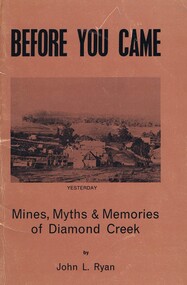
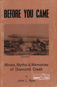
Book, Before you came: mines, myths and memories of Diamond Creek. By John L Ryan, 1972
A history of Diamond Creek from earliest records of white visitors (1836) to the 1970s. John Ryan was born in Diamond Creek and lived there all of his life.A detailed history and anecdotes of the Diamond Creek area and its early pioneers.55 pages. Soft cover, light brown with copy of early painting of Diamond Creek on front cover. Black and white illus. 3 copiesOn page one in pencil: John Mackeydiamond creek, john l ryan -
 Greensborough Historical Society
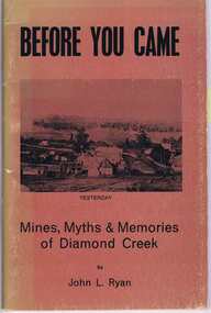
Book, New Life Publications, Before you came: mines, myths and memories of Diamond Creek. By John L Ryan, 1972c
A history of Diamond Creek from earliest records of white visitors (1836) to the 1970s. John Ryan was born in Diamond Creek and lived there all of his life.A detailed history and anecdotes of the Diamond Creek area and its early pioneers.55 pages. Soft cover, light brown with copy of early painting of Diamond Creek on front cover. Black and white illus. -
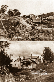 Eltham District Historical Society Inc
Negative - Photograph, Albert Jones, 'Golden Glen' at Wattle Glen and the Wattle Glen General Store, c.1910
Top photo: The property 'Golden Glen', home of photographer, Albert Jones. At the right of the photo is an apple orchard over the other side of Watery Gully creek. The middle building in the photo is still standing, located on Wattle Glen - Kangaroo Ground Road between Pretty Hill Lane and Millers Road (Melway 271 A6) but on the opposite side of the road. Bottom photo: The Wattle Glen General Store in this photo was located at the same intersection as the present Wattle Glen General Store (cnr of Reynolds Road and Kangaroo Ground Road) but on the diagonally opposite corner. [Comment from Valda via Victorian Collections June 11, 2018] "The addition to the store on the left, and the building at the back, were not part of the store/post office owned by the Keenan's. They were added by Mr and Mrs Alan (Janet) Frencham's in the ?mid-1950s." See also EDHS_03112: See Ref: EDHS_03112 A WINDOW ON THE PAST by Roger Sanders, The Sun, Wednesday, Auguist 11, 1976, pp 38-39 A fascinating window has been opened on the early life of the Eltham district. It is a rare collection of 3,000 perfectly preserved glass plate photograph negatives. The collection is the work of the late Albert Jones, a Diamond Creek orchardist and amateur photographer. About 500 of the negatives have been printed and 100 are on display at Gallery 4, Eltham, as part of the Eltham Festival," which started on Friday. They capture in fine detail rural and village life around Eltham, Hurstbridge, Kangaroo Ground, Yarra Glen and Diamond Valley from 1900 to 1930. While the natural beauty of the district was painted in this period by Arthur Streeton (later Sir Arthur), Tom Roberts and Charles Conder, among others, photography was relatively new. Yet Albert Jones used the new medium to compile a weighty album of pioneers at work, at home, at sport and on holidays. He was at the first Yarra Glen race meeting, early Diamond Valley football matches and photographed soldiers from the district leaving for war. He photographed early gold mines, men with horses laying the Diamond Creek-Hurstbridge rail track and the arrival of the first steam train at Hurstbridge. He took his cameras on holiday around Victoria and the collection includes scenes from St. Kilda and Portsea and many country towns. The Jones collection of negatives was found by Mr A. J. "Ned" Spark, of Balwyn, under a house he bought from Mr Jones' widow. The plates almost went to the tip with a pile of rubbish before Mr Spark realised their potential value. Mr Spark, who is retired, will continue the identification and recording of the photographs when he returns from holidays. The exhibition of the Jones' photographs is open each afternoon until August 21 at Gallery 4, 1016 Main Rd., Eltham. Photographs included in article: • The priceless collection of glass plate negatives were found under this house in Eltham [actually Wattle Glen], home of Albert Jones and his wife. • A quiet country pub - Panton Hills Hotel. • Teams of draught horses were used in the building of the Diamond Creek-Hursbridge railway in 1910. • Chinaman Jimmy using a gold cradle in Wattle Glen Gully. • The photographer and orchardist Albert Jones. His work is on show as part of the Eltham Festival • St Kilda Pier – several of the houses are still standing, but the waterfront has changed dramatically since this was taken before 1920. • A picnic was a dressy affair at the start of the century – the women in this family group are decked in lace and pearls.Roll of 35mm colour negative film, 4 stripsKodak Safety 5035albert jones, golden glen, shops, wattle glen -
 Eltham District Historical Society Inc
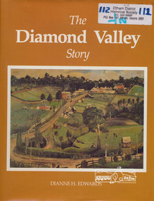
Book, Dianne H. Edwards, The Diamond Valley Story / Dianne H. Edwards, 1994
Review in Heidelberg Historian (Newsletter of Heidelberg Historical Society) No 80 October 1980 "This substantial and significant history is one of the really essential books which all members interested in the history of Heidelberg and district should have, for, as indicated in this work, the Diamond Valley and Heidelberg were linked together in a municipal, economic and geographical sense throughout their history and still have strong links. This work of 191 pages, with numerous illustrations, covers the entire period of the history of the Shire area, from Greensborough to Hurstbridge (to 1979). Starting with a geographical setting, Miss Edwards traces the early development of the historic district from Hume & Hovell to the first explorers and settlers with some discussion on the meeting of John Batman with the aborigines here. Details of the early residents follow with numerous portraits, including the Beales of St Helena and the Ryries of Yering. In part 2, the account continues of the later settlers and squatters like Henry Foley and C. S. Haley. The gold discoveries on the Plenty and at the Diamond Creek and Queenstown area then follow with the development of the townships of Hurstbridge and Diamond Creek, with details of the mines and miners of the last century until its decline in the 1870's." "During the writing of the book, 40 tapes were made by the authoress Dianne Edwards of local residents reminiscences".. Diamond Valley News February 6, 1979This book was published by the former Shire of Diamond Valley in 1979. It remains one of the key local history titles particularly for the Diamond Creek and Greensborough areas.Paperback; xiv, 194 p. : ill., ports. ; 29 cm.ISBN 0959542205diamond valley, greensborough, hurstbridge, john batman, st helena, henry foley, queenstown, diamond creek, gold mining -
 Eltham District Historical Society Inc
Book, John L. Ryan, Before you came : mines, myths & memories of Diamond Creek / by John L. Ryan, 1972
... melbourne Subtitled mines, myths and memories of Diamond Creek ...Subtitled mines, myths and memories of Diamond Creek the book covers the following topics: early days, first settlers, Nillumbik- the town, state school, the churches, growth of a town, early pioneers and stories of the past. PhotographsPaperback; 55 p. : ill., port. ; 21 cm.ISBN 0959895019diamond creek, nillumbik, gold mining, gold miners -
 Federation University Historical Collection
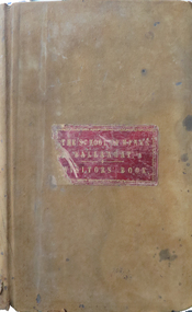
Book, Ballarat School of Mines Visitors' Book, 1879-1890, 1879-1890
James Redmond Gilbert (sr) was born in 1837 at Hamilton, Ontario, Canada. He married Ellen Spouse. He , James Gilbert died on 26 July 1900 at Melbourne, and is buried at Boroondara Cemetery (Kew). J.R Gilbert lived at Running Creek (later Havilah) for some time, and during that time was employed in one of the bigger mines in the district. (Research by Ren at Havilah Research, 2019) Leatherbound ledger with hand written names, professions, residence and remarks relating to visitors to the Ballarat School of Mines. Sample Names: 1881 May 2 David Kerr Diamond Miner South Africa May 2 S. R. Dodds Diamond Miner South Africa May 3 Albert E. King Accountant Adelaide, South Australia "see signature 6 leaves back" May 6 William Morley Wesleyan Minister Auckland, New Zealand May 6 Rainsford Ravin Wellington, New Zealand May 7 Frank E. Lawrence, Lake River, Tasmania May 9 M. Richter Engineer Germany May 9 Dr Wilhelm Landall naturalist Berlin, Germany May 10 William Ralph Heaton Mercantile Birmingham May 11 Arthur I. Traill Grazier Llanpollen, New South Wales May 10 Marian Traill 1882 July 10 Arthur W.W. Brown London July 10 Benjamin Spargo Mining Mananger and owner Snowy Creek July 10 Thomas Cooke Miner Ballarat July 14 Robert H. Kenny July 14 Mr and Mrs Buston, [Indigo Planter?] Bengal, Indonesia July 14 Samuel H. Halker Ballarat July 14 Charles Phelan Talbot July 14 E. Walker Ballarat 1884 June 30 M.N. Cooper Dunedin, new Zealand June 30 Richard Hosking gardiner Gong Gong Well pleased with School June 30 Humphrey John Ballarat July 1 Cecily Gilbert Melbourne July 1 Florence Shrivall Melbourne July 1 [W.N. Marsh?] Colonial Secretary Hong Kong July 1 Louis Fause Engine Driver Dunolly July 1 John L. Bertram Blacksmith Melbourne July 1 Thomas Eardley Coachmaker London "Exceedingly obliged to Mr Oddie for a very pleasant instruction time spent in inspection of the various scientific appliances in the Ballarat School of Mines." (Donation 2/6) July 4 E. Goodwin [David?] Artist Spellbound July 4 W. Glumley Station Master Murtoa July July 4 James Thomas Miner Corrinondie, New Zealand "Very pleased with the School in all its branches. I hope to contribute to the specimen department. J.T." July 8 Robert Wall Engine Driver 1885 September 16 J.W. Springthorpe, M.D., Melbourne (very much pleased in every way) September 26 M. Oddie, Ballarat 1886 January 12 William Piekard, Leicester, England January 12 Robert Linford, Norwich, England January 12 H. Tipping, Draughtsman, Adelaide (Very instructive and should be taken advantage of by all who can) January 12 Fred H.K. Dreslecher, London (ditto) January 23 Walter Redgate, Manchester (ditto) April 7 Annie Bellingham, Richmond April 9 Fred Kruger, Landscape Photo, Geelong April 14 Mary Barry, Murtoa April 19 N.J. Tabuteau Accountant Napier, New Zealand April 19 George N. [Baroft?] Gentleman Cheshire, England April 21 Hon. George D'Almaine, Peer of England, London April 21 Lord Augustus Honour April 21 William Holt, South Melbourne April 21 H. Bartell, Gentleman, Smythes April 21 Fred Musgrove, Gentleman April 21 A. Chirnside, Squatter April 23 Alice Cravino, student, Buninyong April 24 East Melbourne Bicycle Club April 28 J. Kinnear, Kyneton April 28 J.P. Kinnear, Kyneton May 19 Bob Selby, Doctor, Ballarat May 19 J.W.M.. Quiggin, globe trotter, Picton (NS Wales) May 25 Arthur Night, Sutton Hotel, Ballarat (very fair) May 28 D. Kelly, attendant, China May 28 J. Kelly, schoolboy, China June 1 Joseph Jelbart, Blacksmith, Harrow September 9 David Ham, M.L.C. Ballarat ( A right to be pleased) September 9 J.J. Green, Merchant, Adelaide (Very much pleased with my visit to this intitiution it has my hearty sympathy and appreciation, Much pleased at what I have seen its value to the community) 9 December James H. Tappin, Agent, Ballarat (very pleased with instruction 1887 March 20 Thomas Bath Learmonth March 20 James R. Gilbert= Miner Running Creek March 20 C. Holtermann Out of business Adelaide 1890 21 May Mr and Mrs Fairchild, gentleman. Yarra house, Dalgety St, St Kildaballarat school of mines, visitors, j.w. springthorpe, chinese visitors, visitors' book, running creek, james redmond gilbert sr, havilah -
 Bendigo Historical Society Inc.
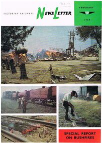
Document - BADHAM COLLECTION: NEWSLETTER FEBRUARY1969 SPECIAL REPORT ON BUSHFIRES
Victorian Railways Newsletter February 1969 Special report on bushfires. Glossy paper with colour photos on front of bushfires in relation to railway property. The contents include photos of effects of the fire to VR property, closure of State coal mines, photos of fire destroyed bridge at Diamond Creek, Molesworth, the Powlett River Coal Field in 1910 (Wonthaggi), and Kirrak Mine. Printed at the Victorian railways printing works Laurens St North Melbourne.magazine, government, victorian railways, victorian railways newsletter / photos of effects of the fire to vr property/ closure of state coal mines / photos of fire destroyed bridge at diamond creek / molesworth/ the powlett river coal field in 1910 ( wonthaggi) / kirrak mine / printed at the victorian railways printing works laurens st north melbourne -
 Bendigo Historical Society Inc.
Document - ''THE CHINESE ON THE BENDIGO GOLDFIELD'': PAPER BY ''JOCH'' ( J. O. O'HATTAM)
''The Chinese on the Bendigo Goldfield'' - draft paper with pencilled and typed annotations by ''Joch'' (J O O'Hattam) - undated. ; last page states ''Extracts from letters in the O'Breen family, and personal research; These letters were written between 1856 and 1899 by Shane O'Breen''. Mention of - two distinct 'groups' of Chinese (Canton & via California) with their stated differences in appearance and type of working; differences between European and Chinese mines (shafts as well as drives i.e. circular as against rectangular; 'smoking' of the shafts and tunnels by the Chinese; space in Chinese camps i.e. crowding; condition of Chinese camps; fire at Emu Creek camp of 1887; names of camps - Golden Square, Jackass Flat, Myers Flat, Kangaroo Flat, White Hills, Kennington, East Bendigo (Grassy Flat) and ''as far out as Diamond Hill''; Constable Ryan disappearance.Shane O'Breenbendigo, chinese, history, goldfields, chinese. o'breen family, shane o'breen, constable ryan. pigtail. cantonese. chinese smoked shafts and tunnels. emu point. opium smoking shop. joss house. golden square. jackass flat, myers flat, kangaroo flat. white hills, kennington. west bendigo (grassy flat). diamond hill. -
 Bendigo Historical Society Inc.
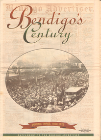
Newspaper - LONG GULLY HISTORY GROUP COLLECTION: BENDIGO'S CENTURY VOLUME THREE: 1920 - 1929
Newspaper supplement titled Bendigo's Century Volume Three: 1920 - 1929. Front page has a photo of The Duke and Duchess of York visit to Bendigo, 1927. Each year has heading of Who's Who, Weather, Sport and Business. First years are 1910 - 1919 titled The way we were. 1920 is titled Prince hailed. 1921 - City racks up a milestone. 1922 - Furore erupts. 1923 - Felons escape from city gaol. 1924 - Bid to finish RSL memorial. 1925 - Foul odour over sewerage plan. 1926 - Lest we forget Bendigo's fallen. 1927 - Royal Visit captures city. 1928 - Four shot in farm tragedy. 1929 - Billie's trip to remember.bendigo, history, long gully history group, the long gully history group - bendigo's century - volume three: 1920 - 1929, bendigo advertiser, duke and duchess of york, cr e m vains, r putnam, a j taylor, j h jackson, w crowley, sandhurst football club, george lansell, st peter's church, bendigo junior technical school, prince of wales, unity mine, mr w wilson, badak tin mining syndicate, mr t w ortonmr h scarborough, mr raleigh, general sir w r birdwood, the soldiers' memorial committee, bendigo city council, rsl memorial hall, captain g c wilson, lietenant r j parer, lieutenant j c mcintosh, cr j p carolin, h k morris, e a morris, turf tavern hotel, rev donald baker, all saints' pro--cathedral, keck's nursery, bendigo amalgamated goldfields, rising sun hotel, leanne mcdonnell, most rev john mccarthy, sir john quick, prime minister billy hughes, state rivers and water supply commission, diptheria, edna stevens, bendigo railway workshops, watson sustenance fund, sir joseph cook, dr lanza, bendigo amalgamated goldfields, bendigo benevolent asylum, miner's phthisis, bendigo gas company, electric light company, bendigo sewerage authority, commonwealth bank, cr curnow, the earl of stradbroke, dame nellie melba, princess theatre, lt-col g hurry, h sw lawson, countess of stradbroke, clunes woollen mills, girton college, mrs polglaise, mrs kennedy, gold discovery memorial, cr m g giudice, victorian co-operative freezing company, bendigo brick and tile company, mr lawson, soldiers' memorial, windermere hotel, toni riley pharmacy, bendigo gaol, mr a a dunstan mla, new red white and blue mine, claude de vere, walter osborne, sir john and lady quick, jonathan smalley, bendigo advertiser, st paul's bells, mr t cambridge, epsom public hall, bendigo school of mines, major lansell, mr h s w lawson, cr david andrew, colonel hurry, mr s bruce, bendigo sewerage authority, eppalock weir scheme, bendigo football league, r s l memorial, major g v lansell, lempriere, mr s m bruce, sandhurst hotel, market square, big hill tunnel, bendigo football league, bendigo united cricket club, south bendigo rex, sacred heart cathedral, hercules mine, gillies, aids & appliance shop, anne caudle centre, fizelle & mulqueen, south new moon mine, bendigo sewerage authority, mr a a kelley, epsom sewerage works, white hills botanical gardens, mr j sternberg mlc, bendigo book of remembrance, bendigo football league, senator general drake-brockman, captain dyett, school of mines, handschin and romus, hanro (aust.) bendigo knitting mills, charles handschin, farmers' union, andrew sunstan mla, country progressive party, john allan, captain g j c dyett, eahlehawk ufs dispensary, data fundamentals, the duke and duchess of york, the hercules mine, cr j a michelsen, lansell family, bendigo agricultural society, huntly shire council, bendigo creek trust, south african war memorial, cr j h curnow, st paul's church of england diamond jubilee, bendigo chamber of commerce, bendigo freezing works, bendigo pottery, bendigo trotting club, new red white and blue mine, the conservatory, cr e g batchelder, hercules mine, billie rigby, bendigo railway station, travellers' aid society, eppalock weir, the state rivers and water supply commission, bendigo railway workshops, frank grove, cr curnow, electric supply company, state electricity commission, australian aero club, bendigo preserving company, jardine, busbridge, feeman, mr h pearce, bfl, fred wood -
 Greensborough Historical Society
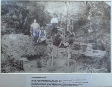
Photograph - Photograph (Framed), Early miners at work, 1850s
... . John Davidson diamond creek gold miners mines and mining ...Early miners at work caption reads: "The large bucket, called kibble, is used to pull up the unwanted debris, the smaller iron buckets are used to raise the alluvial material containing gold. This material is mixed with water in the puddling barrells (foreground) and poured into the cradle (left). The rocking motion causes the gold specks to sink to the bottom from where it is collected. The remaining material may then be hand washed in the gold pan held by the miner." This photograph possibly taken at Diamond Creek.From the John Davidson collection.Photograph in black plastic frame with typed caption on matte.john davidson, diamond creek, gold miners, mines and mining -
 Eltham District Historical Society Inc
Photograph - Digital Photograph, Marguerite Marshall, One Tree Hill Mine, Smiths Gully, 8 June 2006
Gold was discovered on One Tree Hill in 1854. The site has been worked intermittently until fairly recent times. Published: Nillumbik Now and Then / Marguerite Marshall 2008; photographs Alan King with Marguerite Marshall.; p53 Though still a working mine, One Tree Hill Mine at Smiths Gully, now stands in a tranquil reserve surrounded by bush and native animals - in contrast to its heyday. In the mid 19th century, when the mine was part of the Caledonia Goldfields, hundreds of men in search of their fortune worked the alluvial gold in the Yarra River, its tributaries and the reefs that made up the goldfields. Miner Stan Bone, assisted by Wilfred Haywood, is the last of the independent gold miners in the area and still uses the quartz crushing battery as miners did when gold was first discovered in the area in 1851.1 Stan, who is the last of six generations of miners in his family, was aged 17 when he began mining on his father Alex’ mine, The Golden Crown in Yarrambat. These days, after blasting the gold-bearing rock in Mystery Reef, one of the four reefs at One Tree Hill, Stan transports it around five kilometres by tip truck to the Black Cameron Mine for crushing. There he uses water from the waterlogged mine, (which still contains gold), as the Happy Valley Creek at One Tree Hill is usually dry.2 The One Tree Hill Mine has been worked for close to a century since it opened around the late 1850s.3 The Swedish Reef was its most productive reef and one of the largest in the area. Around 1859, extractions included 204 ounces (5.8kg) of gold, won from 57 pounds (26kg) of stone.4 Then during World War Two, Stan’s uncle, Bill Wallace, and Alex Bone, closed the mine. In 1973, Stan, with his Uncle Bill, reopened the Black Cameron Mine and worked there until 1988. Stan resumed mining One Tree Hill in 1998. As late as the 1920s gold was picked up by chance! When crossing a gully on his way to vote at the St Andrews Primary School, Bill Joyce picked up some quartz containing gold. This site was to become the Black Cameron Mine. The Caledonia Diggings, named after Scotland’s ancient name by local Scots, began around Market Square (now Smiths Gully) and included Queenstown (St Andrews), Kingstown (Panton Hill) and Diamond Creek. There were also poorer bearing fields in Kangaroo Ground and Swipers Gully (now Research). * None of these compared in riches to the Ballarat and Bendigo fields5, but the Caledonia Diggings continued intermittently for close to 100 years. Gold was discovered in Victoria following a bid to stem the disappearance of much needed workmen to the New South Wales diggings. Several businessmen offered a reward of £200, for the discovery of gold within 200 miles (322 km) of Melbourne. Late in June 1851, gold was first discovered at Andersons Creek, Warrandyte. Then in 1854, George Boston and two other men discovered gold at Smiths Gully. Gold transformed the quiet districts, with a constant flow of families and vehicles on the dirt tracks en route to the Caledonia Diggings. Three thousand people worked the gullies in Market Square, including about 1000 Chinese miners. The square established its own police, mining warden, gold battery, school, shops and cemetery and grog flowed. Market Square flourished until the middle 1860s. Bullocks transported quartz from the Caledonia Goldfields to the crushing machinery at the Queenstown/St Andrews Battery, near Smiths Gully Cemetery. It was destroyed by bushfire in 1962. By the late 1850s, most early alluvial fields were in decline, but minor rushes continued until around 1900 and some until the early 1940s. Some miners did well, although most earned little from their hard labour in the harsh and primitive conditions.6 But according to historian, Mick Woiwod, the gold fields helped to democratise society, as individuals from all walks of life were forced to share experiences, and the ability to succeed, depended less on inherited wealth or social rank.This collection of almost 130 photos about places and people within the Shire of Nillumbik, an urban and rural municipality in Melbourne's north, contributes to an understanding of the history of the Shire. Published in 2008 immediately prior to the Black Saturday bushfires of February 7, 2009, it documents sites that were impacted, and in some cases destroyed by the fires. It includes photographs taken especially for the publication, creating a unique time capsule representing the Shire in the early 21st century. It remains the most recent comprehenesive publication devoted to the Shire's history connecting local residents to the past. nillumbik now and then (marshall-king) collection, gold mining, one tree hill mine, smiths gully