Showing 424 items matching "farm buildings"
-
 University of Melbourne, Burnley Campus Archives
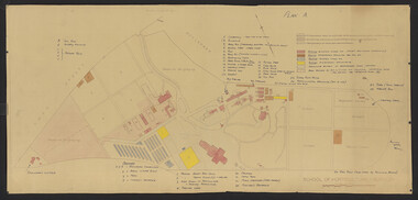
Plan - Coloured plan, Thomas H. Kneen, School of Horticulture - Burnley, 1948-1949
... farm buildings... gardens burnley school of horticulture farm buildings Amended 24 ...Colour-coded to show existing and proposed buildings, numbered and lettered to indicate use of buildings Related documents: B91.476, B91.484Plan with handwritten amendments by T.H. Kneen on 24.10.1949. Extensive explanation of existing and proposed structures at the College. Plan A: area bounded by Swan St., Yarra Boulevard, reserves for grazing, orchard and vegetable gardens along southern boundary. Amended 24/10/49 T.H. Kneent.h. kneen, burnley gardens, burnley school of horticulture, farm buildings -
 Eltham District Historical Society Inc
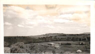
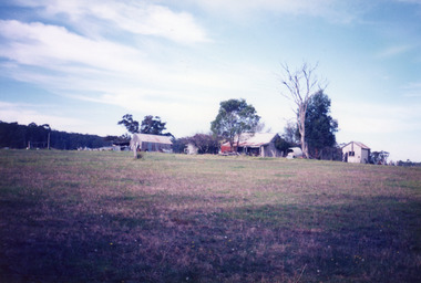
Photograph - Digital Photograph, Marguerite Marshall, Stuchbery Farm dairy, 14 March 2008
... farm buildings... Stuchbery dairy Stuchbery Farm farm buildings Yarrambat Plenty Gorge ...Stuchbery Farm was situated on the Plenty River bounded by Smugglers Gully to the north and La trobe Road, Yarrambat, to the east. Alan and Ada Stutchbery moved to the valley in 1890, first living in a tent where four children were born. Alfred built a home and outbuildings around 1896. They planted an orchard, then a market garden and developed a dairy. Published: Nillumbik Now and Then / Marguerite Marshall 2008; photographs Alan King with Marguerite Marshall.; p179 The dramatic steep-sided Plenty Gorge lies along the divide of two geological areas, and separates the Nillumbik Shire and the City of Whittlesea. On the Nillumbik side are undulating hills and sedimentary rock, and in Whittlesea, lies a basalt plain formed by volcanic action up to two million years ago. This provides the Plenty Gorge Park with diverse vegetation and habitats, making it one of Greater Melbourne’s most important refuges for threatened and significant species. The park, established in 1986, consists of around 1350 hectares, and extends 11 kilometres along the Plenty River, from Greensborough to Mernda. It provides a wildlife corridor for around 500 native plant and 280 animal species. The area’s plentiful food and water attracted the Wurundjeri Aboriginal people and then European settlers. By 1837 squatters had claimed large runs of land for their sheep and cattle. The Plenty Valley was among the first in the Port Phillip District to be settled - mainly in the less heavily timbered west - and was proclaimed a settled district in 1841. But by the late 1880s, the settlers’ extensive land clearing for animal grazing, then agriculture, depleted the Wurundjeri’s traditional food sources, which helped to drive them away. Many Wurundjeri artefacts remain (now government protected), and so far 57 sites have been identified in the park, including scarred trees, burial areas and stone artefacts. Pioneer life could be very hard because of isolation, flooding, bushfires and bushrangers. Following the Black Thursday bushfires of 1851, basalt was quarried to build more fire-resistant homes. Gold discoveries in the early 1850s swelled the population, particularly around Smugglers Gully; but food production made more of an impact. In the late 1850s wheat production supplanted grazing. In the 1860s the government made small holdings available to poorer settlers. These had the greatest effect on the district, particularly in Doreen and Yarrambat, where orchards were established from the 1880s to 1914. Links with a prominent early family are the remains of Stuchbery Farm, by the river’s edge bounded by Smugglers Gully to the north and La Trobe Road, Yarrambat, to the east. The Stuchberys moved to the valley in 1890, and the family still lives in the area. In 1890, Alfred and Ada first lived in a tent where four children were born, then Alfred built the house and outbuildings around 1896. They planted an orchard, then a market garden, and developed a dairy. The family belonged to the local Methodist and tennis communities. Their grandson Walter, opened the Flying Scotsman Model Railway Museum in Yarrambat, which his widow, Vi, continues to run. Wal was also the Yarrambat CFA Captain for 22 years until 1987. Walter sold 24 hectares in 1976 for development - now Vista Court - and in 1990, the remaining 22.6 hectares for the park. Remaining are an early stone dairy and remnants of a stone barn, a pig sty and a well. Until it was destroyed by fire in 2003, a slab hut stood on the Happy Hollow Farm site, at the southern end of the park. The hut is thought to have been built in the Depression around 1893. This was a rare and late example of a slab hut with a domestic orchard close to Melbourne. Emmet Watmough and his family first occupied the hut, followed by a succession of families, until the Bell family bought it around 1948. There they led a subsistence lifestyle for 50 years, despite encroaching Melbourne suburbia. The Yellow Gum Recreation Area includes the Blue Lake, coloured turquoise at certain times of the year. Following the 1957 bushfires, this area was quarried by Reid Quarries Pty Ltd for Melbourne’s first skyscrapers, then by Boral Australia. However in the early 1970s water began seeping into the quarry forming the Blue Lake and the quarry was closed. The State Government bought the site in 1997 and opened it as a park in 1999.This collection of almost 130 photos about places and people within the Shire of Nillumbik, an urban and rural municipality in Melbourne's north, contributes to an understanding of the history of the Shire. Published in 2008 immediately prior to the Black Saturday bushfires of February 7, 2009, it documents sites that were impacted, and in some cases destroyed by the fires. It includes photographs taken especially for the publication, creating a unique time capsule representing the Shire in the early 21st century. It remains the most recent comprehenesive publication devoted to the Shire's history connecting local residents to the past. nillumbik now and then (marshall-king) collection, ada stuchbery, alan stuchbery, dairy, stuchbery farm, farm buildings, yarrambat, plenty gorge park -
 Hume City Civic Collection
Photograph
... A black and white photograph of a farm buildings... collection A black and white photograph of a farm buildings ...A black and white photograph of a farm buildings at Rupertswood with Jackson Creek in the near background and the Caloola Training Centre on the hill in the background.sunbury asylum, rupertswood, farming, clarke, william (sir), farmbuildings, salesian order, caloola training centre, george evans collection -
 Lakes Entrance Historical Society
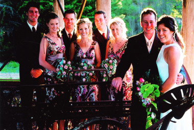
Photograph - Wedding/Whelan, 8/04/2007 12:00:00 AM
... and Lisa Whelan taken at farm building Nyerimilang Park Nungurner... at marriage of Chris and Lisa Whelan taken at farm building ...Colour photograph of the wedding party at marriage of Chris and Lisa Whelan taken at farm building Nyerimilang Park Nungurner Victoriacelebrations -
 Tatura Irrigation & Wartime Camps Museum
Model - Farm building, 1940
... Model - Farm building...Model of a farm building, roof painted dark red, interior... of a farm scen by children tatura toys general Model of a farm ...Made by internee camp 3 tatura used as part of a farm scen by childrenModel of a farm building, roof painted dark red, interior green, both decorated , trees, overall backgroun, walls flesh colour.tatura, toys, general -
 Sunbury Family History and Heritage Society Inc.
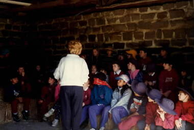
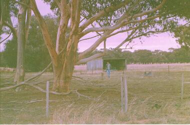
Photograph, School Excursion, cEarly 1990s
... sitting on hay bales in a dingy farm building with bluestone walls... of children sitting on hay bales in a dingy farm building ...The students from Bulla Primary School were taken to one of the farms in the local area to introduce them farm life.A non-digital coloured photograph of a group of children sitting on hay bales in a dingy farm building with bluestone walls. A lady is supervising the children.school excursions, bulla primary schooil, farms -
 Bendigo Historical Society Inc.
Photograph - NORM GILLIES COLLECTION: PHOTOGRAPH TRACTOR SHED, NARREWILLOCK
... inspecting the resite of the farm buildings photo details the Tractor... the resite of the farm buildings photo details the Tractor shed ...Coloured photograph Site of Gillies Farm, one man inspecting the resite of the farm buildings photo details the Tractor shed on site Dec. 1999 -
 Lakes Entrance Historical Society
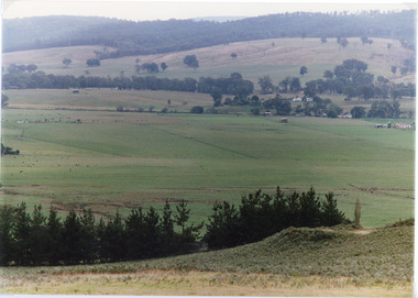
Photograph - Sarsfield Flats, Tambo Shire, 1994 c
... of cattle grazing and farm buildings, foothills in background... and farm buildings, foothills in background, and glimpse ...Also second identical copyColour photograph of Sarsfield Flats. Distant view of cattle grazing and farm buildings, foothills in background, and glimpse of mountains. Pine trees in the foreground. Bruthen Victoriaagriculture, topography -
 Lakes Entrance Historical Society
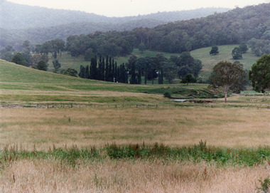
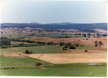
Photograph - Timbarra, Tambo Shire, 1994 c
... , showing well grassed paddocks in foreground farm buildings... paddocks in foreground farm buildings in valley wooded foothills ...Colour photograph of grazing country in the Timbarra region, showing well grassed paddocks in foreground farm buildings in valley wooded foothills in background. Timbarra Victoriaagriculture, primary industry, animals -
 Sunbury Family History and Heritage Society Inc.
Photograph
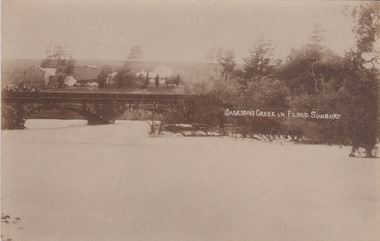
... with the water almost reaching the two arches on the stone bridge. Farm... bridge. Farm buildings can be seen in the middle distance ...The post card is a record of a time when the Jacksons Creek flooded and the water almost reached the two arches on the Macedon Street Bridge. The Goonawarra Winery buildings can be seen in the back ground.A sepia photograph in post card format of a river in flood with the water almost reaching the two arches on the stone bridge. Farm buildings can be seen in the middle distance.JACKSON'S CREEK IN FLOOD SUNBURYmacedon street bridge, jacksons creek, goonawarra winery -
 Lakes Entrance Historical Society
Photograph - Historic House, Bennett, Vera, 1991
... , showing a timber and corrugated iron structure amongst farm... structure amongst farm buildings and trees. Lakes Entrance Victoria ...Date made May 1991|Old building demolished c2008. Ostler family arrived at Cunninghame (Lakes Entrance) by boat, walked to the site with their belongings, cleared the land, built a dwelling, farmed dairy herd, grew maize, had beehives.| Also one colour photograph of new dwelling constructed next to the old dwelling taken 29th September 2007|Also two other colour photographs old dwelling.Colour photograph of Ostlers old home, 106 Ostlers Road, showing a timber and corrugated iron structure amongst farm buildings and trees. Lakes Entrance Victoriahouses, local history -
 Lakes Entrance Historical Society
Photograph - Gillingal Station, Tambo Shire, 1994 c
... Colour photograph of Gillingal Station, showing the farm... Colour photograph of Gillingal Station, showing the farm ...Also second identical copyColour photograph of Gillingal Station, showing the farm buildings situated on a hillside and surrounded by rising hill country and fertile valleys, cattle grazing in home paddock. Buchan Victoriaagriculture, primary industry -
 Bendigo Historical Society Inc.
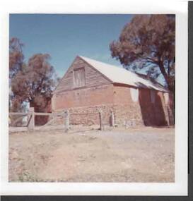
Photograph - FARM BUILDING
... FARM BUILDING...Photo: coloured photo off farm (?) building. Building...: coloured photo off farm (?) building. Building has stone base ...Photo: coloured photo off farm (?) building. Building has stone base, brick walls and timber and iron roof. In front of photo, post and rail fence with iron gate.buildings, farming, stone building, architecture, heritage -
 Orbost & District Historical Society
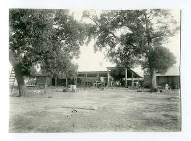
black and white photograph, early 20th century
... Watt- farm agriculture-buildings... farming families in the district. Watt- farm agriculture-buildings ...Mr John Watt set up farming in 1879. He was a native of Port Fairy. He was educated in Scotland and came back to Victoria and selected 320 acres on the Snowy River.The property extended from Majors Creek Road to around about Gilbert's Gulch.The Watt family settled in Orbost as farmers being one of the first farming families in the district.A black / white photograph showing wooden farm sheds and wagons. a small wooden house is on the right hand side and there are tall trees in the fioreground.on back - Mrs Watts farmwatt- farm agriculture-buildings -
Phillip Island and District Historical Society Inc.
Book, BAIRD, Patricia, Churchill Island heritage farm : visitors guide, 2005
... -island-and-the-bass-coast churchill island heritage farm historic ...churchill island heritage farm, historic buildings, victoria, history, churchill island -
 Lakes Entrance Historical Society
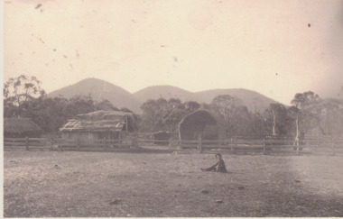
Photograph - Settlement, 1890
... Sepia toned photograph of bark roofed farm building and hay... roofed farm building and hay stack behind three railed post ...Sepia toned photograph of bark roofed farm building and hay stack behind three railed post and rail fence, sliprail gateway. Boy and dog seated in foreground. High peaks in distance known as The Brothers. East Gippsland Victoriahouses, topography, settlers -
 Lakes Entrance Historical Society
Photograph - Mossiface Flats, Tambo Shire, 1994
... for grass hay. Farm buildings in foreground and background. Dam... for grass hay. Farm buildings in foreground and background. Dam ...Also second identical copyColour photograph of the Mossiface Flats, near Bruthen, shows paddocks of the rich river flats, timbered foothills in the distance, with mountain range behind. Some paddocks have been mown for grass hay. Farm buildings in foreground and background. Dam in foreground. Bruthen Victoriaanimals, agriculture, vegetation, topography -
 Federation University Historical Collection
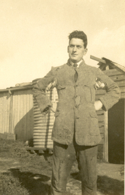
Photograph - Photograph - Black and White, Vernon Holt, Frank Wright at Smeaton (possibly at Sewell's), 1/8/1922
... hands on his hips. In the background are farm buildings..., standing with his hands on his hips. In the background are farm ...Frank Wright was a renown resident of Smeaton, where he was born. He lived at Laura Villa, and attended Smeaton State School. His father William was a gold miner and his mother's name was Sarah. Their family won many singing and instrumental awards. Frank was tutored by Percy Code and was awarded a gold medal for the highest marks in the ALCM examinations in the British Colonies at the age of seventeen years. He became the Australian Open Cornet Champion by the age of eighteen. A year later, Frank conducted the City of Ballarat Band, and later the Ballarat Soldiers’ Memorial Band. He formed the Frank Wright Frisco Band and Frank Wright and his Coliseum Orchestra. These bands won many South Street awards, and Frank as conductor won many awards in the Australian Band Championship contest. In 1933 Frank Wright sailed to England to conduct the famous St Hilda’s Band and was later appointed Musical Director of the London County Council, where he organized many amazing concerts in parks, in and around the London district. He was made Professor of Brass and Military Band Scoring and conducted at the Guildhall of Music and Drama. Frank was often invited to adjudicate Brass Band Championships around Europe, in Australia, including South Street and in New Zealand. The Frank Wright Medal at the Royal South Street competition is awarded to an individual recognized as making an outstanding contribution to brass music in AustraliaTwo different sized identical black and white photographs of a man dressed in ragged jacket and trousers, standing with his hands on his hips. In the background are farm buildings and a water tank.The man is Frank Wright and the place is Smeaton. .1) postcard sized photograph .2) small photograph.1) Printed on back - Post Card, Kodak, Australia .2) Written in pen on back - Frank Wright, Smeaton, 1/8/22, Photo by Vernon Holtfrank wright, ballarat, cornet, conductor, smeaton, vernon holt -
 Linton and District Historical Society Inc
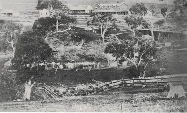
Photograph, Early Pitfield, Showing Bridge, Store and Hotel
... shows trees, fencing and farm buildings in foreground... shows trees, fencing and farm buildings in foreground ...Identified by inscription on the back of the photograph as "Early Pitfield", and the buildings as "Matthew Hamilton Baird's . . . hotel & store". Information from Joan Hunt (see 'Pitfield/Kaleno' file) says the Emu Inn or Pitfield Hotel was at Pitfield/Wardy Yallock township on the road from Skipton to Geelong. Part of this area - foreground, to the left, was called "Buncle's Flat", named after John Buncle, a carpenter who lived in a cottage there with his family. An early timber inn on the Wardy Yallock Creek was owned first by Peter Hardie and then by Edward Langhorne/John McNamara in the 1840s and a mail run from Geelong was established to it in 1846. Matthew Hamilton Baird was the lessee or owner from 1852, and Benjamin Fernald from about 1860. In 1853, the nearby store, at that time owned by William Whitecross, caught fire. The fire spread to the hotel and both buildings were destroyed. The hotel was replaced by the brick or stone building seen in the photograph.Small black and white copy of original photograph which shows trees, fencing and farm buildings in foreground, and in the background a large stone or brick building plus smaller timber buildings (dwellings?) situated along a roadway. On the right of the photograph the road goes over a large bridge of timber construction.On back of photograph: "Early Pitfield showing Matthew Hamilton Baird's store (stone?) & hotel & store".pitfield bridge, pitfield hotel, pitfield township, buncle's flat, emu inn, buildings, hotels, matthew hamilton baird, benjamin fernald, edward langhorne, john mcnamara, william whitecross -
 Bendigo Historical Society Inc.
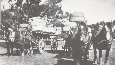
Photograph - HARRY BIGGS COLLECTION: WOOL CARTING
... ) Trees are visible in the background and possibly some farm... some farm buildings. Photograph HARRY BIGGS COLLECTION: WOOL ...Photograph (proof 69) of two teams of Clydesdales hitched to wagons that are loaded with bales of wool. The wagon on the left of the photo has two horses, and the team on the right has team of four. Only one of the drivers is visible ( on the left hand team) Trees are visible in the background and possibly some farm buildings.topic, farming, wool carting, working horses, clydesdales, carting wool, farming -
 Lakes Entrance Historical Society
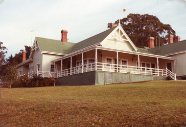
Photograph - Nyerimilang, Fish Marie, 1982
... Also two other photographs of derelict farm buildings...Also two other photographs of derelict farm buildings ...Also two other photographs of derelict farm buildings at Nyerimilang Park, Kalimna West, Victoria.Colour photograph of homestead taken at Nyerimilang Park soon after purchase by Victorian State Government. Kalimna West Victoriahouses, local history -
 Warrnambool and District Historical Society Inc.
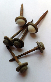
Functional object - Household nails, Early 20th century
... to hang pictures or as studs for farm buildings etc. ... or as studs for farm buildings etc. Limited significance but typical ...These nails have no provenance but may have been used to hang pictures or as studs for farm buildings etc. Limited significance but typical of nails previously in regular use.These are 13 large iron nails. Two of them are shorter than the others and have a top with a brass edging and a white oval shaped inset of porcelain or enamel material. Eleven of them have an iron top. ‘Coop’s Latest’nails, warrnambool history -
 Buninyong & District Historical Society
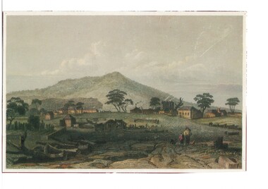
Artwork, other - Colour reproduction of lithograph "Township of Buninyong" c1852, "Township of Buninyong" c1852
... clearing, cultivation, residential and farm buildings and Mount... clearing, cultivation, residential and farm buildings and Mount ...Early image of Buninyong c1852 showing evidence of land clearing, cultivation, residential and farm buildings and Mount Buninyong with tree coverBuninyong was one of the earliest settlements Victoria and became a very important place in the history of the goldrushColour reproduction of lithograph "Township of Buninyong" c1852 from the cover of "Three Times Blest"Henry Winkles Township of Buninyong c 1852 Lithograph, originally published in Montgomery Martin's "Australia" Reproduced "Three Times Blest"early settlement, henry winkles, mount buninyong, buninyong -
 Bendigo Historical Society Inc.
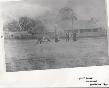
Photograph - HARRY BIGGS COLLECTION: ELLMSWOOD, Circa 1890
... A copy of a photograph of a farmhouse with farm building... of a photograph of a farmhouse with farm building in the background ...A copy of a photograph of a farmhouse with farm building in the background. Surrounding the house is a picket fence, in the foreground are three adults and five children. One of the women is holding a child and the other is holding a child by the hand. There is a man with a beard and wearing a Bowler hat standing between the two women. There are three other children; two boys on tricycles, and a girl standing between them. Written at the base of the photo is First Home, Ellmswood, Serpentine 1890topic, farming, farm house, serpentine , ellmswood -
 Greensborough Historical Society
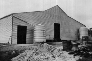
Photograph - Digital image, John McLaughlin's Plenty, 1932_
... . This photograph shows a farm building at Plenty.... the Greensborough and Eltham areas. This photograph shows a farm building ...Part of a collection of photographs owned by Dorris McLaughlin who was born in Greensborough, in 1899 to John McLaughlin and Rosalie Ellen Whatmough. The collection contains photographs of friends and relatives from the Greensborough and Eltham areas. This photograph shows a farm building at Plenty.Digital copy of black and white photograph.dorris mclaughlin, john mclaughlin, plenty -
 Greensborough Historical Society
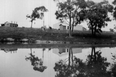
Photograph - Digital image, John McLaughlin's Plenty, 1933, 1933_
... . This photograph shows farm buildings at Plenty reflected in water.... the Greensborough and Eltham areas. This photograph shows farm buildings ...Part of a collection of photographs owned by Dorris McLaughlin who was born in Greensborough, in 1899 to John McLaughlin and Rosalie Ellen Whatmough. The collection contains photographs of friends and relatives from the Greensborough and Eltham areas. This photograph shows farm buildings at Plenty reflected in water.Digital copy of black and white photograph.dorris mclaughlin, john mclaughlin, plenty -
 Kiewa Valley Historical Society
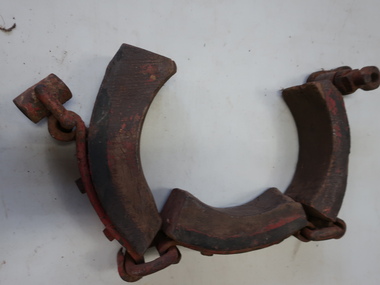
Dray Brake Band, Horse Equipment
... Drays were used to transport heavy materials such as farm... used to transport heavy materials such as farm products ...Drays were used to transport heavy materials such as farm products, building supplies, food. They were pulled by horses or bullocks. Drays were important for transportation in the Kiewa Valley.Made of timber and steel. The piece of wood contacts the axle hub to brake the dray. Part of a brake for a dray. It is missing the actuator that is needed for tightening the band to operate as a brake.drays, horses, bullocks -
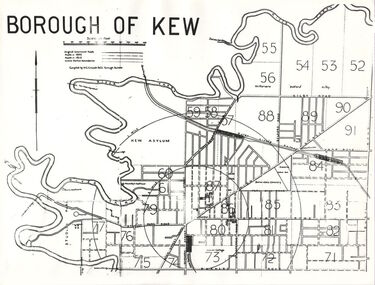 Kew Historical Society Inc
Plan, Borough of Kew, 1910
... of the plan are marked with the location of particular buildings... of the plan are marked with the location of particular buildings ...This work forms part of the collection assembled by the historian Dorothy Rogers, that was donated to the Kew Historical Society by her son John Rogers in 2015. The manuscripts, photographs, maps, and documents were sourced by her from both family and local collections or produced as references for her print publications. Many were directly used by Rogers in writing ‘Lovely Old Homes of Kew’ (1961) and 'A History of Kew' (1973), or the numerous articles on local history that she produced for suburban newspapers. Most of the photographs in the collection include detailed annotations in her hand. The overhead transparency is of a map produced by H.C. Crouch Borough Surveyor in 1910The Rogers Collection provides a comprehensive insight into the working habits of a historian in the 1960s and 1970s. Together it forms the largest privately-donated collection within the archives of the Kew Historical Society.An overhead transparency of a plan of Kew comparing the roads in 1860 with later roads constructed by 1910. Sections of the plan are marked with the location of particular buildings, farms or transport routes.Borough of Kewborough of kew, h.c. crouch -
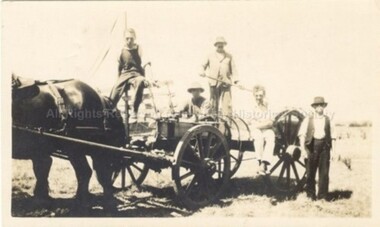 Malmsbury Historical Society
Photograph (Item), Dodd Family With Farm Machinery C1920, Malmsbury c1920
... People - Dodd Family Buildings - Farm Machinery...-ranges People - Dodd Family Buildings - Farm Machinery Dodd ...People - Dodd Family Buildings - Farm Machinery -
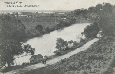 Lakes Entrance Historical Society
Postcard - Eagle Point bluff, silt Jetties and Jones' Bay, Eagle Point Victoria, A W Burman Bairnsdale, 1912 c
... and Jones' Bay small farm and buildings, hop kiln on bank opposite... Jetties and Jones' Bay small farm and buildings, hop kiln on bank ...Letter on back dated Dec 30 1912 to Mrs Brewer Signed FloraBlack and white postcard showing view of Mitchell River looking east towards Eagle Point bluff and the silt Jetties and Jones' Bay small farm and buildings, hop kiln on bank opposite bluff and hop paddock. Horse and jinker on gravel road Eagle Point VictoriaMitchell River Eagle Point Bairnsdale waterways, rivers, jetties, roads and streets, transport