Showing 40 items matching "forest measurement"
-
 Department of Energy, Environment and Climate Action
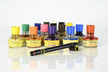
Coloured mapping inks and pens
... Forest measurement...) mapping Forest measurement Surveying Pelikan Pelikan coloured inks ...Coloured ink used to mark lines of paper maps. Could be used in pen or as a "wash" to colour areas with a soft sable hair paint brush Strict cartographic guidance was provided by the FCV’s 1947 publication - “Handbook of Conventional Signs and Symbols for Use in Forest Mapping and Plan Drawing”. It was slow and exacting work but very rewarding.Pelikan coloured inks in small glass bottlesPelikan forests commission victoria (fcv), mapping, forest measurement, surveying -
 Forests Commission Retired Personnel Association (FCRPA)
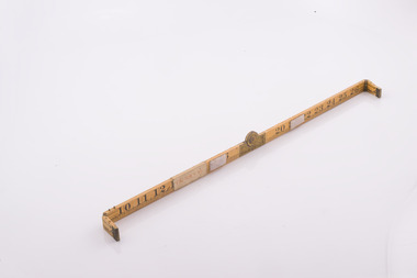
Basal Area Angle Gauge
... Forest measurement... area. It’s very quick and effective. Forest measurement Forests ...Foresters usually measure the diameter of trees at Breast Height – traditionally 4 foot, 6 inches – now 1.3 m – which is termed Diameter Breast Height Over Bark (DBHOB). Basal Area is the cross section of the tree trunk at breast height, and the sum for the stand or group of trees is expressed square feet per acre (after 1973 it was expressed in square metres per hectare). Lots of skinny trees, or a few fat ones, can have the same Basal Area, but when combined with the number of stems, Basal Area is a good indicator of stand density. Two common methods are used to measure of Basal Area – fixed area plots and angle count sampling. 1. Fixed area plots require setting out a small area, commonly 50 m x 20 m, and measuring all the trees at breast height, and doing some quick sums. 2. Angle count sampling involves a simple sweep of the forest from a fixed sampling point using a relascope, dendrometer sight, angle gauge, or glass wedge prism. This wooden builders ruler has been shaped at one end to create a shallow angle (usually less than 3 degrees). Standing in one spot, a sweep is made with the wedge held to the eye, and trees are counted as either “in” or “out”. The number of trees is multiplied by conversion factor of the wedge (10 in this case) to estimate basal area. It’s very quick and effective.Basal Area Angle Gauge The two ends fold up and one end (on the right) has been reduced in width to create a shallow angle for the viewer Home made by cutting down a wooden builder's ruler Many forestry students made their own Basal Area Angle Gauges and its thought this may be oneforest measurement, forests commission victoria (fcv) -
 Forests Commission Retired Personnel Association (FCRPA)
Gunter's Chain
... Forest measurement... superseded by steel ribbon tape. Forest measurement Surveying Forests ...Before metrication was introduced into Australia in the 1970s land was measured in chains and links. Many old parish plans show length measurements in chains and links. Area was shown in acres, roods and perches. Gunter's chain was used for measuring distance in surveying. It was designed and introduced in 1620 by English clergyman and mathematician Edmund Gunter (1581–1626). Gunter developed the measuring chain of 100 links. The chain and the link, became statutory measures in England and subsequently the British Empire. After metrication units of length were measured in meters and area in hectares. The chain was later superseded by steel ribbon tape.The 66 foot long brass Gunter's Chain is divided into 100 links (each 7.92 inches long), and marked off into groups of 10 by shaped tags which simplify intermediate measurement. It was heavy but flexible enough to be dragged through the bush on surveying transects.(Hence the common forestry term "chainman). The chain was a precision part of a surveyor's equipment. It required frequent calibration, yet needed to be sturdy enough to be dragged through rough terrain for years. It has brass hand grips at each end of chain. 1 chain = 100 links = 22 yards = 66 feet = 792 inches. 10 chains = furlong 80 chains = 1 mile 1 acre = 10 square chains = 4 roods (1/4 acre) = 40 perches.forest measurement, surveying, forests commission victoria (fcv) -
 Forests Commission Retired Personnel Association (FCRPA)
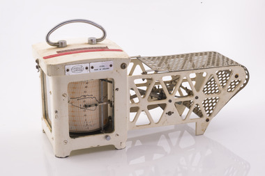
Thermo-hygrograph
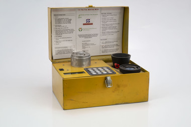
... Forest measurement...) Forest measurement Casella London 10186 Made in England Research ...Bushfire behaviour is influenced by many factors including temperature, relative humidity (RH), forest type, fuel quantity and fuel dryness, topography and even slope. Wind has a dominant effect on the Rate of Spread (ROS), as well as fire size, shape and direction. Temperature and relative humidity have major impacts on fuel dryness and therefore upon the availability of fuel for combustion. A thermo-hygrograph measures and records both temperature and humidity. It produces a continuous record by drawing ink traces on a paper chart held in revolving cylinder. Humidity is measured by shortening or lengthening of a bundle of specially treated human hair. Temperature is measured by means of a laminated bi-metal strip of temperature-sensitive metals which bend differentially with temperature change. The recording drum is driven by clockwork which may be geared for rotation intervals of daily, weekly or monthly periods. This particular instrument is a seven-day recorder. Serial number 10186 which probably dates from about 1960. The chart indicates it was last used in March 1979.Used for bushfire research.Clockwork Thermo-hygrographCasella London 10186 Made in England Research Branch. Forests Commission Orbostbushfire, forests commission victoria (fcv), forest measurement -
 Department of Energy, Environment and Climate Action
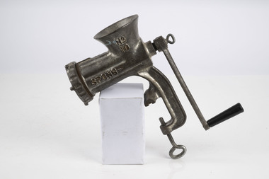
Spong Fuel Mincer
... Forest measurement...) Bushfire Forest measurement Spong No 10 food mincer Spong Fuel ...Used to prepare fuel samples to measure their moisture content. Representative samples of fine fuel such as bark, leaves, twigs etc were minced first through a course mincing plate, then a fine plate and the moisture content measured with a Speedy moisture meter or other device. The availability of fuel to burn depends largely on its moisture content. When it exceeds 20-25% not much will burn, whereas 12-15% is generally ideal for fuel reduction burning, but if the moisture content drops as low as 7-10% virtually everything will ignite, and fire behaviour becomes extreme. During the afternoon of the Ash Wednesday bushfires on 16 February 1983 fuel moisture contents were recorded at Stawell as low as 2.7%. Fine fuels like leaves and bark can rapidly absorb moisture after a shower of rain, or from the air when the Relative Humidity (RH) is high, and the temperature is low. Conversely, they can also dry out very quickly. So even though the overall fuel quantity in the forest doesn’t change, the fine fuel availability can increase rapidly from zero after rain to many tonnes per hectare as the fuel dries out. This can happen over a few hours on hot and windy days. Heavy fuels like logs on the ground take longer to dry out. Spong No 10 food mincerforests commission victoria (fcv), bushfire, forest measurement -
 Department of Energy, Environment and Climate Action
Prototype fuel moisture meter
... Forest measurement... Commission Victoria (FCV) Bushfire Forest measurement T-H Fine Fuel ...Bushfire behaviour is influenced by many things including temperature, relative humidity, forest type, fuel quantity and fuel dryness, topography and even slope. Wind has a dominant effect on the Rate of Spread (ROS), and also bushfire size, shape and direction. Fuel arrangement is as important as fuel quantity (tonnes/ha). Fibrous and ribbon bark, together with elevated and near-surface scrub fuels act as ladders which lead flames into the tree canopy. But the availability of fuel to burn depends largely on its moisture content. When it exceeds 20-25% not much will burn, whereas 12-15% is generally ideal for fuel reduction burning, but if the moisture content drops as low as 7-10% virtually everything will ignite, and fire behaviour becomes extreme. During the afternoon of the Ash Wednesday bushfires on 16 February 1983 fuel moisture contents were recorded at Stawell as low as 2.7%. Fine fuels like leaves and bark can rapidly absorb moisture after a shower of rain, or from the air when the Relative Humidity (RH) is high, and the temperature is low. Conversely, they can also dry out very quickly. So even though the overall fuel quantity in the forest doesn’t change, the fine fuel availability can increase rapidly from zero after rain to many tonnes per hectare as the fuel dries out. This can happen over a few hours on hot and windy days. Heavy fuels like logs on the ground take longer to dry out. Since the 1930s foresters, firefighters and researchers have been working to develop quick and reliable techniques for measuring fuel moisture content. One of the most accurate methods is slowly drying a sample of fuel in a conventional oven for 24-48 hours to remove all the moisture and measuring the weight difference, but this takes time and is not practical in the field when rapid measurements are needed. But oven drying is often used as a benchmark to compare other methods. Microwave ovens are faster but can cause uneven drying and even char the fuel. They are also not very practical for use in the field. Some mathematical models rely on weather records such as rainfall, wind speed, evaporation, cloud cover, shading, relative humidity, slope, aspect and season of the year to predict soil and fuel moisture. The Keetch-Byram Drought Index of soil dryness is the most common. But complex fuels with leaves, twigs, grass etc make the predictive models often inadequate for fine fuels. The most common technique in Victorian forests until recently was the trusty Speedy Moisture Meter. Originally developed in England during the 1920s for measuring moisture in wheat and other grains it was adapted for Australian forest fuels in the 1950s (I think). Fuel was first ground using a Spong mincer, often attached to the bullbar of a vehicle, and a small sample placed into the Speedy together with a measure of calcium carbide and then sealed. A chemical reaction created gas pressure which was read on the external dial. There were important techniques with cleaning, mincing and using the chemicals with the Speedy to give reliable readings, but it was quick, inexpensive, robust, portable and practical in the field. It was used routinely before igniting a fuel reduction burn or measuring fuel moisture differentials on slash burns. But in about 1996, Karen Chatto and Kevin Tolhurst from the Department’s Creswick Research Station developed the Wiltronics Fuel Moisture meter which measured electrical resistance. Wiltronics is an Australian owned company operating from Ballarat. The final result was a kit that was portable, accurate and could reliably measure fuel moisture contents between 3% and 200%. Although expensive, it is now widely used by fire agencies around the world which has virtually relegated the Speedy to the back cupboard.Prototype Fuel moisture meterT-H Fine Fuel Meterforests commission victoria (fcv), bushfire, forest measurement -
 Department of Energy, Environment and Climate Action
Timber moisture meter adapted for forest fuels
... Forest measurement.... So even though the overall fuel quantity in the forest ...Representative samples of fuel such as bark, leaves, twigs etc were minced and the moisture measured The availability of fuel to burn depends largely on its moisture content. When it exceeds 20-25% not much will burn, whereas 12-15% is generally ideal for fuel reduction burning, but if the moisture content drops as low as 7-10% virtually everything will ignite, and fire behaviour becomes extreme. During the afternoon of the Ash Wednesday bushfires on 16 February 1983 fuel moisture contents were recorded at Stawell as low as 2.7%. Fine fuels like leaves and bark can rapidly absorb moisture after a shower of rain, or from the air when the Relative Humidity (RH) is high, and the temperature is low. Conversely, they can also dry out very quickly. So even though the overall fuel quantity in the forest doesn’t change, the fine fuel availability can increase rapidly from zero after rain to many tonnes per hectare as the fuel dries out. This can happen over a few hours on hot and windy days. Heavy fuels like logs on the ground take longer to dry out. Adaption of a timber moisture meter made by the FCV radio lab to measure fuelforests commission victoria (fcv), bushfire, forest measurement -
 Eltham District Historical Society Inc
Slide - Photograph, Unidentified significant tree, Eltham district, c.Feb. 1993
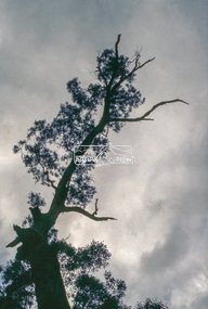
Possibly the Yellow Box, Eucalyptus melliodora, Laughing Waters Road, Eltham 80 m from Reynolds Road http://vhd.heritagecouncil.vic.gov.au/places/71057 Outstanding size Outstanding specimen Located 80m from Reynolds Road, this tree is one of the few remaining forest trees that covered the area before settlement. Measurements: 11/1981 Spread (m): 23 Girth (m): 4.3 Height (m): 42 Estimated Age (yrs): 250+ Condition: Good Measurements: 20/09/2010 Spread (m): EW 20 NS 23 Girth (m): 4..5 Height (m): 40 Estimated Age (yrs): 250+ Condition: Access: Unrestricted Classified: 17/02/198335mm colour positive transparency (1 of 3) Mount - Kodak Ektachromeunidentified, significant tree -
 Bendigo Military Museum
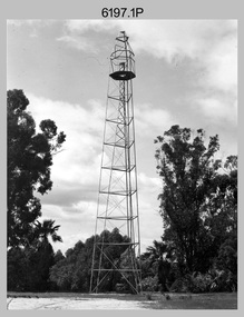
Photograph - Royal Australian Survey Corps Survey Observation Towers, c1950s
This is a set of seven photographs of Royal Australian Survey Corps surveyors setting up observation towers in the field and undertaking survey observations during mapping and geodetic control operations. c1950s. Survey observation towers were used mainly to take angular measurements in flat or heavily forested terrain, where height was necessary to achieve observer’s line-of-sight between field survey station. The Bilby Tower seen in photo .5P was erected to a height of 75 feet (23m) above ground level. The use of the Bilby Tower in Topographic Squadron’s field survey operations from 1955 to 1966 is described in page 54 of Valerie Lovejoy’s book 'Mapmakers of Fortuna – A history of the Army Survey Regiment’ ISBN: 0-646-42120-4. CAPT George Ricketts’ period of service was from 1942 to 1976 reaching the rank of LTCOL. It is noted in page 35 of Valerie Lovejoy’s book that then SGT Ricketts hand lettering skills came to the fore from his contribution to the draughting of one of the Japan’s Instruments of Surrender in 1945.This is a set of seven photographs of Royal Australian Survey Corps surveyors setting up observation towers in the field and undertaking survey observations during mapping and geodetic control operations. c1950s. The photographs were printed on photographic paper and are part of the Army Survey Regiment’s Collection. The photographs were scanned at 300 dpi. .1) - Photo, black & white, c1950s, ‘Bilby’ survey observation tower. .2) - Photo, black & white, c1950s, CAPT George Ricketts climbing ‘Bilby’ survey observation tower. .3) - Photo, black & white, c1950s, geodetic survey equipment on ‘Bilby’ survey observation tower. .4) - Photo, black & white, c1950s, two unidentified field surveyors on ‘Bilby’ survey observation tower. .5) - Photo, black & white, c1950s, two unidentified field surveyors, with CAPT Ricketts climbing ‘Bilby’ survey observation tower. .6) - Photo, black & white, c1950s, two unidentified field surveyors undertaking observations on survey observation tower. .7) - Photo, black & white, c1950, two unidentified field surveyors erecting or dismantling a survey observation tower..1P with paper tag annotated ‘Bilby Tower’ .4P on back – ‘Bilby Tower’. .5P on back – ‘Survey Observing Tower. Observing tower used for angular measurement in flat country. 75’ high – CAPT Ricketts climbing. .6P, .7P on back. ‘1960s?’royal australian survey corps, rasvy, army survey regiment, army svy regt, fortuna, asr, surveying -
 Department of Energy, Environment and Climate Action
Data modem
used to transfer field measurement data to Melbourne for processingMoore Reed Acoustic couplerForests Commission Victoria Assessmentforests commission victoria (fcv), communications, surveying, mapping, assessment