Showing 416 items
matching grampians ranges
-
 Halls Gap & Grampians Historical Society
Photograph - B/W
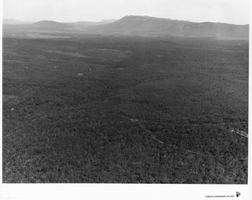
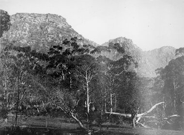
... Grampians Ranges... by Forests Commission SCENERY Grampians Ranges Large, densely treed ...Photo is of Victoria Valley with Moora Moora Reservoir and the Victoria Range in the background. Photo would have been taken from around Reed's lookout area. Photo typical of promotional photos of the time by Forests CommissionLarge, densely treed valley with a body of water in background. Some roads can be seen particularly right foreground. There is a mountain range in the background. c1960sscenery, grampians ranges -
 Halls Gap & Grampians Historical Society
Photograph - B/W
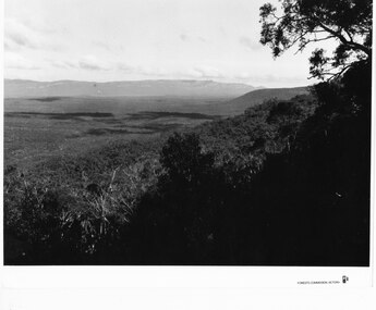
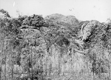
... Grampians Ranges... at that time. SCENERY Grampians Ranges a thick bush covered valley ...Photo is of Victoria Valley with the Victoria Range in the background. Photo is typical of promotional photographs taken by Forests Commission at that time.a thick bush covered valley in foreground (shadowed). Mountain range in background. Photographed from a high spot looking down and across the valley. c1960sscenery, grampians ranges -
 Stawell Historical Society Inc
Painting, Will Rees, "Evening Shadows" of Stawell Victoria Aug, 1929
... Framed painting of field trees and Grampians Range... of field trees and Grampians Range in background. Houses ...Framed painting of field trees and Grampians Range in background. Houses in distance and what may be a smokestack. 1929To Robert Rees Morcom on his 21st Birthday May 1934. From his Grandfather Will Rees and aunt Elsie Rees. -
 Warrnambool and District Historical Society Inc.
Leisure object - Sheet Music, My Grampian Rose, 1940s
... situated close to the Grampians mountain range and the title... having a multi-coloured illustration of the Grampians mountain... situated close to the Grampians mountain range and the title ...This is a waltz piece of music with words and music by Ruby Wharrie. Mrs Wharrie is best known for her doll-making business which she operated in Stawell, Victoria with her husband and son. Mrs Wharrie was the designer of the dolls which were made in the 1940s and 50s. One doll was named ‘Shurl’ to cash in on the popularity of the child actress Shirley Temple and the consequent popularity of the Shirley Temple doll. Stawell is a provincial city situated close to the Grampians mountain range and the title of the music reflects Mrs Wharrie’s interest in the area. ‘My Grampian rose’ is a person and the theme of the music is the fulfilment of love - ‘I am coming back to you, my little Grampian Rose’. This music is of interest as it has been written by a person who lived in western Victoria. It has Ruby Wharrie’s signature inside the front cover, making it more valuable. It is also an example of the sweet and sentimental music produced during the 1940s and 50s as a foil to the sadness and brutality of the world war. This is sheet music of four pages (two pages printed back to back) with the printed music on three pages and the cover having a multi-coloured illustration of the Grampians mountain range in Victoria. It is in good condition and has an old catalogue number ‘94’ on the back page. Front cover: ‘My Grampian Rose, Words and Music by Ruby Wharrie, 2/6’ Inside front cover: ‘Ruby Wharrie’ ruby wharrie, my grampian rose, sheet music -
Stawell Historical Society Inc
Book, Kenneth & Esther Stepnell, The Grampians in colour, 1972
... 1972 - Colour photgraphs of Grampians Ranges, Lake...1972 - Colour photgraphs of Grampians Ranges, Lake ...1972 - Colour photgraphs of Grampians Ranges, Lake Bellfield, Fauna, signpost, Halls Gap, Rockart, Flora. Kenneth Stepnell Photographer. Esther Stepnell selected the photographs and wrote the introduction & captions.Hardcover with Dustjacket: Colour photo of a man overlooking a valley with lake Bellfield from the Pinnacle lookout.Inside: Name and address of previous ownergrampians, touruism -
Stawell Historical Society Inc
Book - Report, Grampians National Park Draft Management Plan, 1985
... Soft Cover with B/W Photo of aerial view of ranges... of ranges of Grampians. Black taped Spine binding. Grampians ...For Public comment to National Park Service, Victoria. A Division of the department of Conservation, Forest and LandsSoft Cover with B/W Photo of aerial view of ranges of Grampians. Black taped Spine binding.$5 Barry Clugston -
 Stawell Historical Society Inc
Drawing, Grampians Scenes -- Sketches
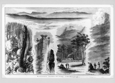
... Holiday Rambles - The Grampians The Sierra Range.... Calvert. stawell Holiday Rambles - The Grampians The Sierra Range ...Very detailed drawings of scenes of the Grampians. Artist S. Calvert.Black and white detail drawings of series of mountain scenes. Holiday Rambles - The Grampians The Sierra Range - Grampians from the Big Hill Stawell. The Descent to the Gap Valley. The Anvil Rock. Barneys Chimney. The "Selection" in the Gap Valley. Only half way up. Reproduction Rights Reserved Copied by State Library of Victoria on the back stawell -
Stawell Historical Society Inc
Book, Victorian national Parks Assn, The Grampians A Noble Range, 1987
... The Grampians A Noble Range Jane Calder Inside: Belongs...Grampians The Grampians A Noble Range Jane Calder Inside ...Blue card cover with centered Coloured photograph of mountains above cloudsThe Grampians A Noble Range Jane Calder Inside: Belongs to DR. R Handscombe. PO Box 63 Willauragrampians -
Stawell Historical Society Inc
Photograph, Aerial Photos of Stawell from a Hot Air Balloon 1992 -- 12 Photos
... & Park 6. Grampians Range with Lake Lonsdale near center 7.... Grampians Range with Lake Lonsdale near center 7. Gold Reef Mall ...Series of 12 Aerial Photos of Stawell. Hot Air Balloon, October 1992 1. Cnr. Maude St & Grant Street 2. Maude St Napier Street & Railway cutting 3. Trotting Track 4. Roundabout Wimmera & Sloane Street 5. Florence Street towards Cato Lake & Park 6. Grampians Range with Lake Lonsdale near center 7. Gold Reef Mall looking West 8. Church Street looking West 9. Looking towards Black Range 10. Moonie Dams Darlington Road Leisure Complex 11. Stawell Gold Mine Evaporations Dams, Stawell Water Reservoirs, Moonie Dams 12. Darlington Road looking towards Black RangeSeries of 12 colour photographs from the Air.stawell -
Stawell Historical Society Inc
Map, Plan of Division Line between Ararat and Stawell Shires 1877, 1877
... Grampians Halls Gap Black Range Stawell Shire Ararat Shire... grampians Grampians Halls Gap Black Range Stawell Shire Ararat Shire ...Grampians Halls Gap Black Range Stawell Shire Ararat Shire Crowlands TownshipVery Large Map Printed on Linen with Table of bearingsExamined by H.C. Malcolm 28.12.77 Traced By D.H. Meike 28.12.77survey -
 Stawell Historical Society Inc
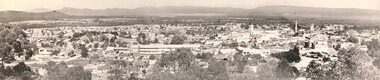
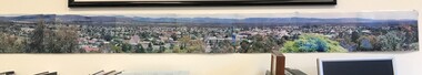
Photograph, Panorama of Stawell from Big Hill c1966
... prominent in photo. Grampians and Black Range in background. Visible... prominent in photo. Grampians and Black Range in background. Visible ...1966 Panorama from Big Hill. New technical school prominent in photo. Grampians and Black Range in background. Visible are St Patrick's Church, Kinsella, Nalders Garage, Town Hall, St Matthews, Upper Main Street. Trees in foreground.Panorama of Stawell from Big Hill in 1966Magnificent View of Stawell from Big Hill c 1966stawell, education, panorama, streetscape -
 Stawell Historical Society Inc
Photograph, Wonderland Range in the Grampians 1866
... Grampians (Wonderland Range). Part of a collection...Grampians (Wonderland Range). Part of a collection ...Grampians (Wonderland Range). Part of a collection of Photographs by Mr. O.G. Armstrong as commissioned by the Shire of Stawell for the Inter-colonial and Paris Exhibition in Melbourne in 1866. The Grampians, with its wildflowers and rock formations, have attracted people from all parts of the world for many years and have always been promoted strongly by local groups. One such group was the Grampians Tourist Association, formed in 1901. Wonderland would probably be the best known part of the whole area, noted for its rugged and weather worn rock formations and spectacular views, too numerous to mention. The Grampians are now a National Park. stawell -
 Stawell Historical Society Inc
Photograph, Panorama of Stawell from Big Hill c 1998 -- Coloured
... . Black Range and Grampians visible in background. Panorama photo.... Black Range and Grampians visible in background. Panorama photo ...Colour Panorama of Stawell c 1998 Overlooking Stawell. Black Range and Grampians visible in background. Panorama photo was taken by Irene Read for Barbara Bennet, a member of the "Big Hill Action Group" The group were fighting Stawell Gold Mines proposal to "Open Pit" the Big Hill area. SGM was at that time owned by an American Company - Pitston-Brinks. Laminated panorama of Stawell from Big Hill c 1998 -- Coloured photographs producing a panorama of Stawell. stawell, panorama -
 Stawell Historical Society Inc
Photograph, Wonderland Range in the Grampians at Halls Gap 1866
... Grampians Halls Gap (Wonderland Range). Part...Grampians Halls Gap (Wonderland Range). Part ...Grampians Halls Gap (Wonderland Range). Part of a collection of Photographs by Mr. O.G. Armstrong as commissioned by the Shire of Stawell for the Inter-colonial and Paris Exhibition in Melbourne in 1866. Although little is known of the lifestyle of the Grampians, Aborigines. Evidence of their thousands of years occupation exists in the form of campsites and Ochre and Pipeclay drawings on the smooth surfaces of rock shelters. There are 40 or more aboriginal art galleries known to be in the Grampians, most of which have been discovered in the past 25 years. Some of these shelters are accessible to visitors. stawell -
 Flagstaff Hill Maritime Museum and Village
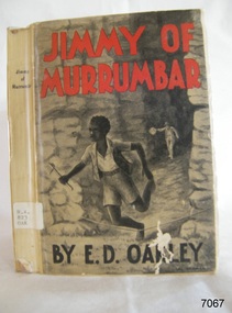
Book, Jimmy of Murrumbar, circa 1938
... and mountain region of the Grampian Ranges of Victoria. Oakely's... australian bush grampian ranges in victoria warrnambool history ...This novel, Jimmy of 'Murrumbar' by E.D. Oakley (Edward Daniel Oakley 1877-1962), is a children’s adventure story about an Australian indigenous boy who was educated in a mission and worked as a 'black tracker’ for the police to hunt down criminals in the bush and mountain region of the Grampian Ranges of Victoria. Oakely's parents, Thomas and Eliza, had a farm in Warrnambool called 'Oakbank'. Oakley worked at various jobs in the local district and later had his own wheat farms. When he returned to Warrnambool to build commercial premises and work in the retail industry. His influence encouraged Fletcher Jones to open a shop in Warrnambool. His novel - Jimmy of 'Murrumbar' - was written after he retired. The copy of the book in our collection does not have a publication date. The National Library of Australia lists two editions of this book, one dated 1938, the other is undetermined. It was published as part of a series called the Marcie Muir Collection of Australian children's books. No reference has been found to the author or any further works by him/her. The novel was reprinted as a reproduction in 2017 as a paperback and a leather bound edition 'Classic Reprint' by Forgotten Books. WARRNAMBOOL MECHANICS’ INSTITUTE Warrnambool's Mechanics' Institute (or Institution as it was sometimes called) was one of the earliest in Victoria. On 17th October 1853, a meeting was held where it was resolved to request the Lieutenant Governor of the Colony to grant land for the erection of a Mechanics' Institutes building. A committee was formed at the meeting and Richard Osburne chaired the first meeting of this committee. The land on the North West corner of Banyan and Merri Streets was granted but there were no funds to erect the building. The Formal Rights of the Warrnambool Mechanics' Institute's encompassed its aims and these were officially adopted in1859; "This Institution has for its object the diffusion of literary, scientific, and other useful knowledge amongst its members, excluding all controversial subjects, religious or political. These objects are sought to be obtained by means of a circulating library, a reading room, the establishment of classes, debates, and the occasional delivery of lectures on natural and experimental philosophy, mechanics, astronomy, chemistry, natural history, literature, and the useful and ornamental arts, particularly those which have a more immediate reference to the colony." The Warrnambool Mechanics' Institute opened its first reading room in November 1884 in the National School building at the corner of Banyan and Timor Streets. The Institute was funded by member subscription, payable on a quarterly, half-yearly or yearly basis. Samuel Hannaford, the Manager of the Warrnambool Bank of Australasia, was the first Honorary Secretary of the Mechanics' Institutes, and an early President and Vice-President. He also gave several of the early lectures in the Reading Room. Another early Secretary, Librarian and lecturer was Marmaduke Fisher, the teacher at the National School. Lecture topics included The Poets and Poetry of Ireland', 'The Birth and Development of the Earth', 'The Vertebrae - with Remarks on the pleasures resulting from the study of Natural History' and 'Architecture'. In 1856 the Reading Room was moved to James Hider's shop in Timor Street, and by 1864 it was located in the bookshop of Davies and Read. In the 1860's the Mechanics' Institute struggled as membership waned but in 1866, after a series of fundraising efforts, the committee was able to purchase land in Liebig Street, on a site then called Market Square, between the weighbridge and the fire station. A Mechanics' Institute building was opened at this site in August 1871. The following year four more rooms were added to the main Reading Room and in 1873 the Artisan School of Design was incorporated into the Institute. The same year Joseph Archibald established a Museum; however, it deteriorated when he was transferred to Bendigo in 1877. In 1880, with Archibald's return to Warrnambool, the Museum was re-established, and in 1885 a new building was built at the back of the Institute to accommodate the re-created School of Design, the Art Gallery and the Museum. In 1887 the Museum section was moved to the former courthouse in Timor Street (for some time the walls of the building formed part of the TAFE cafeteria but all is now demolished)). In 1911 the Museum was transferred back to the original building and the management of the Mechanics' Institute was handed over to the Warrnambool City Council. The Museum and Art Gallery became one and housed many fine works of art, and the Library continued to grow. The building was well patronised, with records showing that at the beginning of the 20th century there were between 500 and 800 visitors. During World War One the monthly figures were in the thousands, with 3,400 people visiting in January 1915. The Museum was a much loved Institution in Warrnambool until the contents of the Museum and Art Gallery were removed to make room for the Warrnambool City Council Engineers' Department. The contents were stored but many of the items were scattered or lost. When the original building was demolished the site became occupied by the Civic Centre, which included the new City Library. (The library was temporarily located in the old Palais building in Koroit Street.) In the process of reorganisation the Collection was distributed amongst the community groups: -The new City Library took some of the historical books and some important documents, historic photographs and newspapers. -The Art Gallery kept the 19th Century art collection and some of the artefacts from the museum. -The Historical Society has some items -The State Museum has some items -Some items were destroyed -Flagstaff Hill Maritime Village has old newspapers, Government Gazettes, most of the Mechanics' Institute Library, ledgers and documents connected to the Mechanics' Institute Library, some framed and unframed artworks and some photographs. The Warrnambool Mechanics' Institute Library book collection is deemed to be of great importance because it is one of the few collections in an almost intact state, and many of the books are now very rare and of great value. This novel is historically significant for its story, representing the changes to Australian Indigenous culture and life after colonisation. The book appears to be that this is the only work written by E.D. Oakley. It is locally significant for being written by an early prominent Warrnambool family member. Jimmy of Murrumbar : A Story of the Amazing Ability and Fidelity of an Australian Black Tracker Author: E D Oakley (Edward Daniel Oakley) Publisher: Osboldstone & Co, Pty Ltd, Melbourne, Australia The label on the spine with typed text R.A. 823 OAK The front loose endpaper has a sticker from Warrnambool Children’s Library shipwrecked-coast, flagstaff-hill, flagstaff-hill-maritime-museum, warrnambool, maritime-museum, shipwreck-coast, flagstaff-hill-maritime-village, shipwrecked-artefact, book, pattison collection, warrnambool library, warrnambool mechanics’ institute, ralph eric pattison, corangamite regional library service, warrnambool city librarian, mechanics’ institute library, victorian library board, warrnambool books and records, warrnambool children’s library, jimmy of murrumbar, e d oakley, edward daniel oakley, novel, young adult novel, juvenile fiction, australian black tracker, law enforcement - police trackers, tracking and trailing in australia, australian bush, grampian ranges in victoria, warrnambool history, fletcher jones, oakbank, thomas and eliza oakley, indigenous literature, indigenous australians -
 Nhill Aviation Heritage Centre
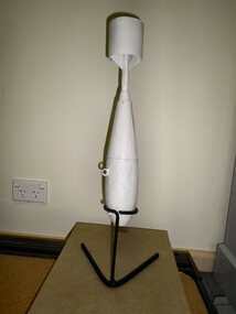
Practice Bomb Replica, c1940
Part of a navigator's training was to practice bomb aiming. These bombs detonated a liquid causing a thin spiral of smoke to rise from the impact point. Thousands were dropped near Nhill.At the end of WWII thousands of the remains of these bombs were removed for recycling. Very few remain as an example of those used during training.This is a reasonable replica of an original smoke bomb used during practice on the bombimg range south of Nhill.No markingsbomb, bomb replica, practice bomb -
 Nhill Aviation Heritage Centre
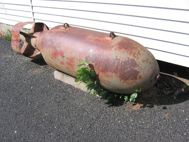
2000 lb Bomb
This bomb was found on the Bombing Range during the late 1950s.Very few of these bombs were known to have been dropped at Nhill and this is one of only two known to have been recovered unexploded.cylindrical body with rounded nose, plate steel tail fins, fuse fitting on the nose bomb, 2000 pound, bombing range -
 Nhill Aviation Heritage Centre
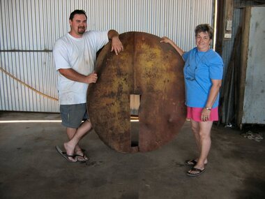
Target, 1941
This was the main target used for bombing and strafing practice during WWII by trainees at the RAAF Air School at Nhill.Original target from the bombing range. Other temporary wooden targets were used but this is the only original target that now exists.This target is made of 10mm steel plate. Two circles approximately 1.5 metres in diameter are slotted and joined at right angles so that when viewed from a distance would always appear as a round ball. Includes four support stays approx. 14 foot long 3" steel pipe with flattened ends.It is marked in several places due to being hit by bombs.target, -
 Nhill Aviation Heritage Centre
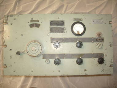
Equipment - Radio Receiver BC-639A, 1940-1949
The BC-639A is a ground based AM VHF receiver covering the nominal frequency range of 100 -156 m/cs. The set was built for the U.S. Army Air Force in WW2 as part of a communication system to communicate with aircraft. A system of similar intent was built in Australia during WW2 by Radio Corporation of Victoria (ASTOR), with the addition of FM facilities. This system used the ARl7 receiver and ATl7 transmitter. Many of the sets had been modified after the war by the then Dept of Civil Aviation for use as monitoring receivers.This type was used at the AeradioThe BC-639A is a ground based AM VHF receiver covering the nominal frequency range of 100 -156 m/cs. The set was built for the U.S. Army Air Force in WW2 as part of a communication system to communicate with aircraft. Dark grey US Military colourradio receiver, bc 639, bc 639a, 639, aeradio -
 Nhill Aviation Heritage Centre
Instrument - Barometer, Aneroid Barometer, c1960s
Precision instrument used meteorological offices on air fields to measure barometric pressure141.1 Metal cube shape instrument with button switch attached is a cylindrical read out and adjuster knob. 141.2 Carry box with hinged lid and metal latch, has three hold down screws. 141.3 Stainless steel and glass thermometer 141.4 batteries 4x 15v. Standard batteries were HT Eveready B123 30v x3, LT Eveready LLII 1.5 v x1Aneroid Barometer, Type No. M.1991/A Range 800-1050mb. Ser No. 686/65, Mechanism Ltd, Made in Englandbarometer, instrument, aneroid barometer, thermometer -
 Halls Gap & Grampians Historical Society
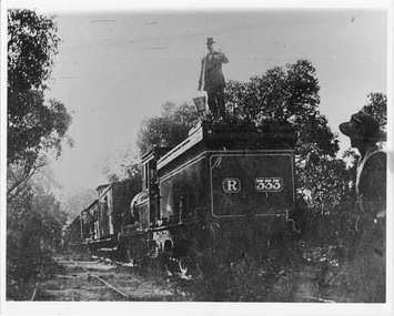
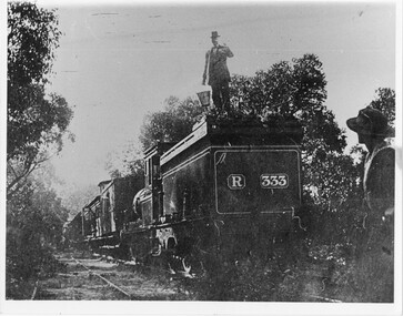
Photograph - B/W, C 1882
Occasional picnic trains took large groups of visitors to the base of the mountain range & sometimes as far as the quarry. Other journeys terminated at Fyans Creek station on the south side of Mt Dryden. Most trips were Sunday School & Church outings, some on the annual Good Friday picnic. Spring was also a popular timePhoto shows train at siding. Man standing on engine roof with bucket in hand; woman in right hand corner of photo looking on; passenger looking out of open doorway. R333 written on back of engine car. Engine turned back to fronttransport, trains -
 Halls Gap & Grampians Historical Society
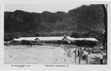
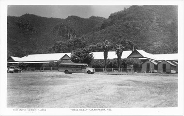
Postcard - Sepia, 21/12/1925
Bellfield' formerly a guest house was opened as a licenced hotel in 1924 A message was written on the back of the post card and dated 21/12/25Bellfield with the Wonderland Range behind Hand written message on reverse side dated 21/12/25 The Rose Series P 4914 Message reads: "To my Dear Friend Thanking you for your dear little letter and pretty card and good wishes We all wish you a very Happy New Year I do wish you were here to [2 words cant read] lots of love from your loving friendaccommodation, hotels, bellfield -
 Halls Gap & Grampians Historical Society
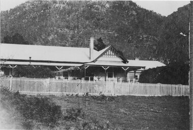
Photograph - B/W, 1920-1930
During the period 1924-1967 Bellfield operated as a licenced hotel. It became a popular destination for couples on their honeymoon The hotel was razed to the ground by fire in 1967 and was never rebuilt. The Grampians Motel now occupies the sitephotograph shows right hand section of Bellfield Hotel with woman on verandah to the right of bare tree Wonderland Range behindcopy done by AGFA Dec 99accommodation, hotels, bellfield -
 Halls Gap & Grampians Historical Society
Postcard - B/W, 1950
By 1950 Hotel Bellfield was owned by Mr and Mrs McMullin In June 1952 the staff quarters at the rear of the main building was destroyed by fire. As the staff accommodation comprised seven detached bungalows, similar to those in the photograph, it was possible to isolate the fire from spreading to the main building.Guest house with bus in foreground Wonderland Range in backgroundThe Rose series P 4894 copies Kodak Picture maker, Agfaaccommodation, guesthouses, bellfield -
 Halls Gap & Grampians Historical Society
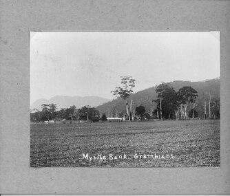
Photograph - B/W, C 1912- 1914
Residence of Warren family overlooked by Upper Halls Gap range Site now under Lake BellfieldBuildings of Myrtlebank overlooking paddock Back drop Upper Halls GapPhoto mounted on cardboardbuildings, houses, myrtlebank -
 Halls Gap & Grampians Historical Society
Photograph - B/W, C 1882
Occasional picnic trains took large groups of visitors to the base of the mountain range & sometimes as far as the quarry. Other journeys terminated at Fyan's Creek station on the south side of Mt. Dryden. Most trips were Sunday School & church outings - some on the annual Good Friday picnic day. spring was also a popular time.Photo shows train at siding. Man standing on engine roof with bucket in hand; woman in right-hand corner looking on; passenger standing at open carriage door. R 333 written on back of engine car. Engine turned back to front.transport, trains -
 Halls Gap & Grampians Historical Society
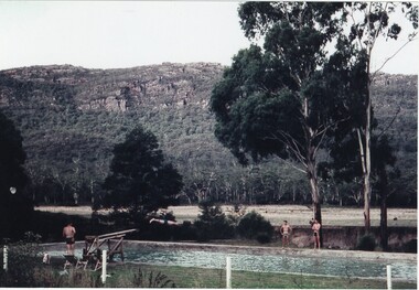
Photograph - Coloured, C 1960
Jack Deller at end of diving board Graeme Chappell diving off of board Darryl Williams left and Doug Bottoms right opposite side of pool Occasion was Graeme's 21st birthdayPeople enjoying pool and diving board at Myrtlebank Guest House overlooked by Mt William Range.AGFApeoplerecreation, sport -
 Halls Gap & Grampians Historical Society
Magazine - B/W, C 1915
Large families were the norm, rather than the exception up to the time of the World wars. perhaps the senseless destruction of those young lives sickened humanity- perhaps the increased taxes and cost of living resulting from the wars caused a necessary reduction in family size. Perhaps the independence won by women as they carried on their daily lives without their men, made mothers say, "Enough" The Warren family farmed the fertile Fyans Creek flats in the Grampian Mountains of Western Victoria. Some say Halls Gap was so named because the bushranger Hall holed up there in the early days. The rugged slopes and hidden gullies could have hidden a whole gang of bushrangers, but little remained undiscovered to a wandering family of 12 children growing up with their flocks and herds grazing the ranges. A tired rider could nod off, safe in the knowledge a trusty stockhorse would plod steadily homeward into the night. Responsibility quickly made youngsters capable and reliable. Then Australia went to war. There were three older brothers, then the girls, then young Frank. All the men went, including Frank. So the girls had to run the farm alone. Their mother had her hands full with the youngsters, still attending school, a daily walk over the mountain to Pomonal and return. But the loss of the men's casual wages from timber cutting and labouring jobs, meant great hardship is some method of earning a cash income had to be devised. Paying guests! That was it. So Myrtle Bank Guest House was born. City folk flocked to the mountain resort. High stepping mountain horses met them at the Stawell raid-head, with the tall and beautiful Warren girls driving them in experienced fashion, their auburn hair sometimes falling from its pins to fly free, as the dray bowled along towards the hills. The would hitch up their skirts to saw and chop wood for the stoves and fires. They milked cows and delivered calves. They shore sheep and trimmed their feet. They mustered their cattle as the seasons rolled by, and the paying guests watched and participated, fascinated. With laughter and song, the girls would wash up in a tin dish, throw on their house clothes to wait on table, sing and play piano, violin, accordion, enjoying the talk of the city and that other world so far away from their mountain home. The simple country menu was a hit, and the homemade bread, butter, jams and preserves, fruit and vegetables sent guests staggering to their armchairs. Picnics, hikes, goodbyes and welcomes blurred as the years of the war dragged by. Bookings were made and remade as the new enterprise became established. Peace was declared. the men returned A whole new building rose with two floors, inviting verandahs and bathrooms. Myrtle Bank would remain a family business all its lifetime, until buried below the Bellfield Dam, by which time more than one the girls had joined their beloved Frank, lost on Flanders Field. Article in book or magazine describing life at Myrtlebank during war years Other article written from letter from soldier P Lillis to his sister 3rd article of woman from country enlisting in WAAF Submitted by Carol of Bannockburn, Submitted by D Langley Submitted by Meryl of South Frankstonaccommodation, myrtlebank, people, warren -
 Halls Gap & Grampians Historical Society
Photograph - B/W, C Dec 1870 / Jan 1871
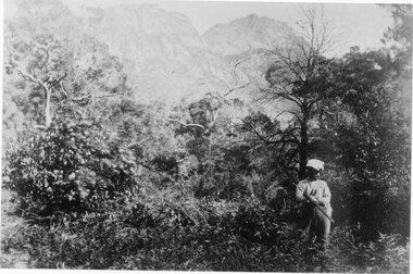
This photo is from a collection by Edward Roper. taken between Dec 1870 and Jan 1871. The man in the photo was one of a party who accompanied Edward Rover (artist) at this time. This activity was described as a hunting party Photo sows man with gun under his arm and standing in thick bush. Ranges behind are those close to Rose's gaprecreation, sport, roses gap -
 Halls Gap & Grampians Historical Society
Photograph - B/W, C 1890
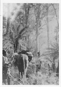
The man with the horse is Charles D'Alton, his cousin Alfred is beckoning him to come on. Charles was ther son of William D'Alton if "Silver Springs" on Dairy Creek, and Fred (Alfred) was the son of John D'Alton, Stawell Borough engineer. Fred and Charles were responsible for finding many of today's walking track routes through the Wonderland Range and in the Mt. Rosea area. The second copy is a transparency (slide) , no. 182 in the slide box.Photo shows man, left side corner with pack horse andother man middle ground with arm raised"Charles D'Alton beckoning to his cousin Alfred to come on" finding the best routegilbert rogers, vehicle track, people, d'alton