Showing 1025 items matching "historical walk"
-
 Orbost & District Historical Society
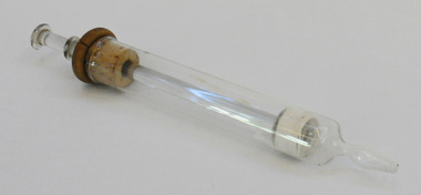
syringe, first half 20th century
This veterinary item was found in a walk-through dairy at Wombat Track, Orbost. It has been identified by vet, Peter Honey (9.1.2015) as possibly used for flushing abscessed or mastitis teats. It could have been improvised for another use by the farmer and was probably originally for medical use.These items are representative of items used in Orbost on dairy farms in the first half of 20th century.A glass syringe-like tube with a glass plunger inside. There is a small hole at one end and a movable plunger at the other end which has a cork collar.veterinary-equipment dairy farming -
 Orbost & District Historical Society
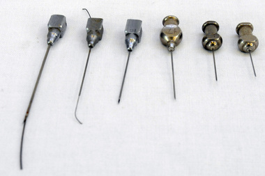
needles, MacGregor Instrument Company, First half 20th century
These veterinary items were found in an old walk-through dairy in Wombat Track, Orbost.These items are representative of items used in Orbost on dairy farms in the first half of 20th century.Six stainless steel needles for use in a syringe.2401.5 has a small length of wire inserted into the needle. 2401.6 also has a small length of wire inserted into the needle.2401.1 : 6 2401.2 : 7(?) 2401.3 : CLINIC 17 2401.4 : 16 2401.5 : S 19 2401.6 : VIM-FIRTH 20dairy farming veterinary-instruments hypodermic-needles -
 Orbost & District Historical Society
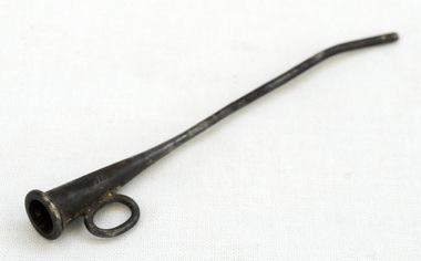
catheter, Mayer & Co, early 20th century
This veterinaary item as found in an old walk-through dairy on Wombat Track, Orbost.These items are representative of items used in Orbost on dairy farms in the first half of 20th century.A very small trumpet-shaped funnel made of silver/brass(?). It has a loop handle at the funnel end and is bent towards the end for insertion.MAYER & Co LONDON SILVERcatheter veterinary-instrument dairy farming -
 Orbost & District Historical Society
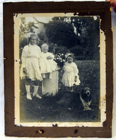
photograph, 1910 ?
George Nixon (1862-1941) selected land in Bete Bolong in the 1890's. He married Emily Warren in 1889 in Orbost. He was a shire councillor. He was a prominent breeder of Clydesdales and after a serious fall off a horse walked with a walking stick and special boot for the rest of his life. He was well-known for his interest in cars, horse-racing and politics. Mrs Nixon (Emily)was the first Red Cross president during WW1. They had ten children.both George and Emily are buried in the Orbost Cemetery. (ref:From White Knowle to Pumpkin Point by Hon Peter Nixon A.O.)George Nixon was the son of James and Alice Nixon. The Nixon families were among the earliest settlers on the Snowy River.A large black and white photograph which is glued on to a white paper frame and then on to brown cardboard. It is a photo of three children and a dog standing in a garden with a house in the background. The smallest child is sitting on a planter pedestal. The baby is Frederick Howard Nixon, the older girl is Essie Nixon.On back - George & Emily Nixon's family (Warren) Lexcine, Frederick, Esther In bottom RH corner - HDBphotograph family nixon-george -
 Orbost & District Historical Society
coloured photograph
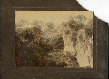
There is no information with this item. "The Pyramids", was named due to huge rocks that jut out from the hill, being shaped similarly to the Egyptian Pyramids. " Where the Murrindal River winds between high limestone bluffs before disappearing into a mountainside and becoming an underground river, four miles north-east of Buchan, is the region known as The Pyramids. It is an area of limestone caverns and sink holes overshadowed by three rock stacks. Some of the caves are the last resting places of long dead Murrindal animals." ( from MBW Walk magazine 1970 - Melbourne Bushwalkers"A hand-painted colour photograph of a view of mountain ranges with men on horses in the background.on front - "Pyramid Gorge Buchan"pyramid-gorge-buchan murrindal limestone-caves -
 Orbost & District Historical Society
black and white photograph
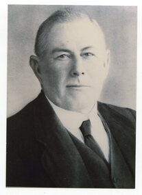
This is a photograph of Councillor George Nixon who represented South Riding on the Orbost Shire Council from 1902 - 1916. He was president 1914-1915. George Nixon (1862-1941) selected land in Bete Bolong in the 1890's. He married Emily Warren in 1889 in Orbost. He was a shire councillor. He was a prominent breeder of Clydesdales and after a serious fall off a horse walked with a walking stick and special boot for the rest of his life. He was well-known for his interest in cars, horse-racing and politics.He was married to Emily Warren in 1889 in Orbost. Mrs Nixon (Emily)was the first Red Cross president during WW1. They had ten children.both George and Emily are buried in the Orbost Cemetery. (ref:From White Knowle to Pumpkin Point by Hon Peter Nixon A.O.)This item is associated with the Orbost Shire Council. The shire covered an area of 9,347 square kilometres and existed from 1892 until 1994 when it became part of the East Gippsland Shire Council. This item is associated with a prominent Orbost family. George Nixon was the son of James and Alice Nixon. The Nixon families were among the earliest settlers on the Snowy River.A black / white head and shoulders portrait photograph of man wearing a suit.There is also a framed copy.nixon-george orbost-shire-council -
 Orbost & District Historical Society
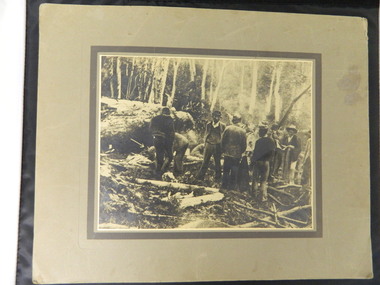
raker saw, c 1880 - 1940
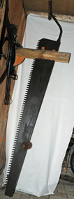
Used in the timber industry in the Orbost district. This is a two person operated cross cut saw which functions as a pit saw. A log is placed over a pit lengthways. The man on the top walks along the log and pulls the saw upwards, and he man below pulls the saw downwards. This saw therefore cuts in both directions. This type of saw was often used in the ship building industry for cutting planks.A long raker saw which has been installed into the Slab Hut Shed in a vertical position as a pit saw. It has a metal handle extension at the top which has a wooden handgrip attached. Towards the bottom of the saw, a wooden handle had been added to the saw. timber-industry-tool raker-saw pit-saw -
 Orbost & District Historical Society
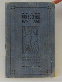
Book, Published byThe High School Teachers' Association of Victoria. Printed by Morris & Walk Pty Ltd.er, High School Song Book, 1914
Used by Nance Gilbert, Orbost.This is a useful research tool.A blue covered book of songs with music and lyrics. Edited by Frederic Earp, Melbourne High School.In back is a handwritten song with notes below. On fly at front handwritten in red ink is : "Nance Gilbert".book music education earp-frederic -
 Phillip Island and District Historical Society Inc.
Photograph - Post Cards, Rose Series et al, Phillip Island
Part of a collection of Postcards donated by Mary Karney450-04 to 450-16 - Part of a collection of photograph postcards from Mary Karney collection.back beach phillip island, the nobbies phillip island, lover's walk cowes, rhyll, smiths beach, newhaven, mary karney -
 Phillip Island and District Historical Society Inc.
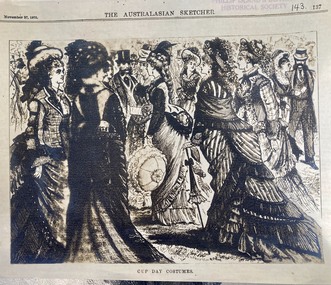
Article, The Australasian Sketcher 1875 'Wollamai wins the Melbourne Cup ", November 27 1875
The racehorse 'Wollamai" [ or Wollemi ] was bred and trained on Phillip Island by John Cleeland on Phillip Island. It won the Melbourne Cup in 1875. John Cleeland walked the horse to Melbourne to compete.Historical3 photocopies of an article from the sporting section of the Australasian Sketcher describing the Spring meeting of the Victorian Racing Club, large illustration of the crowd and costumes. Article describes the races, horses in very small print.The Australasian Sketcher Sport November 27 1875wollomai, melbourne cup, john cleeland, horse racing, wollemi -
 Phillip Island and District Historical Society Inc.
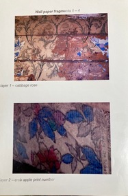
Mixed media, Wallpaper samples from Charmandene Guest house
Title of property shows the property was owned by Emily Henty in 1894. " Charman Dene" was Alfred Herbert and Edith Blanche Holdsworth’s holiday house. The property was sold following Alfred Herbert’s death in 1929. Mrs Champion later owned the property. Charmandene Guest House was located on the beach front along Lover's Walk. It was relocated in the 1980s to Osborne Road in Cowes , where it still stands.HistoricalTwo sheets of photos of original wallpaper and a sample of coloured floral wallpaper, "crab apple"Wall paper fragments 1-4, layer 1 - cabbage rose, layer 2 - crab apple print number, layer 2- crab apple border, layer 2 - crab apple wall,charmandene cottage, guesthouses, home decor -
 Phillip Island and District Historical Society Inc.
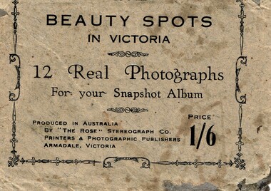
Postcard, Beauty spots in Victoria
Tourist photographs of Phillip IslandHistoricalSmall black and white photos of scenes of Phillip Island including the jetty, beach, Nobbies and ferries. Enclosed in a beige paper envelope.Beauty spots in Victoria. 12 Real Photographs for your Snapshot Album. Produced in Australia by The Rose Stereograph Co. Price 1/6 1. The Pier, Cowes, 2. Front beach, Cowes, 3. Alvina & Genista at pier, $. Koala in tree, 5. beach near Nobbies, 6. The Nobbies, 7. The Pinnacles, 8. Looking out at Forest caves, 9. Lovers Walk - Cowes, 10. Forest Cave, 11. The road to back beach, 12. The beach & pier, Cowes.the nobbies, ferries, cowes jetty, forrest caves, phillip island, black & white postcard copy, photographs -
 Orbost & District Historical Society
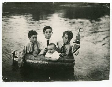
black and white photograph, Warren, Mrs H, first half 20th century
This is a photograph of Alan, Keith, Preston and Jim Nixon. George Nixon (1862-1941) selected land in Bete Bolong in the 1890's. He married Emily Warren in 1889 in Orbost. He was a shire councillor. He was a prominent breeder of Clydesdales and after a serious fall off a horse walked with a walking stick and special boot for the rest of his life. He was well-known for his interest in cars, horse-racing and politics.He was married to Emily Warren in 1889 in Orbost. Mrs Nixon (Emily)was the first Red Cross president during WW1. They had ten children.both George and Emily are buried in the Orbost Cemetery. (ref:From White Knowle to Pumpkin Point by Hon Peter Nixon A.O.) The photographer was Warren, Helena (1871-1962) who was a self-taught photographer who became both the local press correspondent and a producer of humorous trompe l'oeil postcard images. Helena Warren was a thirty-two year old settler living on a small mixed farm with her husband, William, at Newmerella, near Orbost in Gippsland, Victoria, when she bought her first camera, an Austral Box quarter-plate. Her family says she was entirely self-taught, like many women photographers who started out with nothing but the instructions on the packets of film and chemicals. In over fifty years practice she graduated from the total novice, who opened all her first mail order plates in bright sunlight and ruined them, to a competent photographer who became both the local press correspondent and an inveterate producer of humorous trompe l’oeil postcard images.This photograph has significance in its association with Helen Frances Warren, a popular Orbost identity who was well known as an accomplished photographer and needleworker, This item is also associated with a prominent Orbost family. George Nixon was the son of James and Alice Nixon. The Nixon families were among the earliest settlers on the Snowy River. It is an example of the early book-keeping of an Orbost business in the early 20th century.A black / white photograph of three boys and a baby in a carved out pumpkin with a flag at each end and "HMAS ORBOST" carved in the front.warren-helena pumpkins nixon -
 Ringwood and District Historical Society
Pamphlet, Maroondah City Council, Ringwood Central - Historic Walk, c. 2000
Produced by Maroondah City Council, sponsored by the Maroondah Tourism Advisory Board from notes by courtesy of the Ringwood Archives.Ringwood Central - Historic Walk. White bifold pamphlet with photographs (12) and map. Explanatory text; 2 copies. -
 Warrnambool and District Historical Society Inc.
Ledger, Warrnambool Municipal Common, Circa 1865
This cash book contains entries which relate to the everyday operation of the Borough Common which predates the establishment of Warrnambool as a town. All ratepayers had the right to graze their cows on the common, with the cows being collected every morning by the herdsman and walked to the common. Entries relate to items such as eradication of thistles, repairs and erection of stock yards, burying of dead stock, purchase of bulls and clearing of waterholes. Salaries were paid to E. Margetts, D Allan, T Raingill, and M T Read. Auditors were James Dickson. After WW1 parts of the common were allocated to soldiers’ settlement blocks ranging from 18 to 30 acres. Other parts remained with the Crown for Municipal uses and part became the Warrnambool Golf Course. In 1925 the common was abolished.The entries in this book record the operations and earliest residents who were involved in the Common in the early days of WarrnamboolGrey and red mottled card cover with dark green points and spine. Paper label on front cover. Dark blue and tan mottled paper inside front and back covers. Warrnambool Municipal Common Cash Book.warrnambool borough, warrnambool common, e margetts, raingill, d allan, m t read, warrnambool common cash book -
 Kiewa Valley Historical Society
Maps - Bogong x2, Tawonga, Omeo, Dargo, Victoria and others, 1. Bogong Alpine Area; 2. Bogong 8324; 3. Tawonga Topographical; 4. Omeo 8433; 5. Dargo 8323; 6. Victoria State
1. Bogong Alpine Area (outdoor Leisure Map. survey & Mapping Victoria, Government of Victoria, Edition 2, reprinted 1991 with an image of Mt. Feathertop on the front. Information for tourist in the Alpine National Park: Bogong Area. Including: recreational activities, history, weather and vegetation and a list of walks together with locality maps and photographs. The front cover has an image of Mt Feathertop against a blue sky with yellow writing 'Bogong Alpine Area', there is a yellow triangular block on the right hand top corner with black writing 'Outdoor Leisure Map. On the bottom edge is a block of yellow with black writing 'Survey & Mapping Victoria' and a light green map of Victoria with 'VICMSP' printed in white. 2. 8324 Bogong Victoria, Edition 1, Commonwealth of Australia 1981. A topographical Map: 1:100,000 scale (1 cm to 1 KM). Map has a red cover with white writing together with a white block and black writing and a map insert. 3. Tawonga Topographical Map - Forests Commission Victoria, / revised 5/9/77, DEG No. 68-G/399. A Tawonga 803 folded map in a beige colour with the back blank. 4. Omeo 8433 Victoria, Edition 1, Department of Natural Resources. The map has a red and white cover with black writing and a simple map of Australia at the bottom. 5. 8323 Dargo, Edition 1, Commonwealth of Australia. A red and white cover with a map insert. 6. Victoria State Map, Hema Maps, 2002. Hema Maps, State Map, colourful cover with a map of Australia and four tourism photographs. Scale 1: 850,000 An inscription handwritten in blue pen "Trappers Gap to Mitta Mitta 1" to 1 mile". There are some pen markings and notations of tracks.maps, bogong, omeo, tawonga, dargo, victoria, bogong alpine area -
 Kiewa Valley Historical Society
Papers - Observation Walk on the Bogong High Plains. x5
Students study the Bogong High Plains noting geology, history, vegetation and evolution / changes.Environmental studies includes the effect of people, horses, skiing, infrastructure etc.Typed and hand written notes on the Bogong High Plains for students observing the vegetation. It includes geology and early history.bogong high plains, grazing, vegetation -
 Kiewa Valley Historical Society
Photo - Cleve Cole
This photo depicts the rescue of three local skiets that became trapped on Mt Bogong during a blizzard and became known as the Cleve Cole tragedy . Mick Hull Howard Michell and Cleve Cole where skiing on Mt Bogong and could not find their way off the mountain via Staircase Spur due to Blizzard conditions and ended up in the Mitta Valley. Howard Michell walked to the Battys farm to get help for his weak and injured friends. Cleve Cole died shortly after arriving at Omeo hospital. This photo is historically significant as it tells the rescue story of this tragedy. The photos are of the people involved which add to the story. Mt Bogong Victoria's highest mountain is accessed from the Kiewa Valley and near by high plains and over shadows Mt Beauty township therefore is a local story. The photo comes from the rescue party which is a rare photo and thus has great interpretive capacity . The skiing history is one of KVHS main themes and this photo is part of our Skiing Across Country exhibitionBlack and white photo of several men in the bush near Mt Bogong. Photo is glued on to cardboard with a dark grey border and light grey wider border on the outside.Handwritten on back "The Discovery of Cleve Cole / up the Big River (Below Paddy's Flat) / Cole is arrowed / Cyril Rootsey / Jack Batty / Bill Batty / Paul? Bitner / Tom Fitzgerald / Etc. / (I think dad is the one with his hand up to his face)" Back - red stamp - "Herald Feature / Service / Melbournecleve cole. mt bogong. big river. paddy's flat. -
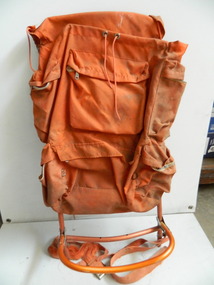
 Kiewa Valley Historical Society
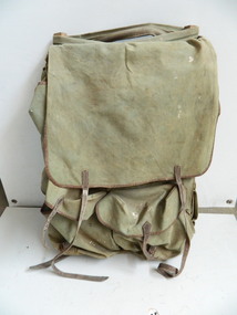
Backpack
This pack is made from materials available at the time and was used to carry supplies and equipment for bushwalking and/or cross country skiing. It is designed to protect the contents in all weather and to be as comfortable and practical as possible. The Bogong High Plains was a popular destination for bushwalking and cross country skiing. This backpack is an early example of the equipment used for extended walks and/or cross country skiing. Heavy green canvas back pack with flap at top to cover contents and to attach at base. Sides fold over at the top. The back is attached with zig zag cord with 5 holes down each side. The front piece has 2 pockets with straps to secure them. The sides have a wooden rectangular piece wrapped by canvas to maintain the shape of the pack. There are webbed shoulder straps on an angle attached to the back with adjustable straps. There is a thin metal rod on the outside of each side presumably to enable items to be hung from them. On the inside of the flap: Leon Henry/Trendweth(?)/ West Brunswick/Melbourne/ Victoria/ Australia Previous name and address has been crossed out.backpack; bogong high plains; bushwalking; cross country skiing -
 Kiewa Valley Historical Society
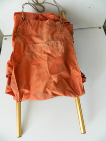
Backpack
This pack is made from materials available at the time and was used to carry supplies and equipment for bushwalking and/or cross country skiing. It is designed to protect the contents in all weather and to be as comfortable and practical as possible.The Bogong High Plains was a popular destination for bushwalking and cross country skiing. This backpack is an example of the equipment used for extended walks and/or cross country skiing.Orange nylon backpack with long flap at the top. This flap has a pocket inserted at the end and 2 holes at each side to tie the rope to the base of the pack. It has 5 zippered pockets each with a flap - 2 on each side top and bottom and 1 large one across the back. The frame is aluminium with a rod each side and 3 slightly curved rods joined to them horizontally and 2 curved thin vertical rods. There are 2 strips of wide canvas at the back. These are held by an adjustable white cord to increase comfort and for a better fit.backpack; bogong high plains; bushwalking; cross country skiing; -
 Kiewa Valley Historical Society
Backpack
This pack is made from materials available at the time and was used to carry supplies & equipment for bushwalking and/or skiing. it is designed to protect the contents in all weather and to be as comfortable and practical as possible.The Bogong High Plains was a popular destination for bushwalking and cross country skiing. This backpack is an example of the equipment used for extended walks and/or cross country skiing.Orange backpack with nylon front and canvas back. The back flap has cord threaded along the sides for adjusting the shape of the pack. It has 6 pockets with zips - 2 each side and 2 across the back. There is 1 pocket with a velcro fastening on the outside of the flap. The cord enables the closing of the top. The frame is aluminium with 2 nearly straight sides and continuing across the top. There are 3 separate aluminium rods that are joined across and 1 piece of canvas.backpack; bush walking; bogong high plains; cross country skiing -
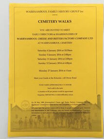 Warrnambool and District Historical Society Inc.
Document - Warrnambool Cemetery Walk 2014, 2014
The Warrnambool Family History Group, founded in 1980, conducts walks in the Warrnambool Cemetery each year. In 2014 the graves visited were those of people who were early directors and share holders of the Warrnambool Cheese and Butter Factory Company Limited. This company was established in 1888 and today is the oldest operating dairy factory in Australia. This item is of minor interest as a memento of an annual activity of the Warrnambool Family History Group.A yellow sheet of paper with black text and an image of an old photograph at the bottom of the sheet.WARRNAMBOOL FAMILY HISTORY GROUP INC. CEMETERY WALKS warrnambool family history group, warrnambool cemetery -
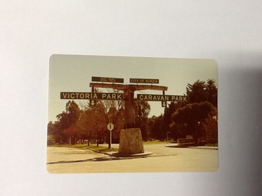 Port of Echuca
Colour Photograph, Approx.1979
In 1869 the Council moved to name this park "Victoria Park. The cricket pitch construction began in 1873 and major improvements to the ground were undertaken in 1881. It is still the primary sporting ground in Echuca, offering AFL football oval, cricket pitch and nets, athletics and entry to the Echuca boat ramp and the natural bush land of the scenic drive. It also houses Echuca Council caravan park. The signage in this photograph is no longer there and the enterance to the caravan park has moved.This area of Echuca has historically been a major recreational area for the town. Being the primary sporting ground since its establishment in 1869., the area has a number of sporting and recreational facilities for the people of Campaspe Shire, from natural bush walks in and along the Murray river to more formal facilities such as AFL football ground, firefighting training area, netball courts, cricket pitch and nets, and grass tennis courts. Colour photograph (post-card size) of directory signs to entrance of Victoria Park, Echuca taken facing north. Two driveways are shown, to the east "Caravan Park" and to the west , "Victoria Park", "Boat ramp", " Scenic drive"Printed in black on the reverse:"this paper manufactured by Kodak"echuca, port of, echuca council caravan park, victoria park, echuca, echuca-tourist attraction -
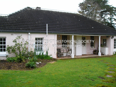
 Eltham District Historical Society Inc
Photograph, Fay Bridge, Rosehill Homestead, EDHS Heritage Excursion, 6 July 2019
July Excursion July 6, 2019 - Exploring Lower Plenty The predominant feature of this walk in the Bonds Road area, Lower Plenty is the large number of magnificent old River Red Gums that line the route. These trees are of the spreading woodland form of this species indicating that they must have been originally growing in a reasonably open setting. The walk also includes parts of the historic Cleveland Estate and the homestead “Rosehill” established by pioneer farmer Henry Stooke. This area was the site of the first recorded European settlement in what was to become the Shire of Eltham when the Willis brothers arrived in the late 1830s. From the southern part of Cleveland Avenue there are extensive views across and along the Yarra Valley. An article on the history of this area was contained in Newsletter edition 201, November 2011. The walk will start at the at the corner of Bonds and Stawell Roads, Lower Plenty - EDHS Newsletter No. 246 June 2019fay bridge collection, 2019-07-06, blackburn bricks, eltham district historical society, heritage excursion, rosehill homestead, lower plenty -
 Eltham District Historical Society Inc
Photograph, Fay Bridge, EDHS Heritage Excursion, Culla Hill, Sweeneys Lane, Eltham, 7 September 2019
September Excursion - Culla Hill Walk Pioneer Eltham farmer Thomas Sweeney (1803 - 1867) named his house, “Culla Hill” after the area in Ireland that he came from. His house, now called “Sweeneys”, remains on a ridge line overlooking the Yarra River. It is recorded that Thomas Sweeney did well out of carting potatoes and other supplies to the various gold fields such as Bendigo, McIvor (Heathcote), Mount Alexander and Beechworth. Culla Hill is now the name of the road providing access to subdivided lots of the former Sweeney property. The Culla Hill walk will start at the corner of Kent Hughes and Lavender Park Roads, Eltham (Melway ref. 22 A9) at 2.00pm on Saturday 7th September. - EDHS Newsletter No. 247 August 20192019-09-07, activities, culla hill, eltham, eltham district historical society, fay bridge collection, heritage excursion, sweeneys lane -
 Eltham District Historical Society Inc
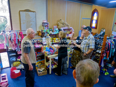
Photograph, Jim Connor, Opportunity Shop, Eltham - Montmorency Uniting Church Hall, 810 Main Rd, Eltham, 7 May 2016
The Society conducted a heritage excursion "Eltham War Memorials Walk" on Saturday, May 7, 2016 in conjunction with the centenary commemorations of the First World War. This walk involved visiting a number of memorials along Main Road dedicated to locals who served Australia in times of war including the Roll of Honour located in the Uniting Church Hall which also serves as the Opportunity Shop, which had once operated out of the former CBA bank building next door.activities, eltham district historical society, heritage excursion, jim connor collection, opportunity shop, uniting church, uniting church hall, 2016-05-07 -
 Eltham District Historical Society Inc
Photograph, Fay Bridge, EDHS Heritage Walk: Shillinglaw Farm, Eltham, 2 September 2023
On Saturday September 2, 2023, Russell Yeoman led a group of 22 society members and interested others on a walk following trhe bounadries of the original Shillingalw farm. Commencing at the corner of Panther Place and Library Place, we proceeded up to Shillinglaw Cafe then the Shillinglaw trees at the former Eltham Shire Office site then along Main Road to the fire station then throughh St Laurence Lane and uinder the railway line , along Diamond Street then return via the Diamond Creek trail behind Andrew Park. The actual farm boundary went past the creek and further up the hill. The original farm comprised lot 90 of Holloway’s 1851 subdivision of Little Eltham. Its area was 30 acres lying east of the Diamond Creek and north of Henry Street. A number of stops were made to look at maps and early photos illustrating the gradual reduction of the farm area and the early history of the railway and other community uses, that occupied parts of the site.fay bridge collection, 2023-09-02, activities, eltham, eltham district historical society, heritage excursion, shillinglaw farm -
 Eltham District Historical Society Inc
Photograph, Liz Pidgeon, EDHS Heritage Walk: Shillinglaw Farm, Eltham, 2 September 2023
On Saturday September 2, 2023, Russell Yeoman led a group of 22 society members and interested others on a walk following trhe bounadries of the original Shillingalw farm. Commencing at the corner of Panther Place and Library Place, we proceeded up to Shillinglaw Cafe then the Shillinglaw trees at the former Eltham Shire Office site then along Main Road to the fire station then throughh St Laurence Lane and uinder the railway line , along Diamond Street then return via the Diamond Creek trail behind Andrew Park. The actual farm boundary went past the creek and further up the hill. The original farm comprised lot 90 of Holloway’s 1851 subdivision of Little Eltham. Its area was 30 acres lying east of the Diamond Creek and north of Henry Street. A number of stops were made to look at maps and early photos illustrating the gradual reduction of the farm area and the early history of the railway and other community uses, that occupied parts of the site.2023-09-02, activities, eltham, eltham district historical society, heritage excursion, shillinglaw farm, 895 main road, amplifon, andrew park, andrew pocket park, arthur street, bar de tapas, barber shop, barry plant estate agent, blockbuster, bus depot, car park, carparks, central park, cleaver & co hair, commonwealth bank, crust pizza, divine bridal, dr ash constance, dudley street, eltham book shop, eltham convenience store, eltham fire station, eltham library, eltham newsagency, eltham optical, eltham railway station, eltham shops, fay bridge, fire bell, flagpole, flight centre, grill'd, information sign, iso chook, jellis craig estate agent, judge book village, kebab nation, kx pilates, la zanyas, liquorland, little drop of poison, lorraine jones & associates solicitors, luck street, machan indian restaurant, main road, mecho en mexico, missing gorilla, morrison kleeman real estate, pavilion menswear, platform 3095, playtherapy melbourne, pryor street, ray white real estate, restaurants, sage bulk whole foods, shillinglaw trees, sign, snap fitness, southern cross medical imaging, specsavers, st laurence lane, st vincents care service, thompson's pharmacy, todaro, united service station, vyve body & skin, welcome to eltham town, westpac bank, yang's kitchen, youth road -
 Eltham District Historical Society Inc
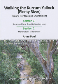
Book, Anne Paul, Walking the Kurrum Yallock (Plenty River), 25 July 2023
Kurrum Yallock - the Plenty River is Melbourne's third river. It is a defining feature of the region weaving its way through local suburbs and parklands. It is often hidden from general view, emerging at bridges and along its extensive trail network. While diminished since European settlement, the River provides an important environmental, wildlife corridor and recreational resource, along with many links to its settlement heritage. The Kurrum Yallock walks aim to guide people along the River Trail, while providing insight into key aspects of our recent history, an opportunity for reflection and an enhanced enjoyment of the River's special environment and landscape.birrarung, greensborough historical society, kurrum yallock, martins lane, plenty river, yallambie, yarra river -
 Eltham District Historical Society Inc
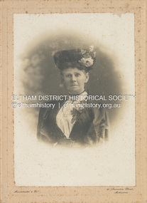
Photograph - Panel Photograph, F.B. Mendelssohn & Co, Possibly Jane Key, c.1896
Jane Key (nee Dalrymple 1846-1931) married Frederick Key (1844-1907). Their daughter Ada Key married baker, John Ingram. Mendelssohn Photographers, 80 Swanston St., Melnourne F.B. Mendelssohn & Co operated from Queen's Walk Studios, Victoria Buildings at 80 Swantson Street, Melbourne from 1888-1915 according to Sands McDougall directoriesF.B. Mendelssohn & Co operated from Queen's Walk Studios, Victoria Buildings at 80 Swantson Street, Melbourne from 1888-1915 according to Sands McDougall directoriesInscribed on back "? Jane Key" and "My Great Grandmother" and "Pam Thoonen"jane key (nee dalrymple 1846-1931), mendelssohn f.b. & co photographer 80 swanston st melbourne, pam thoonen (nee ingram) collection