Showing 9408 items matching "hobsons-bay"
-
 Stawell Historical Society Inc
Book - History, Shipping Arrivals and Departures Vol 2 1846-1855
Dust Jacke Hardback: Blue background, white Print, Colour Print "View of Hobson's Bay by Captain Thomas RobertsonA Roebuck Book Shipping Arrivals and Departures Victorian Ports {Colour Print of Hobsons Bay} Volume 2 1846 - 1855 Marten A. Syme -
 Lakes Entrance Historical Society
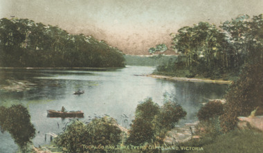
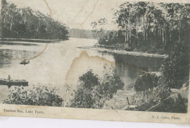
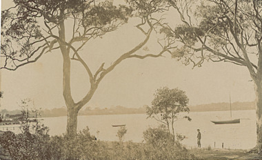
Postcard - Lake Tyers, Toorloo Bay Lake Tyers Victoria, 1905c
showing two rowing boats on calm arm of lake surrounded by thick timber Lake Tyers VictoriaTinted postcard of Toorloo Bay Lake Tyers VictoriaToorloo Bay Lake Tyers Gippsland Victoriabusinesses, hotels -
 Ballarat Heritage Services
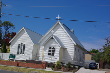
Photograph - Photograph - Colour, Clare Gervasoni, St Aiden's Anglican Church, Apollo Bay, 2013, 27/01/2013
Colour photograph of weatherboard church at Apollo Bay. Gothic in style it is typical of the simple timber churches built by less wealthy communities in Victoria, mostly before the First World War. St Aiden's was built and opened in 1905, with a local resident as builder. .St Aidan's is one of only a few buildings in Apollo Bay remaining from before World War I. apollo bay, st aiden's anglican church -
 St Kilda Historical Society
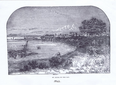
Photograph - Lithograph, St Kilda on the Bay, 1862
St Kilda Beach and piers, Christ Church on the hillblack and white lithograph, unmounted, copy, fair conditionSt Kilda on the Bay. 1862 Copy courtesy LaTrobe Library, Melbourne, from: The illustrated Melbourne Post, January 1862, p12. -
 Mission to Seafarers Victoria
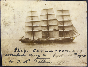
Photograph, George Schutze, Ship Carnarvon Bay wrecked King Island 15 September 1910 - R.J.N Filkin apprentice, c. 1910
The ship Carnarvon Bay bound from Liverpool to Sydney with a general cargo struck rocks off Stokes Point on the coast of King Island on Thursday 15 September 1910. On the day the crew used two lifeboats but were separated. One of them with Captain W. Griffith and 17 men was rescued by the SS Taracoola and brought back to Melbourne. Apprentice, R.J.N Filkin was amongst them (his name is listed on the Argus article relating the event (Monday 19 September 1910). In the article called "Welcome Shelter" it seems it was the first sea voyage for the young Filkin. The other boat with 15 men was lost for several hours. There was no casualties but the 3000 ton cargo was lost. The seamen were received at the Sailors Home then welcomed at the Mission by Reverend Haire as shown on a photograph publish in the Punch (22 September 1910). Reverend Gurney Goldsmith was in England at the time. The crew was invited to an evening of entertainment organised by artist Violet Teague at the Masonic Hall on the 19th of September. According to the article "Welcome Shelter" she was painting the "tableaux" at the Mission when the seamen were present, interviewed by the journalist. This evening organised by the Ladies Harbour Lights Guild was planned to raise funds for the Mission.Sepia photograph depicting the ship Carnarvon Bay at sea with a written inscription in black ink.Ship Carnarvon Bay wrecked King Island 15 September 1910 - R.J.N Filkin apprenticeshipwreck, apprentice, king island, carnarvon bay, captain griffith, violet teague, masonic hall, ss taracoola, crews and ships -
 Phillip Island and District Historical Society Inc.
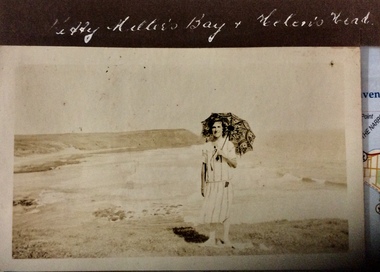
Photograph, Kitty Miller Bay and Helen’s Head, 1925-1926
Sepia photograph of a woman with a parasol, standing on a grassy area above a wide bay with a headland in the distance.Kitty Millers Bay and Helen’s Headphotographs, kitty miller bay phillip island, helen’s head, phillip island -
 Victorian Interpretive Projects Inc.
Photograph-Colour, Wild Dog Creek, Apollo Bay, 2015, 25/01/2015
Wild Dog Creek enters the sea at Apollo BayA number of colour photographs showing the mouth of Wild Dog Creek as it enters the sea at Apollo Bal, Victoria.apollo bay, sea, creek, river mouth, wold dog creek -
 Lakes Entrance Historical Society
Photograph - Toorloo Bay Lake Tyers Victoria
Advertisement on back for Sale Steamboat Co LtdBlack and white photograph showing heavily forested shorelines, two small rowing boats left foreground Toorloo Bay Lake Tyers VictoriaToorloo Bay Lake Tyerswaterways, topography, gippsland lakes -
 Lara RSL Sub Branch
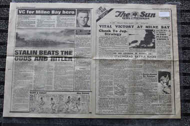
Newspaper - The Sun Newspaper Dated 1/9/1942 - Special - My War Part 30 - Vital Victory At Milne Bay - Victory at Milne Bay, Local Newspaper Dated 1/9/1942 - Special - My War Part 30 - Vital Victory At Milne Bay - Victory at Milne Bay
Local Newspaper dated 1/9/1942 reporting on World War 2 Events - Victory At Milne Bay - Stalin Beat The Odds and HitlerVictory At Milne Bay - Stalin Beat The Odds and HitlerLocal Newspaper dated 1/9/1942 reporting on World War 2 - Special _ My War Part 30 Victory At Milne Bay - Stalin Beat The Odds and Hitlerworld war 2, my war 2, local newspaper dated 1/9/1942 -
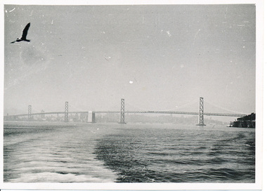 Mission to Seafarers Victoria
Photograph - Photograph, Black and white, Allan Charles Quinn, The Bay Bridge, 12 November 1949
This photograph is part of series depicting Allan Quinn's travels through San Francisco in 1949. This photograph is a landscape shot of the San Fransisco Oakland Bay Bridge.This is a photograph from the Allan Charles Quinn collection which is a collection of letters and photograph depicting aspects of life at sea for a young man in the era immediately following World War II.A black and white photograph of the San Francisco Bay and the Oakland Bay Bridge.Reverse: 12-11-49 handwritten in blue ink. Below this are some indecipherable marks in pencil.allan-quinn, photograph, san-francisco, bay-bridge, 1949, merchant navy -
Glenelg Shire Council Cultural Collection
Slide - Slide - Henty Beach, Portland, PORTLAND BAY, 1960s
Taken by Mr. P.G.W. (Wal) Whitelam in the early to mid 1960'sAlfacolor Slide of Henty Beach, Portland Bay. Paddle Boats on sand on left. Left side cars in carpark. Moored boats & Railway Pier in background.Front: Portland Bay Vi , blue birophotography, slide, 1960s, henty beach, railway pier, portland -
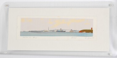 Glenelg Shire Council Cultural Collection
Print, Portland Bay, 1983
CEMA Art Collection Part of "A Community View" 150 years in Portland Screenprint Exhibition Part of Angela Gee Residency 1983 and 1984Laminated screenprint of Portland Bay. Wide angle view of the Bay, with water tower / lighthouse on the right, the harbour with a docked ship in the centre, and the end of the peninsular and ocean on the left.Front: "Portland Bay" (lower left) Proof (lower right centre) A Gee '83 (lower right) (pencil) Back: 12 -
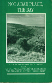 Otway Districts Historical Society
Book, Not a bad place, the Bay, 1987
An Apollo Bay oral history project converted into a written work, it covers the lives of ten older residents and their times in Apollo Bay.Not a bad place, the Bay. Old residents of Apollo Bay talk to local primary school children and members of the community. Jackie Price (ed.). Nadia Wheatley (ed.) Apollo Bay (Vic); The Killala Road Publishing Co.; 1987. 160 p.; illus, map. Hard cover. ISBN 0 9587872 0 4not a bad place, the bay; apollo bay; jackie price (ed.); nadia wheatley (ed.); interviews; social life and customs; history; -
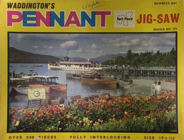 Kew Historical Society Inc
Leisure object, Waddingtons, Bowness Bay, Design No.753 : Waddington's Pennant Vari-Piece Jig-Saw, c.1965
Waddingtons is a famous card and board manufacturer. It commenced business in 1927 and produced jig-saw puzzles from the mid 1930s. Their Christmas, Map, and circular jig-saw series were their most popular jig-saws. Various-piece jig-saws were introduced c.1965 and were very popular in the 1960s and 1970s.Jig-Saw puzzle in original box depicting Bowness Bay on cover. Bowness Bay is in the Lake District, Cumbria (UK). The puzzle has 340 pieces.Exterior of Box: " Waddington's Pennant Jig-Saw. Over 340 pieces, fully interlocking, Size 19" x 11 3/8. / Design No. 753 Bowness Bay"jig-saw puzzle, waddingtons, bowness bay - cumbria --- uk -
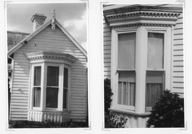 Stawell Historical Society Inc
Photograph, Bay Window examples of the Federation House Period -- 2 Photos
Photographs taken to show examples of the detail of a Bay Window in the Federation Period. One photo showing the bay window and weather board surrounding the window. The second photo a detail of the window.Two black & white photographs showing details of the front of a weather board building with a bay window.stawell residence homes -
Lakes Entrance Historical Society
Book, Angus and Robertson Pulbishers, Killers of Eden - The Killer Whales of Twofold Bay, 1961
This book tells of the Davidsons and the killer whales of Twofold BaySmall paperback 222 pages. A true story providing history of whaling at Twofold Baywhaling industry, maritime history, people -
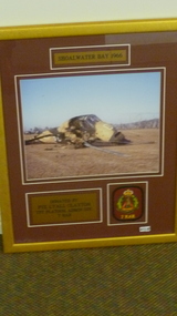 National Vietnam Veterans Museum (NVVM)
Photograph, SHOALWATER BAY 1966, 1966
Colour Photo in Gold Frame. Burgandy Mat crashed Wessex Helicopter- Shoalwater Bay 1966 7 RAR Badge/ British Marine helicpoter.SHOALWATER BAY 1966. Donated by PTE LYALL CLAYTON,TPT PLATOON,ADMIN coy.7 RAR.7 rar, wessex (helicopter) -
Glenelg Shire Council Cultural Collection
Photograph, View across North Portland to Bridgewater Bay, 1968
Port of Portland Authority archives.Front: (no inscriptions) Back: LOOKING ACROSS NORTH PORTLAND TOWARDS BRIDGEWATER BAY JULY. 1968port of portland, bridgewater bay, wool stores -
Port Melbourne Historical & Preservation Society
Document, Jan HARPER, Sugar and Starch to Sandridge Bay Towers, 2023
Jan HARPER's document covers the history of the building from the Victorian Sugar Works to Harper's Starch Factory to Sandridge Bay Towers.White oblong 26 page publication with colour photograph of Sandridge Bay Towers on the cover.sandridge bay towers, harpers starch factory, victorian sugar works -
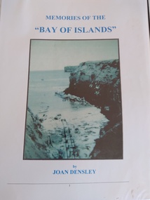 Peterborough History Group
Book, Memories of the Bay of Islands + Crofts Bay Huts
Early use of Crown Land for holiday makers prior to the Great Ocean Road extension, when leaseholders were forced to relinquish their land and houses. Includes a list of the names of occupants at that time. Also includes letters from the Crown Lands Dept about the efforts to retain the Crofts Bay Huts.Significant because it is an eyewitness description of the huts which were demolished in the mid 1970's. Also describes holiday activities and mentions other families in the area.Folder containing the photocopy of the book by Joan Densley and the separate story of the Crofts Bay huts.including copies of Crown Land documents and letters. Includes copy of photographs of the huts and beach.peterborough, crofts bay, bay of islands, joan densley, great ocean road, crofts bay huts, bay of islands huts -
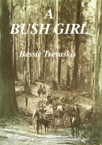 Otway Districts Historical Society
Book, Apollo Bay & District Historical Society Inc, A Bush Girl, December 2001
A family history about the Holmes family and one daughter's marriage to Mark Trevaskis between 1897 and 1912.A Bush Girl. A story about life in the Otway ranges between 1897 and 1912. Eveline Bessie Orlina Trevaskis. Apollo Bay; Apollo Bay & District Historical Society; 2001. vi, 64 p.; illus, maps. Soft cover. ISBN 0 9577956 2 9a bush girl; bessie trevaskis; otway ranges; family history; barramunga; wongarra; -
 Lakes Entrance Historical Society
Postcard, Bancroft Bay Metung Victoria, 1900 c
Two small boats moored in bay person standing on shoreSepia toned postcard taken from waterfront looking across Bancroft Bay towards Boole Poole Metung Victoria boats and boating, jetties, waterways -
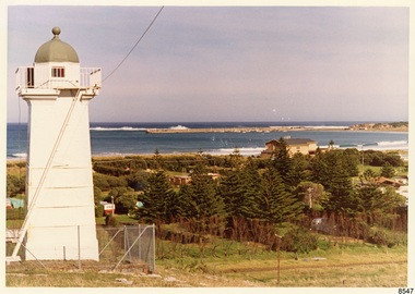 Flagstaff Hill Maritime Museum and Village
Photograph - Historical, Flagstaff Hill, John Lindsay, View of the Bay from the south boundary of the Ports and Harbours land, 1970s
The photograph shows the view of the shore and Lady Bay with the Breakwater and Middle Island all visible. It was taken to show that the Flagstaff Hill area was unlikely to have any further development between it and the Bay, with the view of development of the Flagstaff Hill Maritime Museum and Village. This photograph, a print, is one of a set of five that show the site of Flagstaff Hill. The photographer was John Lindsay, Founding Director of Flagstaff Hill Maritime Museum and Village, with the words "Photo J Lindsay" on the back. It was taken in the early 1970s during the initial stages of the development of Flagstaff Hill as a Museum and Maritime Village. The photographs belonged to the donor's grandparents, who lived in the Warrnambool district of Allansford/Naringal. The photograph is a record of the site and surrounds of Flagstaff Hill Maritime Museum and Village before its development and opening in 1975. It shows the Surfside Holiday Park, Surf Lifesaving Club, and the Breakwater. The photograph is significant for recording the location and condition of the Lower Lighthouse on the Hill.Coloured photograph, glassy print, one of a set of five. Flagstaff Hill's Lower Lighthouse is in the foreground above the Surfside Holiday Park. To the right of centre is the Surf Lifesaving Club. In the background is Lady Bay and the Breakwater and Middle Island, with the Southern Ocean the other side. The photograph's paper has the printer's watermark and a pencilled inscription on the back. The early 1970s scene was photographed by John Lindsay, Warrnambool.Label on the back: "VIEW OF THE BAY FROM the southern boundary of the Ports and Harbours land. No development below this area is likely to obstruct the view, due to the steep grade down to the Southern boundary of Flagstaff Hill property." Handwritten in pencil: "Photo J Lindsay"flagstaff hill, flagstaff hill maritime museum and village, warrnambool, maritime museum, maritime village, great ocean road, shipwreck coast, 1970s, photograph, surfside holiday park, lady bay, flagstaff hill site, john lindsay, lower lighthouse, lower light, surf lifesaving club, breakwater, middle island, ports and harbours -
 Victorian Interpretive Projects Inc.
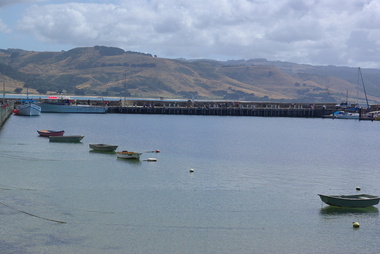
Photograph - Colour, Clare Gervasoni, Apollo Bay Marina, 2013, 27/01/2013
The image show the number and typs of boats moored at Apollo Bay Marina in late January 2013.Two colour photgraphs showing the marina at Apollo Bay from the pier. .1) a number of anchored boats .2) a number of fishing vessells at the marina. apollo bay, boat, vessel, fishing -
![Mount St. George, Addis Bay / [by] Nicholas Caire, circa 1876](/media/collectors/550653872162f11fb04854aa/items/57833f9fd0cdd1176c6828f5/item-media/57833ffdd0cdd1176c685980/item-fit-380x285.jpg) Kew Historical Society Inc
Kew Historical Society IncPhotograph, Anglo-Australasian Photographic Company, Mount St. George, Addis Bay, c. 1876
Nicholas Caire was born on Guernsey in the Channel Islands in 1837. He arrived in Adelaide with his parents in about 1860. In 1867, following photographic journeys in Gippsland, he opened a studio in Adelaide. From 1870 to 1876 he lived and worked in Talbot in Central Victoria. In 1876 he purchased T. F. Chuck's studios in the Royal Arcade Melbourne. In 1885, following the introduction of dry plate photography, he began a series of landscape series, which were commercially successful. As a photographer, he travelled extensively through Victoria, photographing places few of his contemporaries had previously seen. He died in 1918. Reference: Jack Cato, 'Caire, Nicholas John (1837–1918)', Australian Dictionary of Biography.An original, rare photograph from the series 'Views of Victoria: General Series' by the photographer, Nicholas Caire (1837-1918). The 60 photographs that comprise the series were issued c. 1876 and reinforced a neo-Romantic view of the Australian landscape to which a growing nationalist movement would respond. Nicholas Caire was active as a photographer in Australia from 1858 until his death in 1918. His vision of the Australian bush and pioneer life had a counterpart in the works of Henry Lawson and other nationalist poets, authors and painters.‘Mount St. George, Addis Bay’ : Views of Victoria (General Series) No.56 : Albumen silver photograph | Photo on card with Title and Description on reverse | Mounted 24 x 30 cm; Photo 12 x 17 cm.On Reverse: ‘Addis Bay is situated to the north-east of Appollo Bay, and very near Cape Patten. This mountain is 6,000 feet high, and commands one of the finest views on the Cape Otway Ranges. The ascent is a somewhat difficult one, but visitors to this locality not unfrequently make this a favourite outing.’nicholas caire (1837-1918), landscape photography -
 Flagstaff Hill Maritime Museum and Village
Document - Navigation Chart, Admiralty Office, Lady Bay and Warrnambool Harbour, 03/04/1871
This Chart titled “Lady Bay and Warrnambool Harbour” was surveyed by Nav. Lieut. H.J. Stanley, of Britain's Royal Navy, in 1870 and printed in April 1871. The chart was made before the Warrnambool Breakwater was built (construction had begun in 1874 and was completed in 1890). The chart includes Directions for entering Lady Bay, Warrnambool Harbour. These are "Vessels entering Warrnambool Harbour must bring the Red Light in sight and steer in with it in line with the upper white Light bearing North, until the Green Light on the Jetty is opened, when steer towards it and anchor. The best anchorage is in 2 ¼ fms [fathoms)] of water, about a cable from ledge off Breakwater rock. Or where convenient, according to draught of water, only endeavouring to anchor as close as possible to Breakwater rock. It is not safe to enter or leave the Harbour in south westerly or Southerly gales.” This chart is significant for its strong connection to the maritime history of Warrnambool Harbour and Lady Bay, and eventually to the Warrnambool Breakwater. The Warrnambool Breakwater is registered as a place of significance on the Victorian Heritage Database (VHR H2024). A copy of the same chart was used to plan several submissions for future changes to the jetty and breakwater. The chart is a historical record of structures existing in 1870; the Warrnambool Jetties, Lady Bay, the leading lights (lighthouses), streets, roads, bridges and many buildings. It also shows the lay of the land and seabed.Canvas chart of Australia, South Coast, Victoria Title: Lady Bay and Warrnambool Harbour Surveyed by Nav. Lieut. H.J. Stanley, R.N., 1870. Magnet Variation, 1870 Published April 3, 1871, by the Admiralty, London. Directions for vessels entering Warrnambool Harbour are printed on the chart. The chart has a lacquer or seal over it.Top of chart has logo "HYDROGRAPHER OFFICE" "Price Eighteen Pence". "Engraved by Edward Weller" Along bottom of Chart: “London… Published at the Admiralty, 3rd April 1871, under the Superintendence of Rear Admiral G.H. Richards, F.R.S. Hydrographer, Corrections July 71” Bottom of chart “Australia South Coast Victoria Lady Bay and Warrnambool Harbour. 2494”flagstaff hill, warrnambool, chart of lady bay warrnambool 1870, warrnambool harbour, cartography, navigation, warrnambool breakwater, 1871, australia – south coast / victoria, lady bay, 1870, nav. lieut. h.j. stanley, r.n, directions for entering warrnambool harbour, hydrographer office, rear admiral g.h. richards, edward weller, port of warrnambool, flagstaff hill maritime museum & village, maritime museum, maritime village, shipwreck coast, map, chart, navigation chart, admiralty chart, breakwater, jetty, pier, vhr h2024 -
Port Melbourne Historical & Preservation Society
Photograph, "Melbourne & Hobson's Bay United Railway Co'ys Pier, Sandridge (Port Melbourne) 1865", 1865
City of Port Phillip Collection - pm 0988 "Melbourne & Hobson's Bay United Railway Co'ys Pier, Sandridge (Port Melbourne) 1865" . View looking South showing tall masted ships and in the foreground, workmen, carriages loaded with ballast and a boiler for steam powered cranes. Image attributed to Charles Nettleton transport - shipping, piers and wharves - railway pier, maritime, railway pier, charles nettleton, hobson's bay united railway -
 Greensborough Historical Society
Book, Virtuosity: inside the heads of 100 prominent Australians, 1997_
... New Hobsons Press ...100 prominent Australian were asked why they have achieved so much - is it talent or determination?Paperback book, 143 pages, black and white photographs and line drawings.australia social conditions -
 Ballarat Heritage Services
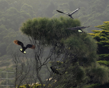
Digital photographs, L.J. Gervasoni, yellow tail black cockatoo apollo bay, c2015
Digital images of some yellow tailed black cockatoos.yellow tail black cockatoo, cockatoo, black cockatoo, birds, apollo bay -
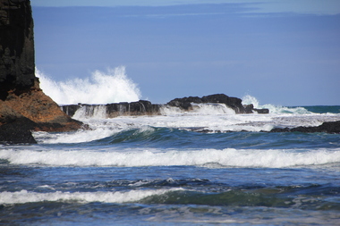 Ballarat Heritage Services
Digital photographs, L.J. Gervasoni, Bushrangers Bay, 2016
coast, coastal, coastal geomorphology, geology, ocean, waves, bushrangers bay