Showing 62 items matching "instrument used for navigation"
-
 Flagstaff Hill Maritime Museum and Village
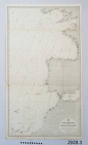
Document - Navigation Chart, Portsmouth to Canary Islands, Ca. 1928
... are used in conjunction with other navigational instruments... are used in conjunction with other navigational instruments ...This is an Official British Admiralty Navigation Chart, one of a set of 65 charts donated together with a wooden chart case. It was published and printed in London in 1928 by the British Admiralty. Navigation charts are drawn by professional hydrographers and describe the geography of land and water, enabling a water based navigator on board vessels such as ships to safely negotiate between ports locally and around the world. They are drawn to a particular standard with common symbols noting landmarks. The charts are used in conjunction with other navigational instruments and tools to calculate the vessel’s exact location and a safe route to its destination.The set of charts and their chart are of significance as examples of equipment and documents used to navigate the oceans of the world, particularly to Australia. Migration to Australia is an important part of this country's history.British Admiralty Navigation Chart - Portsmouth to Canary Islands - printed on rectangular white paper. Published in London by the British Admiralty in 1928.warrnambool, shipwreck coast, flagstaff hill, flagstaff hill maritime museum, flagstaff hill maritime village, chart, map, navigate, navigation, location, vessel, 1928, british admiralty, hydrographer, geography, admiralty chart, portsmouth, canary islands -
 Flagstaff Hill Maritime Museum and Village
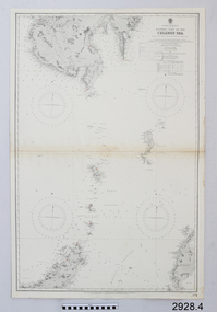
Document - Navigation Chart, Eastern Part of the Celebes Sea, Ca. 1928
... are used in conjunction with other navigational instruments... are used in conjunction with other navigational instruments ...This is an Official British Admiralty Navigation Chart, one of a set of 65 charts donated together with a wooden chart case. It was published and printed in London in 1928 by the British Admiralty. Navigation charts are drawn by professional hydrographers and describe the geography of land and water, enabling a water based navigator on board vessels such as ships to safely negotiate between ports locally and around the world. They are drawn to a particular standard with common symbols noting landmarks. The charts are used in conjunction with other navigational instruments and tools to calculate the vessel’s exact location and a safe route to its destination.The set of charts and their chart are of significance as examples of equipment and documents used to navigate the oceans of the world, particularly to Australia. Migration to Australia is an important part of this country's history.British Admiralty Navigation Chart - Eastern Part of the Celebes Sea - printed on rectangular white paper. Published in London by the British Admiralty in 1928.warrnambool, shipwreck coast, flagstaff hill, flagstaff hill maritime museum, flagstaff hill maritime village, chart, map, navigate, navigation, location, vessel, 1928, british admiralty, hydrographer, geography, admiralty chart, celebes sea -
 Montmorency–Eltham RSL Sub Branch
Equipment - Navigational Computer
Rectangular calculating instrument with (1) 'hinged lid' fitted with circular rotating dial for setting/reading altitude, speed, distance and temperature, (2) notebook inside lid, (3) circular dial with perspex cover, beneath which is (4) graph chart, moveable up-and-down by means of rotating knob on side of device. Curved brackets and elasticized straps on back for strapping onto pilot's leg.R.A.A.F. Ident. No. G6B/145 Serial No. WG/2233 COMPUTER NAVIGATIONAL Mk. III D. (Other inscriptions including instructions for use and scales for various measurements) "AB" hand written on strap (owner's initials?) -
 Flagstaff Hill Maritime Museum and Village
Octant, Mid to late 19th Century
An octant is an astronomical instrument used in measuring the angles of heavenly bodies such as the sun, moon and stars at sea in relation to the horizon. This measurement could then be used to calculate the altitude of the body measured, and then the latitude at sea could also be calculated. The angle of the arms of an octant is 45 degrees, or 1/8 of a circle, which gives the instrument its name. Two men independently developed the octant around 1730: John Hadley (1682–1744), an English mathematician, and Thomas Godfrey (1704–1749), a glazier in Philadelphia. While both have a legitimate and equal claim to the invention, Hadley generally gets the greater share of the credit. This reflects the central role that London and the Royal Society played in the history of scientific instruments in the eighteenth and nineteenth century's. There were also two others who are attributed to having created octanes during this period, Caleb Smith, an English insurance broker with a strong interest in astronomy (in 1734), and Jean-Paul Fouchy, a mathematics professor and astronomer in France (in 1732) In 1767 the first edition of the Nautical Almanac tabulated lunar distances, enabling navigators to find the current time from the angle between the sun and the moon. This angle is sometimes larger than 90°, and thus not possible to measure with an octant. For that reason, Admiral John Campbell, who conducted shipboard experiments with the lunar distance method, suggested a larger instrument and the sextant was developed. From that time onward, the sextant was the instrument that experienced significant development and improvements and was the instrument of choice for naval navigators. The octant continued to be produced well into the 19th century, though it was generally a less accurate and less expensive instrument. The lower price of the octant, including versions without a telescope, made it a practical instrument for ships in the merchant and fishing fleets. One common practice among navigators up to the late nineteenth century was to use both a sextant and an octant. The sextant was used with great care and only for lunar sightings while the octant was used for routine meridional altitude measurements of the sun every day. This protected the very accurate and pricier sextant while using the more affordable octant for general use where it performs well. The invention of the octant was a significant step in providing accuracy of a sailors latitude position at sea and his vessels distance from land when taking sightings of land-based landmarks.Octant with metal handle, three different colored shades are attached, in wooden wedge-shaped box lined with green felt. Key is attached. Two telescope eyepieces are in box. Some parts are missing. Oval ink stamp inside lid of box, scale is graduated to 45 degrees. Ink stamp inside lid of box "SHIPLOVERS SOCIETY OF VICTORIA. LIBRARY"instrument, flagstaff hill, warrnambool, shipwrecked coast, flagstaff hill maritime museum, maritime museum, shipwreck coast, flagstaff hill maritime village, great ocean road, octant, navigation, nautical instrument, navigation instrument, john hadley, sextant, astronomical instrument -
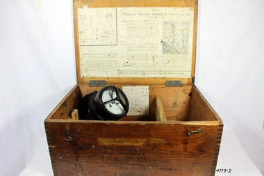
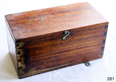 Flagstaff Hill Maritime Museum and Village
Container - Box
... pitch or slope scientific instrument box navigational instrument ...A ship's rudder indicator is used for measuring the angle of slope or pitch of the vessel. The information can be used to adjust the steering of the ship to give safe navigation. The rudder indicator transmitter once contained in this box was battery operated, according to the label inside this box. Box, wooden, used to store a battery operated Siemen's ship's rudder indicator. Made in the United Kingdom. Descriptive leaflet glued inside hinged lid. Lid secured by hooked catch. Brass latch. Metal mounting plate. Hole drilled in back. Dovetail joints. flagstaff hill, warrnambool, shipwrecked-coast, flagstaff-hill, flagstaff-hill-maritime-museum, maritime-museum, shipwreck-coast, flagstaff-hill-maritime-village, siemen's brothers london, siemen's rudder indicator box, nautical instrument for measuring pitch or slope, scientific instrument box, navigational instrument box -
 Flagstaff Hill Maritime Museum and Village
Instrument - Ship Log, Early 20th Century
In times past the only way to measure a ship’s speed was to throw a wood log into the water and observe how fast it moved away from the ship. In the 16th century, the log was fastened to a rope knotted at set intervals. The log was thrown over the stern (back) of the vessel and a crew member counted the number of knots that were paid out in a set time. From this, they could estimate the vessel's speed through the water. This was known as streaming the log and is also the derivation of the knot as a measurement of nautical speed. Various manufacturers of nautical equipment had sought over the years to perfect the operation of determining a ship's speed and it wasn't until Thomas Walker and his son Ferdinand developed a mechanical system that eventually made this task became easy for marine navigators. Thomas Walker & Son were internationally renowned in the manufacturing of ship logs the founding father, Thomas Walker (1805–1871), an engineer in Birmingham, patented his mechanical log in 1878 which was a recording instrument that attached to a rail at the stern of a vessel connected by a long cord with a rotor which was towed behind the ship. The instrument dial then recorded the distance travelled. Thomas Walker first went into business to manufacture stoves at 58 Oxford Street Birmingham. Walker’s self-feeding stove was widely lauded at the Paris Exhibition of 1855, winning a prize medal and kickstarting the first of many notable innovations for the Walker family's manufacturing business. However, it wasn’t until working on an earlier ship’s log model invented by his Uncle that Thomas Walker became interested in the further development of this device, used to ascertain a ship’s speed. Walker continued to improve on the common log for the company of Massey & Sons and these improvements were deemed revolutionary. This log became a firm favourite of the West India Association (a British-based organisation promoting ties and trade with the British Caribbean), being the most common log in use for two generations. It took until 1861 for Thomas Walker and his son, Thomas Ferdinand Walker (1831-1921) to patent the first Walker log of many. Together, with the introduction of the A1 Harpoon Log two years later, they established the Walker Log Business as a force to be reckoned with. By his passing in 1871, Thomas Walker Snr had not only founded a family business with considerable staying power but also instilled a tradition of public service. Having sat as a representative on the Birmingham Town Council for 15 years and played an active role in public works, he was soon given the nickname of ‘Blue Brick Walker’. Much like his father, Thomas Ferdinand Walker changed the face of the maritime industry. His patent of 1897, the ‘Cherub’ log, was a notable departure from the past providing a far more accurate reading and replacing the majority of logs of the age. They were the first to produce an electric log (Trident) and the Walker factory was one of the first to introduce the 48-hour work week for employees.The ship log was invented and made by a significant marine instrument maker and innovator of machinery. It demonstrates the huge leap taken to improve navigational accuracy at sea with an instrument that was in use for decades.Ships Log, Walker Trident electric motor, in wooden box with instructions inside box. The motor dial with electric cord is still inside box.Inscription "Admiralty patent number 3332" and "Walker Trident Electric Ship Log (Mark III), 15-25 volt". On top of lid, hand written, is "G TAYLOR"flagstaff hill, warrnambool, shipwrecked-coast, flagstaff-hill, flagstaff-hill-maritime-museum, maritime-museum, shipwreck-coast, flagstaff-hill-maritime-village, ships log, thomas walker & son, electric ships log, marine navigation, thomas ferdinand walker, ship log -
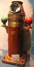 Flagstaff Hill Maritime Museum and Village
Functional object - Binnacle and Magnetic Compass
In 1947, the scientific instrument manufacturing firms of Henry Hughes & Son Ltd, London, England, and Kelvin Bottomley & Baird Ltd, Glasgow, Scotland, came together to form Kelvin & Hughes Ltd. Hughes Company History: Henry Hughes & Sons were founded in 1838 in London as a maker of chronographic and scientific instruments. The firm was incorporated as “Henry Hughes & Sons Ltd” in 1903. In 1923, the company produced its first recording echo sounder and in 1935 a controlling interest in the company was acquired by S Smith & Son Ltd resulting in the development and production of marine and aircraft instruments. Following the London office's destruction in the Blitz of 1941, a collaboration was entered into with Kelvin, Bottomley & Baird Ltd resulting in the establishing “Marine Instruments Ltd”. Following the formal amalgamation of Kelvin, Bottomley & Baird Ltd and Henry Hughes & Sons Ltd in 1947 to form Kelvin & Hughes Ltd. Marine Instruments Ltd then acted as regional agents in the UK for Kelvin & Hughes Ltd who were essentially now a part of Smith's Industries Ltd founded in 1944 and the successors of S. Smith & Son Ltd. Kelvin & Hughes Ltd went on to develop various marine radar and echo sounders supplying the Ministry of Transport, and later the Ministry of Defence. The firm was liquidated in 1966 but the name was continued as Kelvin Hughes, a division of the Smiths Group. In 2002, Kelvin Hughes continues to produce and develop marine instruments for commercial and military use. (See Note section this document for further information on the company's origins) This model binnacle and compass is a good example of the commercial diversity of navigational instruments made by Kelvin & Hughes after world war 2. It was made in numbers for use by shipping after the second world war and is not particularly rare or significant for its type. Also, it was made no earlier than 1947 as the firms of Kelvin, Bottomley & Baird Ltd and Henry Hughes & Sons Ltd who took over from Smith & Sons were not amalgamated until 1947. It can there for be assumed that this item was made during the company's transitional period to Kelvin & Hughes from Smith Industries Ltd.Mid 20th century ship's binnacle with Kelvin Hughes/ F. Fuselli Genova 8 inch diameter (glass) compass on gimballed ring. Round, teak wood pedestal with mounted brass compensating sphere brackets and painted iron balls one green the other red. Heavy brass helmet style compass cover with hinged front door and removable top for compass viewing and natural lighting. A single handle is located on the side and single burner on the opposite side. Retains an old finish and some wear to the pedestal base. Binnacle marked Serial No 163 "Veritas" Made by Kelvin Hughes Compass marked "Kelvin Hughes & Made in Great Britain Serial No 760 C J"flagstaff hill, warrnambool, shipwrecked-coast, flagstaff-hill, flagstaff-hill-maritime-museum, maritime-museum, shipwreck-coast, flagstaff-hill-maritime-village -
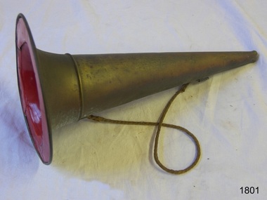 Flagstaff Hill Maritime Museum and Village
Functional object - Megaphone
This megaphone's conical shape amplifies the sound from the narrow end and would have been used to signal a warning or give instructions. Its design is similar to an earlier brass fog horn used on a marine vessel, as it has a wide brim that allows it to be free-standing, and a shoulder rope makes it portable and frees up the user's hands. The narrow end is shaped into a mouthpiece. The megaphone may have been used at sea foghorn on a vessel, although it has no reeds for the sound, or used by a leader of a band or a fireman or other similar uses. This megaphone's conical shape is based on the centuries-old ram's horn or horn from other animals, used to amplify sound to make it travel a long distance or be heard above other sounds. It represents a similar instrument made in the 19th century and used as a signal or to give instructions, such as on a vessel at sea, to a lifesaving team, or in a marching band. Megaphone; brass conical shape with an opening at both ends and a join near the wide end. The wide opening has a broad brim and is painted red inside. A brass ring is attached near each opening and a narrow rope is attached to each ring. warrnambool, flagstaff hill maritime museum and village, fog horn, marine equipment, navigation, warning signal, maritime, nautical, fireman, captain, shoulder rope, signal, safety equipment -
 Flagstaff Hill Maritime Museum and Village
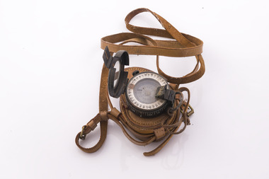
Plane Compass, 1941-1943
This compass is the type used by an artillery unit of the Australian Military Forces during World War 2 and made by J W Handley. Although having owned the factory site since 1935 at 657 Victoria St J W Handley began to produce various items for the Australian Military forces after purchasing and expanding the factory to 655 Victoria St. It appears that he, or some one else may already have been occupying the site for industrial purposes, such as (Manufacturing, Foundry and Electroplating) since at least 1929. J W Handley Pty Ltd was actively producing items for the Military during the war years, a newspaper article from 1939 shows the factory in production and employing 420 people during 1939. J W Handley after the war moved into producing other non military items including a range of fishing reels. The company ceased trading in 1987 and was deregistered as J W Handley Pty Ltd in 1990.The item demonstrates the industrial capability of Australia at the start of World War 2, this item is actively sort by collectors of Australian Military memorabilia and represents a time in Australian history when the country was at war and the general population was concerned about an invasion from Japanese forces. It also therefor is of social significance as many Australians served in the Military forces at that time and the item is complete and in very good condition.A plane table compass, sometimes referred to as a trough compass, used by surveyors and artillery crew to accurately establish magnetic north. The compass is precision machined of brass material with a long needle to ensure accuracy. The compass scale is marked with a centre zero (for magnetic north) and graduations indicating plus and minus five degrees. The compass is housed in a protective wooden case with a sliding lid. The lid has a brass slide which locks the compass needle during periods when the compass is not in use.J.W.H./V Mark 11 D�D. Made by J W Handley Richmond Melbourne, Victoria. Serial number 1333 on boxflagstaff hill, warrnambool, shipwrecked-coast, flagstaff-hill, flagstaff-hill-maritime-museum, maritime-museum, shipwreck-coast, flagstaff-hill-maritime-village, trough compass, navigation instrument, surveyor's instrument, j w handley, artillery, australian army, trough, plane compass, world war 2 -
 Flagstaff Hill Maritime Museum and Village
Instrument - Azimuth Compass, Early 20th Century
Negretti and Zambra 1850-1980s were optical instrument makers and mathematical instrument makers based in London, England. The firm of Negretti and Zambra was established in 1850 by Henry Negretti and Joseph Zambra who had formed a partnership. Their skill was immediately apparent when exhibiting at the 1851 Great Exhibition at Hyde Park, they were the only English instrument makers to receive a prize medal for meteorological instruments, resulting in their appointment as instrument makers to the queen, Greenwich observatory, and the British Meteorological Society. In 1853, when the Crystal Palace was re-erected in Sydenham, Negretti and Zambra became the official photographers of the Crystal Palace Company, which allowed them to photograph the interior and grounds of the new building. The firm made use of this access to produce a number of stereographs. Between 1855 and 1857 Negretti and Zambra commissioned photographer Pierre Rossier to travel to China to document the Second Opium War. Although Rossier subsequently was unable to accompany to Anglo-French forces in that campaign, he nevertheless produced a number of stereographs and other photographs of China, Japan, the Philippines and Siam (now Thailand), which Negretti and Zambra published and that represented the first commercial photographs of those countries. In 1856 Negretti and Zambra sponsored a photographic expedition to Egypt, Nubia and Ethiopia conducted by Francis Firth. In 1864 Negretti and Zambra (themselves) photographed Shakespeare's House at Stratford on Avon. A sepia photograph was then pasted onto card 4" × 2.5". This was then presented to visitors to the Crystal Palace to enable them to compare it with the model erected by Mr E. T. Parr in the Centre Transept. The card itself is headed "Crystal Palace April 23rd 1864." That year they also published a book, titled A Treatise on Meteorological Instruments, (which was reprinted in 1995). Throughout World War One Negretti and Zambra were entirely engaged in the production of various instruments for the Ministry of Munitions. They developed many instruments for the Air Ministry including a mercury-in-steel distance thermometer for taking the oil and air temperatures in aircraft which was patented in 1920. In 1946 the company went private and in 1948 the company was made public, and by 1950 Negretti and Zambra had 821 employees in Britain. In order to increase production and to safeguard future development in 1964, they purchased a modern factory at Aylesbury for all their production. In 1981 Negretti and Zambra were taken over by a group of financial institutions in the form of Western Scientific Instruments and in 1985 the company was acquired by Meggitt Holdings.The subject compass is just one type of the many marine and scientific, optical items this company produced over it’s life time. Negretti and Zambra were prolific manufactures of types of items as well as being very prominent in photography pioneering new innervation's and sponsoring expeditions to little known countries to document peoples daily lives and culture through photography.Azimuth compass on tripod in a fitted wooden box with a round spirit level included, lid of box has three indented circles where the legs of the compass fit when it is set up for use. Stamped "C.M.O. 9" on with Maker Negretti & Zambra London.flagstaff hill, warrnambool, flagstaff-hill, flagstaff-hill-maritime-museum, shipwreck-coast, flagstaff-hill-maritime-village, azimuth compass, nautical instrument, negretti & zambra london, navigational instrument, compass -
 Flagstaff Hill Maritime Museum and Village
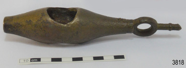
Taffrail log, Late 19th Century
John Bliss (1795-1857) was born in Connecticut, trained as a silversmith and clock maker in Vermont, and began in business as a jeweller in New York around 1830. In 1834, now trading as Bliss & Creighton, he made and marketed chronometers and other items for navigational use. The firm became John Bliss & Son in 1855 and John Bliss & Co. in 1857. It remained in business until 1957. Truman Hotchkiss, a sea captain from Stratford, Connecticut, designed a mechanical Taff rail log in which the recording mechanism was placed on taffrail (or upper part of the stern) of the ship. After acquiring the rights to Hotchkiss’s patents of 1864 and 1867, John Bliss & Co. began advertising the "American Patent Taffrail Log." The firm also offered mechanical logs based on patents granted to John Bliss, Jnr and his brother George, as well as English instruments based on Massey’s and Walker’s patents.The SPECULANT is historically significant as the largest ship to have been registered in Warrnambool, and is believed to have been the largest barquentine to visit Melbourne. It is evidence of the final days of large commercial sailing vessels involved in the Victorian and New Zealand timber trade. The SPECULANT is listed on the Victorian Heritage Register VHR S626John Bliss Taffrail ship log incomplete, rope and spinner missing used on the vessel "Speculant " ( See "Notes" at the end of this document for further information) "Taffrail Log Patented Nov .. Apr .. June .. Sep 1.", dial registers 1/4, units and 10's. with 3 sets of dials, 2 with hands missingflagstaff hill, warrnambool, shipwrecked-coast, flagstaff-hill, flagstaff-hill-maritime-museum, maritime-museum, shipwreck-coast, flagstaff-hill-maritime-village, la bella, speculant, cumming and ellis, international timber trade, p. j. mcgennan and co. warrnambool, capt. james jacobsen, first mate: james munro, second mate: john scerling;, cook: b bond; a. b., s: v. sundring, s: h. hansen, s: b. melson, s: h. johnston, s: t. trumblen;, ordinary seaman: r. thompson, cape patton, c. ramsden, log, taffrail ship's log, ship log, john bliss, patent log, peter mcgennan -
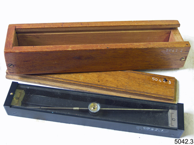
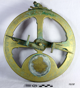 Flagstaff Hill Maritime Museum and Village
Instrument - Mariner's astrolabe
This representative example demonstrates a mariner’s astrolabe. Historical examples are rare. There are less than one hundred known to exist and most of these have been recovered from shipwrecks, many from Spanish and Portuguese vessels. An astrolabe is a measuring device once used to navigate the seas by observing the sun and stars to measure their altitude. The measurement of altitude could then be used to calculate the ship’s latitude but at that time in history there was no means of measuring longitude. The body of the navigational astrolabe was cast brass and much heavier, and less complicated than the variety used on land. The heavier weight and cut-away shape reduced the effect of the wind and waves when trying to use it at sea. A mariner’s astrolabe or ‘star finder’ is a simplified version than that used by Arabic astronomers to find the altitude of the sun and stars above the horizon, and time of the sunrise and sunset. It is a forerunner to the quadrant, octant and sextant and was popular for about 200 years over the 1500s and 1600s to find the latitude of a ship at sea. The user held the astrolabe at eye level and, usually with assistance, aligned the stars through the two small sights (pinnules), then read the altitude indicated by the pointer on the arm. It could also be used to sight the sun by holding it lower down, aiming it at the sun, and adjusting it until the sun shone through both pinnules. This astrolabe is an example used to demonstrate the mariner’s astrolabe, which was navigational tool of the 1500s and 1600s, in the time before longitude was able to be determined. It is a forerunner to modern navigation technology. Mariner’s astrolabe – a representative example. A gold painted, disc shaped object with cut outs and revolving arm in centre. The arm has two sights attached at right angles. The top has a ring attached. Measurements are marked in degrees in a circular scale around outer edge.flagstaff hill, warrnambool, maritime village, maritime museum, flagstaff hill maritime museum & village, shipwreck coast, great ocean road, navigation instrument, navigation tool, navigation, astrolabe, mariner’s astrolabe, measure latitude, measure altitude, arabic navigation, measuring device, star finder, astronomy, marine tool, marine instrument -
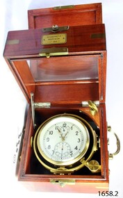 Flagstaff Hill Maritime Museum and Village
Instrument - Chronometer
First State Watch Factory: This factory was founded in 1930 under orders from Joseph Stalin, the "First State Watch Factory" was the first large-scale Soviet watch and mechanical movement manufacturer in the USSR. Via its USA-based trading company (Amtorg), the Soviet government bought the defunct Ansonia Clock Company of Brooklyn, New York in 1929, and the "Dueber-Hampden Watch Company of Canton", based in Ohio. The soviets moved twenty-eight freight cars full of machinery and parts from the USA to Moscow in order to establish the factory. Twenty-one former "Dueber-Hampden" watchmakers, engravers and various other technicians helped to train the Russian workers in the art of watchmaking as part of the Soviet's first five-year plan. The movements of very-early products were still stamped "Dueber-Hampden, Canton, Ohio, USA" (examples of these watches are very collectible today). In 1935 the factory was named after the murdered Soviet official Sergei Kirov. During the second world war, as the Germans closed in on Moscow in 1941, the factory was hurriedly evacuated to (Zlatoust USSR). By 1943 the Germans were in retreat, and the factory was moved back to Moscow, adopting the "First Moscow Watch Factory" name. In 1947 the first wristwatches under the brand name "Pobeda" and the first Marine Chronometers and Deck watches were produced. By 1951 the production of wristwatches had increased to 1.1 million. In 1975 new machinery and equipment for manufacturing complex watches were imported from Switzerland. The first chronograph called "Okean" (3133) was produced for the space station "Soyuz-23."The Chronometer is of recent manufacture and an excellent example of the type of instrument used to navigate the seas in the 19th century. It is of good quality and of a type regarded as very accurate and well made. The maker, First Watch Factory, has a dept that is still producing the "8916" standard Chronometer for horologists and collectors. Marine chronometer of Russian make in wooden case, metal handles on sides, inscription on a metal plaque on the front of the case. Polished square wooden outer case with green felt lining and, a leather carrying strap and buckle. Outer case is hinged and has a metal latch on the front. Outer case has a red velvet covering with a button and loop closure. Inscription on box are in Russian & translate as follows: ХРОНОМЕТР, = CHRONOMETER МОРСКОЙ, = NAUTICAL ГОСТ, 8916-77 = Gost ЛОЛ ЕТ, on dial face = LOL ETflagstaff hill, warrnambool, shipwrecked-coast, flagstaff-hill, flagstaff-hill-maritime-museum, maritime-museum, shipwreck-coast, flagstaff-hill-maritime-village, chonometer, russian, watch factory, marine, navigational instrument -
 Flagstaff Hill Maritime Museum and Village
Instrument - Ship Log
The ship's log part, called a fish, is likely to be from a mechanical taffrail log system. It was recovered from the wreck site of the barque, the 1840-1852 Grange. There are no marks on the fish to identify its maker or model. It is part of the John Chance Collection. This ‘fish’ is part of an early to mid-1800s ship's log. It would likely have been part of a taffrail log connected to a rotor (also called propeller, spinner) by a strong line, and the other end connected by a line to a dial mounted on the taffrail, or stern rail, at the stern of the vessel. As the propeller rotated through the water it would spin the log, which in turn would cause a number to register on the dial, showing the current speed in knots; one knot equals one nautical mile per hour. TAFFRAIL LOGS A taffrail log is a nautical instrument used for measuring the speed of a vessel, providing vital navigational information to be calculated, such as location and direction. A log has been used to measure the speed of a vessel since the 1500s. A simple piece of wood was tied to a long line and thrown into sea at the back of the vessel. The rope was knotted all along at equal distances apart. On a given signal the log line was pulled back into the vessels, the knots counted until the log came up, then the figures were calculated by a navigator In 1802 the first successful mechanical log available for general use was invented by Edward Massey. It had a rotor 'V' section connected to a recording mechanism. The water’s movement rotated the rotor, which intern sent the movement to the recorder. There are examples of this invention available to see in some of the maritime museums. Thomas Walker, nephew of Edward Massey, improved on Massey’s design, and Walker and his son took out a patent on the A1 Harpoon Log. In 1861. Both Massey and Walker continued to improve the designs of the taffrail log. New designs were still being introduced, even up to the 1950s. THE GRANGE, 1840-1858- The wooden barque ’Grange’ was a three-masted ship built in Scotland in 1840 for international and coastal trade. On March 22, 1858, the Grange set sail from Melbourne under Captain A. Alexander, carrying a cargo of ballast. The barque had left the Heads of Phillip Bay and was heading west along the Victorian coast towards Cape Otway. The ship struck Little Haley’s Reef at Apollo Bay due to a navigational error and was stuck on the rocks. The crew left the ship carrying whatever they could onto the beach. Eventually, the remains of the hull, sails and fittings were salvaged before the wreck of the Grange broke up about a month later. About 110 years later, in 1968, the wreck of the Grange was found by divers from the Underwater Explorers Club of Victoria. They were amazed to find a unique, six to nine pound carronade (type of small cannon) and a cannonball on the site. There have been no other similar carronades recorded. In that same year the anchor of the Grange was recovered by diver John Chance and Mal Brown. The ship’s log is significant historically as an example of hardware used when building wooden ships in the early to mid-19th century. The ship’s log is historically significant as an example of the work and trade of blacksmith. The ship’s log also has significant as it was recovered by John Chance, a diver from the wreck of the Grange in the 1968. Items that come from several wrecks along Victoria's coast have since been donated to the Flagstaff Hill Maritime Village’s museum collection by his family, illustrating this item’s level of historical value. The ship’s log is historically significant for its association with the 1840s wooden barque, the Grange. The Grange is an historical example of a Scottish built vessel used for international and coastal trader of both cargo and passengers in the mid-19th century. The Grange is an example of an early ship, designed with a wooden hull. It is significant as a ship still available to divers along the south coast of Victoria, for research and education purposes. The Grange is an example of a mid-19th century vessel that carried a weapon of defence onboard. Ship log fitting, called a fish; part of a brass navigational instrument, likely to be from a taffrail log. The metal is a tan colour and has rough surface with a sheen, and discolouration in places. Its basic shape is a hollow cylinder with ends tapering to a smaller size. In the centre there are opposing openings cut out, showing a rough texture inside. One end on the cylinder is closed with a ring and shank installed, fixed by an embedded screw through the end of the cylinder. There are no inscriptions.flagstaff hill, warrnambool, flagstaff hill maritime museum, maritime museum, shipwreck coast, flagstaff hill maritime village, great ocean road, west coast trader, apollo bay, mid-19th century shipwreck, the grange, scottish barque, little henty reef, captain a alexander, underwater explorers club of victoria, vhr 5297, coastal trader, wooden shipwreck, john chance, wooden ship, taffrail log, marine instrument, marine technology, navigation, nautical instrument, mechanical log, nautical navigation, navigation equipment, scientific instrument, ship log, ship log register, ship speed, taff rail log, patent log, towed log, taffrail log fish, edward massey, thomas walker -
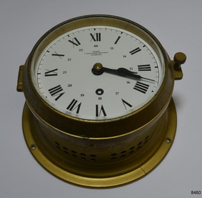
 Flagstaff Hill Maritime Museum and Village
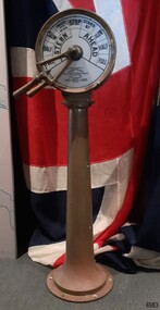
Equipment - Ship's Telegraph section, Chadburn & Sons, 1875-1898
This is the Bridge Section of a ship’s telegraph and is a Duplex Gong model, made by Chadburn & Son of Liverpool. This duplex gong model would sound two signals whenever the navigational commands were given by the ship’s pilot to change the speed or direction. The ship’s telegraph was installed on Flagstaff Hill’s exhibit of the 1909 Hobart, Tasmania, ferry “SS Rowitta” installed in 1975 and enjoyed for more than 40 years. Communication between the ship’s pilot and the engine room in the late 19th century to the mid-20th-century was made with a system called an Engine Order Telegraph (E.O.T.) or ship’s telegraph. The equipment has two parts, the Bridge Section and the Engine Room Section. The Bridge Section is usually mounted onto a pedestal, and the Engine Room Section is attached to a vertical surface. The standard marine commands are printed or stamped around the face of the dial and indicated by a pointer or arrow that is usually moved by a rotating brass section or handle. The ship’s pilot stationed on the Bridge of a vessel sends his Orders for speed and direction to the Engine Room with the E.O.T. He moves the lever or levers, depending on the number of engines the ship has, to change the indicator on the Bridge Section’s dial to point in the new direction and speed of travel. This change causes the Orders to be duplicated on the Engine Room Section’s dial and a bell or bells to signal the change at the same time. The engineer then adjusts the ship’s engines and steering equipment to follow the pilot’s Order. CHADBURN & SON, Liverpool- Chadburn Brothers, William and C.H., were joint inventors and well-established makers of optical and scientific instruments and marine gauges. The firm was granted the Prince Albert Royal Warrant in the late 19th century. In 1870 William Chadburn applied for a patent for his navigational communication device for use on ships. By 1875 Chadburn & Son was producing the brass Engine Order Telegraph in its plant at 71 Lord Street, Liverpool. In 1911 the ship RMS Titanic was launched, fitted with Chadburn & Sons E.O.T. The Chadburn Ship Telegraph Company Limited was registered in 1898 to take over Chadburn & Sons. In 1903 a large factory at Bootle, near Liverpool, and their products were being sold overseas. In 1920 electric-powered telegraphs were developed. In 1944 the name changed to Chadburn’s (Liverpool) Limited. In 1968 the company became Chadburn Bloctube Ltd. In 2000 the company, now Bloctube Marine Limited, was still manufacturing ship telegraphs. SS ROWITTA: - The 1909 steam ferry, SS Rowitta, was installed as an exhibit at Flagstaff Hill in 1975 and was enjoyed by many visitors for 40 years. Rowitta was a timber steam ferry built in Hobart in 1909 using planks of Huon and Karri wood. It was a favourite of sightseeing passengers along Tasmania’s Tamar and Derwent rivers for 30 years. Rowitta was also known as Tarkarri and Sorrento and had worked as a coastal trading vessel between Devonport and Melbourne, and Melbourne Queenscliff and Sorrento. In 1974 Rowitta was purchased by Flagstaff Hilt to convert into a representation of the Speculant, a historic and locally significant sailing ship listed on the Victorian Heritage Database. (The Speculant was built in Scotland in 1895 and traded timber between the United Kingdom and Russia. Warrnambool’s P J McGennan & Co. then bought the vessel to trade pine timber from New Zealand to Victorian ports and cargo to Melbourne. It was the largest ship registered with Warrnambool as her home port, playing a key role in the early 1900s in the Port of Warrnambool. In 1911, on her way to Melbourne, it was wrecked near Cape Otway. None of the nine crew lost their lives.) The promised funds for converting Rowitta into the Speculant were no longer available, so it was restored back to its original configuration. The vessel represented the importance of coastal traders to transport, trade and communication in Australia times before rail and motor vehicles. Sadly, in 2015 the time had come to demolish the Rowitta due to her excessive deterioration and the high cost of ongoing repairs. The vessel had given over 100 years of service and pleasure to those who knew her. This Bridge section of a ship’s Engine Order Telegraph, used with an Engine Room section, represents late-19th century change and progress in communication and navigation at sea. This type of equipment was still in use in the mid-20th century. The object is significant for its association with its maker, Chadburn & Son, of Liverpool, a well-known marine instrument maker whose work was recognised by English Royalty, and whose products were selected to supply similar equipment for use on the RMS Titanic. This ship’s telegraph is connected to the history of the Rowitta, which was a large exhibit on display at Flagstaff Hill Maritime Village from the museum’s early beginnings until the vessel’s end of life 40 years later. The display was used as an aid to maritime education. The Rowitta represents the importance of coastal traders to transport, trade and communication along the coast of Victoria, between states, and in Australia before rail and motor vehicles. The vessel was an example of a ferry built in the early 20th century that served many different roles over its lifetime of over 100 years. Bridge section of a Ship’s Telegraph or Engine Order Telegraph (E.O.T.). The round double-sided, painted glass dial is contained within a brass case behind glass. It is fitted onto an outward tapering brass pedestal with a round base. The brass indicator arrows between the handles point simultaneously to both sides of the dial when moved. An oval brass maker’s plate is attached to the top of the case. The dial’s faces have inscriptions that indicate speed and direction, and the front face and plate include the maker’s details. A serial number is stamped on the collar where the dial is fitted to the pedestal. The ship’s telegraph is a Duplex Gong model, made by Chadburn & Son of Liverpool. Dial, maker’s details: “PATENT “DUPLEX GONG” TELEGRAPH / CHADBURN & SON / TELEGRAPH WORKS / PATENTEES & MANUFACTURERS / 11 WATERLOO ROAD / LIVERPOOL” LONDON / 105 FENCHURCH STREET” “NEWCASTLE / 85 QUAY + SIDE” “GLASGOW / 69 ANDERSON QUAY” “PATENT” Dial instructions: “FULL / HALF/ SLOW / FINISHED WITH ENGINES / STOP STAND BY / SLOW / HALF / FULL / ASTERN / AHEAD” Maker’s plate: “CHADBURN / & SON / PATENT / LIVERPOOL” Serial number: “22073”flagstaff hill, warrnambool, maritime village, maritime museum, shipwreck coast, great ocean road, engine order telegraph, e.o.t., navigational instrument, communication device, ship’s telegraph, engine room section, bridge section, rms titanic, chadburn & son, chadburn brothers, william chadburn, chadburn ship telegraph company, chadburns, duplex gong, liverpool, ss rowitta, navigation, marine technology, pilot’s orders, steam power, hobart, tasmania, devonport, tasmanian-built, ferry, steam ferry, steamer, 1909, early 20th century vessel, passenger vessel, tamar trading company, launceston, george town, sorrento, tarkarri, speculant, peter mcgennan, p j mcgennan & co. port phillip ferries pty ltd, melbourne, coastal trader, timber steamer, huon, karri, freighter, supply ship, charter ferry, floating restaurant, prawn boat, lakes entrance -
 B-24 Liberator Memorial Restoration Australia Inc
Bubble sextant, Henry Hughes & Son, c.1930s
These instruments were used on aircraft to obtain the altitude of the sun or other celestial body to aid navigation. This particular one came from a former RAAF pilot.This bubble sextant, complete with original wooden storage case with leather strap, was manufactured c.1930s. Black and metallic, it has a mirror in the middle, various knobs on the sides and a cylindrical handle on each side.sextant, altitude, navigation, instrument -
 Queenscliffe Maritime Museum
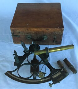
Instrument - Sextant in wooden box
Sextant used by Bill Virtue, an apprentice on the Adelaide Steamship Co. ship 'Manoora' in 1957Label on the book indicates that the sextant was examined by the National Physical Museum Kew observatory, Richmond Surrey England in 1901Sextant in timber box made around 1901 in the UK.Examined by National Physical Museum Kew Observatory Richmond Surrey Eng 1901sextant, navigation, 'manoora', adelaide steamship co, bill virtue -
 Queenscliffe Maritime Museum
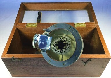
Instrument - Bearing compass hand held
Formerly of Station Works, Wakering Road, Barking, Essex, Henry Browne & Son were important British compass makers. The company was founded in the nineteenth century in Barking and London. They were respected English instrument makers who made fine quality compasses, ships clocks, inclinometers, sextants and chandlery items for over 140 years. Their "Dead Beat" compass, which was well dampened to reduce oscillation, was fitted to many Allied ships during the Second World War. Sestrel was their famous Trade Mark brand. The company was sold to John Lilley & Gillie Ltd and SIRS Navigation, both UK companies, in 1993. Example of a hand held compass used in WWIIA Sestrel hand held bearing compass with wooden handle in own glass fronted, wooden container.Sestrel Henry Browne & Son Ltd Barking Londoncompass, navigation -
 Queenscliffe Maritime Museum
Equipment - Sounding lead line
Although the provenance cannot be confirmed it is believed that this lead possibly originated from the SS Time.Since at least the sixth century B.C. the sounding lead or sounding weight was in use in the Mediterranean area for maritime navigation. It is the oldest known marine navigational instrument and it remained a primary navigational aid in coastal waters and rivers well into the twentieth century.A sounding lead with rope line attached. One surviving leather fathom depth marker is spliced into the rope.sound lead, navigation -
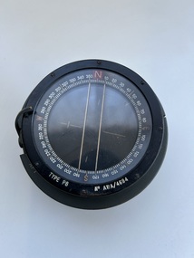 Moorabbin Air Museum
Instrument (Item) - Compass Navigational Type P8 Reference G6A/0726. ( 2 Units), Compass Navigational Type P8 Reference G6A/0726
-
 Forests Commission Retired Personnel Association (FCRPA)
Prismatic Compass with leather case and strap, Ex Army 1940s
... instrument which was used extensively by the Forests Commission... instrument which was used extensively by the Forests Commission ...A prismatic compass is a common navigation and surveying instrument which was used extensively by the Forests Commission The compass most commonly used to run a traverse line. The compass calculates bearings of lines with respect to magnetic needle. A magnetic deviation correction was needed to convert the reading to a true bearing The compass could also determine angles between the traverse and waypoints (such as hilltop features). Commonly used for navigation. Largely replaced by modern GPS technology.Ex Army WW2 prismatic compass with leather case and strap. Rugged design and made of metal the internal compass plate floats on oil to help it stabilise The user lines up the direction of travel with the hair sightline in the fliptop cover and readings are taken through the viewfinder prism (hence the name).forest measurement, surveying, forests commission victoria (fcv) -
 Flagstaff Hill Maritime Museum and Village
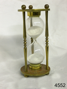
Instrument - Hourglass
An hourglass or sandglass is an instrument for measuring a defined time and can be used perpetually by simply turning it over immediately the top bulb empties. The clear blown glass is shaped into two equal sized bulbs with a narrow passage in the centre and contains uniform sized sand or glass particles in the lower bulb. The width of the neck regulates the constant flow of the particles. The glass is held in a stand with top and bottom of equal shape and size. Hourglasses can measure an infinite variety of time by gauging the size of the particles, the shape and size of the bulbs and the size of the passage between the bulbs, thus measuring hours or minutes or even seconds. Generally an hourglass sits between discs of wood at the ends, which are joined by long wooden spindles between the ends and tightened by screw caps. The length of time can be adjusted by adding or removing sand particles. The use of the marine sandglass (or hourglass) has been recorded in the 14th century in European shipping. A one minute sandglass was used in conjunction with the ship’s log for ‘dead reckoning’, (see below) that is, for measuring the ship’s speed through the water. They were also used to regulate ringing the ship’s timetable; for example a 4 hour sandglass was used for the length of the sailors’ watch, and a half hour timer for taking of readings for the ship’s log; the ship’s bell would be rung every half hour. It was usually the role of the cabin boy to watch and turn the sandglasses over at the exact time of them emptying their upper chambers and to ring the ship’s bell. Hourglasses have been used historically for many hundreds of years. Some have been used for timing church sermons, in cooking, in industry and at sea. Even today they are used for measuring the cooking time of eggs and timing a player’s turn in games such as Boggle and Pictionary. The sandglasses at sea were gradually replaced in the late 1700’s to early 1800’s by the more accurate chronometers (marine clocks) when they became reliable instruments. DEAD RECKONING (or Deduced Reckoning) Dead reckoning is the term used to describe the method of calculating the ship’s position from its speed and direction, used in early maritime travel, mostly in European waters. Both the (1) speed and the (2) direction of travel were recorded on a Traverse Board at half-hourly intervals during a helmsman’s watch of 4 hours. The navigator would record the readings in his ship’s log, plot them on his navigational chart and give his updated course directions to the next helmsman on watch, along with the cleared Traverse Board. This was a very approximate, but none-the-less helpful, method of navigation. The wooden Traverse Board was a simple pegboard with a diagram of a compass with eight peg holes along the radius to each of the compass points, plus a grid with ascending half hours in the left column and increasing ship’s speed in knots in a row across the column headings, with a peg hole in each of the intersecting cells. A number of wooden pegs were attached to strings on the board. By placing one peg consecutively in the direction’s radius hole, starting from the centre, and the speed holes when the half hourly reading was taken, a picture of speed and direction for the whole 4 hour watch was created. (1) To measure the ship’s speed a one minute hourglass timer was usually used to measure the ship’s speed through the water and help to calculate its longitude. A rope, with knots at regular standard intervals and a weight such as a log at the end, would be thrown overboard at the stern of the ship. At the same time the hourglass would be turned over and a seaman would start counting the number of knots on the rope that passed freely through his hands as the ship travelled. When the timer ran out the counting would be stopped. A timer of one minute (one-sixtieth of an hour), knots spaced one-sixtieth of a nautical mile apart, and simple arithmetic easily gave the speed of the ship in nautical miles per hour ("knots"). This would be recorded every half hour. The speed could however be inaccurate to the travel being affected by ocean currents and wind. (2) To calculate the ship’s direction a compass sighting would be recorded each half hour.Marine hourglasses or sandglasses were used from around the 14th to 19th century during the time of sailing ships. This hourglass is representative of that era, which is during the time of the colonisation of Australia. Hourglass or sandglass; an instrument used to measure time. Two equal sized clear glass bulbs joined with a narrow passage between them, containing equal sized particles of sand grains in lower bulb. Glass sits in a brass collar at each end, in a frame comprising 3 decorative brass columns or posts, each attached top and bottom, using round screw-on feet, to round brass discs. Disc have Roman numerals for the numbers 1 - 12 pressed into their inner surfaces and hieroglyphics on the outer surfaces. Roman numerals on inner surface of discs " I II III IV V VI VII VIII IX X XI XII " Hieroglyphics impressed on outer surface of discsflagstaff hill, warrnambool, shipwrecked coast, flagstaff hill maritime museum, maritime museum, shipwreck coast, flagstaff hill maritime village, great ocean road, horology, hourglass, hour glass, sandglass, sand glass, timing instrument, dead reckoning, deduced reckoning, finding latitude at sea, sandglass with hieroglyphics and roman numerals, hourglass with hieroglyphics and roman numerals, brass hourglass -
 Flagstaff Hill Maritime Museum and Village
Instrument - Chronometer or Marine Clock
... instrument in use in the early to the mid-20th century. The maker ...This chronometer was made around 1936 and has been on display at Flagstaff Hill for over 40 years as part of the exhibit of the ‘Reginald M’, an Australian-built, 19ss, coastal trader vessel. A chronometer is an accurate mechanical instrument used for measuring time. It is constructed carefully to remain stable even under the changing conditions of seafaring life such as temperature, humidity and air pressure. The Master or Navigator of a ship could use the chronometer and the positions of celestial bodies to calculate the ship’s latitude at sea. In 1905 the business Chronometerwerke GmbH was formed in Frankfurt, Germany, to supply the country with high-quality mechanical chronometers and ship clocks for their maritime trade, making the country independent of other international suppliers such as those in England. In 1938 the firm was renamed Wempe Chronometerwerke. The business continues today. Its products now include its well-known chronometers, battery-powered ship clocks, ship’s bell clocks, barometers, barographs, thermometers, hygrometers, comfort meters to measure temperature and humidity, and wristwatches. The company also performs chronometer testing facilities for the State’s Weights and Measures office. The article written by Givi in July 2022 “The Basics of Marine Meteorology – a Guide for Seafarers” refers to the weather’s signs and patterns being repeated over and over, and the recording of these observations helps forecasters predict changes in the weather. The chronometer is an example of a mechanical navigational marine instrument in use in the early to the mid-20th century. The maker is significant as part of a German government initiative to be self-sufficient in the production of good quality marine technology. This chronometer is significant as part of the exhibit, the Australian-built vessel, 1922 coastal trader ‘Reginald M’, listed on the Australian Register of Historic Vessels and on display for over 40 years.Marine chronometer or marine clock, brass case, glass cover, Roman numerals, 24-hour numbers beside them. Two black hands, a keyhole for winding and ventilation holes in the side. The base has a collar with four machined mounting holes. Inscriptions are on the clock’s face."Made in Germany" and "WEMPE / CHRONOMETERWERKE / HAMBURG"flagstaff hill, flagstaff hill maritime museum and village, warrnambool, maritime museum, maritime village, great ocean road, shipwreck coast, marine meteorology, horology, chronometer, marine technology, latitude, marine navigation, mechanical instrument, scientific instrument, ship clock, chromometerwerke gmbh, wempe chronometerwerke, marine clock -
 Flagstaff Hill Maritime Museum and Village
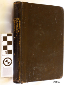
Book - Textbook, Introduction to Modern Geography
This mid-19th century scientific reference book, Introduction to Modern Geography, explains geography and astronomy using the globe of the world as a teaching aid. The inscription connects this book to the Bobinawarrah Public Library but research to date has found no further details about the library. The rural area was settled in 1859, but in 2016 its population was only 87. It is situated about 21 kilometres south of the City of Wangaratta, in Northeast Victoria. In 2024 the local community received a grant for preservation of its almost 100-year-old Bobinawarrah Memorial Hall which displays an honour board of the Pioneers of Bobinawarrah 1859-1959. The donor of the book lived in Warrnambool. ABOUT THE AUTHOR, James Thomson (1786-1849): - James Thomson was a British Irish mathematician. He became Professor of Mathematics at the University of Glasgow. He wrote many school textbooks and reference books, one of which was Introduction to Modern Geography, first published in Belfast in 1827, and revised and published in over 20 more editions. Thomson tutored two of his several children at home. His older son James Thomson (1822-1892) became an engineer and physicist. His younger son William Thomson (1824-1907) became Professor of Natural Philosophy from 1846-1899 at the University of Glasgow, and later the 1st Baron of Kelvin, famous for his designs of nautical instruments such as the navigational compass and sounding equipment used in the transatlantic installation of sea cable. William was part of the firm that became famous as Kelvin & Hughes Ltd., suppliers of radar and echo sounders to the Ministry of Transport and the Ministry of Defence. The name continued on as Kelvin & Hughes. James Thomson (1786-1849) was a renowned British Irish mathematician and Professor of Mathematics at the University of Glasgow. He was a respected author of many important school books and textbooks that were widely used to provide understanding of arithmetic and geography. Thomson encouraged practical education and held extra classes for young ladies to learn mathematics and geography, which were a novelty at that time. Many of his works were known and used worldwide. This work was published in many editions. It is now considered as culturally significant as a basis for knowledge about our civilisation and has been made publicly available in overseas countries, and republished and reproduced in a readable format, including its diagrams and maps. Book; scientific textbook. The book has a black leather cover. The front cover is blank, but the spine has an embossed gold vertical title within a rectangular border boasting fancy corners. The fly page has a detailed title. The author is James Thomson. It is the Eighteenth edition, published in Simms & McIntyre of London and Belfast in 1845. An inscription connects it to the Bobinawarrah Public Library in Victoria.Spine within a gold border: "THOMSON'S GEOGRAPHY" Fly Page: "AN INTRODUCTION TO MODERN GEOGRAPHY, WITH AN APPENDIX, CONTAINING AN OUTLINE OF ASTRONOMY, AND THE USE OF THE GLOBES. BY JAMES THOMSON, LL.D., PROFESSOR OF MATHEMATICS IN THE UNIVERSITY OF GLASGOW." "Eighteenth Edition" "LONDON: SIMMS AND McINTYRE, ALDINE CHAMBERS, PATERSOSTER ROW; AND DONEGALL -STREET, BELFAST.""1845"flagstaff hill, flagstaff hill maritime museum and village, warrnambool, maritime museum, maritime village, great ocean road, shipwreck coast, introduction to geography, james thomson, reference book, professor thomson's introduction to modern geography, bobinawarrah public library, james thomson mathematician, james thomson engineer, 19th century irish mathematician, irish presbyterian, william thomson 1st baron of kelvin, professor of mathematics, glasgow university, william thomson professor of natural philosophy, introduction to modern geography, outline of astronomy, use of the globes, james thomson ll.d., simms and mcintyre, 1843, scientific book, school book, lord kelvin, baron kelvin of langs, nautical instruments, marine instruments, transatlantic cable, kelvin & hughes, thomson’s geography, astronomy, geography, world globe, cartography, pioneers of bobinawarrah, textbook -
 Flagstaff Hill Maritime Museum and Village
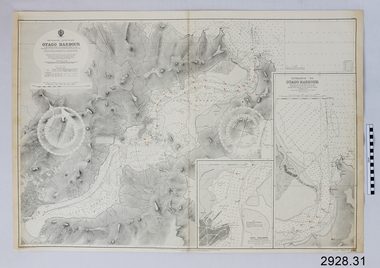
Document - Navigation Chart, British Admiralty, Otago Harbour, Late 19th to Early 20th century
... Navigation charts are used by mariners around the world ...Navigation charts are used by mariners around the world for navigating waterways. This chart was created for Otago Harbour in New Zealand. A ship "Otago' was named after this harbour and was once commanded by renowned maritime author Joseph Conrad. That ship now lies in Otago Bay, in the Derwent River, Tasmania.This navigation chart was published by the British Admiralty cartographer, to aid mariners to navigate the world's water bodies. Navigation charts are still used today, along with other navigational instruments.British Admiralty Navigation Chart - Otago Harbour, South Island, New Zealand. Chart shows insets with finer detail of important sections.warrnambool, shipwrecked-coast, flagstaff-hill, flagstaff-hill-maritime-museum, maritime-museum, shipwreck-coast, flagstaff-hill-maritime-village, shipwrecked-artefact, british admiralty navigation chart, navigation chart, british admiralty, otago harbour, south island, new zealand, otago bay, derwent river, tasmania, joseph conrad -
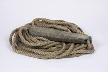
 Flagstaff Hill Maritime Museum and Village
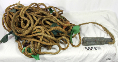
Equipment - Lead line
... instrument used as a depth finder to measure the depth of water under... instrument used as a depth finder to measure the depth of water under ...The lead line or hand lead is a simple navigational instrument used as a depth finder to measure the depth of water under the ship’s keel and to take samples of the sea bed. The long line may be marked at regular intervals with tags of different coloured and textured fabric, such as rope, leather and cloth. Each tag was a code to represent a certain depth. The leadsman’s eyes and hands could distinguish the depth easily as he drew in the lead line, day or night and in poor weather conditions. A standard set of codes for the tags was used so that the depth of the sea could be easily and quickly read. The measurement used was a Fathom, which equals 1.83 metres. The codes were: - 2 fathoms = 2 strips of leather 3 fathoms = 3 strips of leather 5 fathoms = white duck fabric 7 fathoms = red bunting fabric 10 fathoms = leather with a hole 13 fathoms = blue serge fabric 15 fathoms = white duck fabric 17 fathoms = red bunting 20 fathoms = 2 knots The lead weight could be between 7 -14 pounds (3.5 – 6.5kg) and the rope would be approximately 25 fathoms (45m). The hollowed-out end of the weight would hold a stick substance such as tallow or wax, which would pick up samples from the sea bed which would show whether the vessel was close to, or far away from, the shore. The leadsman would stand at the front of the vessel and cast the lead line into the sea. When it hit bottom he would note the tag marker nearest the surface of the water and call out his finding. Then he would haul it up again and examine the kind of matter that adhered to the end of the weight, whether it be sand, mud, gravel, or the colour of it. This information would be given to the ship’s helmsman or navigator and would help indicate the proximity to the land.This handheld lead is an example of early marine navigational equipment used by sailors to travel the seas to measure the depth of the water and sample the nature of the seabed. It helps to understand the history and progress made from the very basic to the sophisticated technology of today.Lead line, sounding line or depth finder. The long length of rope has a heavy lead weight attached to the end. Coloured fabric tags are tied onto the rope at regular intervals, representing different depths. The concave base of weight holds sticky substances such as tallow or beeswax, providing an adhesive surface to collect samples of sea bed like sand, shells or pebbles. flagstaff hill, warrnambool, shipwrecked coast, flagstaff hill maritime museum, maritime museum, shipwreck coast, flagstaff hill maritime village, lead line, depth finder, hand lead, sounding lin, leadsmane, navigation instrument, leadline, hand lead line -
 Flagstaff Hill Maritime Museum and Village
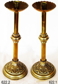
Functional object - Candlesticks, T. Gaunt & Co, circa 1944
This pair of altar lights is from the St. Nicholas Seamen’s Church, 139 Nelson Place, Williamstown, Victoria, and was used during religious services there. The Church was operated by the Mission to Seamen organisation. The par of candlesticks was originally donated by Mrs. R.J. Ewart,as part of the furnishings for the new St Nicholas Seamen's Church in Williamstown, opened in 1944. The candlesticks were made by T. Gaunt & Co. of Melbourne, a manufacturer, importer and retailer of a wide variety of goods including jewellery, clocks and watches, navigational and measuring instruments, dinnerware, glassware and ornaments. Thomas Gaunt photograph was included in an album of security identity portraits of members of the Victorian Court, Centennial International Exhibition, Melbourne, 1888 THE MISSIONS TO SEAMEN (Brief History: for more, see our Reg. No. 611, Set of Pews) The Missions to Seamen, an Anglican charity, has served seafarers of the world since 1856 in Great Britain. It symbol is a Flying Angel, inspired by a Bible verse. Today there are centr4es in over 200 ports world-wide where seamen of all backgrounds are offered a warm welcome and provided with a wide range of facilities. In Victoria the orgainsation began in Williamstown in 1857. It was as a Sailors’ Church, also known as ‘Bethel’ or the ‘Floating Church’. Its location was an old hulk floating in Hobson’s Bay, Port of Melbourne. It soon became part of the Missions to Seamen, Victoria. In the year 2000 the organisation, now named Mission to Seafarers, still operated locally in Melbourne, Portland, Geelong and Hastings. The Ladies’ Harbour Lights Guild was formed in 1906 to support the Missions to Seamen in Melbourne and other centres such as Williamstown. Two of the most significant ladies of the Guild were founder Ethel Augusta Godfrey and foundation member Alice Sibthorpe Tracy (who established a branch of the Guild in Warrnambool in 1920). The Guild continued its work until the 1960s. In 1943 a former Williamstown bank was purchased for the Missions to Seaman Club. The chapel was named St Nicholas’ Seamen’s Church and was supported by the Ladies’ Harbour Lights Guild, the Williamstown Lightkeepers’ Auxiliary and the League of Soldiers’ and Sailors’ Friends. It ceased operation in 1966. A Missions to Seamen Chapel and Recreation Room was a significant feature of ports during the late 1800s and into the 1900s. It seemed appropriate for Flagstaff Hill to include such a representation within the new Maritime Village, so the Melbourne Board of Management of Missions to Seamen Victoria gave its permission on 21st May 1979 for the entire furnishings of the Williamstown chapel to be transferred to Flagstaff Hill. The St Nicholas Seamen’s Church was officially opened on October 11, 1981 and closely resembles the Williamstown chapel. These candlestickrs are significant historically for their origin in the St Nicholas Mission to Seamen's Church in Williamstown, established in 1857 to cater for the physical, social, and spiritual needs of seafarers. It originated in Bristol, England when a Seamen's Mission was formed in 1837. The connection of the candlesticks to the Mission to Seamen highlights the strong community awareness of the life of people at sea, their dangers and hardships, and their need for physical, financial, spiritual and moral support.Candlesticks or altar lights; a pair of two polished brass candlesticks. The wax cup at the top has a scalloped lip, the centre of the stem has a bulbous section, and the base has a cast floral design depicting leaves and grapes. The candlesticks have inscriptions. They were made by T. Gaunt & Co. This pair of Altar Lights is part of the St. Nicholas Seamen's Church Collection. Stamped "T GAUNT & CO."flagstaff hill maritime museum and village, flagstaff hill, warrnambool, maritime museum, maritime village, shipwreck coast, great ocean road, religion, religious service, st nicholas seamen’s church, williamstown, missions to seamen victoria, religious worship, altar light, r j ewart, church furnishing, church lighting, t gaunt & co, candlesticks, altar lights -
 Flagstaff Hill Maritime Museum and Village
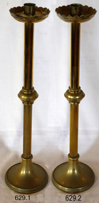
Functional object - Candlesticks, T. Gaunt & Co, circa 1944
This pair of altar lights is from the St. Nicholas Seamen’s Church, 139 Nelson Place, Williamstown, Victoria, and was used during religious services there. The Church was operated by the Mission to Seamen organisation. The par of candlesticks was originally donated by Mrs. M. Jackson, as part of the furnishings for the new St Nicholas Seamen's Church in Williamstown, which opened in 1944. The candlesticks were made by T. Gaunt & Co. of Melbourne, a manufacturer, importer and retailer of a wide variety of goods, including jewellery, clocks and watches, navigational and measuring instruments, dinnerware, glassware and ornaments. Thomas Gaunt's photograph was included in an album of security identity portraits of members of the Victorian Court, Centennial International Exhibition, Melbourne, 1888. THE MISSIONS TO SEAMEN (Brief History: for more, see our Reg. No. 611, Set of Pews) The Missions to Seamen, an Anglican charity, has served seafarers of the world since 1856 in Great Britain. It symbol is a Flying Angel, inspired by a Bible verse. Today there are centr4es in over 200 ports world-wide where seamen of all backgrounds are offered a warm welcome and provided with a wide range of facilities. In Victoria the orgainsation began in Williamstown in 1857. It was as a Sailors’ Church, also known as ‘Bethel’ or the ‘Floating Church’. Its location was an old hulk floating in Hobson’s Bay, Port of Melbourne. It soon became part of the Missions to Seamen, Victoria. In the year 2000 the organisation, now named Mission to Seafarers, still operated locally in Melbourne, Portland, Geelong and Hastings. The Ladies’ Harbour Lights Guild was formed in 1906 to support the Missions to Seamen in Melbourne and other centres such as Williamstown. Two of the most significant ladies of the Guild were founder Ethel Augusta Godfrey and foundation member Alice Sibthorpe Tracy (who established a branch of the Guild in Warrnambool in 1920). The Guild continued its work until the 1960s. In 1943 a former Williamstown bank was purchased for the Missions to Seaman Club. The chapel was named St Nicholas’ Seamen’s Church and was supported by the Ladies’ Harbour Lights Guild, the Williamstown Lightkeepers’ Auxiliary and the League of Soldiers’ and Sailors’ Friends. It ceased operation in 1966. A Missions to Seamen Chapel and Recreation Room was a significant feature of ports during the late 1800s and into the 1900s. It seemed appropriate for Flagstaff Hill to include such a representation within the new Maritime Village, so the Melbourne Board of Management of Missions to Seamen Victoria gave its permission on 21st May 1979 for the entire furnishings of the Williamstown chapel to be transferred to Flagstaff Hill. The St Nicholas Seamen’s Church was officially opened on October 11, 1981 and closely resembles the Williamstown chapel. These candlesticks are historically significant for their origin in the St Nicholas Mission to Seamen's Church in Williamstown, established in 1857 to cater to seafarers' physical, social, and spiritual needs. It originated in Bristol, England, when a Seamen's Mission was formed in 1837. The connection of the candlesticks to the Mission to Seamen highlights the strong community awareness of the life of people at sea, their dangers and hardships, and their need for physical, financial, spiritual and moral support. Candlesticks, also known as altar lights; are a pair of two polished brass candlesticks. The wax cup has a scalloped lip, the centre of the stem has a bulbous section, and the base has a floral design depicting leaves and grapes. They are inscribed 'Made by T. Gaunt & Co.' This pair of Altar Lights is in our St Nicholas Seamen's Church Collection.Inscribed "T. GAUNT & CO.."flagstaff hill, warrnambool, shipwrecked-coast, flagstaff-hill, flagstaff-hill-maritime-museum, maritime-museum, shipwreck-coast, flagstaff-hill-maritime-village, altar lights, mrs. m. jackson, t. gaunt & co., religious service, ladies lightkeepers' auxiliary, mission to seamen victoria, st nicholas seaman’s church williamstown, religious worship, m. jackson, candlesticks -
 Moorabbin Air Museum
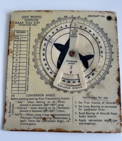
Instrument (item) - Loop Bearing Computer RAAF Form A97
... navigation. Instrument Loop Bearing Computer RAAF Form A97 ... -
 Moorabbin Air Museum
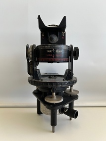
Instrument (item) - Astro Compass A.M (Air Ministry) MKII 6.A/1174
A.M Astro Compass MKII 6.A/1174 2 x