Showing 75 items matching "interest rates"
-
 Orbost & District Historical Society
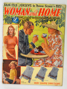
magazine, Woman and Home, September 1940
Women’s magazines during WWII played a “reflecting role,” meaning they cooperated with government agendas while still including topics of readers’ interests Women’s employment rate skyrocketed during WWII. However, even though the number of women working outside the home grew rapidly most of them were still engaged entirely in homemaking. Therefore women’s magazines centered mostly on the stresses and shortages of wartime. Articles as well as advertisements presented information on “product rationing, tips on keeping the family healthy, guidelines for thrifty shopping and advice on how to look good through it all.This is an example of an English women's magazine published during WW11.It gives practical advice on needlework / knitting and evidences the widespread interest in contemporary fashion. In doing so it shows what were the fashionable, but broadly affordable, women's and children's clothing styles of their day. These magazines also reflect women's interests.A 64 pp magazine, titled Woman and Home and Good Needlework Magazine. The front cover has a a coloured picture of a man in a uniform and woman sitting at a round table drinking tea and photographs of knitted jumpers, the patterns of which are inside the magazine.Handwritten on front cover in pencil -Mehlert -
 Orbost & District Historical Society
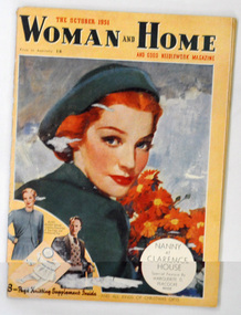
magazine, Woman and Home, October 1951
Women’s magazines just after WWII played a “reflecting role,” meaning they cooperated with government agendas while still including topics of readers’ interests Women’s employment rate had skyrocketed during WWII. However, even though the number of women working outside the home grew rapidly most of them were still engaged entirely in homemaking. Therefore women’s magazines centered mostly on the stresses and shortages of wartime. Articles as well as advertisements presented information on “product rationing, tips on keeping the family healthy, guidelines for thrifty shopping and advice on how to look good through it all.This is an example of an English women's magazine published post WW11.It gives practical advice on needlework / knitting and evidences the widespread interest in contemporary fashion. In doing so it shows what were the fashionable, but broadly affordable, women's and children's clothing styles of their day. These magazines also reflect women's interests.A 64 pp magazine, titled Woman and Home and Good Needlework Magazine. On the front cover is a coloured drawing of a fashionably dressed and made-up woman with red hair and holding a bunch of similarly coloured flowers (gerberas?) At the bottom left are knitted baby clothes - pattern inside - as well as a man and woman wearing fashionable clothing - suggesting patterns are inside the magazine. The magazine cost 1/6 and is dated October 1951.magazine-woman-and-home -
 Ringwood and District Historical Society
Map - Public Land Sale by Thomas Ham, 2000 Acres for Sale - Crown Sections 20, 23, 24 - Ringwood, Victoria - 1855
Two 1850s surveyor's maps on cardboard backing showing area from Melbourne extending East beyond Bulleen and Nunawading. Detailed description of lots for sale and navigational directions to the property from Richmond by Thomas Ham, Victorian public servant, map maker, publisher, lithographer and original Ringwood land owner. Inset map enlarging area between Yarra River and Dandenong Creek, with southern boundary of allotments later forming part of Oban Road, North Ringwood.TRANSCRIPT: "This really valuable Property is now offered to the public for sale, in lots to suit purchasers at the Iow rate of £1 per Acre for 80 acres and upwards, and £1.10s per Acre for any smaller portion. Terms of payment Half Cash, Balance in 6 and 12 months, bearing 8 per cent interest. The Estate is well wooded with Gum, Cherry Tree and Stringy Bark, with Wattle in the valleys of the several creeks. Every lot is Staked and Trenched at the corners marked on the Plan thus - The Surveyor has carefully sub-divided the Property, in order to give every Farm a Creek for Water, Valley for Cultivation, and Hills for House and Grass Paddock. The ROADS have been very carefully laid out so as to give a firm, well drained, and nearly level road to each Homestead. Intending purchasers can readily find the property by the following directions, viz: Start from Richmond Bridge, at Hawthorne, then take the left-hand road to KEW. When at the "Woodman Inn", take the Cotham Road to the right, bearing due east, keep this Road, passing Trainor's "White Horse" Inn, and before you leave the fences, you will see calico bills (see margin) nailed to the Trees on the bush track leading to the Upper Yarra country, follow the Bills till you come to the SOUTH boundary line of the Property, which bears East and West (see Plan) where you will see Bills nailed up "THIS PROPERTY FOR SALE, etc." The Bills from Town lead direct to where Mr. Jull is erecting his Store, and arrangements have been made with him to show the lots to intending purchasers free of charge. At the respective corners of the lots the Bills are nailed up double, with numbers to denote the lot, and that the corner stake is adjacent. Any parties wishing to proceed to the property by way of BULLEEN will find Bills nailed on the Trees, commencing at the NEW INN, at "Wilson's Slip Rail." Keep this Track till you come to the Log Bridge, over the Deep Creek at Bloxhome's Paddock; go through the land now being cleared; keep the track over the hill till you come to an Iron House, you will then be on the property, which Iies to the North and East as per Plan. Follow the Bills till you come to Mr. Jull's Store, etc. etc. Further particulars can be had from the Agent for the Property. THOMAS HAM. " -
 Ringwood and District Historical Society
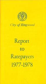
Booklet, City of Ringwood Report to Ratepayers 1977-1978, 1977
Yellow covered community information booklet for Ringwood residents covering Council Representatives' and Service Organisations' contact details, Major Works, Planning (Ringwood Business Centre), Recreation, Litter, Rubbish Tip, Construction of Private Streets (Greenway/Dickasons Road Group), Health and Community Services, Municipal Elections, Rates, Dog Registrations, Overhanging Foliage, Building By-laws, Vandalism, House Numbering, Fire Hazards, Council Finances, and other points of general interest. and local services, sporting, and cultural facilities. Includes two City of Ringwood Free Tipping Vouchers valid until the end of 1978.Mayor's Message - Cr. Lawrie Lawrenson.rinx -
 Ringwood and District Historical Society
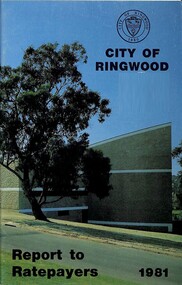
Booklet, Champion Press, City of Ringwood Report to Ratepayers 1981, 1981
Community booklet issued by City of Ringwood for 1981 - covering the facilities and activities of the Ringwood Council and other local organisations and associations. CONTENTS: (page number) Beautification and Leisure Areas 24 Building — General Information 21 Commissioners for Taking Declarations and Affidavits 15 Council Finance 11 Council Meeting Dates 5 Council Representation on various organisations 8 Councillors 6 Elections for Council 10 Emergency Telephone Numbers 51 Health -30 Home Help Service 22 Immunisation Programme 31 Infant Welfare Centres 33 Items of Interest 16 Justices of the Peace 14 Let's Be Neighbourly 20 Library — General 18 Library — Service for our Senior Citizens 23 Major Works 12 Map of municipality 26 Mayor's Message - Cr. F.J. Corr 4 Meals on Wheels 28 Members of Parliament 50 Officers of the Council 9 Proposed Leisure Centre 14 Rate Assistance 11 Rate Payments 10 Recycling Depots 49 Ringwood Cultural Centre 2 Ringwood Festival activities for 1981 29 Standing Committees of Council 5 Swimming Centre 13 Welfare and Community Services 34 rinx -
 Ringwood and District Historical Society
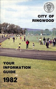
Booklet, City of Ringwood - Your Information Guide 1982, 1982
Community information booklet issued by City of Ringwood for 1982 - covering the facilities and activities of the Ringwood Council and other local organisations and associations. Cover photograph: A.C. Robertson Athletic Field. CONTENTS: (page no.) Beautification and Leisure Areas 16 Building — General Information 26 By-Laws 27 Circuit Bus — Ringwood City 54 Commissioners for taking Declarations and Affidavits 31 Council Meeting Dates 6 Council Representation 7 Councillors 4 Cultural Centre 32 Disabled Persons - Facilities 34 Elections for Council 10 Emergency Telephone Numbers 54 Festival 33 Finance — Council 12 Golf Course 30 Health Home Help Service 24 Immunisation Programme 20 Items of Interest 22 Justices of the Peace 30 Library — General 13 Library — Service for our Senior Citizens 26 Major Works Programme 14 Map of Municipality 28 Mayor's Message – Cr. N.J. Hamilton 2 Meals on Wheels 25 Members of Parliament 52 Officers of the Council 8 Property Records 10 Rates 11 Recycling Depots S3 Regulations 27 Roll — Municipal 10 Swimming Centre 21 Voting — Compulsory 10 Welfare and Community Services 35 rinx -
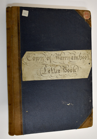
 Warrnambool and District Historical Society Inc.
Book, Register of Mortgagees, Early 20th century
... interest rates. mackay taylor legal firm warrnambool mortgagees ...This Register of Mortgagees comes from the Warrnambool legal firm of Fletcher and Mackay which resulted from the merger of the firms of George Sutherland Mackay and James Fletcher in 1893. G.S. Mackay was a prominent resident of Warrnambool from 1891 to his death in 1926. In the 1920s Mr J. Taylor became a partner in the firm known then as Mackay and Taylor and the firm later known as Mackay Taylor was in operation until the 1990s at 131 Kepler Street. The Register of Mortgagees with dates ranging from 1908 to 1924 comes from the old Mackay Taylor offices in the Kepler Street building.This Register of Mortgagees is of some significance as it contains information on many families living in Warrnambool in the early 20th century, including those of Burleig, Swinton, Uebergang, Turland, Bates, Wood and Paton. The entries have social significance, showing the typical loans taken out at the time and the prevailing interest rates. This is a small quarto sized ledger containing 166 pages of a register of mortgagees. The pages have been printed with ruled red lines. The cover is bound with a black cover and a red spine. There are pages with alphabetical tabs at the start of the book. The entries are in black ink. There is one loose page which is an old envelope used as scrap paper to record names and amounts owing or paid. Front cover (paper pasted on) – ‘Register of Mortgagees’mackay taylor legal firm warrnambool mortgagees, warrnambool mortgagees, swinton, uebergang -
 Warrnambool and District Historical Society Inc.
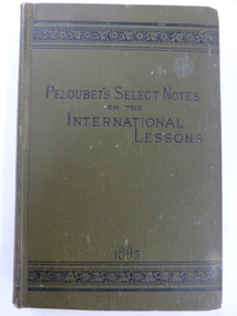
Book, Peloubet's Select notes 1895. 1898. 1904, 1895, 1898, 1904
These are three volumes of Peloubet’s Select Notes. The book contents are described as ‘Inductive, Suggestive, Explanatory, Illustrative, Doctrinal and Practical’. The books were issued as curriculum material for Sunday Schools and were first published in the mid 1870s and continued to be published for the next 100 years. These three volumes belonged to M. P. McMeekin and this is presumed to be Margaret Parker McMeekin (1868-1948), the daughter of John McMeekin and Isabella Parker of Warrnambool. John McMeekin was the Rate Collector and Inspector and then the Valuer for the Warrnambool Shire in the 1860s, 70s and 80s. Two sons, William and James, operated a produce export business in Kepler Street under the name of McMeekin Brothers and another son, Charles was an auctioneer in Warrnambool. It is surmised that Margaret McMeekin was a Sunday School teacher either in Warrnambool or Port Fairy. These books are of interest as examples of what was taught in Sunday Schools in the late 19th and early 20th centuries. They are also of interest because they belonged to Margaret McMeekin, a member of a prominent family in Warrnambool at that time. These are three books of a religious nature written by F. and M. Peloubet and published in 1895, 1898 and 1904. .1 A hard cover book of 346 pages with a greenish brown cover and gold lettering on the spine. Two blue stamps of the Warrnmbool & District Historical Society and a handwritten name are on the first page .2 A hard cover book of 344 pages with a brown cover and gold lettering on the spine. Two blue stamps of the Warrnambool & District Historical Society are on the first and last page. The cover has worn edges. .3 A hard cover book of 358 pages with a greenish brown cover and gold lettering on the spine. There are two blue stamps of the Warrnambool & District Historical Society on the first and last page. There is a black and white full page plate at the beginning of the book and this is protected by a piece of tissue. ‘M.P. McMeekin, Port Fairy’ (1895 volume) sunday schools, margaret mcmeekin, warrnambool history -
 Warrnambool and District Historical Society Inc.
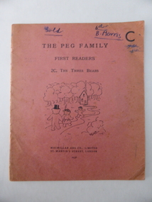
Book, The Peg Family First readers, 1936
... interest. Bruce Morris rates with Richard Osburne, Edward Vidler ...This is an early school reader and the name, ‘B. Morris’, suggests that it belonged to Bruce Morris, the editor of the Warrnambool Standard newspaper from 1946 to 1968. Bruce Morris was prominent in Warrnambool as the writer of a great number of historical articles in the Warrnambool Standard and as a passionate supporter of regional Victoria. He was the son of Frederick and Sarah Morris and the grandson of George Lance, prominent in 19th century Warrnambool as a plumber, inventor, musician, artist and writer. Lance is regarded as the founder of the Warrnambool Art Gallery. Bruce Morris helped to establish the Warrnambool Rostrum Club. This book is of interest because it is an early 20th century example of a school reading book. If it belonged to Bruce Morris then it is of greater interest. Bruce Morris rates with Richard Osburne, Edward Vidler and Henri Worland as a significant promoter of, and writer on, Warrnambool’s history. This is a soft cover book of 16 pages. It has a pinkish-red cover with a black and white illustration of The Three Bears story on the front cover and the titles in black print. The back cover has advertisements for other books by the same publisher (Macmillan and Co.). The inscription and some other writing on the front cover are handwritten in blue ink. The cover is a little faded and has partly come away from the pages. ‘B.Morris’ bruce morris, history of warrnambool -
 Warrnambool and District Historical Society Inc.
Administrative record - Town of Warrnambool Ledgers, Thomas Beattie, Warrnambool Rate Collector, early 20th century
These are two administrative record books from the Warrnambool Town Council which took over from the Warrnambool Borough Council in 1883 and existed until 1918 when it became the Warrnambool City Council. .1 Warrnambool Town Council letter book dating from 1904 to 1918 containing copies of letters written by the Rate Collector, Thomas Beattie .2 Warrnambool Town Council Contract Book dating from 1902 to 1909. The contract details include the name of the supplier or tradesman and the costs. Some of the contracts deal with the Corporation Baths, the Botanic Gardens and town tree planting. These record books are of historic interest as they include many projects in Warrnambool and the names of local people from early in the 20th centuryThese are two administrative record books from the Town of Warrnambool Council. .1 Letter Book with a blue cover and a pasted label and a brown leather spine and leather edging on the corners. The pages include an alphabetical index at the front of the book. .2 Ledger with a dark green cover and leather binding on the spine and the edges of the cover. The spine has red and brown leather labelsTown Of Warrnambool Contract Bookwarrnambool town council, thomas beattie warrnambool rate collector -
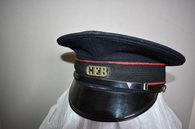 Warrnambool and District Historical Society Inc.
Country Fire Brigade Hat, Commonwealth Government Clothing Factory, Mid 20th century
This hat was part of the uniform of the Country Fire Brigade. The organization now known as the Country Fire Authority was established in 1945 as a volunteer and community-based organization providing fire fighting and emergency services in regional and rural areas in Victoria. Today the organization includes career fire-fighters and funding is partly provided by a levy included in local Council rates. The owner of this hat is not known. This hat is of minor interest and is retained for display purposesThis is a hat with a circular flat crown made of black felt with 4 eyelets. Around the edge of the crown is a brown leather band with a fabric bow fastening and a black cloth ribbon with a red corded edging. In the centre is a brass badge with letters on it. The peak is made of patent leather with a black leather band on the upper edge with metal buttons. The inside of the peak is made of green leather. Inside the hat is a plastic covering with a leather band. There is a cloth label with yellow printing. Commonwealth Government Clothing Factory Melbourne 7 C.F.B. country fire fighting services warrnambool, history of warrnambool -
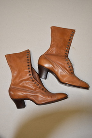 Warrnambool and District Historical Society Inc.
H. Perry & Co, Brown lace up boots x 2, 1906
These boots may have been made as a sample as they are a very small size and do not appear to have been worn. They come from the New Zealand International Exhibition held at Hagley Park, Christchurch from November 1906 to April 1907. This exhibition was the brainchild of the New Zealand Prime Minister, Richard Seddon who died before the exhibition opened. Nearly 2 million people visited the exhibition at a time when the population of New Zealand was less than one million. The exhibition was thus rated a success even though there was a financial loss. No information has been found on the bootmakers, H. Perry & Co. In the 19th and early 20th centuries boots were an essential item for women who often had to walk through unmade streets and muddy paddocks. This item is of interest as it is a memento of an important New Zealand Exhibition early in the 20th century. This is a pair of a lady’s light brown leather boots. The boots have long leather tongues with 16 eyelets either side to lace up the front instep. The laces are missing. The wooden heels are slightly raised. H. Perry & Co. New Zealand International Exhibition Christchurch 1906-7 vintage footwear, christchurch new zealand exhibition, 1906-7 -
 Warrnambool and District Historical Society Inc.
Newspaper - The Argus, The Argus Melbourne, 1925
This paper contains mostly news items and advertisements of the day. However some items contained within are fictional in nature.This is an original Argus in a maroon leather folder. The paper itself is a 32 page broadsheet which slides inside the folder for protection. A certificate of authenticity is glued to the inside cover of the folder.non-fictionThis paper contains mostly news items and advertisements of the day. However some items contained within are fictional in nature.warrnambool, the argus 1925, winslow, o'keefe, o'keeffe -
 Glen Eira Historical Society
Article - Howitt Family
Photocopied extract on ‘The Howitt Family of Barragunda’ from ‘Early Pioneer Families of Victoria and Riverina’ includes black photos of family. Handwritten family tree – source unknown. Two handwritten foolscap sheets with extracts from Caulfield Rate Books, 1857-1891 where Howitt is listed as owner of properties, records tenants, addresses, size of property and value. Typewritten notes on the biography of Dr. Godfrey Howitt, outlines qualifications, endowments, interest, membership, no map included – it says Foot Survey Map. Howitt, Alfred William, typed and handwritten notes, references to house. Notes on publications written by Howitts, and the roles they undertook.bakewell, millman william, howitt godfrey dr., howitt john henry, howitt richard, howitt phoebe, mrs. nee godfrey bakwell, howitt william, howitt edward, howitt charles ernest, howitt edith mary, howitt alfred william, burke and wills expedition, king john, ‘rosemont’ kooyong rd, melbourne university, pioneer, botanist, naturalist, squatters, doctors, crotonhurst rd, caulfield, kooyong rd west, balaclava rd west, eyre rd, hume rd, howitt thomas, tantum phoebe, boothby benjamin judge, botham mary, millman william, mcwilliams robert, blake arthur palmer, grice james, spretchley edward, mcnaughton goerge, campbell john a., serle w.h., howitt mary, mickle royal society of victoria, st. mary’s church of england caulfield, stables, slab huts, police magistrate, authors -
 Glen Eira Historical Society
Document - Reeves, Walter
2 items, which may be related, about old Elsternwick: 1/A roneod copy of Recollections of Walter Reeves: gives notes on local identities, their business’, Caulfield State School, places of interest and events that took place in the area; undated and apparently summarised by an un-named other person from Mr Reeves' recollections. 2/A hand written list taken from Rate Books 1864 of areas in dispute, including nine names of residents, between Caulfield and St Kilda, date and author unknown. No direct connection to Walter Reeves apparent but they are taped together.automobile, hebenstreit mr, shoobra road, butcher, glenhuntly road, henderson h mr, davis charles, hardware store, beddoe frank, horne street, shops, renown theatre, phoebe theatre, theatres, lepage phoebe, lepage jack, taylor ‘squizzie’, echuca terrace, edward street, hawthorn road, revees walter, dunn bros, cycle shop, cox bros, supermarkets, apps (undertakers), elsternwick men’s club, elsternwick trades club, johnston t., hayter george (painter and decorator), sargood frederick, cabmen, cabs, ‘ripponlea’, wilson dick, blacksmiths, orrong road, moran and cato, repco, downshire road, bullock (grocer), grocers, taylor’s liquor and wine saloon, bottleshops, biddle misses, schools, bliss mr, station master, elsternwick, bensonino mr, newsagents, caulfield, gas supply, point nepean road, rowney dick, trams, riddell’s paddock, football golf links, riddell john carre, rowan road, sports grounds, melville’s supermarket -
 Eltham District Historical Society Inc
Photograph, Frank Stokes with daughters Dorothy (left) and Beryl (right) at Stokes Orchard, Nyora Road, Eltham, 1944, 1944
Frank Stokes first traveled to the district by train in 1944 to find land with the intention to establish an orchard. By chance he met Arthur Bird of Bird Orchard (bounded by Pitt Street, Eucalyptus Road and Wattle Grove) and they got talking over their common interest. Arthur put Frank up for the night and pointed out the land, part of Crown Allotment 15, Section 5, Parish of Nillumbik (CA15) somewhat diagonally opposite Bird Orchard. Frank bought the land and for the next two years would travel by train from Melbourne to Eltham every weekend establishing Stokes Orchard and building a home for his family, which they eventually moved into in 1946. In the mid 1970s the Shire of Eltham divided the orchard up into numerous rate-able parcel lots, which became affordable for Frank. As a consequence Stokes Orchard was turned into a housing development by Macquarie Builders and marketed as the Stokes Orchard Estate in two stages; Stage 1 encompassing Scarlet Ash Court, Ironbark Close and Peppermint Grove bounded by Nyora and Eucalyptus roads c.1976 and Stage 2 encompassing Stokes Place, Orchard Way, The Crest and The Lookout bound by Nyora and Diosma roads c.1979. The development of Orchard Way, The Crest and The Lookout did not proceed as planned due to the lack of the sewer along Diosma Road and so many of the proposed lots were incorporated into five-acre parcels instead.Representative of the orchard growing areas of ElthamDigital file only - Digitised by EDHS from a scrapbook (containing commercially printed photos of digital scans) on loan from Beryl Bradbury (nee Stokes), daughter of Frank Stokes.1944, beryl bradbury (nee stokes), beryl bradbury (nee stokes) collection, dorothy stokes, eltham, frank stokes, nyora road, stokes orchard -
 Eltham District Historical Society Inc
Photograph, Frank Stokes with his mother Florence (nee West) and children, Dorothy (left), David (centre) and Beryl (right), Stokes Orchard, Nyora Road, Eltham, c.1950, 1950c
Frank's mother Florence was visiting from England at the time. Frank Stokes first traveled to the district by train in 1944 to find land with the intention to establish an orchard. By chance he met Arthur Bird of Bird Orchard (bounded by Pitt Street, Eucalyptus Road and Wattle Grove) and they got talking over their common interest. Arthur put Frank up for the night and pointed out the land, part of Crown Allotment 15, Section 5, Parish of Nillumbik (CA15) somewhat diagonally opposite Bird Orchard. Frank bought the land and for the next two years would travel by train from Melbourne to Eltham every weekend establishing Stokes Orchard and building a home for his family, which they eventually moved into in 1946. In the mid 1970s the Shire of Eltham divided the orchard up into numerous rate-able parcel lots, which became affordable for Frank. As a consequence Stokes Orchard was turned into a housing development by Macquarie Builders and marketed as the Stokes Orchard Estate in two stages; Stage 1 encompassing Scarlet Ash Court, Ironbark Close and Peppermint Grove bounded by Nyora and Eucalyptus roads c.1976 and Stage 2 encompassing Stokes Place, Orchard Way, The Crest and The Lookout bound by Nyora and Diosma roads c.1979. The development of Orchard Way, The Crest and The Lookout did not proceed as planned due to the lack of the sewer along Diosma Road and so many of the proposed lots were incorporated into five-acre parcels instead.Representative of the orchard growing areas of ElthamDigital file only - Digitised by EDHS from a scrapbook (containing commercially printed photos of digital scans) on loan from Beryl Bradbury (nee Stokes), daughter of Frank Stokes.1950, beryl bradbury (nee stokes), beryl bradbury (nee stokes) collection, david stokes, dorothy stokes, eltham, flatbed truck, florence stokes (nee west), frank stokes, nyora road, stokes orchard -
 Eltham District Historical Society Inc
Photograph, Stokes family, Nyora Road, Eltham, c.1952, 1952c
Taken from outside the family home on the southest corner of the intersection of Nyora Road and Pitt Street with Eucalyptus Road, looking northeast across the Stokes Orchard L-R: David, Howard, Beryl (kneeling), Dorothy and Gladys Stokes with Gladys's mother sitting in Gladys's father's car with Spot the dog, Nyora Road, Eltham, c.1952 Frank Stokes first traveled to the district by train in 1944 to find land with the intention to establish an orchard. By chance he met Arthur Bird of Bird Orchard (bounded by Pitt Street, Eucalyptus Road and Wattle Grove) and they got talking over their common interest. Arthur put Frank up for the night and pointed out the land, part of Crown Allotment 15, Section 5, Parish of Nillumbik (CA15) somewhat diagonally opposite Bird Orchard. Frank bought the land and for the next two years would travel by train from Melbourne to Eltham every weekend establishing Stokes Orchard and building a home for his family, which they eventually moved into in 1946. In the mid 1970s the Shire of Eltham divided the orchard up into numerous rate-able parcel lots, which became affordable for Frank. As a consequence Stokes Orchard was turned into a housing development by Macquarie Builders and marketed as the Stokes Orchard Estate in two stages; Stage 1 encompassing Scarlet Ash Court, Ironbark Close and Peppermint Grove bounded by Nyora and Eucalyptus roads c.1976 and Stage 2 encompassing Stokes Place, Orchard Way, The Crest and The Lookout bound by Nyora and Diosma roads c.1979. The development of Orchard Way, The Crest and The Lookout did not proceed as planned due to the lack of the sewer along Diosma Road and so many of the proposed lots were incorporated into five-acre parcels instead.Representative of the orchard growing areas of ElthamDigital file only - Digitised by EDHS from a scrapbook (containing commercially printed photos of digital scans) on loan from Beryl Bradbury (nee Stokes), daughter of Frank Stokes.1948-1951 vauxhall velox, 1948-1951 vauxhall wyvern, 1952, beryl bradbury (nee stokes), beryl bradbury (nee stokes) collection, david stokes, dorothy stokes, eltham, gladys stokes, nyora road, spot (dog), stokes orchard -
 Eltham District Historical Society Inc
Photograph, Stokes family with horse and sled, Nyora Road, Eltham, c.1950, 1950c
Taken from outside the family home on the southest corner of the intersection of Nyora Road and Pitt Street with Eucalyptus Road, looking northeast across the Stokes Orchard Frank Stokes with children, Dorothy (left), Beryl and David Frank Stokes first traveled to the district by train in 1944 to find land with the intention to establish an orchard. By chance he met Arthur Bird of Bird Orchard (bounded by Pitt Street, Eucalyptus Road and Wattle Grove) and they got talking over their common interest. Arthur put Frank up for the night and pointed out the land, part of Crown Allotment 15, Section 5, Parish of Nillumbik (CA15) somewhat diagonally opposite Bird Orchard. Frank bought the land and for the next two years would travel by train from Melbourne to Eltham every weekend establishing Stokes Orchard and building a home for his family, which they eventually moved into in 1946. In the mid 1970s the Shire of Eltham divided the orchard up into numerous rate-able parcel lots, which became affordable for Frank. As a consequence Stokes Orchard was turned into a housing development by Macquarie Builders and marketed as the Stokes Orchard Estate in two stages; Stage 1 encompassing Scarlet Ash Court, Ironbark Close and Peppermint Grove bounded by Nyora and Eucalyptus roads c.1976 and Stage 2 encompassing Stokes Place, Orchard Way, The Crest and The Lookout bound by Nyora and Diosma roads c.1979. The development of Orchard Way, The Crest and The Lookout did not proceed as planned due to the lack of the sewer along Diosma Road and so many of the proposed lots were incorporated into five-acre parcels instead.Representative of the orchard growing areas of ElthamDigital file only - Digitised by EDHS from a scrapbook (containing commercially printed photos of digital scans) on loan from Beryl Bradbury (nee Stokes), daughter of Frank Stokes.1950, beryl bradbury (nee stokes), beryl bradbury (nee stokes) collection, david stokes, dorothy stokes, eltham, frank stokes, horse, nyora road, sled, stokes orchard -
 Eltham District Historical Society Inc
Photograph, The Stokes family home blanketed with snow, corner Nyora and Eucalyptus roads, Eltham, winter 1951, 1951
Taken from outside the family home on the southest corner of the intersection of Nyora Road and Pitt Street with Eucalyptus Road. Frank Stokes first traveled to the district by train in 1944 to find land with the intention to establish an orchard. By chance he met Arthur Bird of Bird Orchard (bounded by Pitt Street, Eucalyptus Road and Wattle Grove) and they got talking over their common interest. Arthur put Frank up for the night and pointed out the land, part of Crown Allotment 15, Section 5, Parish of Nillumbik (CA15) somewhat diagonally opposite Bird Orchard. Frank bought the land and for the next two years would travel by train from Melbourne to Eltham every weekend establishing Stokes Orchard and building a home for his family, which they eventually moved into in 1946. In the mid 1970s the Shire of Eltham divided the orchard up into numerous rate-able parcel lots, which became affordable for Frank. As a consequence Stokes Orchard was turned into a housing development by Macquarie Builders and marketed as the Stokes Orchard Estate in two stages; Stage 1 encompassing Scarlet Ash Court, Ironbark Close and Peppermint Grove bounded by Nyora and Eucalyptus roads c.1976 and Stage 2 encompassing Stokes Place, Orchard Way, The Crest and The Lookout bound by Nyora and Diosma roads c.1979. The development of Orchard Way, The Crest and The Lookout did not proceed as planned due to the lack of the sewer along Diosma Road and so many of the proposed lots were incorporated into five-acre parcels instead.Representative of the orchard growing areas of Eltham. One of the rare times it has snowed in ElthamDigital file only - Digitised by EDHS from a scrapbook (containing commercially printed photos of digital scans) on loan from Beryl Bradbury (nee Stokes), daughter of Frank Stokes.1951, beryl bradbury (nee stokes) collection, eltham, eucalyptus road, nyora road, snow, stokes family home -
 Eltham District Historical Society Inc
Photograph, The first houses in construction on the new Stokes Orchard Estate, July 1976, July 1976
Viewed from near the Stokes family home at 1 Nyora Road looking northeast across Ironbark Close to Scarlet Ash Court with Peppermint Grove in the distance. Frank Stokes first traveled to the district by train in 1944 to find land with the intention to establish an orchard. By chance he met Arthur Bird of Bird Orchard (bounded by Pitt Street, Eucalyptus Road and Wattle Grove) and they got talking over their common interest. Arthur put Frank up for the night and pointed out the land, part of Crown Allotment 15, Section 5, Parish of Nillumbik (CA15) somewhat diagonally opposite Bird Orchard. Frank bought the land and for the next two years would travel by train from Melbourne to Eltham every weekend establishing Stokes Orchard and building a home for his family, which they eventually moved into in 1946. In the mid 1970s the Shire of Eltham divided the orchard up into numerous rate-able parcel lots, which became affordable for Frank. As a consequence Stokes Orchard was turned into a housing development by Macquarie Builders and marketed as the Stokes Orchard Estate in two stages; Stage 1 encompassing Scarlet Ash Court, Ironbark Close and Peppermint Grove bounded by Nyora and Eucalyptus roads c.1976 and Stage 2 encompassing Stokes Place, Orchard Way, The Crest and The Lookout bound by Nyora and Diosma roads c.1979. The development of Orchard Way, The Crest and The Lookout did not proceed as planned due to the lack of the sewer along Diosma Road and so many of the proposed lots were incorporated into five-acre parcels instead.Housing development in Eltham as an extension to the Woodridge EstateDigital file only - Digitised by EDHS from a scrapbook (containing commercially printed photos of digital scans) on loan from Beryl Bradbury (nee Stokes), daughter of Frank Stokes.1976-07, beryl bradbury (nee stokes) collection, building construction, ironbark close, nyora road, peppermint grove, scarlet ash court, stokes orchard estate, houses -
 Eltham District Historical Society Inc
Photograph, Looking south towards Nyora Road, Eltham, 1977, 1977
Viewed from near the end of Stokes Place where the linear reserve now runs between 8 and 9 Stokes Place just visible through trees in foreground, 24 Nyora with red roof is the first house in middle of view. Frank Stokes first traveled to the district by train in 1944 to find land with the intention to establish an orchard. By chance he met Arthur Bird of Bird Orchard (bounded by Pitt Street, Eucalyptus Road and Wattle Grove) and they got talking over their common interest. Arthur put Frank up for the night and pointed out the land, part of Crown Allotment 15, Section 5, Parish of Nillumbik (CA15) somewhat diagonally opposite Bird Orchard. Frank bought the land and for the next two years would travel by train from Melbourne to Eltham every weekend establishing Stokes Orchard and building a home for his family, which they eventually moved into in 1946. In the mid 1970s the Shire of Eltham divided the orchard up into numerous rate-able parcel lots, which became affordable for Frank. As a consequence Stokes Orchard was turned into a housing development by Macquarie Builders and marketed as the Stokes Orchard Estate in two stages; Stage 1 encompassing Scarlet Ash Court, Ironbark Close and Peppermint Grove bounded by Nyora and Eucalyptus roads c.1976 and Stage 2 encompassing Stokes Place, Orchard Way, The Crest and The Lookout bound by Nyora and Diosma roads c.1979. The development of Orchard Way, The Crest and The Lookout did not proceed as planned due to the lack of the sewer along Diosma Road and so many of the proposed lots were incorporated into five-acre parcels instead.Housing development in Eltham as an extension to the Woodridge EstateDigital file only - Digitised by EDHS from a scrapbook (containing commercially printed photos of digital scans) on loan from Beryl Bradbury (nee Stokes), daughter of Frank Stokes.1977, beryl bradbury (nee stokes) collection, nyora road, stokes orchard estate, stokes place -
 Eltham District Historical Society Inc
Photograph, Stokes Place, Eltham, July 1977, July 1977
Viewed from near the end of Stokes Place where the linear reserve now runs between 8 and 9 Stokes Place looking slightly east of south towards Nyora Road. The new Christian Church on Nyora now the Baptist Church visible in middle view. Frank Stokes first traveled to the district by train in 1944 to find land with the intention to establish an orchard. By chance he met Arthur Bird of Bird Orchard (bounded by Pitt Street, Eucalyptus Road and Wattle Grove) and they got talking over their common interest. Arthur put Frank up for the night and pointed out the land, part of Crown Allotment 15, Section 5, Parish of Nillumbik (CA15) somewhat diagonally opposite Bird Orchard. Frank bought the land and for the next two years would travel by train from Melbourne to Eltham every weekend establishing Stokes Orchard and building a home for his family, which they eventually moved into in 1946. In the mid 1970s the Shire of Eltham divided the orchard up into numerous rate-able parcel lots, which became affordable for Frank. As a consequence Stokes Orchard was turned into a housing development by Macquarie Builders and marketed as the Stokes Orchard Estate in two stages; Stage 1 encompassing Scarlet Ash Court, Ironbark Close and Peppermint Grove bounded by Nyora and Eucalyptus roads c.1976 and Stage 2 encompassing Stokes Place, Orchard Way, The Crest and The Lookout bound by Nyora and Diosma roads c.1979. The development of Orchard Way, The Crest and The Lookout did not proceed as planned due to the lack of the sewer along Diosma Road and so many of the proposed lots were incorporated into five-acre parcels instead.Housing development in Eltham as an extension to the Woodridge EstateDigital file only - Digitised by EDHS from a scrapbook (containing commercially printed photos of digital scans) on loan from Beryl Bradbury (nee Stokes), daughter of Frank Stokes.1977-07, beryl bradbury (nee stokes) collection, eltham, eltham christian church, stokes orchard estate, stokes place -
 Kiewa Valley Historical Society
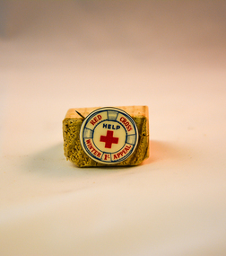
Badge Red Cross, circa 1968
... consequences (high interest rates, slowdown in Australian manufacturing ...When this winter appeal badge was produced the Australian economy was in recession (financial down turn) and the ability of some of the unemployed sectors of the community required but could not purchase warm clothes. The Australian recessions of 1945 and 1961 left their mark on the economy and accounted for a long and slow recovery in the 1960's and 1970's. The Red Cross was one of a few benevolent agencies/organisations that provided those more affluent in society to donate money to these types of appeals for financial donations. the money collected was used in obtaining warm close for those in need.In the Kiewa Valley the lingering recessional consequences (high interest rates, slowdown in Australian manufacturing) had an effect upon those whose produce was consumed by large towns and cities. The manufacturing industries including textile and clothing industries were feeling the start of the invasion of cheaper imports. Unemployment was beginning to be an ongoing major political and social issue. The need for support for the financial strapped city and country towns was on the increase and this Red Cross Badge (Winter Appeal) was one of several appeals to help those financially disenfranchised families to overcome the severe clothing shortages in both country and city environments.This badge has an enamel front with red and blue lettering and the circumference is marked to represent a 'life ring, life buoy, life belt' which has all of the red lettering with in its boundary. The fastening mechanism is a "stick" pin made from mild steel (fashioned as a semi circular spring contained within the back rim of the badge. The "stick" protrudes beyond the badge allowing it to be fastened onto clothing.At the top of the badge and in red print "RED CROSS" and at the bottom "WINTER APPEAL" with a"1/-" (one shilling coin - modern equivalent to 10 cents). In the middle of the badge is printed a red cross and above that "HELP"societies, red cross appeals, apparel badges, numismatics badges -
 Warrnambool and District Historical Society Inc.
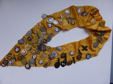
Trophies, Medal neck band, 1960's
The Marching girls activity was prominent in the 1960's and 1970's and had participation rate of around 30000. It was a part of activities such as street parades and town celebrations and local shows. However the girls also competed against other clubs . In this case the badges tell the story of competitions around the district to Ararat, Horsham, Ballarat, Beaufort and Warrnambool. These were owned by Lyn Bristol who was a member of the Warrnambool group. Most clubs had teams in various age groups. A tangible link to a local sport and club in the Warrnambool area. With large numbers of girls participating in the sport it has strong social interest .Yellow satin ribbon sewn to make a V shape rounded at the top. There are approximately 60 badges pinned to the ribbon which relate to marching events . They vary from coloured enamel to plain white and yellow metal . Some have bars at the top and they are engraved on the backs of the badges. The engravings list the different categories of marching girls competitions A number of them have the initials L B on them. They relate to the period of the early to mid 1960's.warrnambool, marching girls, marching girls warrnambool -
 Warrnambool and District Historical Society Inc.
Booklet, Victorian Almanacs, 1860s
These Victorian Almanacs were published from 1859 to 1916. They contained information of interest to all Victorians, especially historians, businessmen, farmers and gardeners and must have sold many copies in Warrnambool, particularly before the local Warrnambool Standard Almanacs began publication in 1875. These booklets are of interest as examples of 19th century almanacs published in Victoria. They are also somewhat similar to the Almanacs published annually by the Warrnambool Standard newspaper from 1875 to 1930. The 1869 Almanac is of particular interest as it has on the front cover the printed name of James Hider, stationer and bookseller of Warrnambool. James Hider had been a carpenter, a land agent and a rate collector before opening a shop in Timor Street, selling books and stationery and operating a Circulating Library. In 1865 Hider set up as a photographer and was still operating this business in 1878. He was active in community organizations, including the Mechanics Institute, the Fire Brigade, the National School, the Musical Group and the Benevolent Society. He was also a Councillor and a Mayor in the 1860s. It is interesting to note that his name does not appear to have been been added to the 1869 Almanac cover but is part of the original printing. These are two soft cover booklets of 60 pages each. The back covers of both are missing and the 1868 booklet has some back pages missing. The 1868 Almanac has a black and white cover with ornamental scrolls and the 1869 booklet has a red, green black and cream cover with an ornamental border and images of flora and fauna. The 1869 Almanac cover has a Coat of Arms with Advance Australia printed at the bottom of it. The 1869 Almanac also has a map of Victoria as an insert. Both almanacs contain an historical calendar, Victorian Parliamentary information, data on Victorian cities, postal regulations, farmers’ and gardeners’ guides etc. Both contain advertisements relevant to Melbourne. Both have been bound with string. victorian almanacs, annual journals, james hider, bookseller and stationer,, warrnambool. -
 Warrnambool and District Historical Society Inc.
Book, Book Holy Bible, 19th century
This Bible was owned by Janet Hose (nee Murfitt) 1856-1947. She was married to George Hose and they lived in Warrnambool for all of their married life. They had eleven children and all the births and some of the deaths of the children are recorded in this little Bible. The book was purchased from James Hider who had been a carpenter, a land agent and a rate collector before he established a bookstore in Timor Street in the 1860s. He was heavily involved in community affairs, being a local Councillor and Mayor in 1868-9. He was also an early commercial photographer in Warrnambool. This small Bible is of great interest because of its connection to the Hose family in Warrnambool. In the book are recorded the births and deaths of members of the Hose family. It was a common custom in the 19th century to include family history details in family Bibles and some larger-style Bibles had pages specifically printed to include family history material. This Bible is also of antiquarian interest, an attractive item with its leather cover and gold clasp.This is a mottled brown leather-covered Bible of 840 pages. The pages are gilt-edged and there is a gold metal clasp to close over the pages. Inside the front and back pages there are signatures and other handwritten material, some written in black ink and some in pencil. There is also a label from the Warrnambool book shop and stationery store of James Hider. The inscription pages and the front cover are stained. The cover is also rubbed. ‘J.Hider Opposite the Post Office Warrnambool’ ‘Janet Hose 19/07, 78,83 (Plus the family history details of the Hose Family, mostly on the back pages) janet and george hose, history of warrnambool -
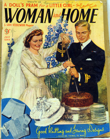 Orbost & District Historical Society
magazine, Woman and Home July 1944, July 1944
This magazine belonged to Roma Cameron, who was the daughter of Harry Purchase Cameron and Lilian Gladys (nee Harding). Roma married Ronald Richard Smith in 1944 and is the mother of Lorraine (Mrs Peter Coulton) and Margaret Smith. Harry's father, James Cameron, came to Bellagoogan on Majors Creek in 1882. Bellagoogan was on Majors Creek near Orbost and was the site of the first race course. Like many others at the time, the Camerons bred race horses.Harry died in 1964 aged 75. Roma was the youngest of three siblings: Jean (Mrs John Gavin (Jack) Ralston) and James (Jim) (m. Joan Hossack). Women’s magazines during WWII played a “reflecting role,” meaning they cooperated with government agendas while still including topics of readers’ interests Women’s employment rate had skyrocketed during WWII. However, even though the number of women working outside the home grew rapidly most of them were still engaged entirely in homemaking. Therefore women’s magazines centered mostly on the stresses and shortages of wartime. Articles as well as advertisements presented information on “product rationing, tips on keeping the family healthy, guidelines for thrifty shopping and advice on how to look good through it all. This is an example of an English women's magazine published during WW11.It gives practical advice on needlework / knitting and evidences the widespread interest in contemporary fashion. In doing so it shows what were the fashionable, but broadly affordable, women's and children's clothing styles of their day. These magazines also reflect women's interests An English magazine published monthly. It is titled Woman and Home & Good Needlework Magazine, July 1944. On the front cover is a picture of a bride and groom cutting a wedding cake. The groom is dressed in military uniform. the price 9D has been crossed out and 1/- is below it. The magazine contains advertisements, stories, needlework patters and news articles.On front cover handwritten in pen : Miss R. Cameronmagazine-woman-and-home magazines-women's cameron -
 Marysville & District Historical Society
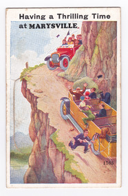
Postcard (item) - Novelty postcard, Valentine Publishing Co. Pty. Ltd, Having a Thrilling Time at Marysville, 1940's-1960's
A novelty postcard with pull-out strip of 11 miniature photographs that was produced by the Valentine Publishing Co as a souvenir of Marysville.A novelty postcard with pull-out strip of 11 miniature photographs that was produced by the Valentine Publishing Co as a souvenir of Marysville.Having a Thrilling Time/ at MARYSVILLE 1765 PRINTED PAPER/ MAILING NOVELTY/ SHAPE PASSED BY THE G.P.O./ FOR PRINTED PAPER POSTAGE RATE/ Only Name and Address of Sender Allowed/ If any other writing, Letter Postage is required/ TO OPEN RAISE FLAP From VALENTINE'S "MAIL NOVELTY" POST CARD. COPYRIGHT Printed in Great Britain Shape Passed/ by G.P.O./ for/ Printed Paper/ Postage Rate/ 34-2 Tomarysville, victoria, postcard, souvenir, valentine publishing co, acheron way (image 1), keppel's falls (image 2), cumberland falls (image 3), stevenson falls (image 4), mount margaret (image 5), main st (image 6), nicholl's lookout (image 7), the old ford (image 8), the acheron way (image 9), taggerty river (image 10), the road to cumberland valley (image 11) -
 Bendigo Historical Society Inc.
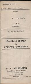
Document - H.A & S.R. WILKINSON COLLECTION: CONTRACT OF SALE
Conditions of sale by private sale dated 10th April, 1940 between W.V.O. Earl (seller) and C.M.F. Skilbeck (buyer) for land situate No.148 Booth Street, Bendigo, being the land described in right to occupy residence area No.4501. Also all the vendor's right, title and interest in that piece of land adjoining the above mentioned land described in permissive occupancy title no. W.52845, together with 5-roomed weatherboard dwelling and all sundry. Also bath, copper and troughs. Price 175 pounds. Attached 5 receipt issued by Department of Lands and Survey plus 2 receipt from City of Bendigo for rates. Vendor's copy.organization, business, h.a. & s.r wilkinson real estate