Showing 176 items
matching john storey
-
 Federation University Historical Collection
Book - Book - Scrapbook, Ballarat School of MInes: Scrapbook of Newspaper Cuttings, Book 65, October 1994 to November 1994
Collection of newspaper articles related to Ballarat School Of Mines.They cover activities and advertisements for staff. The papers concerned are The Courier, Ballarat, The Australian, The Age over the period of 24 October 1994 to 26 November 1994.Book with yellow cover, front, spiral bound. teaching positions advertised, pre-employment courses, courses available, enrolment for smb courses, minister storey inspects smb plans, eratica, vecci and smb join forces, apprenticeships at john valves, trade evening at ararat school of mines, garden for pleasure, top training team, ray schenk, margaret stewart, zivco miclch, ken gordon, city approve smb site, ceramics exhibit, ingrid van loon, barry norman, bryan rainford, on wild, neville french, david farnsworth, irene warfe, german group visit, great week for ballarat, literacy problems, rob newton, assist principal ararat secondary, ararat college and smb sign memorandum, skills training centre opening -
Federation University Historical Collection
Book - Book - Scrapbook, Ballarat Institute of Advanced Education: Scrapbook of newspaper cutting, Book 4, December 1970 to August 1971
Newspaper cuttings relating to Ballarat Institute of Advanced Education. These are from various newspapers and include The Age, Ballarat Courier, The Australian, The Herald. The cuttings cover the period from 12 December 1970 to 17 August 1971. Book with yellow cover, front. Spiral bound. Coloured card pasted on front cover. Front cover coming away.ballarat institute of advanced education, biae, employment advertisements, application for enrolment, outline of courses, engineers' conference, ballarat technical school, institute award to jim ryan, ken scull retires, first degree course at biae, $30000 x-ray unit for metallurgists, biae enrolments, equipment projects by physics students, no room for our potential residents, four new buildings planned for biae, john vernon's career, night school enrolments, apprenticeship commission visit, education first, festival diversity brings fun for all, enrolment taxes accommodation, overseas brewers have link with ballarat, vietnam a spur for student protest, mr g b fairhall, new student group formed, college diplomas "not recognised", smb "boat" on lake wendouree race, stock exchange award to danny dimmo, australia losing from student restrictions, first lecturer in brewing - n m gower, biae course encouraged, ph.d.for chemistry lecturer, smb exhibition of prints, impressive art by students, mining companies help education, christopher dower wins award for third time, bid to keep youths in country, students in two-storey units, smb registrar eric bald retires, master's degree to john duruz, a united approach?, fourth university probe group, university submission well received, wolfgang kotsch state's top aprentice, interest in twin-state uni, carol yates wins trust scholarship, student protest re fees increase, e c jone - architect, diplomas conferred, apprenticeship week display, $100 prize for wolfgang kotsch, bath run to daylesford, technical education - geoff storey, rex hollioake -
 Phillip Island and District Historical Society Inc.
Photograph, 1978/79
Findlay Art Gallery. The house was brought from French Island where it was the home of the De La Haye family.White timber house single storey. Findlay Art Gallery.local history, photographs, buildings, historic, buildings - historical, coloured photograph, john cook, phillip island, findlay art gallery -
 Phillip Island and District Historical Society Inc.
Photograph, 1978/79
Rhylstone Park in Thompson Avenue, Cowes, was the home of Mr Vaughan. Later run as a clock museum then a B & B until approx 2007.A brick house built by Mr Joseph Vaughan about 1890. It was named Rhylstone Park. single storey - bull nose verandah.local history, photographs, buildings, historic, buildings - historical, coloured photograph, john cook, phillip island -
 Phillip Island and District Historical Society Inc.
Photograph, 1978/79
The home of the Figuerola sisters. They were three artistic single ladies. In 1955 Carmen Figuerola published the little book "Family on Phillip Island" - a lovely story of the bland family. Today the house does not exist.Single storey old weatherboard house in Steele Street, Cowes. A lot of green shrubbery and trees.local history, photographs, historic, buildings - historical, coloured photograph, john cook, phillip island -
Glenelg Shire Council Cultural Collection
Souvenir - Tea Towel - Maretimo, Portland, n.d
From the National Trust register: Statement of Significance Maretimo, a 22 room single storey Australian Colonial Georgian style mansion set on a prominent bluff overlooking Portland harbour, was erected c. 1854 for John Norman McLeod. The design of Maretimo, which is constructed of basalt ashlar with fine-axed parapet entablature, delicate open timber work verandah and Regency interior, has been tenuously attributed to Adelaide architect James Barrow. Maretimo is rivalled only by the stylistically similar Henty residence, Burwsood of 1853 by James Barrow, as perhaps the finest Australian Colonial Georgian style residence erected within the first twenty years of settlement in Victoria. The residence, which was occupied for twenty years by distinguished English-born gentleman parliamentarian, pastoralist and former Van Deimen's Land settler, J H McLeod, is now notable for the disciplined facade and elegantly crafted interiors. Maretimo has been meticulously maintained and is presented in near perfect original condition. The interiors have been sensitively enhanced and redecorated.Linen souvenir tea towel 'Maretimo'. Green and black on cream. 'MARETIMO' at top, front view of Maretimo beneath, then map of locaion, then view from air. 'HISTORIC HOME PORTLAND, VICTORIA' beneath 'Pure Linen', bottom right.historic building, historic homestead, maretimo, henty, souvenir -
 Eltham District Historical Society Inc
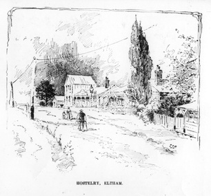
Photograph, The Australasian, Hostelry, Eltham, 2 May 1903
Looking south along Maria Street (now Main Road, Eltham) from the John Street intersection, showing the Evelyn Hotel with its two storey "Ball Room", the kerosene road lamp marks the intersection of Pitt and Maria streets. Cross Reference Photo No.(s): SEPP_0626 (Scarce House) The Scarce house can be seen to the right of the Hostelry.This photo forms part of a collection of photographs gathered by the Shire of Eltham for their centenary project book,"Pioneers and Painters: 100 years of the Shire of Eltham" by Alan Marshall (1971). The collection of over 500 images is held in partnership between Eltham District Historical Society and Yarra Plenty Regional Library (Eltham Library) and is now formally known as the 'The Shire of Eltham Pioneers Photograph Collection.' It is significant in being the first community sourced collection representing the places and people of the Shire's first one hundred years.Digital imagesepp, shire of eltham pioneers photograph collection, eltham, evelyn hotel, john street, main road, maria street, hostelry -
 Eltham District Historical Society Inc
Photograph, Class of 1922, Research State School No. 2959
The Children of Research State School in 1922 Photo and list of children provided by Ivy Reynolds to Ross McDonald. Ross has supplemented and filled in some blanks, from the children names in Andrew Lemons book 'Return to Research. A centenary of Research Primary School, 1989 ' page 103. Additional commentary provided by Ivy Reynolds in 2006. 1. Winnie La Frenz - a great friend of the Reynolds 2. Ruth Thompson - Wally Buttwell's niece 3. Bertha Wiltshire 4. Ivy Dickson (who grew up to be a good-looking woman) 5. May Norman - a cousin to the Reynolds through Ernest Reynolds 6. Elsie Shaw 7. Veenie Turner (Ivy was not 100% sure of her surname, but said she was not related to Hazel Turner) 8 Lil La Frenz (Lilian) - a bright spark and a lively tennis player 9 Lily Wilson (looks like a boy) - had red hair 10 Hazel Turner - a cousin of the Reynolds who lost her mother very early in life. Her father remarried and the family then became Roman Catholics, which in those days, caused them to become distant with the Anglican Reynolds family 11 Lila Dickson (Lyla) 12. Jack Wilson - a red-head like his sister 13. Len Blashick 14. Marjory Palmer 15 ? Burgoyne 16 Lance Doney and 17 Bill Doney. Cleaver boys who went to Ivanhoe Grammar. Both caught TB from their mother and died young. 17. Bill Doney - The Doneys were clever boys. They went to Ivanhoe Grammar after Research Primary and this educational advantage caused them to grow apart from the local boys. Both caught tuberculosis from their mother and didn't live long. Lance died first, but Bill survived long enough to join the Merchant Navy. He eventually entered the Mont Park Sanatorium where Ernest Reynolds used to visit him every Sunday. The Doney boys were keen on Margaret and Ivy Reynolds at one stage (probably before they became seriously ill) and Bill gave Ivy a macrame belt he'd made. 18 ? Burgoyne 19 ? Messen (Frank or Alex Masson) 20 Neville West 21 ? Shaw 22 ? Shaw 23 Neil Palmer 24 George Shaw or his brother Bertie 25 George Shaw or his brother Bertie 26 Eva Kilson 27 Lorna Turner 28 ? Henry Fox (or possibly Eric?) 29 Nancy Storey (adopted) 30 Mona Fox 31. Nell Storey (also adopted) She married Sam Howard and they had 2 daughters. One went to Queensland, the other lived locally and helped at the Research Anglican Church. 32 Victor Davey 33 Margaret Reynolds 34 Ethel Davey - cousin of the Reynolds through Ernest Reynolds 35 ? Randall (Freddie) 36 ? Randall (Kitty) -Their father was a builder who made toys for every child at the school one Christmas 37 Ronnie Turner 38 ? Ivy couldn't remember his name, but thought he lived at the Research Hotel 39 John Reynolds 40 Jim Davey 41 Unknown 42 Ivy Reynolds 43. Unknown - one of the unknown boys is Jimmy Storey 44. Unknown 45. Unknown 46. Dorothy La Frenz 47. Eric Fox 48. Unknown 49. Possibly Bert Shaw One of the boys in the photograph is Jimmy Storey The Reynolds family were early settlers in Research. The Reynolds/ Prior collection of photographs were taken by Tom Prior, the maternal uncle of Ivy Reynolds, around 1900 and the 60 photos in the album give a fine overview of many of the landmarks of Research and Eltham over 100 years ago. lvy lived in the family home for many years at 106 Thompson Cres Research. Ivy's father, Ernst Richard Reynolds and grandfather, Richard Reynolds, lived at the same address. Ivy's father Richard worked for Mr. Trail on his property in Research. Reynolds Road is named after the family. Mr Tom Prior (wife Eva) worked at the Melbourne zoo. He was very innovative and made his own camera, using the black cloth hood to exclude the light. The photographs are a reminder of the rural nature of Research and Eltham and its rich heritage. Black and white photograph mounted in an album, the Reynolds/Prior Photograph Collection, this being one of 53 reproduced black and white images of early Eltham.The Reynolds/Prior Photograph Collection, Presented to the Eltham District Historical Society, 14 June 2006 by Ross McDonald. A second copy was also presented to the Andrew Ross Museum, Kangaroo Groundreynolds prior collection, research (vic.), research school, schools, school children, state school no. 2959, winnie la frenz, ruth thompson, bertha wilshire, ivy dickson, may norman, elsie shaw, veenie, lil la frenz (lilian), lily wilson, hazel turner, lila dickson (lyla), jack wilson, len blashick, margery palmer, burgoyne, lance doney, bill doney, frank messen, alex masson, neville west, shaw, neil palmer, george shaw, bertie shaw, eva kilson, lorna turner, henry fox, eric fox, nancy storey, mona fox, nell storey, victor davey, margaret reynolds, ethel davey, freddie randall, kitty randall, ronnie turner, john reynolds, jim davey, ivy reynolds, dorothy la frenz, bert shaw, jimmy storey -
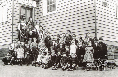
 Ringwood and District Historical Society
Photograph, Ringwood State School - Class photograph- Grade 3, 1937
... , Milton Gray, Gordon Storey, (?) Richards, Wally Vincent, John... - L to R: Des Trewitt, Milton Gray, Gordon Storey ...Black and white photograph - Grade 3, 1937"Attached to photograph" Back Row - L to R: Des Trewitt, Milton Gray, Gordon Storey, (?) Richards, Wally Vincent, John Jewkes. 2nd Row -- L to R: ?, ?, Bill Dellar, Ernie Goodall, Leon Brown, ?, ?, ?. 3rd Row - L to R: Kath Crouch, ?, ?, Dulcie Long, Lillian Wilson, Mollie Long, Dawn Sanders. 4th Row - L to R: Linda Washusen, ?, ?, Dorothy hancy ?, ?, ?. Front Row- L to R: Don Parker, ?, Len Leviston, ?, Jeff Roberts, ?, Graeme Clifton, Jack McKay. Teacher: -
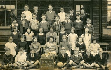
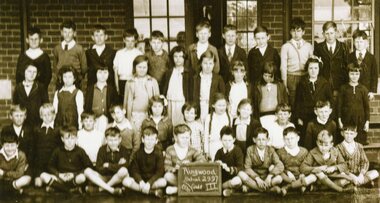 Ringwood and District Historical Society
Photograph, Ringwood State School - Class photograph- Grade 3, 1936
Black and white photograph - Grade 3, 1936"Attached to photograph" Back Row - L to R: ?, Doug Jackson, ?, Doug Tasker, Brian Skurry, ?, Wilfred Henman, John Godfrey, Lauri Divola, Gordon Storey, Ian Benson. 2nd Row -- L to R: ?, Peggy Wilkins, ?, ?, Charlotte Sorenson, Gloria Dell, Joan Murray, Beryl Lackman, ?, ?. 3rd Row - L to R: ?, Lyall Dickson, ?, Ken Foreman, Joyce Hall, Isabella Sorenson, ?, ?, Ivan Mayes, ?. Front Row- L to R: Fred Warren, ?, Lenny Dawson, ?, (?) Anderson, Lindsay Allen, George, Hampson, (?) Tortice. Teacher: -
 Glen Eira Historical Society
Album - Album page, Booran Road, 30, Circa 1972
This photograph is part of the Caulfield Historical Album 1972. This album was created in approximately 1972 as part of a project by the Caulfield Historical Society to assist in identifying buildings worthy of preservation. The album is related to a Survey the Caulfield Historical Society developed in collaboration with the National Trust of Australia (Victoria) and Caulfield City Council to identify historic buildings within the City of Caulfield that warranted the protection of a National Trust Classification. Principal photographer thought to be Trevor Hart, member of Caulfield Historical Society. Most photographs were taken between 1966-1972 with a small number of photographs being older and from unknown sources. All photographs are black and white except where stated, with 386 photographs over 198 pages. From Glen Eira Heritage Management Plan 1996 by Andrew Ward: In 1888, John Leek, a trainer, owned Lot 15, measuring one and three quarter acres, in Booran Road, north side between Glen Eira and Neerim Roads. The land backed onto the Caulfield Racecourse Reserve. NAV was £45. In 1890 Leek built for his residence, a ten roomed brick house on the site. NAV was £200. Leek was the owner/trainer of "Ingliston" who won the Caulfield Cup in 1900. Upon the horse's death in 1901, Leek is understood to have defied tradition by spending £20 on boots for the "ragged urchins in Bourke Street" instead of "shouting" at the bar. By 1899, the property was owned and occupied by Alfred Merrill, a dentist and was known as "Andover". NA V had decreased to £ll0. By 1910, Leslie Macdonald, a gentleman had purchased the property and renamed it "Moidart". In 1910-11 Macdonald sold it to John Robertson. The property had extensive wood stables on its north-east boundary and several other outbuildings. The house continued to be described as "Brick, ten rooms" as it was in 1926 when it was owned and occupied by John Arthur, a managing director. The land measured la.2r.31p. and had a NAV of £235. Nine people lived there. In 1926, Arthur also owned the adjoining Lot 16. Other racehorses of note, known to have been stabled here include Sobar, Havelock, Proud, Future and Lord.Victorian Heritage Register https://vhd.heritagecouncil.vic.gov.au/places/13532 What is significant? Lord Lodge is a thoroughbred racehorse training complex adjacent to Caulfield Racecourse, established in 1890. The area immediately around the racecourse has been associated with horse racing activities and businesses servicing the industry since the development of the racecourse in late the 19th century. Lord Lodge was named by the present occupants after the champion racehorse Lord who was stabled there in the 1950s. In the early 20th century the property was known as 'Andover' and subsequently 'Moidart'. The site consists of a single storey brick Italianate villa, jockeys' quarters, stables and open day yards with direct access to Caulfield racecourse from the rear of the property. The villa of 10 rooms on bluestone foundations was constructed in 1890 by John Leek, a horse trainer who purchased the newly subdivided land in 1888. The house has many Victorian Italianate or Boom Style features although it is more modest than many villas of its style. It has an asymmetrical facade with a faceted bay window and a prominent central tower with low pitch pyramidal roof that provides a clear view of the racecourse. Other characteristic features include stilted segmented arches, bracketed eaves, stucco wall finish and cast cement ornamentation. A room has been added on the north-facing verandah in sympathetic style and finish. Internally the rooms are substantially intact with original marble fireplaces and intricate ceiling roses and cornices. An entrance toward the rear of the southern side of the house is said to be where the stable hands, jockeys and other staff lined up for their meals. In the southeast corner of the property, backing directly on to Caulfield racecourse, is a substantial late Victorian timber stable, probably constructed in the 1890s but first appearing on the property title in 1910. The stable has 12 stalls, a loft and brick pavement and jerkin head roof form with varnished pine-lined ceiling carried on a chamfered timber frame. It has an original roof lantern. The doors of the stalls are not the original sliding doors but swing doors obtained from a barn at Epsom Racecourse in Mordialloc prior to demolition. Outside the gambrel roof has fretted barges but the building is otherwise utilitarian. Timber throughout the stalls has been worn by chewing and rubbing of horses over the century of its use. In the southern half of the property are open day yards where the racehorses are kept during the day. The red brick, single storey jockeys' quarters to the rear of the villa were probably built around 1950. A small brick, possibly late Victorian structure on the eastern boundary thought to have originally been a gardening shed, has been converted to a stable of two stalls. Modern concrete brick stables fill the northeast portion of the property. At the front of the property two Moreton Bay Figs (Ficus macrophylla), probably planted in the late 19th century, provide shade for horses in the day yards. In the 1890s John Leek sold the property, relocating his training facility to one of the newly established racecourses at Mentone or Mordialloc (Epsom). By 1899, the property was owned and occupied by Alfred Merrill, a dentist, who named the property 'Andover'. In 1910 it was purchased by Leslie McDonald, a gentleman, and renamed 'Moidart'; sold in 1910-1911 to John Robertson; and again in 1926 to John Arthur, a racehorse owner. The Victorian Amateur Turf Club purchased the property in the late 1930s and since this time has been leased to racehorse trainers. It is unclear whether the property operated as a training facility between 1899 - 1926. Several notable trainers and jockeys are associated with Lord Lodge. The best known is Arthur 'Scobie' Breasley, Australia's most successful jockey who was apprenticed to trainer Pat Quinlan at Lord Lodge (then 'Moidart') from 1928 - 1935. Breasley rode winners of the Caulfield Cup in four successive years 1942-45 and again in 1952. John Leek, the original owner of Lord Lodge trained Ingliston, the 1900 Caulfield Cup winner. Along with 'Lord' a number of well known racehorses including Sobar, Havelock, Proud and Future were trained at Lord Lodge .....Page 40 of Photograph Album with three landscape photographs of the exterior of this house.Handwritten: 30 Booran Road [top right hand corner] / 40 [bottom right]trevor hart, jenny o'donnell, booran road, mansion, caulfield east, ingliston, sobar, havelock, proud, future, lord, andover, moidart, lord lodge, grace darling, caulfield racecourse reserve, victorian amateur turf club, historic buildings register, national estate register, caulfield cup, horses, stables, horse racing, racehorses, outbuildings, racehorse trainers, depression, 1890s, brick houses, mansions, towers, verandahs, stained glass, italianate style, victorian style, architectural features, architectural styles, john leek, leslie macdonald, john arthur, john robertson, alfred merrill, jenny odonnell -
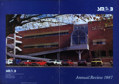 Federation University Historical Collection
Booklet - Annual Review, Ballarat School of Mines Annual Review, 1986 -1991
The Ballarat School of Mines was established in 1870 through the initiatives of the Ballarat Mining Board making it the oldest site of technical education in Australia. The Board was concerned with the shortage of mine managers for the goldfields. Classes began in surveying, mathematics, and chemistry and a decade later they included metallurgy , assaying and geology. With the decline in goldmining the direction of the college changed and broadened, the art School was established and the Ballarat Junior Technical School developed. In 1976, the tertiary sector seperated from the School of Mines and Industries Ballarat to form the Ballarat College of Advanced Education. In the 1980s SMB was a Community College of Technical Education and Further Education (TAFE) offering a wide range of vocational, enrichment and preparatory programs. It is continuing the tradition of providing for the educaiton needs of people within the Central Highlands. During the 1970s and 80s it acquired and refurbished old buildings and developed new facilities to keep up with the needs of an expanding curriculum and student population. The era of these annual reports is just before the merger with the University of Ballarat.A number of soft card covered annual report for the Ballarat School of Mines. .1) 12 page black covered report featuring an image of the E.J. Tippett Library. Includes information on death of E.J. Tippett, disability policy, Peter Quinn, Patti McNulty, Bob Feary, Shane Everand, Integration, Fiona Watson, retirement of Robert Morgan, Opening of the carpentry and Joinery Facility in Davey Street, formation of the School of Business and Information Technology, Melissa Bone, opening of the E.J. T. Tippett Learning Resource Centre (Library), Refurbishment of the Administration Building, Food Service Building (Prospects), Court House Theatre, Enrolment centre, Museum, Creche, Women's Trade technical Program, Rural Education Program, Ararat Prison Program, Community Studies Section, Ararat Adult Literacy Group. Literacy Assistance for Undergraduates, Fire training, fitness, open Learning, Training & Employment Group, Awards, Filipino Visitors, oil Seed Research, Brunei, Barometer (gift) for Horticulture, Special Equipment (guillotine and brake press; programmable logic Controller; theodolite: laser lever; Universal testing Machine; Atomic Absorption Spectrophotometer)., organisational Structure. Photos include Ken Flecknoe, Peter Quinn, Patti McNulty, Bob Feary, Shane Everard, Fiona Watson,Linda Bland, Robert Morgan, David McCaughey, E.J. Tippett, Frank Sheehan, Julie Baulch, Jo Reeves, Col McCurry, Jenny Garnham .3) Blue covered book with a photograph of the M.B. John Building taken from Albert Street on the cover. Topics include: Ken Flecknoe, Peter Shiells, Ararat Campus, David Haddow, Kevin Martin, Rendle Hannah, Gary Eason, Geoff Pope, Albert Peart, M.B. John building opened, Hairdressing Salon, Community Centre, Creche, closure of Lydiard Street, Museum, Jenny Levison, Inskill, Small Business Training, Ballarat Eat free Library, Barkly Street, Wormalds Valve Group, Aboriginal Programs, Horticulture Center, Awards, Country fire Authority, tractor Donation, Women's Policy. Special purchases included surveying equipment with data recorder, test rig , CDT MIG welder, compact gas chromatograph with FID and single pen recorder, Olivetti stand-alone word processing unit. Images include Ken Flecknoe. Peter Shiells, John Crowe, Trevor Slater, Brian McLennan, Kerrie Cross, Albert Peart, John Cain, M.B. John, Enrollment Centre, Museum, Jo Watson, Wormalds, Brian Webber, Dianna Nikelson, Ian Aitken, Brendan B, Chez Dichiera, Heather Dixon, Julie Broadbent .4) 1993 - Brown and white soft covered annual review featuring students of the Ballarat School of Mines at work. Bill Gribble, Brian McLennan, Peter Shiells Retirement, Robert C. Lovett, Steven Mendelson, Max Palmer, Jenny Gough, Mary Molloy, Barrie Firth, Colin McCurry, Dora Hormann, Organisation Structure, Brewery Acquisition, Humffray Street Primary School, Grant Street Retaining Wall, Neville Bunning Plaque, VCE Plus, Ballarat Small Business centre, Ararat Prison, Ballarat Showgrounds Rotunda, .6) Green covered annual review with an aerial photograph over Albert Street, Ballarat. Content include Kerrie Cross, Peter Shiells. Kenneth Flecknoe Obituary, Ian Pimblett, Keith Boast, David Nicholson, Max Palmer, Brian Webber, Bob Lovett, Linda Bland, Prospects, Training restaurant, 3BBB, Malcolm Vallance, Aboriginal Programs, Ian Cathie, Koorie Support Unit, Caroline Hogg, 'Trained Men Make Their Own Terms' exhibition at the Gold Museum, Ricky Hains, Stephen Hughes, Jeff White, Dennis Bolster .8) Blue covered review for 1989. The contents include: Kerrie Cross, Peter Shiells, Ann McCaffrey, Kevin Alsop, Mary Molloy, Ross Furness, Robert Lovett, Victoria Street Student Hostel, Hugh Beggs, Ballarat Small Business Centre, Inskill, Ararat Campus, Hospitality and Tourism, Koorie Support Unit, Fiona Warsn, Bruce Staley, Terry Moran, Anthony Wonish, Ivan Deveson, Leo Shannon Memorial Award, Bryan Crebbin, Geoff Howard, R.C.W. Burdett, Jeff White, Ian Harris, Tom Wiseman, Bill Gribble, Allison Kay, Steven Mendelson, Keith Boast. .9) Grey covered book with a coloured photo of the Victoria Street Student Residence. Contents include: Kerry Cross, Peter Shiells, Morgan Bevan John Illuminated address. Jean Phillips, Koorie Support Unit, Andrew Sullivan, Victoria Street Student Residence, Horticulture, Inskill, Tertiary Awareness Project, Adult Education, Ivan Deveson, Brian Howe, Barry Jones, Joan Kirner, Andrew Trigg, Warren Perry, Murrell Rock Collections, Gwyn Hanssen-Piggott, Disability Awareness Day, Sebastopol Borough Logo, Phoebe Rimmer, Russell Jackson, R.J. Young Scholarship, Peter Muir, Founders Day Cake, Morgan John. .11) Black card covered booklet with five images of exteriors of the Ballarat School of Mines. the contents include: Jack Barker, Peter Shiells, Peter Ellyard, Ian Stoney, Terry Moran, Wayne Strong, David Ince, Simone Titheridge, Ian Aitken,Kevin Alsop, Bill Bridges, Clive Carmichael, Bob Feary, Rendle hannah, Roly Parfenovics, Graham Snibson, Kevin Stockdale, Len Wilson, Child Care Centre opening, Student accommodation, Victoria Street, Brewery site. naming buildings, E.J. barker. A.W. Steane K.J. Flecknow, Carpentry and joinery, Inskill, Hospitality, Pottery, ceramics, Founders' Day, Warren Perry, Agreement between Ballarat School of Mines and Ballarat university College, merger, Peter Baldwin, Awards, obituary Lindsay Hillman. Images include: Wayne Strong, David Ince, Simone Titheridge, kerrie Cross, Joan Kirner, Frank Sheehan, Bill Gribble Ros Wilkie, Judi O'Loughlin, Tony Leonard, Gemma Hearnes, Brendan Hill, Joanne Bell, Karl Moon, Stella Savy, Shirley Falkinder, Peter Baldwin, Jack Barker, Michael Ronaldson, David Kemp, Peter Shiells, Margot Healey, Sharon McLennan, Kerrie Firns, Petrena Brookers, Deb Goudappel, Claire Bond, Administration Building Lindsay Hillman. .13 ) Brown covered report with photographic images. Content includes: Pam Merrett. , Peter Shiells, Robert Lovett, Steven Mendelson, Max Palmer, Jenny Gough, Barrie Firth .14) Brown covered report with photographic images. Content includes: .15) Green covered report with photographic images. The blond woman standing on the right looking at a computer screen is Pam Merrett. Content includes: Bill Gribble, Ron Wild, Doug Sarah, Martin Hill, John Kemp, David Manterfield, Leslie Comy, Linette Penhall, Glen Martland. Virginia Fenelon. Michael Bracher, Brewery Building. Child care centre, Prospects Cafe Opening, Horticulture Training Centre, Retaining Wall, The Gordon, University of Ballarat and Ballarat School of Mines affiliation, Geoffrey Blainey, Ararat Community College Memo of understanding, Brian McLennan. Founders Day (Hadden Storey), Gwyn Hanssen-Pigott, Ken Latta, Neville Bunning Outstanding Achievement Award, Valerie Wilson, Jack Barker, John Sharpham, Jack Barker Resignation.ballarat school of mines, university of ballarat, integration, shane everard, robery morgan, linda bland, ballarat junior technical school, former court house, ken flecknoe, bruce muir, lindsay hillman, neil crouch, jack barker, keith boast, rex hollioake, m.b. john, bob lovett, brian mclennan, peter shiells, bruce tanner, jeff white, bryan crebbin, kerrie cross, ric dunlop, tom wiseman, barbara hughes, chris matheson, morgan b. john, albert street, steven mendelson, john crowe, ann mccaffrey, kevin alsop, mary molloy, ross furness, robert lovett, victoria street student hostel, student residences, hugh beggs, ballarat small business centre, inskill, ararat campus, hospitality and tourism, koorie support unit, fiona watson, bruce staley, terry moran, anthony wonish, ivan deveson, leo shannon memorial award, geoff howard, r.c.w. burdett, ian harris, bill gribble, allison kay, liz eddy, pam merrett, doug sarah, martin hill, john kemp, david manterfield, leslie comy, linette penhall, glen martland, virginia fenelon, michael bracher, brewery building, child care centre, prospects cafe, horticulture training centre, retaining wall, the gordon, university of ballarat and ballarat school of mines affiliation, geoffrey blainey, ararat community college memo of understanding, founders day, hadden storey, gwyn hanssen-pigott, ken latta, neville bunning outstanding achievement award, valerie wilson, john sharpham, kerry cross, morgan bevan john illuminated address, jean phillips, andrew sullivan, victoria street student residence, horticulture, inskill, tertiary awareness project, adult education, brian howe, barry jones, joan kirner, andrew trigg, warren perry, murrell rock collections, gwyn hanssen-piggott, disability awareness day, sebastopol borough logo, phoebe rimmer, russell jackson, r.j. young scholarship, peter muir, kenneth flecknoe obituary, ian pimblett, david nicholson, brian webber, prospects, training restaurant, 3bbb, malcolm vallance, aboriginal programs, ian cathie, caroline hogg, 'trained men make their own terms' exhibition at the gold museum, ricky hains, stephen hughes, dennis bolster, aboriginal education, e.j. tippett obituary, patti mcnulty, bob feary, equal opportunity officer, robert c. morgan, school of business and information technology, e.j. tippett library, e.j. tippett library opening, carpentry and joinery, women's trade and technical program, rural education program, ararat prison program, barometer, oil seed research, . bill gribble, peter shiells retirement, robert c. lovett, max palmer, jenny gough, barrie firth, colin mccurry, dora hormann, organisation structure, brewery acquisition, humffray street primary school, grant street retaining wall, neville bunning plaque, vce plus, ararat prison, ballarat showgrounds rotunda -
 Federation University Historical Collection
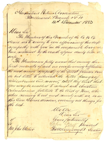
Correspondence, John Gray, Letter of Condolence from ANA to John Mateer. 1883, 14/12/1883
The Australian Natives Association (ANA) Benefit Society was formed in 1871 at a meeting of young men in Grimwood's Hotel, Elizabeth Street, Melbourne. The Association was one of many friendly societies that also aimed to promote the moral, social and intellectual advancement of its members. The young founders restricted membership to native-born Australians, but there were no Koories among them. The Australian Natives Association Ballarat Branch (No4) was founded in 1874. The association’s modest building was based in Camp Street and the branch was one of the most active in the colony, playing a key role in Federation. The Ballarat branch of the ANA was wound up in 1957 and the double storey building has since been used as for office space most recently for employment companies such as Tracey Recruitment. Ballarat's ANA Hall has heritage status under the City of Ballarat’s Camp Street heritage overlay HO186, however it is not listed by either the Victorian Heritage Register or the National Trust.Handwritten letter glued onto a lined page. The letter is from the Australian Natives Association Ballarat Branch No. 4, and is written to John Mateer at the time of his wife's death. The letter is signed by John Gray (President) and Fred Wainwright (secretary). Fred Wainwright was the first secretary of ANA branch No. 4. hew as a clerk at Ballarat Town Hall, and presented an essay on Federation of Australian Colonies in 1879.Australian Natives Association Ballaarat Branch No 4 14th December 1883. Dear Sir The members of this branch of the A.N.A. desire us to convey to you expression of their deep sympanth with you in the irreparable loss you have sustained by the death of your dearly beloved wife. The Members are fully aware that during the first month of such an overpowering infliction the most sincere sympathy of the truest friends can do little by alleviate the bitter pangs of remembrance and sorrow, still they trust that you may be enabled to submit with christian calmness and fortitude to the Will of Him, who, when seeming to act most severely wit us, is in His Own Divine Wisdom, ordering things for the best. We are Dear Sir Yours fraternally John Gray President fred Wainwright Secretary To Mr John Mateer australian natives' association, ana, ballarat branch no. 4. ballaarat branch no. 4, gray, john gray, wainwright, fred wainwright, mateer, john mateer -
 Federation University Historical Collection
Postcard - black and white, South Parade, Bath
South Parade in Bath, Somerset, England is a historic terrace built around 1743 by John Wood, the Elder.Black and white postcard showing South Parade Bath lined with triple storey buildings and trees. A lady posts a letter in the foreground of the image.chatham-holmes family collection, bath, south parade -
 Federation University Historical Collection
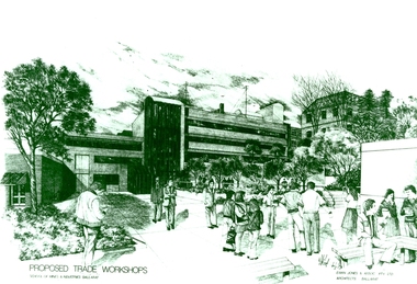
Photograph - Photograph - Black and White, Proposed Ballarat School of Mines Trade Workshops, c1984
A design for a Trade and Art Workshop at the Ballarat School of Mines was prepared by Ewan Jones and Associates on the Albert Street boundary around 1984. The M.B. John Building (Building K), a three storey, face red brick, restrained Late Twentieth Century International styled building with an elongated, cuboid form (defined by the parapeted facades) that is offset by projecting exposed concrete framed, round‐arched entrance and stair wells on the east (Albert Street) elevation (the centrally located entrance breaking the brick façade with glazing). The facades are also characterised by banks of aluminium framed, horizontal ribbon windows, which wrap around the building corners. Metal shades project beyond the windows, while post‐supported bullnosed verandahs and hoods and projecting concrete stairs are other features. On the west elevation, the cuboid façade is punctuated by projecting curved concrete and glazed, elongated bays at first floor level. (David Rowe/Wendy Jacobs) The M.B. John Trade–Art building of SMB was officially opened by the Hon. John Cain, Premier of Victoria, in the presence of Morgan B. John. Programs include 3 Dimensional Art, Painting & Decorating, and Engineering Trades. (SMB Institutional Plan 1989)Black and white photograph of a sketch for the proposed Trade Workshops at the Ballarat School of Mines, from the Albert Street vantage point. This building is known as the M.B. John Building on the SMB Campus.ballarat school of mines, trade workshops, flecknoe, m.b. john, ewan jones and associates pty ltd, albert street, morgan b. john, ewan jones and associates -
 Federation University Historical Collection
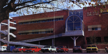
Image - Colour, Ballarat School of Mines M.B. John Building, Albert Street, Ballarat, 1987, 1987
The M.B. John Trade–Art building (Albert Street front) of SMB was officially opened by the Hon. John Cain, Premier of Victoria, in the presence of Morgan B. John. Programs include 3 Dimensional Art, Painting & Decorating, and Engineering Trades. (SMB Institutional Plan 1989) The M.B. John Building (Building K), a three storey, face red brick, restrained Late Twentieth Century International styled building with an elongated, cuboid form (defined by the parapeted facades) that is offset by projecting exposed concrete framed, round‐arched entrance and stair wells on the east (Albert Street) elevation (the centrally located entrance breaking the brick façade with glazing). The facades are also characterised by banks of aluminium framed, horizontal ribbon windows, which wrap around the building corners. Metal shades project beyond the windows, while post‐supported bullnosed verandahs and hoods and projecting concrete stairs are other features. On the west elevation, the cuboid façade is punctuated by projecting curved concrete and glazed, elongated bays at first floor level. (David Rowe/Wendy Jacobs)Image of a multi-storey brick building on the Ballarat School of Mines campus. The building is known as the M.B. John Building.ballarat school of mines, m.b. john building, morgan b. john, albert street, m.b. john -
Federation University Historical Collection
Poster - Signs, Window signs by Keith Rash
It is thought the signs were used for Ballarat's Gold Centenary in 1851.Seven window signs by Keith Rash painted onto wallpaper. The signs were designed to sit in shop windows to tell the history of the shop of company. .1) In 1862 Eurgene Bourdet conducted the "Imperial Dining Rooms" here. Board 20/- Board & Lodging 25/- week .2) On 16th Feb. 1853 at the Government Land Sale, Mr C.N. Thorne purchased this area. In 1893, R. Ludbrook used this property as Auction Rooms. .3) McArtney & aldred first occupied these premises in 1856. There were coachbuilders. .4) From the Single Storeyed wooden building once her J.P. Clarke operated as a carrier until 1865. Welsh & Surplice took over as Estate Agents until 1870. .5) Dr James Stewart built this property H.G. Harrison, 1957. J.C. Proctor 1862, John Stokes 1865, were chemists here. In 1856 The Savings Bank commenced here. W.H. Pooley, actuary .6) Wm Moss, tinsmith, occupied this site in 1865. Thos. Freeman,a uctioneer in 1882. .7) Doig & Cant. Gasfitters & Plumbers came here from Main Road in 1866. After 38 years A. Cant removed 2 doors further north .8) In 1871, This part was the shop of Wm Moss, tinsmith & plumberballarat, doig, cant, plumber, william moss, tinsmith, thomas freeman, james stewart, h.g. harrison, j.c. proctor, john stokes, savings bank, w.h. pooley, j.p. clarke, welsh, surplice, mcartney, aldred, coachbuilders, c.n. thorne, r. ludbrook, eugene bourdet -
 Federation University Historical Collection
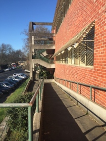
Photograph - black and white, Clare Gervasoni, Ballarat School of Mines M.B. John Buildings, 2016, 08/09/2016
The M.B. John Building (Building K), a three storey, face red brick, restrained Late Twentieth Century International styled building with an elongated, cuboid form (defined by the parapeted facades) that is offset by projecting exposed concrete framed, round‐arched entrance and stair wells on the east (Albert Street) elevation (the centrally located entrance breaking the brick façade with glazing). The facades are also characterised by banks of aluminium framed, horizontal ribbon windows, which wrap around the building corners. Metal shades project beyond the windows, while post‐supported bullnosed verandahs and hoods and projecting concrete stairs are other features. On the west elevation, the cuboid façade is punctuated by projecting curved concrete and glazed, elongated bays at first floor level. (David Rowe/Wendy Jacobs)Colour photograph of a red brick building on Albert Street. It was build to house trade workshops and Ceramics at the Ballarat School of Mines. m.b. john, m.b. john building, ballarat school of mines -
Federation University Historical Collection
Plan, Proposed New Buildings for the Ballarat School of Mines, 1966, 05/1966
The Diploma Subjects Building was designed to be erected on the M.B. John Factory site (Lydiard Street towards Armstrong St), to provide facilities for the tertiary sector of the Ballarat School of Mines. This proposal was aborted when the Mount Helen Campus site was acquired and a new campus started there in 1967. Many of the laboratories shown in these plans were incorporated, in modified form, in single-storey buildings on Mt Helen campus.Plans for proposed building for Diploma students at the Ballarat School of Mines. The building was not built.ballarat school of mines, proposed buildings, l.h. vernon and associates -
Federation University Historical Collection
Booklet, Report on the Viability of Establishing a Post Secondary Education Facility Located at the Aradale Traininf Centre, Ararat, Victoria, 1993, 12/1993
Aradale is located 3 km from the centre of Ararat and covers approximately 101 hectares. It consistes of an impresive group of mainly heritage buildings of national significance surrounded by open farmland. Aradale was designed in 1864 in the Victorian Italianate style by John James Clark of the Public Works Department, Victoria. A three storey nurses quarters was built in the 1930s and the Forensic Psychaitry Centre was established in the 1980s. The design of asylums as a specific building type orginated in England in the mddle of the 19th century when it was decided that 'pauper lunatics' would be better cared for in a separate institution rather than being house within the workhouses. Some of the early purpose built asylums were based on the radiating principle of prisons but the arrangement of separat wings at right angles used in hospitals and whorkhouse design soon came to be seen as the most appropriate. The largest 19th century asylum in England was built at Colney Hatch. Kew, Beechworth and Ararat Asylums closely followed the Colney Hatch model. In victoria the population rose due to the gold rushes resulting in severe housing shortages, and additional pressure on asylums. The first asylum in Melbourne was established at Y arra Bend. In 1862 a new asylum was established at Kew. Ararat Asylum and Beechworth Asylum were designed in 1864. Ararat was opened on 19 October 1867, with Beechworth Asylum opening five days later. Soft covered bookletararat regional development board inc., aradale training centre, aradale, grano street ararat, alfred st ararat, ivar nelson, john christie, jon duggan, wes matthews, peter helfer, michael burke, john grant, asylum, lunatic asylum, colney hatch asylum, ararat asylum, fever tents, sunbury asylum, kew asylum, beechworth asylum, wine industry training -
 Bendigo Historical Society Inc.
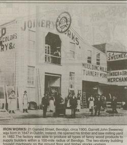
Newspaper - JENNY FOLEY COLLECTION: IRON WORKS
Bendigo Advertiser ''The way we were'' from 2000. Iron works: 21 Garsed Street, Bendigo, circa 1900. Garrett John Sweeney was born in 1847 in Dublin, Ireland. He opened his timber and saw milling yard in 1882. The factory was able to produce all types of fancy wood products to supply builders within a 100-mile radius of Bendigo. The two-storey building housed machinery on the ground floor and timber stocks upstairs. The clip is in a folder.newspaper, bendigo advertiser, the way we were -
 Bendigo Historical Society Inc.
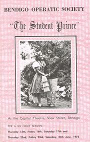
Document - THE STUDENT PRINCE, CAPITAL THEATRE, 15 June, 1972
The Student Prince, Capital Theatre, View Street, Bendigo. For a six night season: Thursday 15th, Friday 16th, Saturday 17th and Thursday 22nd, Friday 23, Saturday 24th June, 1972. Bendigo Operatic Society: Mr J McK. Cannon, Mr F Trewarne, Miss Ann Ball, Mr L Spencely, Mrs P Lyon. Committee: Mesdames J Cannon, M Reed, Misses P McCraken & M Welch, Messrs. J Beaumont, J Boquest, G Daws. Photos: Producer-Max Collis, Assistant Producer, Ballet & Wardrobe Mistress-Madge Welch, Assistant Pianist-Edith John, Musical Director-Gwen Grose, Society Pianist- Ruth Gorman. Photos of cast: Margaret McQueenie, John Boquest, John McCormack, Graham Bumford, Graeme Daws, Annette Beckwith, Jill James, Ferd Lorenz, Shane Brennan, Patricia Lyon, Max Rule, Ian Beckwith, John Tonkin, Michael Filippini, Valerie Griffiths, Jim Feteris. Synopsis if Story. Synopsis of Scenes. Bendigo Operatic Society Presents by arrangement with Allan's Music (Australia) Pty. Ltd. ''The Student Prince'' A Max Collis Production. Music by Sigmond Romburg. Book & Lyrics by Dorothy Donnelly. Stage Manager Malcolm Cannon. Musical Director Gwen Grose. Choreography Madge Welch. Wardrobe Miss M Welch, Mrs A Ball. Cast: Kerry Hogan Brian Fitzpatrick, Garry Burns, Alan Petrie, Graham Bumford, John McCormick, John Boquest, Graeme Daws, Annette Beckwith Margaret McQueenie, Michael Filippini, Nicholas Kasterovic, Max Rule, Graham Bumford, Ian Beckwith, Ferd Lorenz, Shane Brennan, Jill James, Patricia Lyon, Valerie Griffiths, Jim Feteris, John Tonkin. Time _ Spring 1860. Female Chorus: Marion Alcock, Ann Ball, Wilma Baldwin, Dorothy Field, Ann Garrat, Dawn Moncrieff, Coral Rivett, Lois Semmens, Marilyn Storey, Marion Wright. Male Chorus: Garry Burns, Edmund, Burke, Peter Edgley, Brian Fitzpatrick, Jim Feteris, Kerry Hogan, Ross Jones, Nicholas Kasterovic, Bernie Keogh, John Keogh, Alan Petrie, Fred Trewarne, Philip Wilkin. Ballet: Dianne Austin, Annette Basset, Wendy Kent, Jocelyn Lyon, Lyn Rowe, Ann Rendell, Helen Southby, Pauline Waugh. Publicity Officer: Mrs J Cannon. Scenery & Properties: M & J Cannon, J Moncrieff, R Spicer. Art Work: M Cannon, S James, B Agnew, Tony Lorenz, J Hall, Karl Steinberg. Prompt: Mrs J Cannon. Lighting: L Reed, H Bridges & T Vincent. Make-up: Mrs H Cannon & Mrs D Coia. Hairdressing: Ross Coiffure. House Manager: Garry McDonald. Bendigo Concert Orchestra Violins: Mrs R Weldon, Mrs A Boulton, Mrs M Robbins, Mrs C Messer, Mr C Gill, Mr J Jordan, Mr P Phillips, Mr T French. Violas: Mr E Jarrett, Mr H Werry. Cellos: Mrs C Bubb. Bass: Mr S Anderson. Flute: Mr C Bubb. Clarinets: Mr R Holyoake. Trombones: Mr W Neuman. Trumpets: Mr D Gray, Mr David Gray, Mr Ian De Araugc. Percussion: Mr Brian Beale. Pianoforte: Mrs P Gorman. Songs From ''The Student Prince'' (wording). Acknowledgement; Bendigo Advertiser, BCV8, 3BO, 3CV, St Mary's. Advertisements through last half of program: Don Semmens Photographic Studio, The Copper Pot Licensed Restaurant, Ross Coiffure Beatty Salon. A and b are both the same copy a in the better of the copies as b is lightly faded. Otherwise excellent condition.program, music, bedigo operatic society, the student prince, capital theatre, view street, bendigo. 15th, 16th, 17th 22nd, 23, 24th june, 1972. bendigo operatic society: mr j mck. cannon, mr f trewarne, miss ann ball, mr l spencely, mrs p lyon. committee: mesdames j cannon, m reed, misses p mccraken & m welch, messrs. j beaumont, j boquest, g daws. photos: producer-max collis, assistant producer, ballet & wardrobe mistress-madge welch, assistant pianist-edith john, musical director-gwen grose, society pianist- ruth gorman. photos of cast: margaret mcqueenie, john boquest, john mccormack, graham bumford, graeme daws, annette beckwith, jill james, ferd lorenz, shane brennan, patricia lyon, max rule, ian beckwith, john tonkin, michael filippini, valerie griffiths, jim feteris. synopsis if story. synopsis of scenes. bendigo operatic society presents by arrangement with allan's music (australia) pty. ltd. ''the student prince'' a max collis production. music by sigmond romburg. book & lyrics by dorothy donnelly. stage manager malcolm cannon. musical director gwen grose. choreography madge welch. wardrobe miss m welch, mrs a ball. cast: kerry hogan brian fitzpatrick, garry burns, alan petrie, graham bumford, john mccormick, john boquest, graeme daws, annette beckwith margaret mcqueenie, michael filippini, nicholas kasterovic, max rule, graham bumford, ian beckwith, ferd lorenz, shane brennan, jill james, patricia lyon, valerie griffiths, jim feteris, john tonkin. time _ spring 1860. female chorus: marion alcock, ann ball, wilma baldwin, dorothy field, ann garrat, dawn moncrieff, coral rivett, lois semmens, marilyn storey, marion wright. male chorus: garry burns, edmund, burke, peter edgley, brian fitzpatrick, jim feteris, kerry hogan, ross jones, nicholas kasterovic, bernie keogh, john keogh, alan petrie, fred trewarne, philip wilkin. ballet: dianne austin, annette basset, wendy kent, jocelyn lyon, lyn rowe, ann rendell, helen southby, pauline waugh. publicity officer: mrs j cannon. scenery & properties: m & j cannon, j moncrieff, r spicer. art work: m cannon, s james, b agnew, tony lorenz, j hall, karl steinberg. prompt: mrs j cannon. lighting: l reed, h bridges & t vincent. make-up: mrs h cannon & mrs d coia. hairdressing: ross coiffure. house manager: garry mcdonald. bendigo concert orchestra violins: mrs r weldon, mrs a boulton, mrs m robbins, mrs c messer, mr c gill, mr j jordan, mr p phillips, mr t french. violas: mr e jarrett, mr h werry. cellos: mrs c bubb. bass: mr s anderson. flute: mr c bubb. clarinets: mr r holyoake. trombones: mr w neuman. trumpets: mr d gray, mr david gray, mr ian de araugc. percussion: mr brian beale. pianoforte: mrs p gorman. songs from ''the student prince'' (wording). acknowledgement; bendigo advertiser, bcv8, 3bo, 3cv, st mary's. advertisements: don semmens photographic studio, the copper pot licensed restaurant, ross coiffure beatty salon. -
 Bendigo Historical Society Inc.
Photograph - UNKNOWN FAMILY COLLECTION: PHOTOGRAPH
Photograph - postcard - sepia. A photo of a 2 storey house. Written on back 'Caradon' Borough of Eaglehawk's Municipal Offices. Built for a Doctor in the late 1890's. Later purchased by Mining Magnate John Hooper and still occupied by his descendents when bought by the Council in 1981. From Barry.buildings, government, eaglehawk municipal offices., 'caradon' borough of eaglehawk's municipal offices. -
 Bendigo Historical Society Inc.
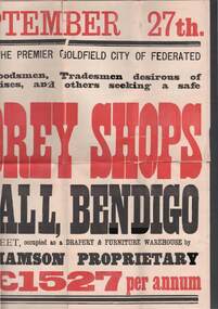
Document - BUILDINGS FOR SALE BENDIGO, Fri.27 Sep 1861-1878
Document, Buildings For Sale in Bendigo C.B.D. Could be in these years 1861-1878, Friday 27th September. 4 two storey shops in the very heart of Pall Mall Bendigo also extensive premises in William St occupied as a Drapery & furniture Warehouse by Messrs Craig , Williamson Proprietary producing total rental of 1527 pounds per annum . .Maurice Moran co …to sell by public auction ..the whole of the property in the estate of the late Gavin Gibson …lot 1 Pall Mall -two brick shops occupied by Mr C.W. Hyett , Bookseller and 2 Mr John Lay Chemist (3) suite of offices let to Mr John Lay Dentist … Solicitors -Messrs Snowden , Neave and Demaine , chancery and Melbourne …Maurice Moran & co Williamson St Bendigo … J.B. Young Printer . Lithographer Bendigo……. The document appears to be circa 1888 ---(27.9.1888 ?) after Gibson's death in 1888J.B.Young, Printer, Lithographer, &c, Bendigo.document, newspaper, bendigo theme -
 Bendigo Historical Society Inc.
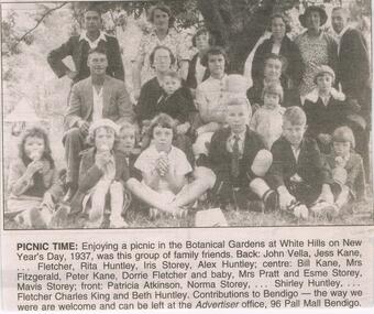
Newspaper - JENNY FOLEY COLLECTION: PICNIC TIME
Bendigo Advertiser "The way we were" from Tuesday, November 2, 2004. Picnic time: Enjoying a picnic in the botanical gardens at White Hills on New Year's Day, 1937, was this group of friends. Back John Vella, Jess Kane, ? Fletcher, Rita Huntley, Iris Storey, Alex Huntley. Centre: Bill Kane, Mrs Fitzgerald, Peter Kane, Dorrie Fletcher and baby, Mrs Pratt and Esme Storey, Mavis Storey. Front: Patricia Atkinson, Norma Storey, ?, Shirley Huntley, ? Fletcher, Charles King and Beth Huntley.newspaper, bendigo advertiser, the way we were -
 Robin Boyd Foundation
Document - Manuscript, Robin Boyd, Living and Partly Living. The Neighbourhood, 1971
A discussion of Australia's bland suburbs, and the rise in brick home-building, and the alternative of urban high-rise living. Alternative leisure lifestyles associated with each are outlined. Multi-storey flats, European migration, the unplanned ghettoisation of different groups are discussed. What are the needs for a new era of Australian housing? New initiatives are outlined.Original manuscript of the chapter titled 'The Neighbourhood' (pp32-43) by Robin Boyd in the book "Living and Partly Living", by Ian McKay, Robin Boyd, Hugh Stretton and John Mant, published by Nelson, Sydney 1971.Typewritten (c copy), pencil, quarto, 29 pagesChapter in a book.neighbourhood, neighborhood, suburbia, planning, conformity, brick home, timber home, flathouses, housing commission, european immigration, swinger hill, ian mackay, merchant builders, landscaping, robin boyd, manuscript -
 Robin Boyd Foundation
Document - Manuscript, Robin Boyd, Announcing the end of the glass box and the birth of a new 3D city architecture, 1965
Discussion of the history of the 'glass box', i.e. the glazed curtain wall skyscraper and its appearance and demise in Australia. Also discusses the phenomenon of multi-storey car parks, and RMIT student designs for Victoria Market.Published as "Death notice: The End of the Glass Box/Birth Notice: A New 3-D Style for a City" in 'The Australian' on 13/11/1965.Typewritten (c copy), quarto, 8 pagesaustralia square, bates, smart & mccutcheon, john a la gerche, walter gropius, ici house, mcconnel, smith and johnson, harry seidler, sydney opera house, un secretariat, bogle and banfield, peter mcintyre, robin boyd, manuscript -
 Hume City Civic Collection
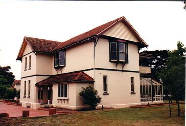
Photograph, 1990s
The double storey Federation style house was built in 1911 for Dr. William Cooke Faulkner who was the local doctor until his death in 1922. It was then bought by the local state school headmaster, John James Rogers, for over 6,500 pounds. In the early 1940s a grazier, Eric George Whiteside, bought the property. Bill Landeryou, MLC lived in the house until the late 1980s. He had purchased it from the Campbell family.A coloured photograph of 'Arcloney' a Federation style house with a red terracotta gable roof and cream rendered walls. The wooden frames around the windows have been painted dark green and cream. There is a glassed conservatory to the rear of the building.arcloney, faulkner, william cooke, dr., rogers, john james, whiteside, eric george, landeryou, bill mlc, george evans collection -
Whitehorse Historical Society Inc.
Document, Colombo Street Buildings, 1/06/2004 12:00:00 AM
Detailed plans and drawings of proposed multi-storey buildings for Colombo Street, Mitcham.Detailed plans and drawings of proposed multi-storey buildings for Colombo Street, Mitcham. Also includes photos of Mitcham area around the buildings.Detailed plans and drawings of proposed multi-storey buildings for Colombo Street, Mitcham.colombo street, mitcham, mitcham, whitehorse road, mitcham, mitcham railway station, st johns catholic church, mitcham, station street, mitcham, high rise buildings -
Whitehorse Historical Society Inc.
Article, School To Close Its Doors, 16/12/1987 12:00:00 AM
Forest Hill Primary School closes in its 60th year.Forest Hill Primary School closes in its 60th year. President of the School Council, John Burrill, said Forest Hill P.S. Trusts would be introduced at Nunawading South, Blackburn Lake and Parkmore Primary Schools as a permanent Memorial to the School. The money earned as interest will be used to enable needy students to participate in educational excursions.Forest Hill Primary School closes in its 60th year. primary schools, forest hill primary school, burrill, john, tonkin, florence, sedgman, ruth, storey, gareth, davis, scott, coropel, peter