Showing 164 items
matching local tourism
-
 Warrnambool and District Historical Society Inc.
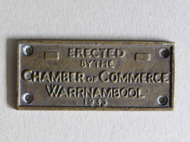
Brass Plate, Chamber of Commerce 1933, 1933
... the development of local industry and the tourism trade. ... and the tourism trade. This plaque is of great local interest ...This plaque has been attached to a Warrnambool installation in 1933. It is not known to which site this refers but it may have been the Warrnambool Information Pavilion which was erected outside the old Warrnambool City Council Chambers. There have been many Warrnambool Chambers of Commerce over the years. These were established by Warrnambool businessmen and women to promote the interests of the town/city and to encourage the development of local industry and the tourism trade. This plaque is of great local interest but unfortunately does not have a clear provenance.This is a small brass plaque. The plaque has four holes at each corner for attachment to a building or other object. ‘Erected by the Chamber of Commerce, Warrnambool, 1933’warrnambool chamber of commerce, warrnambool city council chambers, plaque -
 Glenelg Shire Council Cultural Collection
Booklet - Program, Portland Upwelling Festival 2010, 2010
... and is the cornerstone of the lucrative local fishing and tourism industry... of the lucrative local fishing and tourism industry. The Festival ...Program for the 2010 Upwelling Festival. The Upwelling Festival Portland is a community celebration of the Bonney Upwelling, presented by the Upwelling Festival Incorporated and including a partnership with other community groups. The Upwelling Festival celebrates what is unique about Portland and the community and show cases an important environmental phenomenon – the Bonney Upwelling. The Bonney Upwelling is a unique and epic natural ocean phenomena where the spring winds shift to the south-east driving a change in ocean currents that powers a seven month feeding frenzy of tuna, crayfish, giant crabs, squid, fish, seabirds, seals, krill and blue whales. An incredibly rich ecological food web, the Upwelling is at its greatest off the coast of Portland and is the cornerstone of the lucrative local fishing and tourism industry. The Festival is a free event maintaining the key elements of the Blessing of the Fleet, Street Parade, Festival markets, local entertainment, Marine Environment Talks and community art projects on the site.Upwelling FestivalA4 sheet folded in 4, to make program advertising Upwelling Festival 2010. Glossy white paper, illustrations on front cover in blues, greens. Back cover sponsors logos. Inside pages, Festival explanation and list of events. Two copies.upwelling festival, events, tourism, whales, portland -
 The Beechworth Burke Museum
Photograph, 1999
This photograph depicts members of the Beechworth Band at a 'Liedertafel' concert in the main hall at the Burke Museum in 1999. The concert was associated with an exhibition titled, 'From the Liedertafel to the Skating Rink: Entertainment in Beechworth 1852 - early 1900s', which celebrated the rich and diverse entertainments that were a part of Beechworth life in the nineteenth and early twentieth centuries. Marching bands, choirs, circus acts, theatrical performances, races, and seasonal activities, such as Mr. Spiller's roller skating rink, founded in the late 1860s, were among the attractions on offer. 'Liedertafel' is a tradition that accompanied German settlers to Australia. It refers to a friendly society of men united by an enthusiasm for singing. The Beechworth Brass Band was formed by Mr. H. Vandenberg in 1887. The Beechworth Liedertafel was established 14 March 1894 at the London Tavern, Camp Street, Beechworth, by Mr. A.A. Billson, and a visiting conductor, Mr. H. Fielder. German clubs, complete with marching bands, athletics associations and Liedertafel choirs, were centres of social activity attracting wide audiences not limited to members of their own ethnicity. Alfred Arthur Billson was the youngest son of Mr. George Billson, who served as Beechworth’s mayor between 1869-1871. In 1872, George purchased the Oven’s Brewery in Last Street, which became Billson’s Brewery, one of the oldest continuing beverage manufacturers in Australia. An active member of Beechworth’s cultural, business and political life around the turn of the century, A.A. Billson served on Beechworth Shire Council from 1884 to 1893, and from 1895 to 1910, with three terms as president (1888–89, 1899–1901, 1908–09). He founded the Beechworth Progress Association in 1891 and produced an ‘Illustrated Guide to Beechworth and Vicinity’ to develop tourism potential. This photograph of the Beechworth Band playing at the Burke Museum is historically significant for the information it conveys about an exhibition at the Burke Museum between September and November 1999. The use of the contemporary Beechworth Band in a 'Liedertafel' performance provides insight into curatorial approaches at the turn of the twenty-first century and improves our understanding of how exhibitions use objects in the Burke Museum's Collection to tell stories about the past in the present. The image is historically and socially significant for attesting to the enduring appeal of local musical associations, which were a popular means of entertainment that fostered social connections among settlers from diverse ethnic backgrounds. Rectangular colour photograph printed on matte photographic paper. Reverse: 7029 / Label: 7029 / Source / Burke Museum / Beechworth / Band / 1999/2000 /liedertafel, beechworth band, burke museum, from the liedertafel to the skating rink, entertainment in beechworth 1852 - early 1900s, gold rush, immigration, beechworth's german heritage, london tavern beechworth, beechworth's first brick tavern, spiller's skating rink, vandenberg's beechworth brass band, protestantism, teetotallism, skating carnivals, beechworth german association, yma's, beechworth skating rink, progress societies, billson's brewery, german-australians, beechworth progess association, lodges, freemasonry, colonial australia -
 The Beechworth Burke Museum
Photograph, c1999-2000
This photograph taken c1999/2000, depicts the Burke Museum’s granite façade and vestibule entrance. The museum's large red door is closed and there is a white sign is attached to the door. The museum site dates to the 1857 founding of the Beechworth Public Library and Athenaeum by a newly formed Young Men's Association (YMA). In 1863 the museum was dedicated as a memorial to former Beechworth police superintendent (1854-1858) and explorer Robert O’Hara Burke, following Burke’s death from malnutrition on the Burke and Wills expedition in 1861. Funded by the Victorian Government and the Royal Society of Victoria, the officially titled 'Victorian Exploring Expedition' was tasked with being the first European party to traverse Australia from south to north. The Burke Museum holds objects from the famous expedition and explores the multi-layered history of Beechworth and surrounds from the gold rush era to the present.This photograph is historically significant for its depiction of the Burke Museum c1999/2000. The Burke Museum is Australia’s oldest regional museum and part of Beechworth's Historic and Cultural Precinct, one of Australia’s best preserved historic-town sites and a popular tourist destination. Once the government centre for a vast gold fields region, this collection of nationally significant buildings tells the story of how Australia grew and prospered. The frequent use of honey-coloured local granite as a building material, which can be seen in the museum's fabric, gives Beechworth’s historic buildings a distinct and cohesive local character. This photograph captures this distinctive character and may be compared and studied alongside other images of historic buildings in the Burke Museum Photographic Collection.Rectangular colour photograph printed on photographic paper.Reverse: 7031 / Label: Burke Museum / 1999/2000 /burke museum, indigo shire, beechworth athanaeum, beechworth library, beechworth historic building, historic precinct, burke museum exhibition, from the liedertafel to the skating rink, honey-coloured local granite, robert o'hara burke, victorian gold fields, historic towns in victoria, colonial australia, liedertafel, colonial entertainments, beechworth brass band, historic victorian architecture, australia's oldest regional museum, burke and wills expedition, first europeans to cross australia, yound mens associations, beechworth tourism, things to see in beechworth, beechworth historic trail, young men's associations -
 The Beechworth Burke Museum
Photograph, Unknown
This undated photograph depicts two people standing in the vestibule entrance at the Burke Museum, Beechworth. The museum site dates to the 1857 founding of the Beechworth Public Library and Athenaeum by a newly formed Young Men's Association (YMA). In 1863 the museum was dedicated as a memorial to former Beechworth police superintendent (1854-1858) and explorer Robert O’Hara Burke, following Burke’s death from malnutrition on the Burke and Wills expedition in 1861. Funded by the Victorian Government and the Royal Society of Victoria, the officially titled 'Victorian Exploring Expedition' was tasked with being the first European party to traverse Australia from south to north. The Burke Museum holds objects from the famous expedition and explores the multi-layered history of Beechworth and surrounds from the gold rush era to the present.This photograph is historically significant for its depiction of the Burke Museum and Loch Street streetscape. The Burke Museum is Australia’s oldest regional museum and part of Beechworth's Historic and Cultural Precinct, one of Australia’s best preserved historic-town sites and a popular tourist destination. Once the government centre for a vast gold fields region, this collection of nationally significant buildings tells the story of how Australia grew and prospered. The frequent use of honey-coloured local granite as a building material, which can be seen in the museum's fabric, gives Beechworth’s historic buildings a distinct and cohesive local character. This photograph may be compared and studied alongside other images of historic buildings in the Burke Museum Photographic Collection.Rectangular colour photograph printed on photographic paper.Reverse: 3440burke museum, beechworth athenaeum, beechworth library, beechworth historic precinct, robert o'hara burke, australia's oldest regional museum, indigo shire, beechworth athanaeum, beechworth historic building, historic precinct, honey-coloured local granite, victorian gold fields, historic towns in victoria, victoria's high country, colonial australia, beechworth tourism, things to see in beechworth, beechworth historic trail, historic victorian architecture, burke and wills expedition, first europeans to cross australia, young men's associations -
The Beechworth Burke Museum
Audio - Oral History, Jennifer Williams, Robert Mason, 3 August 2000
Mason Robert was born in (unintelligible) in 19(unintelligible). Mason's grandparents were from Stanley, where Mason completed his schooling. Mason started working for the Forestry Commission in 1939 looking after Crown land but eventually went into the army in 1942. At the Forestry Commission, he was responsible for maintaining and looking after the land. Mason later went to work for the Lands Department after working at the Commission for seven years. This oral history recording was part of a project conducted by Jennifer Williams in the year 2000 to capture the everyday life and struggles in Beechworth during the twentieth century. This project involved recording seventy oral histories on cassette tapes of local Beechworth residents which were then published in a book titled: Listen to what they say: voices of twentieth century Beechworth. These cassette tapes were digitised in July 2021 with funds made available by the Friends of the Burke.Mason Robert's account of his life in Beechworth and the local area during the 20th century is historically and socially significant to the cultural heritage of the region. He recalls some of the changes that Beechworth underwent such as the introduction of electricity in the 1950s and an increase in tourism. His account is important to the region's history in terms of important historical events such as WWII and other events impacting the region. This oral history account is socially and historically significant as it is a part of a broader collection of interviews conducted by Jennifer Williams which were published in the book 'Listen to what they say: voices of twentieth-century Beechworth.' While the township of Beechworth is known for its history as a gold rush town, these accounts provide a unique insight into the day-to-day life of the town's residents during the 20th century, many of which will have now been lost if they had not been preserved.This is a digital copy of a recording that was originally captured on a cassette tape. The cassette tape is black with a horizontal white strip and is currently stored in a clear flat plastic rectangular container. It holds up 40 minutes of recordings on each side.Mr. Robert Mason/beechworth, mason robert, forestry commission, lands department, crown land, wwii, listen to what they say, burke museum, jennifer williams, oral history -
 The Beechworth Burke Museum
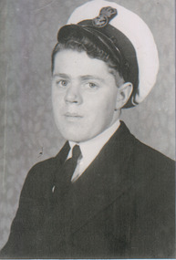
Audio - Oral History, Jennifer Williams, Mr Ray Stone, 8th June 2000
Ray Stone was born in 1927, growing up in Beechworth as the oldest of eight children, but spent much of his life travelling, which he recalls in this oral history. Although he started working at the Beechworth Tannery with his father, he joined the Navy before he was of age in 1944 to support the war effort, and upon returning to Beechworth gave up on the Tannery after half a day to continue working jobs across Victoria instead. He talks extensively about watching Beechworth's famous Wheelbarrow race, where Tony Evans bet Tom Parkinson that the latter would not be able to push the former in a wheelbarrow from the Beechworth Post Office to Mt Buffalo in eight days. Calling himself a "helper all [his] life", he discusses the way many towns he worked in would come together to support struggling families, especially widows. In comparison, he suggests that the Beechworth of 2000 is much less community-orientated. He also discusses the economic changes he's witnessed around Beechworth, from the difficulties during the Depression while he was a child, to business improvements at the Tannery and Brewery, to the tourism boom. This oral history recording was part of a project conducted by Jennifer Williams in the year 2000 to capture the everyday life and struggles in Beechworth during the twentieth century. This project involved recording seventy oral histories on cassette tapes of local Beechworth residents which were then published in a book titled: Listen to what they say: voices of twentieth century Beechworth. These cassette tapes were digitised in July 2021 with funds made available by the Friends of the Burke.Ray Stone's account of his life is historically and socially significant to the region of Beechworth for the way it describes changes in the town over the twentieth century. It covers themes including community relationships, business development, and cultural life. It makes this commentary in comparison to nearby regions such as the Snowy Mountains. This oral history account is socially and historically significant as it is a part of a broader collection of interviews conducted by Jennifer Williams which were published in the book 'Listen to what they say: voices of twentieth-century Beechworth.' While the township of Beechworth is known for its history as a gold rush town, these accounts provide a unique insight into the day-to-day life of the town's residents during the 20th century, many of which will have now been lost if they had not been preserved.This is a digital copy of a recording that was originally captured on a cassette tape. The cassette tape is black with a horizontal white strip and is currently stored in a clear flat plastic rectangular container. It holds up 40 minutes of recordings on each side.Mr Ray Stone /listen to what they say, beechworth, oral history, burke museum, stone, ray stone, tannery, tanneries, finch street, navy, the great depression, poverty, wheelbarrow race, cars, gift footrace, marriage, travel -
 The Beechworth Burke Museum
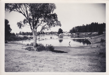
Photograph, 1960s
This photograph was taken in the 1960s of the Lake Sambell Swimming Pool with the lake itself in the background. The swimming pool area has multiple features including park benches, a water slide, and a fenced area with a diving pontoon for lap swimming and racing. Lake Sambell Swimming Pool was completed in 1961, driven largely by R.E. Carter, Beechworth shire engineer from 1954-63. Carter advocated for improvements to the lake and surrounding area in order to encourage tourism in Beechworth. The opening of the swimming pool was part of many improvements to Lake Sambell made during this period by Carter including establishing the caravan park in 1959, water skiing and boating facilities, and increasing the lake surface in 1964. These improvements were financed mainly by grants from the Tourist Development Authority. For many decades, members of the local Beechworth community had advocated for the development of swimming pool at the lake that would include a safe wadding area and Olympic standard lanes for laps and races. Throughout the 1940s the Beechworth Swimming Club tried to raise awareness and funds to address the structural engineering issues, raise the water levels, and improve swimming facilities at the lake. Beechworth Swimming Club hosted a swimming carnival at the lake in 1948, but it was decided due to several issues at the event, that no further carnivals would be hosted until necessary improvements were made to the area. Swimming pools, both artificial and built into natural environments, were an extremely popular public space throughout the 20th century in Australia. Increasing in accessibility and popularity through such developments as less restrictive swimming outfits during 1920s, public building works during the 1920s and 30s, and an increase in leisure time during a period of post-war prosperity. This photograph is of historical significance as it documents the newly established Lake Sambell Swimming Pool in the 1960s after many decades of discussion and proposals around creating a safe swimming area at the lake. Further, this photograph provides important social insights into the facilities and uses of this pool in the 1960s, and underlines the significant role public swimming pools have played in Australian social and recreational experiences. Black and white rectangle photograph printed on photographic paper and unmounted.Reverse: 3537 / C798lake sambell swimming pool, lake sambell water slide, water slide 1960s, lake sambell pontoon, lake sambell 1960s, lake swimming pool, lake swimming, beechworth swimming club, swimming pools in the 20th century, r.e. carter, tourist development authority, beechworth 1960s, lake water slide, lake sambell, wadding pool, swimming, swimming pool 1960s, leisure, recreation 1960s -
 The Beechworth Burke Museum
Photograph
The photograph depicts two young men standing atop a prominent outcrop at Lake Sambell, with buildings visible on the further shore. The present day park and reserve occupies the site of the former Rocky Mountain Mining Company, an open-cut sluice mine that began operations in the mid-Nineteenth Century and operated until the early 1900s, through the peak of Victoria’s Gold Rush. It was converted into a park and leisure area in the 1920s. Lake Sambell was formally opened to the public on Friday 5th October 1928 and was opened by the Victorian Government’s Minister of Lands, Mr Bailey, as part of initiatives to boost the economies and development of country towns. The lake was named after Mr L.H. Sambell, a shire engineer and secretary of the Forward Beechworth Committee who was involved in promoting the transformation of the mining site and promoting plantation forestry and tourism as alternative industries. £300 to begin the process was provided by Mr J. McConvill, a former resident of Beechworth, who is remembered in a street name adjacent to the lake. An article in the Ovens and Murray Advertiser on Saturday, 5th May, 1917, gives some insight into issues in the Rocky Mountain Mining Company’s final years. The writer details the 1917 annual meeting of the Rocky Mountain Mining Company, stating that locals present appeared ‘well pleased this important local industry is in such a prosperous condition and that future prospects are so encouraging’. The author describes plans to give workers a bonus as evidence of profit-sharing that would ‘bridge the gulf between capital and labour’. The article concludes, however, with the statement that ‘there is a little arithmetical puzzle in the report in connection with the dredging operations I have been unable to solve.' The photograph is significant as it contributes to knowledge about how Beechworth reinvented itself after the Gold rush period, and more broadly how country towns repurpose and redevelop infrastructure and facilities to meet the present needs of their population. Sepia rectangular photograph printed on matte photographic paper. Obverse: nil. Reverse: 3471 / Velox (paper mark)beechworth, beechworth lake, lake sambell, l.h. sambell, mcconvill, rocky mountain mining company, rocky mountain mining co, minister of lands, forward beechworth committee, wallace park-lake sambell development scheme, wallace park lake sambell development scheme, lake, sambell, j. mcconvill, recreation, reserve, park, transformation, repurposed, redeveloped -
 Orbost & District Historical Society
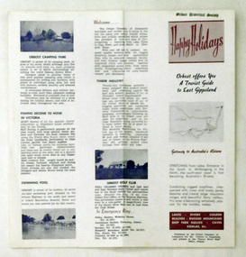
pamphlet, Snowy River Mail, Happy Holidays
... of the local area. tourism-orbost Two single page tourist brochures ...This pamphlet was probably produced for use in the Slab Hut (Orbost Visitor Information Centre)These pamphlets are useful reference tools and reflect the tourism history of the local area.Two single page tourist brochures, printed on both sides and folded in the middle. They are white with pink and blue print. and have a map of East Gippsland and descriptions of places to visit.tourism-orbost -
 Phillip Island and District Historical Society Inc.
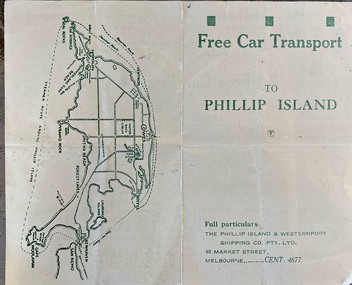
Booklet (item) - Brochure, Free Car Transport to Phillip Island
The Phillip Island & District Shipping Company was previously owned by Mr Arthur Keaston Sambell who had offerred concessions for travel to locals.HistoricalFree transport for Sunday returns between Stony Point & Cowes, for winter months of June, July and August. Phillip Island has miles of woodland roads where the friendly Koalas may be seen from the car with the glorious colour effects on a typical winter day with a mild atmosphere and brilliant sunshine. ferries, sea transport, tourism -
 Phillip Island and District Historical Society Inc.
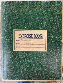
Book, Articles on severance poll concerning split from Shire of Phillip Island and Woolamai 1925-1929, 1925-1929
... . Historical D.H.Robb Severance of Phillip Island Local government ...Issue of severance of Phillip Island from the Shire of Phillip Island and Woolamai to become Shire of Phillip Island 1925-1929. This issue had strong opinions on both sides amongst Island residents and shows the political landscape of the times. This is a snapshot of life on Phillip Island in the 1920s. Book also contains notes, poem by D.H. Robb in his handwriting.HistoricalGreen exercise book with handwritten notes, articles from newspapers, pamphlets.Cover states D.H.Robb, Cowes. Lists of absentee ratepayers and householders, objectors,d.h.robb, severance of phillip island, local government, w.d.davie, akt sambell, women's progress association, phillip island early roads, phillip island valuations, local identities, reverend rath, tourism, phillip island 1920s, farming -
 Phillip Island and District Historical Society Inc.
Letter, Letter to Minister for Water Supply 1936, 27 May 1936
... . It includes figures on tourism, valuations of local properties, local... connected to Cowes. It includes figures on tourism, valuations ...Early attempts to have a water supply connected to Cowes. It includes figures on tourism, valuations of local properties, local primary produce and what water they require.HistoricalFoolscap size carbon copy of typed letter. 7pagesThe Honourable The Minister for Water Supply. Suggested motions to be put to the meeting of ratepayers, 13 May 1936water supply, shire of phillip island, agriculture, isle of wight, anderson property, valuations, charmadene, bonnie doon guest house, population, tourism, primary produce, d h robb, r a grayden, h v johnston, j thornborrow, e r scott -
 Phillip Island and District Historical Society Inc.
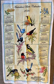
Souvenir, Australian tea towel, About 2005
... bought by tourists from local shops. Historical Tourism souvenir ...One of the most popular souvenirs bought by tourists from local shops.HistoricalColoured linen tea towel with yearly calendar, drawings of Australian birds and native plants.Australian Birds Calendar 2006. With compliments Jim & Margaret Ellis Cowes Newsagency 5952-2046tourism, souvenir, jim & margaret ellis -
 Warrnambool and District Historical Society Inc.
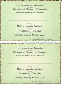
Document, Made in Australia Exhibition, 1950s
No information has been found regarding this exhibition in Warrnambool. The card design indicates that the exhibition may have been in the 1950s. The Warrnambool Chamber of Commerce has been operating at various times in the 20th century and was formed by the local businesses to promote Warrnambool as a city for business initiatives, tourism and economic development. These tickets are of some interest as an example of the activities of the Warrnambool Chamber of Commerce in the mid 20th century. These are two identical tickets, with black printing on a green background on one side and blank on the other side. The edges of the cards are gold- tipped in a serrated pattern.‘The President and Committee of the Warrnambool Chamber of Commerce requests the pleasure of the company of ….. at the Made in Australia Exhibition at the Warrnambool Town Hall on Thursday Evening, October 22nd, E. M. Dempster, Organizer’. made in australia exhibition, warrnambool, warrnambool, warrnambool chamber of commerce, e dempster -
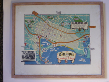 Warrnambool and District Historical Society Inc.
Advertising, Tourist Map of Warrnambool (framed x 2), 1950s
These framed tourist maps came from the Lane Foundation so it is presumed that they were from the office of Lane’s Travel Service which operated from 205 Raglan Parade Warrnambool with the known dates, the 1950s and 1960s. The proprietor, Alan Lane, was a successful Warrnambool businessman who operated a Warrnambool and district bus service as well as his travel business. He was heavily involved in local community affairs being a Warrnambool Councillor for 18 years from 1952 to 1970 and President of the Warrnambool Chamber of Commerce for six years. He was a major donor to the Warrnambool Performing Arts Centre, the Warrnambool Art Gallery and the St. John of God Hospital and left the bulk of his estate to the Alan Lane Foundation which has contributed millions of dollars to local organizations and programs. Alan Lane died in 1995. These framed maps are of some interest as examples of the tourism maps used to promote the city and district in the 1950s and 60s. This is a tourist map of the Warrnambool C.B.D. and adjoining streets produced as an advertisement for Olympic Tyres. It is multi-coloured and has cartoon sketches of the main tourist attractions and pointers to attractions outside of the main city area. It includes an inset black and white photograph of the Warrnambool Botanic Gardens and an advertisement for Olympic Tyres. It is printed on a white background and is enclosed behind glass in a wooden frame of a light brown colour. It has a wire at the back for attachment to a wall. ‘Warrnambool – 163 miles from Melbourne – a popular tourist resort offering many holiday attractions – an ideal surfing beach with all modern facilities is avalable’ ‘Fit Olympic Tyres, Champions of the Road’ alan lane foundation, warrnambool tourism -
 Warrnambool and District Historical Society Inc.
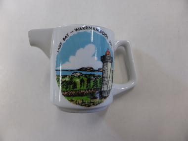
Jug, 'Lady Bay' transfer, 1960s
This is a souvenir jug made for the local tourist trade in the 1960s. The jug has an image of Lady Bay, Warrnambool. The official name of Lady Bay is Warrnambool Bay. The jug was made by Westminster Fine China Australia, a firm established in 1954 by the cutlery and silverware firm of Stanley Rogers and Sons of Melbourne. Westminster China was fist established in Cheltenham in Melbourne and after 1977 it was operating in Sandringham, Victoria. It was still operating in the 1990s and produced mainly souvenir and giftware. This jug is retained because it is a good example of the souvenir items offered to local tourists in the 1960s. This is a small white china jug with a gold strip down the handle and a gold rim around the opening and the lip. On the side of the jug is a multi-coloured image of the lower lighthouse and Lady Bay, Warrnambool. The maker’s name is on the base of the jug. ‘Lady Bay Warrnambool Vic.’ ‘Fine China Westminster Australia’ warrnambool bay, westminster china, australia, tourism in warrnambool -
 Warrnambool and District Historical Society Inc.
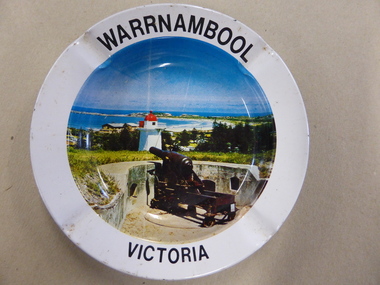
Ashtray, Mid 20th century
This is an ash tray sold to tourists as a souvenir of a visit to Warrnambool. It would have been relatively cheap to buy. Souvenirs such as this were mass-produced for the tourist market and a relevant photograph inserted on the base to suit the town or settlement where they were sold. As cigarette-smoking is no longer so socially acceptable, items such as this one are no longer sold as tourist souvenirs. This item is of interest as an example of the type of souvenir sold to tourists in Australia in the first half of the 20th century, probably in the 1940s or 1950s. It is of particular local interest because it contains a photograph of Warrnambool during that time. This is a souvenir tin ash tray circular in shape. It has a colour photograph of Warrnambool inserted into the base of the dish (Flagstaff Hill showing part of the fortifications, the Lower Lighthouse, a camping ground and Warrnambool Bay). The ash tray has three lips on the side of the dish for resting a cigarette. The base is gold-coloured and is slightly tarnished. ‘Warrnambool Victoria’ tourism in warrnambool -
 Kiewa Valley Historical Society
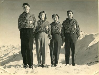
Photographs – Skippy St Elmo and other skiers – Set of 8 black and white photographs
... of the Falls Creek area, promoting local ski sports and tourism ...Skippy and Toni St Elmo were responsible for early developments at the Falls Creek resort and for promoting a love of skiing. They left Melbourne in 1945 and settled at Falls Creek and moved into the first building constructed of corrugated iron and timber at Falls Creek in 1946. They were Falls Creek’s first workers with Toni employed by the State Electricity Commission to record weather-related data up to the construction of the Kiewa Hydro-Electric Scheme. In 1957, Toni was involved in building the first rope tow called Nissen on the same route as the Summit Quad. He also established the Nissen Ski School with ski instructor Milan Kovacic and was involved in the building of the resort’s first ski club Bogong in 1949. Toni taught Skippy to ski and she practised on the High Plains where she and her husband lived. Skippy St Elmo won many ski races during the 1950’s and represented Australia in New Zealand.Skippy and Toni St Elmo were pioneers of the Falls Creek area, promoting local ski sports and tourism. The played an important role in opening up the Falls Creek area and developing its sporting potential by establishing the first ski school, ski lifts and early lodge facilities. Skippy and Toni St Elmo were honoured at the Alpine Village at Falls Creek on November 17 2006, with the spreading of their ashes at the place which played such an important part in both their lives.Set of 8 black and white photographs of Skippy St Elmo and other skiers 1. Skippy and 3 others in New Zealand 1951 2. Skippy and 5 others Falls Creek 1955 3. Cake celebrating 20 years of sport at Nissen Lodge 4. Skippy and friend outside Nissen Lodge 5. Skippy on the ski slopes 6. Skippy on the ski slopes 7. Albury Ski Club team New Zwealand 1957 8. The Bogong Ski Club 1950 Written on back of photos 1. Bob Howe Albury, Skippy New Zealand 1951 – 942H 2. Falls Creek 1955. Skippy St Elmo: H Devonassore; Margaret ?; ?; Tony St Elmo; Olive? 3. Written on cake Nissen Alpine Club. 20 years of sport. FRED 4. Skippy St Elmo 5. Skippy 6. Skippy 7. Bob Howe (Albury) Skippy New Zealand 1957. Albury Ski Club Team raced in NZ 8. The Bogong Ski club, Coronet Park, 1950. M Denham (Capt); B Wiltshire; R Roberts; Skippy St Elmo; Gwen Morris; J Frazer; J Smith; L Piera; Manager & Coach Toni St Elmo. J D Knowles Photographer Box 188, Queenstown. 744B falls creek, skiing, bogong high plains -
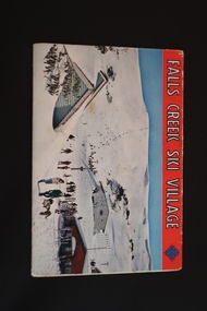 Kiewa Valley Historical Society
Souvenir Postcard Folder – Falls Creek Ski Village
Falls Creek Ski Resort developed during the construction of the Kiewa Hydro Electric Scheme built by the State Electricity Commission of Victoria. The first ski lodge was built in 1948 by workers from the scheme. The first lift, a rope tow, was built in 1951 and the first chairlift in Australia was constructed there in 1957. Falls Creek Post Office opened in 1958. Tourism was growing and being encouraged by local businesses.The souvenir postcard was produced by Mr S. K. Pearce a Mt Beauty businessman. It was a memento for skiers and visitors to the Falls Creek and Mt Beauty area to send to family and friends as a reminder of their visit to the region or to keep as a personal souvenir. It presented an excellent promotional opportunity for enterprising local businessmen to promote the area to skiers and tourists near and far. It also presents an excellent pictorial history of the Falls Creek area around the late 1950's and 1960's.Colour postcard folder (unused) containing 12 labelled colored photos of the Falls Creek ski area and surrounds with a blank 'page' entitled 'Correspondence' and another for the address.falls creek, skiing, snow sports, s. k. pearce, tourism, secv -
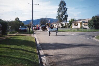
 Kiewa Valley Historical Society
Photographs – Set of 13 colour photographs of spectators preparing for the street parade to celebrate the first Official Hoppet race run at Falls Creek in 1991, 1991
... and spectators to the area which support tourism, local businesses ...In 1977 a group of Mount Beauty cross country skiers formed the Birkebeiner Nordic Ski Club. In 1979, a version of the famous Birkebeiner race, the first Australian Birkebeiner was held at Falls Creek. In June 1990 representatives from Australia put their case for a southern hemisphere race in the series. Following a trial event in 1990. Australia became the 12th member of Worldloppet in the winter of 1991, with the first Kangaroo Hoppet. In 1991 a parade and commemorative torch lighting ceremony were organised in Mt Beauty as part of the celebrations to mark the first official Kangaroo Hoppett with participation from local community groups and commercial organisations, the Chamber of Commerce, local government representatives and individuals.Kangaroo Hoppet caters to diverse interests by offering a 42km and 21km event. It also offers a 7km event that attracts skiers, ranging from elite juniors to parents, grandparents, babies and first time skiers. It is recognised on the world cross country ski race calendar. It brings large numbers of participants and spectators to the area which support tourism, local businesses and employment. The 2018 event will be the 28th Kangaroo Hoppet, with cross country skiers travelling from across the country and overseas to compete.Set of 13 colour photographs of spectators lining both sides of Holland St in preparation for the Kangaroo Hoppet street parade. Photographs show the original hospital buildings and street-scape of the early 1990’sNo markingskangaroo hoppet; cross country skiing; ski race; bogong high plains, mt beauty, parade -
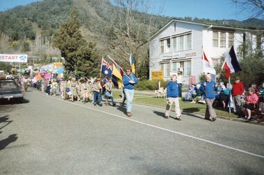
 Kiewa Valley Historical Society
Photographs – Set of 25 colour photographs of the street parade to celebrate the first Official Hoppet race run at Falls Creek in 1991, 1991
... and spectators to the area which support tourism, local businesses ...In 1977 a group of Mount Beauty cross country skiers formed the Birkebeiner Nordic Ski Club. In 1979, a version of the famous Birkebeiner race, the first Australian Birkebeiner was held at Falls Creek. In June 1990 representatives from Australia put their case for a southern hemisphere race in the series. Following a trial event in 1990. Australia became the 12th member of Worldloppet in the winter of 1991, with the first Kangaroo Hoppet. In 1991 a parade and commemorative torch lighting ceremony were organised in Mt Beauty as part of the celebrations to mark the first official Kangaroo Hoppett with participation from local community groups and commercial organisations, the Chamber of Commerce, local government representatives and individuals.Kangaroo Hoppet caters to diverse interests by offering a 42km and 21km event. It also offers a 7km event that attracts skiers, ranging from elite juniors to parents, grandparents, babies and first time skiers. It is recognised on the world cross country ski race calendar. It brings large numbers of participants and spectators to the area which support tourism, local businesses and employment. The 2018 event will be the 28th Kangaroo Hoppet, with cross country skiers travelling from across the country and overseas to compete.PHYSICAL: Set of 22 colour photographs of the street parade to celebrate the first Official Hoppet race run at Falls Creek in 1991. Participants from a range of local community groups are traveling along Kiewa Cres. Photos are taken near the corner of Maddison St 1&2 – Horseman & accordion player leading the parade Sign reads ‘Falls Creek The Happy Mountain’ 3-4 Birkbeioner Nordic Ski Club with Chinese Nordic ski representatives 5 & 6- Girl Guides & Brownies 7, 8 & 9- Mt Beauty Primary School & Netball team 10 & 11- UKV Calisthenics Club 12- Lawn Bowls Club 13- Junior Football Club 14- Mt Beauty High School Band (on Wodonga Timber & Hardware truck) 15, 16 17 & 18- Mt Beauty Kindergarten 19,20, 21 & 22- Local Community Vehicles including Community Transport and Fire Brigade 23 & 24- Mt Beauty High School Band 25- Fiat 500 Topolino Vintage Car No markingskangaroo hoppet; cross country skiing; ski race; bogong high plains, mt beauty, parade -
 Kiewa Valley Historical Society
Photographs – Set of 13 colour photographs of the street parade to celebrate the first Official Hoppet race run at Falls Creek in 1991, 1991
... and spectators to the area which support tourism, local businesses ...In 1977 a group of Mount Beauty cross country skiers formed the Birkebeiner Nordic Ski Club. In 1979, a version of the famous Birkebeiner race, the first Australian Birkebeiner was held at Falls Creek. In June 1990 representatives from Australia put their case for a southern hemisphere race in the series. Following a trial event in 1990. Australia became the 12th member of Worldloppet in the winter of 1991, with the first Kangaroo Hoppet. In 1991 a parade and commemorative torch lighting ceremony were organised in Mt Beauty as part of the celebrations to mark the first official Kangaroo Hoppett with participation from local community groups and commercial organisations, the Chamber of Commerce, local government representatives and individuals.Kangaroo Hoppet caters to diverse interests by offering a 42km and 21km event. It also offers a 7km event that attracts skiers, ranging from elite juniors to parents, grandparents, babies and first time skiers. It is recognised on the world cross country ski race calendar. It brings large numbers of participants and spectators to the area which support tourism, local businesses and employment. The 2018 event will be the 28th Kangaroo Hoppet, with cross country skiers travelling from across the country and overseas to compete.Set of 13 colour photographs of the street parade to celebrate the first Official Hoppet race run at Falls Creek in 1991. Participants were from a range of local community groups and local industry representatives. Photos were taken on Holland St. opposite the old hospital building. Following the parade, a market stalls were set up on the green outside the Community Centre on Holland St. as part of the Hoppet celebrations. 1 & 2- Boy Scouts and Cubs 3- UKV Lions Club 4 & 5- Local children representing the history and fauna of the High Plains 6- Ambulance Services 7, 8, 9 & 10 – Representatives and equipment from local forestry industry 11- Vintage truck by Vintage Charms Tours providing tours of the local area for visitors 12 & 13- Market stalls set up on the green outside the Community Centre on Holland St. as part of the Hoppet celebrations. kangaroo hoppet; ski race; cross country skiing; bogong high plains, mt beauty, parade, -
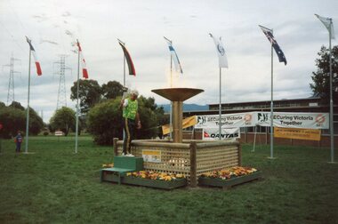 Kiewa Valley Historical Society
Photographs – Set of 21 colour photographs of the Opening Ceremony and commemorative torch lighting to celebrate the first Official Hoppet race run at Falls Creek in 1991, 1991
... and spectators to the area which support tourism, local businesses ...In 1977 a group of Mount Beauty cross country skiers formed the Birkebeiner Nordic Ski Club. In 1979, a version of the famous Birkebeiner race, the first Australian Birkebeiner was held at Falls Creek. In June 1990 representatives from Australia put their case for a southern hemisphere race in the series. Following a trial event in 1990. Australia became the 12th member of Worldloppet in the winter of 1991, with the first Kangaroo Hoppet. In 1991 a parade and commemorative torch lighting ceremony were organised in Mt Beauty as part of the celebrations to mark the first official Kangaroo Hoppett with participation from local community groups and commercial organisations, the Chamber of Commerce, local government representatives and individuals.Kangaroo Hoppet caters to diverse interests by offering a 42km and 21km event. It also offers a 7km event that attracts skiers, ranging from elite juniors to parents, grandparents, babies and first time skiers. It is recognised on the world cross country ski race calendar. It brings large numbers of participants and spectators to the area which support tourism, local businesses and employment. The 2018 event will be the 28th Kangaroo Hoppet, with cross country skiers travelling from across the country and overseas to compete.Set of 21 colour photographs of the Opening Ceremony and Commemorative Torch lighting to celebrate the first Official Hoppet race run at Falls Creek in 1991 1-3 - John Konrads (1956 Olympic Swimmer) lighting the Commemorative Torch with the original torch used at the 1956 Olympics at the MCG in Melbourne. 4-13 – Official opening ceremony and torch lighting by Liberal representative for Indi Mr Lou Leibermann. MC’d by Mr Ken Bell, representing the Chamber of Commerce 14 – Parachute fly over by Mr Ross Schult 15-18 – Photographs of the Multi National flags displayed in the commemorative garden in front of the SECV administration buildings. Flags represent the countries participating in the Kangaroo Hoppet. Snow-capped Mt Bogong in the background. 19-21 – Commemorative torch, erected by SECV to commemorate the first official Kangaroo Hoppet held at Falls Creek. No markingskangaroo hoppet; cross country skiing; ski race; bogong high plains; opening ceremony, mt beauty, parade -
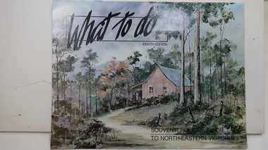 Kiewa Valley Historical Society
Brochure - Tourism, What to do - Souvenir Holiday Guide to North-Eastern Victoria
The Kiewa Valley has promoted itself as a tourist hot spot since the Kiewa Hydro Electric Scheme concluded. Mt Beauty began as a construction town and was to be sold off but tourism became promising so the SECV handed the town over to the Bright Shire, houses were sold and businesses commenced. From the early 1960s the town promoted itself and Falls Creek as a tourist destination. The Kiewa Valley Accommodation group combined with the local advertisers to publish this brochure.This brochure promotes tourism all year round promoting the local businesses enabling them to succeed. As tourism is the main industry in Mt Beauty and Falls Creek since the Kiewa Hydro Electric Scheme finished, this advertising is important. It is interesting to note the businesses - their type, their location and the comparison with those in the area now.19 black and white pages including maps and advertisements. Cover is a 'washed' color of a hut in the bush. The title is in black across the top and at the bottom right hand corner. The front cover is in 'landscape' format but the rest of the book is 'portrait'.mt beauty; falls creek; kiewa valley; tourism; north east victoria -
 Kiewa Valley Historical Society
Postcard Circa 1950, Snow Plough, Bogong High Plain,5,500 Feet Kiewa Hydro-Electric Project, Circa 1950
This postcard was produced in the 1950's for the tourist trade in the Kiewa Valley and Alpine region. It encompasses the period when the State of Victoria was pressured by the ever increasing demand by industry and its population for electricity supplies. Hydro electricity was seen as an untapped natural resource to quench this demand. The Victorian Alps and the rivers flowing into its valleys was ideal for the construction of the Kiewa Hydro Electricity Scheme. The late 1940's saw the development of this scheme and the changing of sections of alpine landscape is covered by this and other postcards/pictures (tourists, construction workers, and established rural populations). This period in time was before the established wildlife and forest/nature groups became political activist who changed legislative acts to protect the environment. This rural region (Kiewa Valley/alpine plains) was at most only significant to a smaller group of winter sports, summer hikers/horse riders and rural farmers/graziers. The numbers of tourists and the increase in the local resident population was boosted by the construction of the Hydro Electricity Scheme. This influx to the regional population resulted in a corresponding diversity in services and brought about an environment that responded to a growing level of tourists and thereby permitting this industry to grow more rapidly than it would have naturally. This postcard details an attraction to the "cleaner" method of providing electricity. This postcard was purchased in 1950 by a surveyor at Landford's Gap. This item is a black and white photograph(professional) of a panoramic view of a snow plough clearing the unsealed road in 1950.This postcard is on quality paper and the reproduction of the picture is of a high standard.For other "tourist" postcards see 0480 (A) -(F) for other photos of similar postcards. kiewa valley tourism, victorian alps, alternate energy supplies, alpine population growth, secv, snow plough -
 Kiewa Valley Historical Society
Postcard - Rocky Valley - Circa 1950, 1950
This postcard was produced in the 1950's for the tourist trade in the Kiewa Valley and Alpine region. It encompasses the period when the State of Victoria was pressured by the ever increasing demand by industry and its population for electricity supplies. Hydro electricity was seen as an untapped natural resource to quench this demand. The Victorian Alps and the rivers flowing into its valleys was ideal for the construction of the Kiewa Hydro Electricity Scheme. The late 1940's saw the development of this scheme and the changing of sections of alpine landscape is covered by this and other postcards/pictures (tourists, construction workers, and established rural populations). This period in time was before the established wildlife and forest/nature groups became political activist who changed legislative acts to protect the environment.This rural region (Kiewa Valley/alpine plains) was at most only significant to a smaller group of winter sports, summer hikers/horse riders and rural farmers/graziers. The numbers of tourists and the increase in the local resident population was boosted by the construction of the Hydro Electricity Scheme. This influx to the regional population resulted in a corresponding diversity in services and brought about an environment that responded to a growing level of tourists and thereby permitting this industry to grow more rapidly than it would have naturally. This postcard details an attraction to the "cleaner" method of providing electricity. This postcard was purchased in 1950 by a surveyor at Landford's Gap.This black and white photograph is from a Valentine's V2 Argus postcard. It is on a 200g/m paper density one side gloss. See also KVHS 0480 (A) to (L) for similar postcards. "ROCKY VALLEY FROM BOGONG HIGH PLAINS KIEWA HYDRO-ELECTRIC PROJECT" "V1"kiewa valley tourism, victorian alps, alternate energy supplies, alpine population growth, rocky valley, secv -
 Kiewa Valley Historical Society
Postcard - Junction Dam - Circa 1950, Circa 1950's
This postcard was produced in the 1950's for the tourist trade in the Kiewa Valley and Alpine region. It encompasses the period when the State of Victoria was pressured by the ever increasing demand by industry and its population for electricity supplies. Hydro electricity was seen as an untapped natural resource to quench this demand. The Victorian Alps and the rivers flowing into its valleys was ideal for the construction of the Kiewa Hydro Electricity Scheme. The late 1940's saw the development of this scheme and the changing of sections of alpine landscape is covered by this and other postcards/pictures (tourists, construction workers, and established rural populations). This period in time was before the established wildlife and forest/nature groups became political activist who changed legislative acts to protect the environment.This rural region (Kiewa Valley/alpine plains) was at most only significant to a smaller group of winter sports, summer hikers/horse riders and rural farmers/graziers. The numbers of tourists and the increase in the local resident population was boosted by the construction of the Hydro Electricity Scheme. This influx to the regional population resulted in a corresponding diversity in services and brought about an environment that responded to a growing level of tourists and thereby permitting this industry to grow more rapidly than it would have naturally. This postcard details an attraction to the "cleaner" method of providing electricity. This postcard was purchased in 1950 by a surveyor at Landford's Gap.This black and white photograph is a Valentine's postcard, from a V2 Argus photograph. It is on a 200g/m paper density with only the photo side gloss.Front "JUNCTION DAM & SPILLWAY, BOGONG KIEWA HYDRO-ELECTRIC PROJECT" on the flip side "VALENTINE'S POST CARD " "A GENUINE PHOTOGRAPH"kiewa valley tourism, victorian alps, alternate energy supplies, alpine population growth, junction dam, secv -
 Kiewa Valley Historical Society
Postcard - Junction Dam - Circa 1950, Circa 1950
This postcard was produced in the 1950's for the tourist trade in the Kiewa Valley and Alpine region. It encompasses the period when the State of Victoria was pressured by the ever increasing demand by industry and its population for electricity supplies. Hydro electricity was seen as an untapped natural resource to quench this demand. The Victorian Alps and the rivers flowing into its valleys was ideal for the construction of the Kiewa Hydro Electricity Scheme. The late 1940's saw the development of this scheme and the changing of sections of alpine landscape is covered by this and other postcards/pictures (tourists, construction workers, and established rural populations). This period in time was before the established wildlife and forest/nature groups became political activist who changed legislative acts to protect the environment.This rural region (Kiewa Valley/alpine plains) was at most only significant to a smaller group of winter sports, summer hikers/horse riders and rural farmers/graziers. The numbers of tourists and the increase in the local resident population was boosted by the construction of the Hydro Electricity Scheme. This influx to the regional population resulted in a corresponding diversity in services and brought about an environment that responded to a growing level of tourists and thereby permitting this industry to grow more rapidly than it would have naturally. This postcard details an attraction to the "cleaner" method of providing electricity. This postcard was purchased in 1950 by a surveyor at Landford's Gap.This black and white photograph on a Valentine's postcard is from a V2 Argus photograph. It is on a 200g/m paper density one side gloss only/. See 0480 (A) -(L) for other photos of similar postcards."JUNCTION DAM & SPILLWAY, LAKE GUY, BOGONG, KIEWA HYDRO-ELECTRIC PROJECT" "V5" on the flip side" VALENTINE'S POST CARD " "A GENUINE PHOTOGRAPH"kiewa valley tourism, victorian alps, alternate energy supplies, alpine population growth, junction dam, secv -
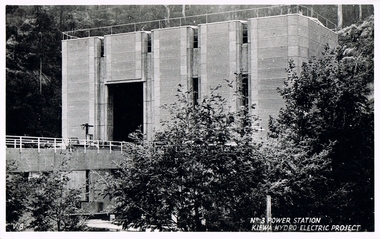 Kiewa Valley Historical Society
Postcard Circa 1950, No.3 Power Station Kiewa Hydro-electric Project "V.8", Circa 1950
This postcard was produced in the 1950's for the tourist trade in the Kiewa Valley and Alpine region. It encompasses the period when the State of Victoria was pressured by the ever increasing demand by industry and its population for electricity supplies. Hydro electricity was seen as an untapped natural resource to quench this demand. The Victorian Alps and the rivers flowing into its valleys was ideal for the construction of the Kiewa Hydro Electricity Scheme. The late 1940's saw the development of this scheme and the changing of sections of alpine landscape is covered by this and other postcards/pictures (tourists, construction workers, and established rural populations). This period in time was before the established wildlife and forest/nature groups became political activist who changed legislative acts to protect the environment.This rural region (Kiewa Valley/alpine plains) was at most only significant to a smaller group of winter sports, summer hikers/horse riders and rural farmers/graziers. The numbers of tourists and the increase in the local resident population was boosted by the construction of the Hydro Electricity Scheme. This influx to the regional population resulted in a corresponding diversity in services and brought about an environment that responded to a growing level of tourists and thereby permitting this industry to grow more rapidly than it would have naturally. This postcard details an attraction to the "cleaner" method of providing electricity. This postcard was purchased in 1950 by a surveyor at Landford's Gap.This black and white photograph from a Valentine's postcard is from a V2 Argus photograph postcard. It is on a 200g/m paper density photo side gloss. See 0480 (A) - (K) for other photos of similar postcards."No.3 POWER STATION KIEWA HYDRO ELECTRIC PROJECT" "V8"kiewa valley tourism, victorian alps, alternate energy supplies, alpine population growth, secv