Showing 198 items
matching maps of germany
-
 Bendigo Military Museum
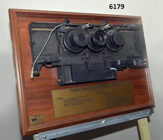
Plaque - Mounted Klimsch Commodore Cartographic Camera Lenses, WYCOMBE Constructions Pty Ltd, 1997
These are the Lenses from the Klimsch Commodore Cartographic Camera that was located in Lithographic Squadron at the Army Survey Regiment, Fortuna, Bendigo. The KLIMSCH Commodore camera was originally introduced to the Survey Regiment in 1953 and was the largest in the Southern Hemisphere. It was replaced with a new model of the same size in 1977. These lenses are from this new model. The new model with its computer-based interface provided productivity gains with improved speed and its consistent results led to less wastage in time and materials. Its variomat lens system provided improved retention of map feature linear weights during the camera reduction process. The camera which was specially made for the Australian Army in Germany was fully automatic and power operated. It was claimed to be one of the biggest automatic cameras of its type in the world. It was made to the specifications of the Royal Australian Army Survey Corps to assist in the production of the very high standard maps for the Australian Army. THIS KLIMSCH COMMODORE CARTOGRAPHIC CAMERA was in operation 1977 - 1997". It was a Precision Darkroom Camera especially suited for Cartographic Reproduction of Line, Continous Tone, Halftone and Colour Separation. Reproduction of Negatives and Positives from a variety of Reflection or Transmission Originals. Its characteristics were: Maximum Negative Size 1.27m sq, Copy Holder (Vacuum) 2m sq, Maximum Enlargement 400%, Maximum Reduction 13%, Automatic 60, 90 and 120cm Focal Length Lens, Transmission or Reflection Originals, Pulsed Xenon, Photo Flood or Fluorescent Tube Light Source, Maximum Reflection Original 1.3m x 1.85m, Maximum Transmission Original 1.3m x 1.85m, Exposure Light Monitoring System." The camera was superseded by computerized image manipulation software associated with the Automap system. These significant and extremely high-quality Lenses were retrieved by WYCOMBE Constructions Pty Ltd during the demolishment of the camera in 1997 and then mounted on a display board. See also Item 6189.4P for more photographs of the camera.Lenses from the Klimsch Commodore Cartographic Camera mounted on a very heavy timber display board. The display board contains an engraved plate that describes the technical characteristics of the camera."KLIMSCH COMMODORE CARTOGRAPHIC CAMERA 1977 - 1997", "FUNCTION: Precision Darkroom Camera especially suited for Cartographic Reproduction of Line, Continous Tone, Halftone and Colour Separation. Reproduction of Negatives and Positives from a variety of Reflection or Transmission Originals." "CHARACTERISTICS: Maximum Neg Size 1.27m sq, Copy Holder 2m sq, Maximum Enlargement 400%, Maximum Reduction 13%, Automatic 60, 90, 120cm Focal Length Lens, Transmission or Reflection Originals, Pulsed Xenon, Photo Flood or Fluorescent Tube Light Source, Maximum Reflection Original 1.3m x 1.85m, Maximum Transmission Original 1.3m x 1.85m, Exposure Light Monitoring System." royal australian survey corps, rasvy, fortuna, army survey regiment, army svy regt, asr, litho -
 Bendigo Military Museum
Photograph - Photographic Technicians performing tasks at the Army Headquarters Survey Regiment, c1960s
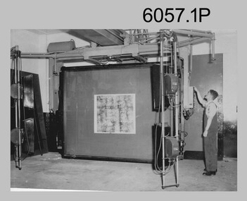
These eight photographs were most likely taken in the 1960s in Lithographic Squadron at the Army Headquarters Survey Regiment, Fortuna, Bendigo. Although Photo .1P is not annotated the remainder have the name of the technicians written on the back. The equipment operated by the technicians is the KLIMCH Commodore camera. The main tasks undertaken by the technicians were most likely enlargements and reductions of map reproduction material. The KLIMSCH Commodore camera was introduced in 1953 and was the largest in the Southern Hemisphere. It was replaced with a new model of the same size in 1979. The new model with its computer-based interface provided productivity gains with improved speed and its consistent results led to less wastage in time and materials. Its variomat lens system provided improved retention of map feature linear weights during the camera reduction process. The typed description pasted on the back of photo .5P states “Cpl R. MacKenzie of Bentley, Perth (WA) of the AHQ Survey Regt, located at “Fortuna”, Bendigo, (Vic). Has been in the Army for 5 years. He removes the lens cap from the 70 inch F16 lens of the giant KLIMSCH camera used in map making for the Army. The camera which was specially made for the Army in Germany is fully automatic and power operated. It is claimed to be one of the biggest automatic cameras of its type in the world. It was made to the specifications of the Aust Army Survey Corps to assist in the production of the very high standard maps for the Army. The AHQ Survey Regt also assists Commonwealth and other Govt departments in the printing of maps required other than for Army needs. The KLIMSCH camera is used for cartographic mapping photography.” This is a set of photographs of technicians operating photographic reproduction equipment at the Army Headquarters Survey Regiment, Bendigo c1960s. The photographs were printed on photographic paper and are part of the Army Survey Regiment’s Collection. The photographs were scanned at 300 dpi. .1) - Photo, black & white, c1960s, Les ‘Snow’ Taylor, Lithographic Squadron .2) - Photo, black & white, c1960s, Les ‘Snow’ Taylor, Lithographic Squadron .3) - Photo, black & white, c1960s, John Rolfe, Lithographic Squadron .4) - Photo, black & white, c1960s, John Rolfe, Lithographic Squadron .5) - Photo, black & white, c1960s, CPL R. MacKenzie, Lithographic Squadron .6) - Photo, black & white, c1960s, unidentified, Lithographic Squadron .7) - Photo, black & white, c1960s, George Graham, Lithographic Squadron .8) - Photo, black & white, c1960s, L to R: Bill Snelson, George Graham, Lithographic Squadron.1P – no annotation .2 to .4 – personnel names (less rank) annotated on back. .5 – name and rank annotated on back, with detailed typed description .6 to .8 – personnel names (less rank) annotated on back. royal australian survey corps, rasvy, army survey regiment, army svy regt, fortuna, asr, litho -
 Bendigo Military Museum
Photograph - Ultra-MAN-III Printing Presses operating at the Army Survey Regiment, c1970s to c1980s
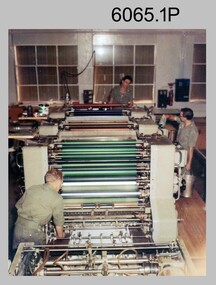
... Printing Presses were made in Germany at a standard map size format... Printing Presses were made in Germany at a standard map size format ...These ten photographs of the Ultra-MAN-III Printing Presses were probably taken circa 1970s to 1980s in Lithographic Squadron at the Army Survey Regiment, Fortuna, Bendigo. Although most photos are not annotated except for photos .1, .3P, .6P; most personnel are positively identified. The two Ultra-MAN-III Printing Presses were made in Germany at a standard map size format and introduced in June 1962 as a two-colour offset press with improved safety features. With an upgrade to a third colour deck in 1968, productivity greatly improved as the two presses could print a five colour standard topographic map in two passes, rather than the three passes before their upgrade. They were replaced with a single Heidelberg Speedmaster 102 five colour Printing Press in 1990. c1970s to c1980s.This is a set of photographs of the Ultra-MAN-III Printing Press operational at the Army Survey Regiment, Bendigo c1970s to c1980s. The photographs were printed on photographic paper and are part of the Army Survey Regiment’s Collection. The photographs were scanned at 300 dpi. .1) - Photo, colour, c1970s, L to R: Morgan, Mulqueen, Cook, Lithographic Squadron .2) - Photo, black & white, c1980s, unidentified, Lithographic Squadron .3) - Photo, black & white, c1980s, Ken Slater, Lithographic Squadron .4) - Photo, black & white, c1980s, L to R: Kim Reynolds, Terry Winzar, Lithographic Squadron .5) - Photo, black & white, c1980s, Lithographic Squadron .6) - Photo, black & white, c1980s, L to R: Steve Egan, unidentified, Jim Cook, Lithographic Squadron .7) - Photo, black & white, c1980s, Kim Reynolds, Lithographic Squadron .8) - Photo, black & white, c1980s, Roy Hicks, Lithographic Squadron .9) - Photo, black & white, c1980s, Lithographic Squadron .10) - Photo, black & white, c1980s, Colin Yeats, Lithographic Squadron.1, .3P, .6P – personnel annotated 2P, .4P to .5P, .76P to .10P – no annotation royal australian survey corps, rasvy, army survey regiment, army svy regt, fortuna, asr, printing, litho -
 Bendigo Military Museum
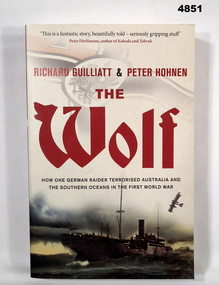
Book - BOOK, WW1 NAVAL HISTORY, GUILLIATT Richard & HOHNEN Peter, " THE WOLF', 2009
"THE WOLF' How one German raider terrorised Australia and the Southern Oceans in the First World War.Soft cover book. Soft cover - cardboard, red and black print on front, spine and back. Cover - colour illustrated - front - top German symbol, bottom, ship at sea. Back - sepia photograph - sailor and girl. 366 pages - cut, plain, off white paper. Illustrated black and white photographs and maps.Nilbook, ww1, naval operations -
 Bendigo Military Museum
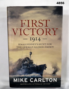
Book - BOOK, Naval Operations Australia & Germany WW1, CARLTON Mike, "First Victory 1914", 2013
"FIRST VICTORY 1914 - HMAS SYDNEY'S HUNT FOR THE GERMAN RAIDER EMDEN."Hardcover Book with Dust cover. Hardcover - cardboard, red buckram, silver print on spine. Dust cover - paper: Red gold and white print on front, spine and back. Dust cover, colour illustrations - front copy of painting of HMAS Sydney in battle with SMS Emden by the late Phil BELBIN. 467 pages, cut, plain, off white paper, illustrated - black and white, sepia and colour photographs, paintings, diagrams and maps. End papers and flyleaf - front and back - coloured green.books, naval operations, ww1, australia, germany -
 Federation University Historical Collection
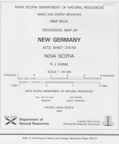
Map - Geological, New Germany Nova Scotia, Geological Map 93-01
... New Germany Nova Scotia, Geological Map 93-01... Germany Nova Scotia, Geological Map 93-01 Map - Geological ... -
 Lara RSL Sub Branch
Book, The Greatest Raid of All Author C.E. Lucas Phillips, 1958 Companion Book Club
Historical WWII recount of the successful raid on the battleship dock at St. Nasiere. This was an action which could only be attempted precisely because it must appear to the enemy, to be absolutely impossible to undertake and for this reason alone it required courage and determination of a quite unusual order to carry out. The operation had been planned in great detail. Once the forces were committed each individual small ship and little group of soldiers had to fight it out by their own initiative in communication from the home front.A naval deployment during WWII in Normandy.Hardcover blue with red swatch, gold trim and gold writing. Photographs, Maps, Illustrations.Foreword by Admiral of the Fleet, the Earl of Mountbatten of Burma KG. " A deed of glory intimately involved in high strategy" Winston Churchill An original Companion Bookclub advertisement leaflet is tucked inside the back cover.st.nasiere raid, german informants, normandie dock, mountbatten, c.e. lucasphillips, robert ryder, the dock busters, caissons, the jaguar, navigation -
 Lara RSL Sub Branch
Book, The Memoirs of Field M- Marshal Montgomery Author Montgomery of Alamein K.G, 1960
London, Europe and Dardenelles. Personal recount of boyhood in England to Military service and death.WWII personal recount. Statistics, Maps, Illustrations, Photographs. Letters .An autobiography. " A blessed companion is a book" by Jerrold Inside front pagewwii, whitehall, 8th army, london, el alamein, dardenelles, europe, unity of the west, palestine, germany, russia, high command, german surrender, italy, sicily, normandy, dunkirk, docterine of command, arnhem -
 Lara RSL Sub Branch
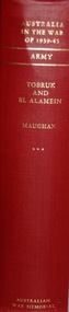
Book, Australia in the War of 1939-1945 Tobruk and El Alamein ARMY Author Barton Maughan, First Published 1966
Australia in the War 1939 - 1945 From March 1941 - December 1942 Historical record part of a seriesAustralia in the War of 1939-1945 - Tobruk and El Alamein Maps, illustrations, photographsAustralian War Memorialtobruk, el alamein, army, wwii, palestine, lebanon, german invasion of greece and yugoslavia, bismark, malaya, pearl harbour, darwin, crete, churchill, faddon, curtin -
 Lara RSL Sub Branch
Book, Australia in the War of 1939-1945 - Air War Against Germany and Italy 1939-1943. AIR Author John Herington, First published 1954
Australian contribution to air fighting against Germany and Italy with Australia being a small force against the larger, stronger air forces. The smaller Australian Airmen were merged into the Royal Air Force.Historical record of the AIR effort 1939-1943Australia in the War of 1939-1945 - Air War Against Germany and Italy 1939-1943 Illustrations, Maps, Diagrams and Graphs, MapsAustralian War Memorialgermany, italy, the battle of britain, syria, western desert, fighter squadrons in 1941, bomber command 1941, radar bombing, air war, tunisia, pathfinder raids, invasion of sicily, night fighters -
 Lara RSL Sub Branch
Book, Official History of Australia in the War of 1914-18 - Volume V - The AIF in France 1918 Official History of Australia in the War of 1914-18. Author C.E.W. Bean Volume V, Third Edition1938
This volume narrates the part played by the Australian Corps in the barring of the German advance upon Amiens in 1918. It also endeavours to explain the change of outlook which enhanced the spirit and performance of Australian soldiers throughout the last year of the war. The main subject necessarily involves a more than incidental reference to the performance of the British Army in the greatest battle ever waged.During the main German offensive 1918Official History of Australia in the War of 1914-18 - Volume V - The AIF in France 1918 Hardcover cardboard, Illustrations, Maps, Chronologymessines, ludenorff strike, australian corp, amiens, dernancourt, battle of lys, villers bretonneux, hangard wood, somme, st. quentin, fonquebillers, lancashire fusiliers, 53rd battalion, 35th battalion, sir henry wilson, arras, battle of hazebrouck, kemmel ridge -
 Lara RSL Sub Branch
Book, Official History of Australia in the War of 1914-18 - Volume VI - The AIF in France 1918 Author C.E.W. Bean. The AIF in France May 1918- the Armistice, Published 1942
This volume deals with those months in which the first World War turned against the German Army on the western front, and shows in detail how, in the crucial Amiens sector that change was brought about. The completion of the story of the final offensive in 1918.An account of the conclusion of the first world war with Germany being defeated and surrendering.Official History of Australia in the War of 1914-18 - Volume VI - The AIF in France 1918. Hardcover cardboard. Maps, diagrams, illustrations, chronologygerman surrender, battle of aisne 1918, monash succeeds, battle of hamel, amiens, armistice, peace treaty signed, battle of montbrehain -
 Lara RSL Sub Branch
Book, Official History of Australia in the War of 1914-18 - Volume VIII - Australian Flying Corps Author F.M.Cutlack. 6th edition, 1938
Historical record of the Australian Flying Corps from diaries of airmen and the Australian War Museum. No. 1 Squadron - private diaries of Lt. Colonel R. Williams. No, 2,3,and 4 Squadrons.Record of Australian Air Corps using personal diaries.Official History of Australia in the War of 1914-18 - Volume VIII - Australian Flying Corps. Maps and Illustrations Sixth editionmesopotamia, world war one, squadrons 1,2,3 and 4, private diaries, german offensive, air warfare, turkish retreat, gaza, mezzines ridge, somme, types of fighting aircraft -
 Lara RSL Sub Branch
Book, Official History of Australia in the War of 1914-18 - Volume IX - The Royal Australian Navy Author A.W. Jose, 1937 fifth edition
Historically depicts the operations of the Royal Australian Navy duty occasioning navy vessels in addition to the drudgery of patrol work and the search for enemy vessels. Working in isolation because of being a vessel that is under their own control.This volume of the War Histories is concerned with the doings of an infant navy.Official History of Australia in the War of 1914-18 - Volume IX - The Royal Australian Navy Maps and Illustrationsgerman colonies, samoa, nauru, western pacific, africa, dardenelles, north atlantic, european waters, raiders and minefields, ran brigade, hospital ships, transports and dockyards, radio-telegraphy, suvla bay, sinking of the cumberland, german cruiser squadron, cocos, sydney-emden action, north sea -
 Lara RSL Sub Branch
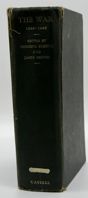
Book, The War 1939-1945 Edited by Desmond Flower and James Reeves Dedicated to the 30,000,000 dead, First Published 1960
A documentary conspectus of the worst war in history beginning at the German invasion of Poland 1939 and ending with the last Japanese surrenders in September - October 1945. This book is an attempt to put together a chronicle of how it actually felt to be alive, to see, to hear, to smell, to feel the war first hand.The War 1939-1945 - Printed 1960 Dark blue cover with ware and tear around the edges MapsDate stamps from HMAS Albatross library wwii, phony war, winter war, norway -
 Bendigo Military Museum
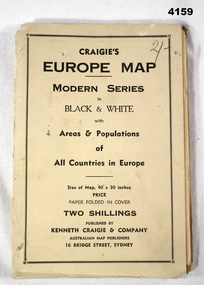
Map - MAP of EUROPE, Craigie"s Europe Map, 1939
The map features the areas and populations of all European countries as per 1939. Part of the collection re Frederick Gardner Davey DFC No 410533 RAAF. Refer Cat No 3536P for his service details.Folded map in black and white. Coloured British and German flags are pinned to countries on the map.On the front cover in pencil, “2/-“. (2 schillings)maps, europe -
 Bendigo Military Museum
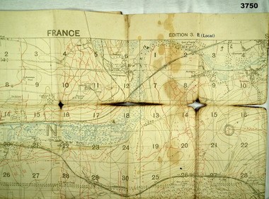
Map - TRENCH MAP WW1, 1918
Areas covered on this map “Corbie, Villers Brettoneux, Hangard, Blangy and Tronville Wood, River Somme”. Item re William Alexander No 502 AIF. Refer Cat No 3746.3 for his service details.Trench map, France, Edition 3B, trenches corrected to 7.7.1918, German trenches in red, British in blue, scale 1:20,000.map, france, trench -
 Bendigo Military Museum
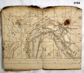
Map - TRENCH MAP WW1, 1918
Areas covered on this map, “Ribemont, Morlancourt, Dernacourt, Fricourt, Mericourt, Saily Le Sec” Item re William Alexander No 502 AIF. Refer Cat No 3746.3 for his service details.Trench map, France, Edition 2 E, sheet 62D N.E, scale 1:20,000, trenches corrected to 28.5.1918, German trenches in red, British in blue.map, france, trench -
 Bendigo Military Museum
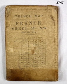
Map - TRENCH MAP WW1, 1917
Main Australian areas on this map include “Grevillers, Bapaume and Fremicourt” Item re W.A Alexander No 502 AIF. Refer Cat No 3746.3 for his service details.Trench map, France, sheet No 57N.W. Edition6A, scale 1:20,000, trenches corrected to 7.2.1917, German trenches in red, on rear glossary of terms French to English.map, trench, france -
 Bendigo Military Museum
Map - MAPS FRANCE WW1, All 1918
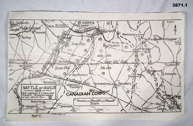
(.2) Areas on map relate to : The Hindenburg line on the left, from the top, Bony to Bellicourt to Bellenglise, Estrees to Brancourt. (.3) The River Somme runs through from top corner left bottom corner right. Main areas are Belloy, Picquigny, Bertangles, Montieres. The map finishes just short of “Amiens” Items in the collection relating to F.A.W Hutson No 3539 AIF. refer Cat No 922 for his service history.(.1) Map on paper showing the “Battle of August 1918”, Map C, The Advance to “Lions & Proyart”. (.2) Trench map, gauze lined, sheet 62B N.W, trenches corrected to 8.2.1918, German trenches in blue, scale 1:20,000, France. (.3) Ordnance survey map, May 1918, France, Edition 1, sheet 62 E N.E, scale 1:20,000, a canal and river runs through the centre(.2) On rear hand written “62 B N.W” (.3) On rear hand written “D.M.F 62 E N.E”august 1918, maps, somme -
 Bendigo Military Museum
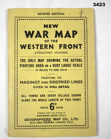
Map - WAR MAP WESTERN FRONT, Geographer's Map Co Ltd, c.WWII
... , France to Karlsruhe, Germany. Map WAR MAP WESTERN FRONT ...Folded map fixed into yellow cardboard folder with black printing. Map covers battle areas late in WWII of Maginot Line & Siegfried Line from Metz, France to Karlsruhe, Germany.On cover in black print: “Second Edition. New War Map of the Western Front”map, seigfreid, maginot -
 Bendigo Military Museum
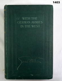
Book, Sven Hedin, With the German Armies in the West
... , light green print. 402 pages, illustrated black & white maps ...Green buckram hard cover, light green print. 402 pages, illustrated black & white maps / drawings. books, biography, military history -
 Bendigo Military Museum
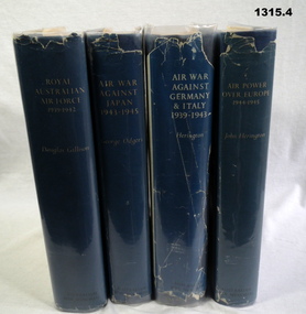
Book - BOOKS, 1) Douglas Gillison et al, Australians in the War of 1939-1945. Series Three. Air, 1) 1962; .2) 1957; .3) 1954; .4) 1963
Mid blue buckram hard covers with blue plastic covered dust jackets. Titles on front covers & spines except Vol III due to front of dust jacket missing. Illustrated with black & white photos & maps. .1) Vol I Royal Australian Air Force 1939-1942, 786 pages .2) Vol II Air War Against Japan 1939-1945, 533 pages .3) Vol III Air War Against Germany & Italy 1939-1943, 731 pages .4) Vol IV Air Power Over Europe 1944-1945, 539 pagesbooks, military history - airforce -
 Bendigo Military Museum
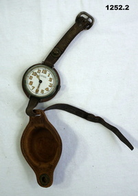
Accessory - WRISTWATCH, pre WWI
The watch was owned by Jack Grinton No 1043, 38th Batt AIF 1916-19. Part of the Grinton collection which included hundreds of negatives and developed photos that he took during the Great War. Refer Cat No 1280 for service details. Refer 1317P, 1320P. .1 Wristwatch and jewels, Swiss made. Face is white with gold numbering. .2 Leather watch cover in 3 sections: top and bottom straps, watch backing and cover with metal press stud. .2 Inside top cover: "JWG", impressed map of Australia with lettering "DON" and underneath "trade mark registered". Metal stud on wrist strap has "Made in Germany"horology-watches, handcrafts-leatherwork, metalwork, grinton -
 Bendigo Military Museum
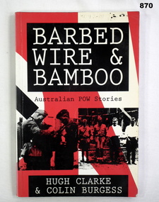
Book, Allen & Unwin Pty Ltd, Barbed Wire & Bamboo, 1992
Book, soft cover. Main background on front cover is red & white. Title is white ink on black background. Bottom half has 2 images showing Germans searching a British soldier & 4 Japanese guards lined up. 159 pages, illustrations, some maps & drawings.Donated by Bgo YMCA Stamped on 2nd fly leaf: Thailand Hellfire Pass ex POW Projectbooks, military, history, imprisonment -
 Bendigo Military Museum
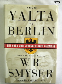
Book, From Yalta to Berlin. The Cold War Struggle over Germany, 1999
Hard cover, plain light grey, title in gold on spine, dust jacket illustration of seaman. Emblem (black eagle on yellow shield, subtitle in white on red. 465 pages some with photos and maps. Hand written on fly leaf "Donated by Bgo "y" mens club". books-military-history, cold war -
 Frankston RSL Sub Branch
Pocketbook, Souvenir, Taschenbuch Groß-Deutschland, Geschichtstafel, Deutschlands Wehrmacht, Weltatlas, 31 August, 1941
provenance unknownSmall, soft cover, pocketbook presumably souvenired from a German soldier during the latter stages of World War 2. The pocketbook is of the type originally issued by the German military and was printed in August 1941, edited by Georg Westermann, Braunschweig. The book has a red coloured cover with black printing and contains 48 pages. Pages are printed in black, the maps are printed in colour. The pocketbook is in good condition, some pages have tears and the cover is scuffed. The pocket book title translates as "Paperback Greater Germany, History Chart, Germany's Wehrmacht, World Atlas" and is a collection of information about the German Reich, German military units and insignia and world maps, 1942 calendar, etc. The original owner has made markings on some maps and has made notes.The front cover is printed in black ink with the following "Taschenbuch Groß-Deutschland, Geschichtstafel, Deutschlands Wehrmacht, Weltatlas" -
 Flagstaff Hill Maritime Museum and Village
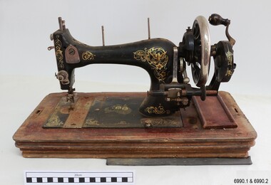
Domestic object - Sewing Machine, 1890s to 1911
This machine was made in Baden, Germany, for the Ward Brothers of Melbourne, who imported machines from various manufacturers and had them branded with their Ward Brothers decals. This machine is most likely dated before 1911, when the Ward Brothers became two separate businesses, as one of the decals appears to have been deliberately removed. The case is made in an attractive design and the machine itself has decorations that are pleasant to the eye. Even the metal cover of the folding handle has a swirling design on it. The machine has the added bonus of a ruler along the front base. Many sewing machine manufacturers in Germany produced their machines specifically for export. A company could mass-produce its machines and give the same product several different brand names, according to their overseas buyers. There was a huge market for domestic machines as it enabled tailored clothing to be made in households at a fraction of the retail prices. Ward Brothers began in Australia in the late 1890s and early sewing machines sold by them had the three brothers on their decals. In 1911 the brothers divided into two separate firms, one operating on his own, the other two remaining together, and all still operating in Melbourne and at first still using the name Ward Brothers.This sewing machine is one of two hand-operated Ward Brothers machines in our collection that were made in Baden, Germany, and the only one that has had the three Ward Brothers on its decal, and that has front and rear slide plates. This machine represents the early domestic market for sewing machines, making it possible for the everyday homemaker to produce fashionable garments and linen ware that was affordable. The owner of this machine could work at more than one location as it was portable and did not require a large space to set up. The machine is associated with the well-known Ward Brothers of Melbourne, who sold imported sewing machines that were branded with their own name. Sewing machine, hand operated, in wooden case. The machine is painted black with gold decals, and front and rear slide plates. The wooden base of the machine has an inlaid ruler. The case has curved sides and shaped ends, decorative woodwork on corners, an inlaid diamond pattern on top, and a folding metal handle. Accessories are included. The decals include doves, inscriptions and swirls, and there is a map of Australia with two portraits of men. The machine was made in Baden, Germany, for Ward Brothers, Melbourne. Images: Map of Australia with States marked, and with portraits of two men. [A portrait-sized area on the left of the men has had the image removed.] Text in printed script: "Specially / Made in Baden" "WARD BROTHERS / MELBOURNE" " with a Logo is a map of Australia,flagstaff hill, warrnambool, great ocean road, sewing machine, hand operated, pre-1911, domestic sewing, homemade clothing, fashion, ward brothers, made in germany, baden, front and rear slide plates, crank handle, hand crank sewing machine -
 Warrnambool RSL Sub Branch
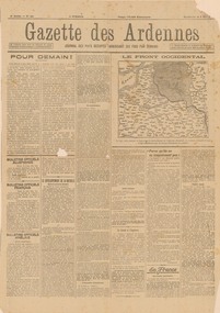
GAZETTE DES ARDENNES, 5 MAY 1918. 4th year, No 621, German newspaper, in French, for the occupied territories, printed in Charleroi, Belgium. (TRANSLATED IN PART by W.Barber), 5 May 1918
Original, single page propaganda broadsheet, collected by Bob Snape, when he was working as Confidential Clerk to General Sir John Monash, with Australia Corps HQ, in Belgium, late 1918. Yellowed with age, but despite some tears along the folds and a hole the size of a 20 cent piece, it is a good legible document with a front-line mapsnape collection -
 Federation University Historical Collection
Book - Register, Ballarat School of Mines Library Register of Books, 1870-1896, 1870-1896
The listing of books in the Ballarat School of Mines library begins with No 1 and ends at No 1465. This book is identical to Library Catalogue No 00007, but isonly numbered to No. 921. Redmond Barry, Robert Broigh Smyth, Ferdinandy Von Mueller, the Victorian Geolofical Survey and many local illuminaries donated to the Ballarat School of Mines. Black cloth covered exercise book with handwritten lists of books in the Ballarat School of Mines Library dating from 1870 to 1896. The pages have been divided into columns with the following headings: Reg. No; Title; Author; Vol.; Issue; Donor, Receipt. Some of the books are as follows: 1. Memoirs of Geological Survey of Great Britain, Vol 1., 1846, Donated by Her Majesty's Government, 16/03/1870 19. Prospectus of the School of Mines, 1869, Donated by Her Majesty's Government, 16/03/1870 44. The Steam Engine, Rankine, purchased, 09/03/1871 72. Melbourne University Calendar, 1859-1860, donated by Sir Redmond Barry, 14/04/1871 85. Maps of County of Anglesey, donated by Minister of Mines, 23/05/1871 107. Electric Telegraph, R. Sabine, purchased, June 1874 356. Organic Constituents of Plants and Vegetable Substances, Dr. G.C. Willstein, donated by Ferdinand Von Mueller 375. The native Plants of Victoria Succinctly Defined, Baron Von Mueller, purchased, 1879 569. Platur's Manual of Qual and Quan Analysis with the blowpipe, donated by Henry Sutton, May 1884 738. German Bible, donated by R. J. Litton, 21.05.1886 802. Essays of Addison, J.R. Green, 18/06/1887, donated by Bella Guerin 803. Rec De Planches Dur Les sciences Les Arts Liberaux et les Arts Mechaniques, Vol VI, 1875, Donated by Theo William, 01/07/1887 Excel spreadsheet attached (incomplete)ballarat school of mines, library, books, ballarat school of mines library, william laplau, dr bunce, james oddie, bella guerin, j.f. usher, r.m. sergeant, redmond barry, robert brough smyth, cosmo newbery, john noble wilson, joseph flude, commissioner of patents, henry sutton, w.n. wooster, theophilus taylor, rivett henry bland, ferdinand von mueller, c.c. shoppee, william luplau, ferdinand krause, william wooster