Showing 323 items
matching mine sections
-
 Bendigo Historical Society Inc.
Document - MCCOLL, RANKIN AND STANISTREET COLLECTION: PLAN OF AREA LEASE 10425, 10733 AND 10734, 1934
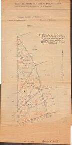
... section 5 (1) of the Mines Act 1928 to enter upon and occupy... for the Minister of Mines Authority under section 5 (1) of the Mines Act ...Plan of area applied for on lease No 10425, 10733 and 10734. Applied for by Mr. R.A. Rankin. Plan shows Marong Road, state school site ; leases held by H.E. Kronk, Francis Gramann; T. Wearne; C.E. Foggitt; A. Pitcher, Crown land and Aur. licences also marked. Lease numbers marked on plan. Map signed on bottom by Garnet G. Birch on 26.11.1934. On top Rh side in black pen " applications for the Minister of Mines Authority under section 5 (1) of the Mines Act 1928 to enter upon and occupy for mining purposes such portion of allotments lodged on 19/2/35'gold, mining, lease, mining, leases, kronk, garnet g. birch -
 Bendigo Historical Society Inc.
Book - MINING REPORTS - THE CONFIDENCE GROUP OF MINES BULLETIN NO 41
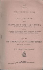
... and Sections by H S Whitelaw, Field Geologist, dated 1918. Mines... and sections of the Confidence Extended Mine on the Garden Gully Line ...Light brown covered booklet 'Bulletins of the Geological Survey of Victoria issued by W Dickson, Secretary for Mines, Under the Authority of the Hon. S Barnes M L A Minister of Mines. No 41 The Confidence Group of Mines, Bendigo with Plans and Sections by H S Whitelaw, Field Geologist, dated 1918. Mines mentioned are: Confidence Extended Mine, Confidence Tribute Company and the Central Windmill Hill Mine. Mentioned in the report are crushings and gold yield, details of levels, names of leases along the reef. Extracts from Mine Manager's Half-yearly Reports, 1878-1915 of tons crushed and gold yield. Plans and sections of the Confidence Extended Mine on the Garden Gully Line of Reefs are: Plate I General Plan of All Levels, Plans of Levels Plate No II, Plans of Levels Plate No III, Transverse Section Plate No IV, Longitudinal Section Plate No V, and Central Windmill Hill Mine Transverse Section Plate No VI. Plates signed by H S Whitelaw 17 & 18/6/16 and 20/7/16. Booklet if part of the Albert Richardson Collection. book, bendigo, mining reports, mining reports, the confidence group of mines bulletin no 41, confidence extended mine, confidence tribute company, central windmill hill mine, department of mines, bulletins of the geological survey of victoria, w dickson, the hon s barnes, h s whitelaw, h j green, mr robert eddy, mr w h cundy, j foster, c j thompson -
 Bendigo Historical Society Inc.
Model - MINERS' SAFETY CAGE MODEL
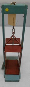
... on wooden stand to simulate a mine shaft. Cage section is painted... on wooden stand to simulate a mine shaft. Cage section is painted ...Model of miners' cage with safety brake system, mounted on wooden stand to simulate a mine shaft. Cage section is painted red, timber support and base aqua. Cage is suspended from wooden support by thin wire attached to top section of cage to demonstrate its position in a mineshaft and the operation of the safety brake system. Small metal crutch levers on side of cage gripping wooden guides. When tension ceases in rope a pair of crutch levers grab strongly onto the wooden guide strips which run down the sides of a vertical shaft. Safety cages were discussed in "Safety Mining Cages. Report of the Board of Enquiry on Safety Cages 1878-9; together with proceedings of the Board and Appendices". https://www.parliament.vic.gov.au/papers/govpub/VPARL1879-80No31.pdfgold mines -
 Bendigo Historical Society Inc.
Document - GARDEN GULLY LINE OF REEF, LEASE BLOCKS 5360 AND 5361
... , showing claimholders and mine names along that section of the reef... names along that section of the reef. Mines named on the map ...Two page document titled ' Report on lease blocks Nos. 5360 and 5361 Garden Gully line of reef, Bendigo. Produced by the Department of Mines 1899. The area described is about 'one mile and a quarter southeast from the centre of the city of Bendigo, immediately south of the Great Southern Gold Mining Company's workings and is intersected by two auriferous gullies ... Salomon's Gully and Derwenter's Gully'. The alluvial deposits, the Garden Gully line, the Great Souther Co.and old workings are discussed in the paper. A map of the Garden Gully line of reef is attached to the report, showing claimholders and mine names along that section of the reef. Mines named on the map: Great Southern Garden Gully United Ulster Londonderry Burrows Horwoods Sea Amalgamated Garden Gully United Victory and Pandora Unity Carlisle and Garden Gully and Passbye United Cornish United Koch's PioneerJames Stirling, Government Geologistbendigo, mining, garden gully line of reef mines -
 Tarnagulla History Archive
Set of Maps (Mining & Local Area), various
... Lucky Mine prospectus and plan (colour copy) 5. Jones Creek GM...-section diagram of Spread Eagle Reef 8. New Birthday Gold Mine ...David Gordon Collection. A set of mining documents, maps and plans: 1. Dunolly Deep Leads - showing location and names of deep lead gold deposits in region around Dunolly including at Tarnagulla and Newbridge. Geological Survey of Victoria, Department of Minerals and Energy. Bulletin No. 62, Map No. 4 Dunolly (770 x 485 mm). 2. Poseidon Lead (Facsimile) 3. Nick O Time Lead (Facsimile) 4. Happy Go Lucky Mine prospectus and plan (colour copy) 5. Jones Creek GM Co. (Raven & Gourlay's) Waanyarra - Prospectus (colour copy) 6. Poseidon Area Plan (colour copy) and Poseidon Area map (B&W copy). 7. Cross-section diagram of Spread Eagle Reef 8. New Birthday Gold Mine - area map (colour copy) and mine cross-section ( (colour copy). 9. Cross section of Poverty Reef, by Department of Mines (B&W copy, 2 parts on A2 paper) 10. Time-Lease Graph for Watts Reef, Specimen Reef, Stony Reef, Poverty Reef (second page in detail), created by Eric WIlkinson for Ref Mining NL, 1995 11. 1859 Plan of the Gold Workings & Township of Sandy Creek, Shewing the Mining Leases, Extended Claims & Machinery by R.J. McMillan, Mining Surveyor (B&W copy) 12. Longitundinal and Transverse Vertical Sections of Poverty Reef, Sandy Creek 1859, by R.J. McMillan, Mining Surveyor (B&W copy) 13. Tarnagulla Locality Plan (B&W copy) 14. Universal Grid Reference Map (Topographic) for Laanecoorie North (2 copies) 15. Universal Grid Reference Map (Topographic) for Inglewood South 16. Poverty Reef, Plan showing shafts and early tenements, created by Eric WIlkinson for Ref Mining NL, 1995 17. Locality Map of mining leases in Tarnagulla 18. Plan and Elevation of part of Poverty Reef, Sandy Creek, showing the claims and positions of the shaft. by R.J. McMillan, Mining Surveyor (Facsimile, composed of taped together components) 19.Plan and Elevation of part of Poverty Reef, Sandy Creek, showing the claims and positions of the shaft. by R.J. McMillan, Mining Surveyor (Facsimile, composed of taped together components) -
 The Beechworth Burke Museum
Postcard, c1900-1912
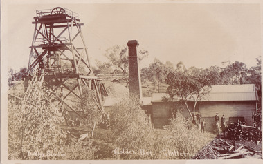
This object is a photographic postcard showing some of the above-ground structures of the Golden Bar mine in Chiltern, including a building with a smokestack and the poppet head which is used to haul equipment, materials, and men above or below ground. The Golden Bar site, mined by the Golden Bar Mining Company which was formed in 1901, managed to yield approximately 12,453 oz of gold before work stopped in 1912 - it was one of the principal mines in the area, as well as the deepest and one of the richest. The text on the postcard was handwritten by H.Gordon (?) to Issy (?), to show the mine where he presumably worked as he promises to take them 'above and below'. The postcard can be approximately dated to between 1901-1912. It is stated that after 1902 Kodak added the line on the postcard backs to divide into correspondence and address sections as seen on the reverse of this object. In addition, there is also a similar Kodak photographic postcard in the Burke Museum collection that is dated to 1908 and has the same specific font type and manufacturer markings (see references for link). Lastly, the Golden Bar mine ceased operations in 1912 so the photograph was likely taken prior to this. This photographic postcard is a rare and fair conditioned representation of one of the most significant gold mines in the Chiltern area, showing the above ground structures at the time it was being actively mined. This postcard also holds social significance as a snapshot of working life in the gold mining rush of Victoria, and a personal record of one of its miners. A sepia rectangular postcard printed on card.Obverse: Dudley Studio / Golden Bar. Chiltern Reverse: BMM 8034 / Post Card. / Correspondence. / Address Only. / Kodak. Austral. 110 / My Dear Issy (?), / A card only, to show (?) the mine / and when you come down I will / take you above and below, / All (...) love, me to. Has the baby / gone home yet Heini (?) wants to know / give my love to Syd when next you write / Your loving (...), H. Gordon (?)photographic postcard, postcard, chiltern, golden bar mine, golden bar mining company, dudley studio, kodak -
Ringwood and District Historical Society
Programme, Ringwood Eisteddfod Programme - 2010, 2010
List of sections in the Ringwood Eisteddford 2010 and the Grand Final Aria and Concert to be held at the Karalyka Theatre,Mines Road, Ringwood East. Written by Ruth HawkinsSingle handwritten page of the Programme of the Eisteddfod 2010 +Additional Keywords: Hawkins, Ruth -
 Bendigo Military Museum
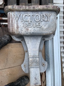
Container - RAIN HEAD, 1919, Post WW1
This Rain Head came from what was originally the “School of Mines” in Bendigo which is now part of “TAFE”.Rain head, cast, top section is rectangular shape with cast lettering on, drainage tapers down, near the bottom is a depiction of a Rising Sun cast in. Measurements are an estimation at this stage.“Victory 1919”rain, head, container -
 Bendigo Military Museum
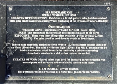
Weapon - SEA MINE, MARK XV11, 1939 - 45
This mine is situated in the gardens of the Bendigo District RSL Sub Branch Inc Havilah Road Bendigo. Refer photo .1) re details of manufacture and its history/use..1) Plaque on black metal stand with white text with details re the mine. 2) Mine slightly oval shape, black with a white band, the top has a bolted on section as a lid, there are multiple "horns" attached around the mine.Refer .1) plaque.brsl, smirsl, bdrslinc, sea mine -
 Bendigo Military Museum
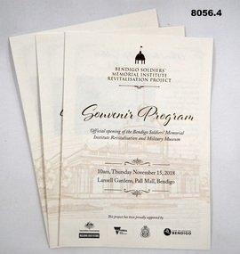
Pamphlet - SOUVENIR PROGRAM, SOLDIERS MEMORIAL INSTITUTE 2018, City of Greater Bendigo, C. Nov 2018
When the SMI was opened in Nov 1921 the Bendigo RSL Sub - Branch had occupancy from that day on. The Building became a Museum opened to the public in 1998 by the RSL. The origins of this project goes back to 2011 with a letter to the City of Greater Bendigo of the possibility of an upgrade to the SMI from the Bendigo District RSL Sub - Branch Inc. Some renovations had already taken place and some structural work. After initial talks a sub - committee of 3 persons from the RSL was elected to work with the Council along with other bodies who would be involved. Plans eventuated by 2015 and were put to the RSL for approval. From there the fund raising began from the State/Federal Govt's, RSL, the Public and Council itself. This was achieved and finally in Sept 2016 the SMI/Museum was packed up completely and the Renovations began in 2017. Souvenir program, card yellow colour folding, front page is in gold and black writing with an image of the Dome on the SMI followed by in gold, "Bendigo Soldiers Memorial Institute Revitalisation Project" then in gold, "Souvenir Program", in the centre has details re time, date, place. At the bottom are the logo's of the Federal & State Governments, RSL and City of Greater Bendigo Page 2 is titled "About the Bendigo Soldiers Memorial Institute" with a photo showing the "Hustlers Royal Reserve Mine No 2" which was on the site where the SMI now stands. Page 3 has details of the program, music, Official welcome, speakers, ribbon cutting, the ODE, Last Post, National Anthem, close of formalities and light refreshments. Page 4 has a photo of the original souvenir pamphlet used at the original opening on November 15th 1921, 97 years to the day. at the bottom, "Thankyou section to all those involved in the project""Official opening of the Bendigo Soldiers Memorial Institute Revitalisation and Military Museum 10am Thursday November 15, 2018, Lansell gardens, Pall, Mall Bendigo"brsl, smirsl, program -
 Eltham District Historical Society Inc
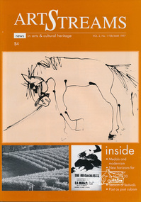
Journal, Peter Doughtery, ArtStreams: News in arts and cultural heritage; Vol. 2, No. 1, Feb-Mar 1997, 1997
Vol. 2, No. 1, Feb-Mar 1997 CONTENTS MEDALS AND MODERNISM A retrospective look at the cultural impact of the Melbourne Olympics 3 CD REVIEWS 6 NEW HORIZONS Judy Jacques takes a new direction 6 LA MAMA 30 YEARS ON Liz Jones at the helm 10 PAST AS POST CUBISM Annita Furey on Heather Shim men 14 GRAPE GRAZING FESTIVAL Food, wine and music in the Yarra Valley 16 SHORT STORY Fantasia on a cup of coffee 18 WHAT'S ON A round-up of events for February 22 WHO'S TEACHING WHAT Classes in the region 24 FRANCES DUFFY RETROSPECTIVE An artist who extended the boundaries of tonalism 26 ANDY WARHOL AND THE CAN OF SOUP More than 15 minutes of fame 27 A ‘DUTCH’ FESTIVAL COMES TO ST ANDREWS 28 LISTINGS Artists, performers and galleries 29 "Peter Dougherty has been involved in the local art scene for many years. As publisher and editor of the arts magazine Artstreams, his comments on the various branches of the arts are widely respected. His "The Arts" column in the Diamond Valley Leader presents a brief summary for a much wider cross section of the local community. Peter also operates his own gallery and the Artstreams Cafe at the St Andrews market. Peter has a wealth of knowledge about present day and historical aspects of local art and artists." - Eltham District Historical Society Newsletter No. 161, March 2005Colour front and back cover with feature articles and literary pieces with photographs and advertisements printed in black and white. 36 pages, 30 cm. Vol. 1, no. 1 (Nov. 1996) - Vol. 10, no. 5 (summer ed. 2005/06) 1956 melbourne olympics, 1956 olympics, 1995 eltham arts ball, a.d. (archie) colquoun, abu baku, adams of north riding, afandi siyo, albert namatjira, alice (1956), andy warhol, annita furey, anthony dymke, art streams magazine, ballarat school of mines, bathing in the dark, bob sedergren, bob valentine, bourbo's belly, brian brown quntet, bulleen art & garden centre, cafe margot, charles blackman, christine edwards, circushead, clifton pugh, cottlesbridge, council amalgamation, cuddlefish, dave pithouse, david lord, david tolley, dawn sime, dione mcintyre, dixon's creek, edward grigoryan, eltham college concert band, eltham wiregrass gallery, erika mcgilchrist, fergusson winery, food for all seasons, frances duffy, fred williams, frenzi, geoff achison, geoff mainwaring, graeme bell, grape grazing festival, half caste child, heather shimmen, hoodangers, isobel lindsay, james wakeling, janette geri, john brack, john mcall, john murphy, jordie albiston, judy jacques, kath mckinnon, katherine's silly women, kelly 1956, ken harrison, kevin borland, kim harriss quartet, la mama theatre, lauurie dawes, leonard french, lighthouse, liz jones, lloyd jones, lothlorien, lovegroves, lovey's estate, luxum, maelstrom, max meldrum, may grigg, michelle nicolle, mighty servant, mirka mora, miss suzannah espie, moma, montsalvat jazz festival, moonee valley drifters, moonlight shadow, museum of modern art at heide, mystery train, the melbourne jazz band, nicole eveleigh, nigel shipley, olympomania, peter mcintyre, phyllis murphy, pip avent, portrait of georges mora (1956), ray horsfield, red shed theatre company, reed's gallery, richardson house (1955), river house (1955), robin boyd, sandro donatti, secret of the west wind, seville, shantell vineyard, shedlevellers bush band, shirley bourne, sigmund jorgensen, sir william dargie, soul sister swing, sydney nolan, that handsome couple, the band who knew too much, the broken fence (1956), the gusset rustlers, the rhonda movement, the russian gypsey jazz quartet, three amigos, victorian artists supplies, warburton, wholefood delights, yarra valley grape grazing festival, yellow dog jazz band, yering station, art streams -
Federation University Historical Collection
Booklet, Ballarat School of MInes Certificate Book, 1911-1912, 1911-1912
A Certificate stubb book, the stub recording when a Ballarat School of MInes certificate was collected, and the right hand section signed by the person who picked it up. g.o. ramsay, assaying, mining engineering, reginald a. roberts, virgil tucker, thomas sim, fitter and machinist, john worthington, ernest h. fraser, metallurgy, george w. cornell, thomas r. williams, mt morgan, jubilee hill, e. morshead, engineering drawing, norman buley, p.e. marmion, loyal h. finch, engineering draughtsman, elsie lewis, dressmaking, dresscutting, harold h. bieske, chemistry, mineralogy, leslie james middleton, f.v. retallack, a.g. campbell, mining engineering, leslie j. coulter, w. baragwanth, geology, w. moon, w.j. sayer, john f. foster, j.h. thomas, algebra, geometry, electrical technology, francis c. hall, chemistry, dynamics and heat, applied mechanics, vincent m. booth, turning and fitting, fitting and turning, steam and gas engines, h.i.w. dixon, colin c. corrie, f.v. retallack, r.a.j. roberts, v.e. mellington, j. sides, trigonometry, h.j. whittingham, w.h hull, milton williamson, a.c. stanger-leathes, w.j. mckenzie, e.s. anderson, richard g. walker, h.g. cornell, r.h. achison, s.h. mayo, allan o'meara, r.m. serjeant (jnr), j.h. thomas, l.h. finch, leslie j. middleton, virgil tucker, h.e. hawkesworth, r. ingram moore, reginald e. callister, rudolph bieske, j.f. roy, william geldard, w. richardson, l. trahar, albert j, robin, tongala, mine surveying, land surveying, john l. sampson, edgar c. hurdsfield, george e. stephenson, sherbourne hal. sheppard, oliver w. williams, e. mowbray boyer, first aid to the injured, lilliam nankervis, alan j. perry, albert e. coates, r. hamlyn, r. ironbridge, s.e. ellsworth, j.m. matthews, ross ironbridge, sarag e. ellsworth, frncis r. mcgregor, f.g. middleton, dora furness, v. matthews, george farmer, d. owen, ethel m. woolcock, r.j. walker, port pirrir, n. buley, electricity and magnetism, l.s. anderson, aubret simmons, william f. williamson, robert n. allan, jack blackie, nelson h. ferguson, ronald ferguson, w. mckenzie, david w. bonar, harry j. myles, charters towers, howard hall, r.a. roberts, william baragwanath, guy o. ramsay, harold bieske, leslie coulter, john foster, francis hall, vincent booth, colin corrie, milton wiliamson, albert coates, francis r. mcgregor, ethel woolcock, aubrey simmons, ronald j. ferguson -
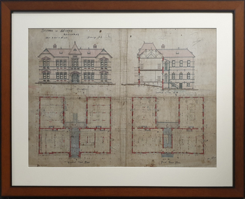
 Federation University Historical Collection
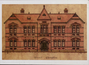
Plan - Postcard, Front Elevation of the Ballarat School of Mines New Classrooms (now Administration Building), 1898, 16/02/1899
In 1900 this building was described as 'handsome in design, well lit, well ventilated, commodious - containing Council room, office, chemical laboratory, mineralogical laboratory, students room and six lecture rooms. Postcard of the original hand coloured plan on linen of the Ballarat School of Mines New Classrooms (from 2014 known as the Federation University Australia SMB campus Administration Building). The plan shows the front elevation, section on line, ground and 1st floor plan. ballarat school of mines, new classrooms, administration building, architectural plans -
 Bendigo Military Museum
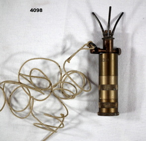
Weapon - MINE DETONATOR, 1939 - 45
German “Bouncing Betty” mine detonator fuse, S.Mi. Z 35.Brass cylinder with three knurled sections on main part, above a cross piece with knurl one end and ring with cord at other end, above that is 3 prongs.german, bouncing betty, detonator -
 Federation University Historical Collection
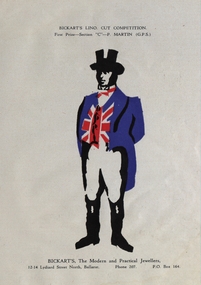
Artwork - Print, P. Martin, Bickart's Lino Cut Competition First Prize Winner Artwork, 1940
Ballarat School of Mines and Industries is a predecessor of Federation University.Blue, Black, white and red artwork for the Bickart's Lino Cut Competition at School of Mines Ballarat published in the School of Mines Ballarat Students Magazine 1940. First Prize - Section "C" - P.Martin. Bickart's, The Modern and Practical Jewellers.ballarat school of mines, ballarat school of mines and industries, p. martin, bickart's, lino cut, competition, bickart's lino cut competition -
 Federation University Historical Collection
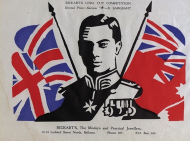
Artwork - Print, B. Sargeant, Bickart's Lino Cut Competition Second Prize Winner Artwork, 1940
Ballarat School of Mines and Industries is a predecessor of Federation University.Blue, Black, white and red artwork for the Bickart's Lino Cut Competition at School of Mines Ballarat published in the School of Mines Ballarat Students Magazine 1940. Second Prize - Section "A" - B. Sargeant. Bickart's, The Modern and Practical Jewellers.ballarat school of mines, ballarat school of mines and industries, bickart's, lino cut, competition, bickart's lino cut competition, b. sargeant -
 Federation University Historical Collection
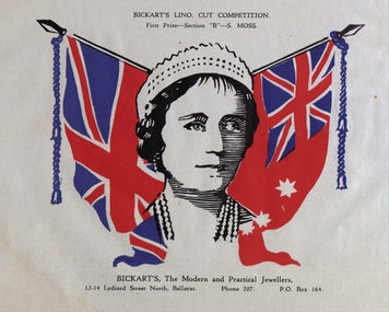
Artwork - Print, B. Sargeant, Bickart's Lino Cut Competition First Prize Winner Artwork, 1940
Ballarat School of Mines and Industries is a predecessor of Federation University.Blue, Black, white and red artwork for the Bickart's Lino Cut Competition at School of Mines Ballarat published in the School of Mines Ballarat Students Magazine 1940. First Prize - Section "B" - S.Moss. Bickart's, The Modern and Practical Jewellers.ballarat school of mines, ballarat school of mines and industries, bickart's, lino cut, competition, bickart's lino cut competition, s. moss -
 Federation University Historical Collection
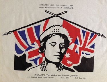
Artwork - Print, B. Sargeant, Bickart's Lino Cut Competition Second Prize Winner Artwork, 1940
Ballarat School of Mines and Industries is a predecessor of Federation University.Blue, Black, white and red artwork for the Bickart's Lino Cut Competition at School of Mines Ballarat published in the School of Mines Ballarat Students Magazine 1940. Second Prize - Section "B" - B. Sargeant. Bickart's, The Modern and Practical Jewellers.ballarat school of mines, ballarat school of mines and industries, bickart's, lino cut, competition, bickart's lino cut competition, b. sargeant -
 Federation University Historical Collection
Map - Geological, Tallangatta, New South Wales: 1:250,000 Geological Series, SJ 55-3, 1966, 1966
Compiled by the Geological Survey of N.S.W., Division of Regional Geology. Topographical base compiled from Snowy Mountains Hydro Electrical Authority, Department of Lands, County maps and Snowy Lease Map. Other sheet adjoin this map. There are 13 formation sections grouped into 9 - Quaternary, Tertiary, Middle Devonian, Lower to Middle Devonian, Lower Devonian, Upper Silurian, Silurian, Upper Ordovician and Ordovician.Large coloured map showing geological features, faults, bores, rivers and mineral deposits.Scale of map, longitude and latitude, river names. "Tallangatta 1:250,00" written in black pen.tallangatta, new south wales, geological survey, topographical base, snowy mountains hydro electrical authority, department of lands, snowy lease map, department of mines, quaternary, tertiary, middle devonian, lower to middle devonian, lower devonian, uper siluran, silurian, upper ordovician, ordovician -
 Federation University Historical Collection
Book - Diary, John Kennedy, John Kennedy's Ballarat School of Mines Lecture Notes, 1889
John Kennedy was born on 04 April 1862, the son of ship carpenter Robert Kennedy and his wife Florinda (Aitken), and the brother of Malcolm and Colin Kennedy. In 1860 the family migrated to Melbourne where Kennedy senior set up as a shipwright. In 1879 Malcolm and John, who trained as a naval architect, joined their father as Robert Kennedy & Sons, shipbuilders and shipsmiths. On 27 December 1883 at North Melbourne, Malcolm married Ann White with Presbyterian forms. Next year Robert Kennedy & Sons removed to Hobart where with John W. Syme and W. J. Duffy, partners until 1889, they took over the Derwent Ironworks & Engineering Co., a foundry formerly owned by the (Alexander) Clark family. The Kennedys also acquired the patent slipyard, formerly Ross's, at Battery Point. After the shipbuilding industry in Hobart began to flag John also turned to mining: he attended the Ballarat School of Mines, and reopened the Hobart smelters which had been an adjunct of the Derwent Ironworks in the 1870s. He made several voyages overseas on smelting business and as mining promoter, and was a member of the London Stock Exchange. In 1913-14 he was manager of Tongkah Compound (1910); Robert Kennedy & Sons was reputed to have contributed to the success of the Hobart-run Tongkah Harbour, Thailand, tin mines by developing a suitable dredge. The brothers also held shares in the Irrawaddy Burma Co. John was a member of the Australasian Institute of Mining Engineers and from 1932 an honorary life member of the American Institute of Mining & Metallurgical Engineers. John died in Hobart on 10 January 1937. (Ann G. Smith, 'Kennedy, John (1862–1937)', Australian Dictionary of Biography, National Centre of Biography, Australian National University, http://adb.anu.edu.au/biography/kennedy-john-7092/text11963, published first in hardcopy 1983, accessed online 24 April 2020.) A book covered in black leather with 'John Kennedy' embossed on the front in gold. The book contains notes from the time he studies at the Ballarat School of Mines. The beginning of the book has an alphabetical section where John Kennedy has created an index.Inside front cover 'John Kennedy Nena Wharf Hobart Tasmania.' john kennedy, australasian institute of mining engineers, ausimm, american institute of mining metallurgical engineers, ballarat school of mines, lecture notes, lecture notebook, antinomy, brick clay, carbon, coal, copper, chemistry, clay, chrome, electricity, fire clay, gas, gold, gold bullion, glass, gold test for, iron metallurgy, light, lead, metallurgy, mica, mineralogy, pyrites, sulphur in pyrites, sugar, slags, wolfram, preparation of pure gold, scorification, gold bullion assay, petrography, melting poinys of bodies, metric system, geology, mount morgan, queensland, rock salt, assay of tailings, classification of rocks, muffle furnace, ballarat school of mines wind furnace, assay of antinomy, recovery of silver from solutionsheat pyrometer, spectroscope, organic acids, metallurgy of iron, assat of copper, cornstock lode nevada, mount morgan queensland, scarification, elmwood, metallurgy of lead, specific gravity, copper assay, seperation of gold from other metals, test for gold, wet assay, mercury -
 Federation University Historical Collection
Plan, Architectural Plan for the Ballarat School of Mines New Classrooms, 1899
Framed original plan of the Ballarat School of Mines New Classrooms (later called the Administration Building). The plan includes a front elevation, a gound floor plan, first floor ground plan, and a section on line. ballarat school of mines, architectural plan, administration building, new classrooms -
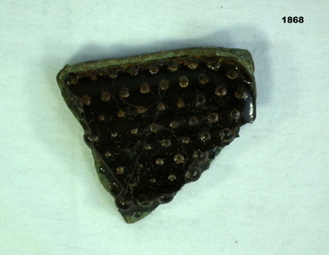 Bendigo Military Museum
Weapon - CLAYMORE MINE FRAGMENT, C.1971
The Claymore mine is a directional mine with 700 small ball bearings. This small section was brought home from Vietnam by George Cameron Wood No 3798253. Refer Cat no 1872 for his service history.Corner section fragment from an M18A1 Claymore anti-personnel mine. Hard green plastic front, rear has a large number of approx. 3mm diameter ball bearings set in black epoxy resin.arms-ammunition, claymore -
 Federation University Historical Collection
Article - Article - Women, Ballarat School of Mines: Women of Note; Emily Stitfold, Photographer, (1866-1948)
Emily Ann Hanson Stitfold was born in Ballarat in 1866 to Thomas Stitfold and Sarah Stitfold (Hanson). There were six children, one boy and five girls. Emily attended photography classes at Ballarat School of Mines in 1896 (Grade !) and 1898. Photography was a new course offered and she was one of the first students to attend. She became a member of the Ballarat Amateur Photographic Association. Emily died in 1948 and is buried in the Ballarat Old Cemetery. (BN Section 19 Grave 9). Her parents, Thomas and Sarah are also buried in the Old Cemeterywomen of note, ballarat school of mines, emily stitfold, photography, student, ballarat amateur photographic association, ballarat old cemetery, thomas stitfold, sarah stitfold -
Federation University Historical Collection
Book - Book - Scrapbook, Ballarat School of MInes: Scrapbook of Newspaper Cuttings, June 1968 - December 1968
Collection of newspaper articles related to Ballarat School Of Mines.They cover activities and advertisements for staff. The papers concerned are The Courier, Ballarat, The Australian, The Age over the period from 01/06/1968 to 02/12/1968.Book with deep red and white cover back and front, spiral bound. staffing advertisements, master builders' scholarship, jeff white, robert kerr, smb progress at mt clear, peter dudley, rio tinto scholarship, smb computer centre, art in the sunshine, stock exchange award to min j loo, commonwealth inquiry re salaries, analogue computer, apex projects, business studies group from mildura, ben burrow to united states, defence standards laboratory melbourne, gas company scholarships, john grant, ian day, visitors from maryborough, secondary teachers art and craft course, new exam report, vandals at smb building site, look first decide later on careers, visitors' day at smb, diplomas for 51 students, smb staff visit 20 schools, high priority for smb residences at mt helen, brewing course, autonomy for colleges, completion of woolclassing building, mr g mainwarring to paint picture for australian war museum canberra, demolition of old gaol wall, smb titles for main sections, $130, 000 computer for smb, error over water supply connection at mt helen, basketball premiers, ugandan minister on visit to school, teachers' college wins annual sports, smb won annual trades fours, ballarat rowing association, visit to ambulance station, david pell top student in accountancy, bendigo visit by smb, michael young sculptor prize winner, united states and australia communications re tertiary education, josephine brelaz trust fund -
Federation University Historical Collection
Book - Book - Scrapbook, Ballarat School of MInes: Scrapbook of Newspaper Cuttings, Book 16, October 1982 to February 1983
Collection of newspaper articles related to Ballarat School Of Mines.They cover activities and advertisements for staff. The papers concerned are The Courier, Ballarat, The Australian, The Age over the period of 27 October 1982 to 12 February 1983.Book with white cover, front, spiral bound. courses available, teaching positions advertised, higher education faces crises, master builders drop scheme for apprentices, will a local win "skill olympic", ivan clarke, robert eva, art and craft salvation, edith lawn, horticulture course in ballarat, proposed tafe changes will create difficulties, apprenticeship scheme fails, courage on ice, dick richards, lord shackleton, anthony morris organist wins award, guild of music and speech, tonia ruyg second in ladies hairdressing section, work skill australia, cooking apprentice ian irving won regional award, skill work winners, ten more apprentices for ballarat, apprentices win award, daryl scheggie-brendan breust-phillip tjerkstra, matthew heenan photographic contest, awards night, mechanical engineering graduates, hugh lees - bruce hodgson - theo goossen, brett hodge apprentice electrical mechanic, sculptor victor edward greenhaigh, shackleton's forgotten argonauts, farmer apprenticeships win praise, back - to - school liftout, what's on in '83 at smb, tafe courses and programs in the central highlands, boom predicted for ballarat nurserymen, john harris coordinator horticulture course at smb -
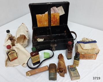 Flagstaff Hill Maritime Museum and Village
Equipment - First Aid Case, Thomas Urquhart & Son Pty Ltd (Thos. Urquhart), 1930-1939
This small, portable 1930s Sanax First Aid Case has been strongly constructed, with corners reinforced with metal to take knocks and bumps, so it could be quickly transported to the site of an emergency. Having these supplies organised into a kit made them easily accessible and reduces time to take them to the site of the accident. It was possibly designed for use in factories because the booklet in the case states that the kit complies with “Part 1, Victorian Factories Regulations”. The text of the printed brand “Sanax First Aid Case” is right-way up when the case stands vertically on its hinged side. In modern times people are well aware of the importance of quick treatment when accident and injury occur. However, before the first commercial First Aid Kit was made by Johnson & Johnson in 1888, people had little knowledge about treating injuries and lacked information about suitable supplies to keep on hand for emergencies. They were often unaware of how to help in that critical time before the doctor or other assistance arrived, a particularly important time for the many people living in remote areas. A quote from Johnson’s & Johnson’s 1888 price list explains “It is a fact, which is everywhere being recognized, that many lives are lost and much suffering entailed in such accidents on account of the lack of the simple but necessary articles required to afford prompt assistance to the wounded.” One example of the value of First Aid assistance to community groups is shown in an article from the Weekly Times, 29th November 1930. It records a report from the Annuello Branch of the Younger Set (a Country Women’s Organisation), telling that on Armistice Day their president Mrs Jamieson, presented the Annuello School with the gift of a Sanax Red Cross First Aid outfit, which was accepted as being “of great practical use to the scholars.” (Annuello is a remote wheat growing area in the Mallee region of North Western Victoria, which became a soldier settlement area after World War I. There is a strain of wheat named ‘Annuello’ due to its suitability for that area. ) The Sanax Case in our Collection contains instructions, equipment and medical items suitable for use in emergency situations. The Case was one of 42 patterns available from Sanax that conformed to ‘Part 1, Victorian Factories Regulations’. It includes items made by Sanax Company and by Burroughs Wellcome & Co. (Australia) Ltd., Sydney, NSW. A quote at the back of the First Aid Emergency Instructions booklet says: “Sanax products are made in Australia by or under the supervision of qualified chemists, from the highest quality materials. They are dependable for the purposes written on labels.” BOOKLET included in First Aid Case: “SANAX” First-Aid Emergency Instructions has orange cover and white pages, joined in the centre by two staples. Booklet contains First Aid Instructions for general events listed in alphabetical order. It also contains an indexed sections headed “Poisoning, and what to do” written by S.A. Burrows, Ph.C., Vuc and N.Z. There are instructions and diagrams on how to perform Artificial Respiration. There are advertisement for Sanax products throughout the booklet that include; - Sanax Ambulance Stretcher for timber mills, mines, ships and quarries - Saw dust masks (porous rubber) for workers in dust, paint or duco sprayers Inside cover lists Sanax’s Australian made products including - tablets and powders for headaches, neuralgia, influenza, colds - snuff for Catarrh that is “quite harmless” - First Aid Cases that come in a range of 42 patterns - sunburn preventatives and treatments - healing salve for carbuncles, pock, pimples, boils, varicose ulcers etc. - snake bite outfits and kits LEAFLETS included in First Aid Case: (1) Tannafax Tannic Acid Jelly. Tannafax should be kept at hand in every home. It should be applied direct from the tube and used with neither oil nor grease. Where a large area has to be covered the clamped end may be torn or cut off to give a wider mouth to the tube. Collapsible tubes of different sizes. Made in Australia. Burroughs Wellcome & Co. (Australia) Ltd. (Incorporated in England). Sydney, NSW. Assorted Houses, London, New York, Montreal, Cape Town, Milan, Bombay, Shanghai, Buenos Aires. Copyright A. 1817, J. 9463 (2) Tabloid. The strong thing is the just - - . Tabloid marks the wor - - Burroughs Wellcome & Comp. The use of the word is to enab – the prescriber, dispenser and patient to get the right thing with one short word, instead of the firm’s long name. If another maker apply the word to his product, the act is unlawful. Tabloid is our trade mark and brand. If a vendor disregard it in dispensing or selling, the act is unlawful for the same reason. We prosecute both offenders rigorously, in the interest of prescribers, dispensers, patients and the owners of the trade mark. Please inform us of any instance of either offence. Burroughs Wellcome & Co. (Australia) Ltd. (Incorporated in England). Telephone Number - M 4184 (4 lines) All communications to G.P.O. Box No. 1185 DD. Copyright Sy. 20. & J 9894. Medicines and Equipment included in First Aid Case: - Absorbent Cotton, Sanax, for absorbing blood or drying a wound. As a swab for washing wounds; to place above a compress to keep the heat in: or as a pad to protect wounds or fractures. The Sanax Co. Manuf. Chemists, Melbourne. Regd. Office: 5 Brunswick St, Fitzroy. N.6. - ACHE tablets, Sanax, for all aches, pains, fevers etc. Dose: 2 to 3 tablets with a draught of water, every 3 hours. Children in proportion. For influenza or colds, take the bedtime dose with a hot lemon drink or toddy. Recommended for Headaches, Colds, Influenza, Fevers, Neuralgia, Rheumatism, Nerve Pains, Sleeplessness, and Seasickness. Three Sanax Ache tablets equals one Sanax Ache powder. Each tablet contains 1.75grs. each Phenacotinum and Acety acSzilcyl, and .75grs Ammon Brom. Etc.. Sanax brand specialties are prepared by highly qualified pharmaceutical chemists and may be accepted as safe and effective for the purpose indicated on the label. The Sanax Co. Melbourne - Eye lotion, Sanax, “in eye bath full strength or diluted with equal parts of water. Sanax Co. Brunswich St, Fitzroy, Melbourne. - Iodine, Sanax, POISON, with instructions for what to do if swallowed. - Kuraburn, Sanax, Applied to the burn and allowed to dry, the pain and heat instantly disappear, and blistering is prevented. If necessary, apply again in an hours. To safeguard against burning when sunbathing, apply before exposure to the sun. If already sunburnet, use Kuraburn as directions above. Safe and harmless. Sole makers, The Sanax Co. Brunswick St. - - Vic. - Sal Volatile, Sanax, - - stimulant for - - nervous aches - - or as smelling salts Dose - - - - Solution of A- - - 5%, . The Sanax Co. Brunswick St, Melbourne. - Tannafax, Burroughs Wellcome & Co. Australia Ltd. Sydney, N.S.W., 20gm. Approx., Tannic Acid Jelly, (Tannic Acid with 0.5% Phenol in a water-soluble base) for burns and scalds. A.N. 15050, p188, logo of a unicorn. Apply lightly, allow to dry, and bandage loosely. Do not apply oil or grease. - bottle wrapped in brown paper, unknown contents, paper adhered to bottle. - dish, kidney shaped, metal, white enamel with black rim - eye bath, green, plastic or Bakelite SANAX COMPANY The Sanax Company was at the address of 5 Brunswick Street, Fitzroy [Melbourne] at least as early as November 1924, as shown by its advertisement of Ache Powder in the Weekly Times, 8th November 1924. It was still at this address in September 1951, when it advertised First Aid outfits and components in the Post Master General’s section of the Commonwealth of Australia Gazette. REFERENCES: Annuello, Victoria; Wikipedia, https://en.wikipedia.org/wiki/Annuello,_Victoria Annuello Younger Set, Branch Activities and Local Reports, Country Women’s Organisations, Weekly Times, 29 November 1930, Trove http://trove.nla.gov.au/newspaper/article/224921009?searchTerm=%22sanax%22%20and%20%22melbourne%22&searchLimits=# Commonwealth of Australia Gazette, Issue 32, 24th April 1915, https://www.legislation.gov.au/file/1915GN32 [Johnson & Johnson Price List, September 1, 1888, p. 20. From our archives], Celebrating the 125th Birthday of the First Aid Kit , The Story of Johnson & Johnson, , http://www.kilmerhouse.com/2013/06/from-1888-to-2013-celebrating-the-125th-birthday-of-the-first-aid-kit/ Post Master General’s section of the Commonwealth of Australia Gazette, Issue No. 73, Thursday 27th September 1951 http://trove.nla.gov.au/newspaper/article/232185299?searchTerm=%22sanax%22%20and%20%22fitzroy%22&searchLimits= Sanax First Aid Emergency Instructions, by S.A. Burrows, publisher Sanax Ltd. Fitzroy, Victoria, 1930-1939 English, book, Illustrated edition, Trove http://trove.nla.gov.au/version/40948895 Access to emergency medical help in early settlement days of Victoria could take quite some time, especially in remote areas. From 1888 First Aid Kits and instructions became available for work sites, offices, community groups and individuals, helping to bridge the gap between the accident and the arrival of medical assistance. This portable Sanax First Aid Case is an example of portable medical equipment made in Melbourne, Australia, in the 1930’s and available to the public. It contains a range of items plus information to be used in a variety of injuries and emergencies in in factories, households, businesses and local communities, and instructions on their use. First Aid Case, portable, Sanax First Aid Case. First Aid kit in strong black cardboard carry case with metal reinforced corners, metal hinges on lid, metal catch and leather carry handle. Inside lid is a vertical strap with narrow gap behind it. Base is divided into two compartments. Manufactured by Sanax, Fitzroy, Melbourne, C. 1930-1939 Contents include "Sanax" First Aid instructions booklet, 2 leaflets, metal kidney dish enamelled in white with black trim on edge, green plastic or Bakelite eye bath, eye lotion, Tannafax tannic acid jelly, Sal Volitile, Kuraburn, Iodine, Argyrol, ACHE tablets, absorbent cotton in cardboard box, gauze bandage, and UNKNOWN wrapped bottle. Printed in gold on lid of case “SANAX” FIRST AID CASE. Most of the contents, as well as the case, show the “SANAX” brand. Some contents are inscribed Burroughs Wellcome & Co. (Australia) Ltd., flagstaff hill, warrnambool, shipwrecked coast, flagstaff hill maritime museum, maritime museum, shipwreck coast, flagstaff hill maritime village, great ocean road, first aid items, first aid kit, emergency first aid, medical emergency kit, home emergency kit, industrial emergency kit, sanax company fitzroy melbourne, burroughs wellcome & co. (australia) ltd, thos. urquhart & son pty. ltd. melbourne, sanax first aid case, sanax first-aid emergency instructions, part 1 victorian factories regulations, tabloid medical supplies -
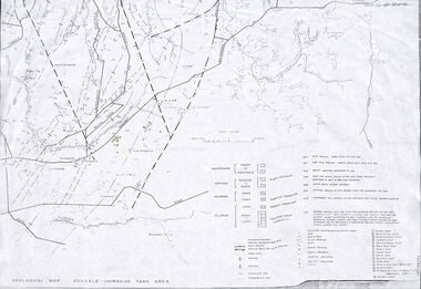 Ringwood and District Historical Society
Map - Maps, Geological Map Donvale to Chirnside Park, also Victorian Railways Maps of Hawthorn to Lilydale Line incl Ringwood to East Ringwood - 1881
Faint photocopies of sections of larger maps. Geological map includes location of mine shafts circa 1920.Victory Shaft, North Victory Shaft, South Caledonia Shaft, Caledonia Shaft, North Caledonia Shaft, Black Swan Shaft, Reward Shaft, Consols Shaft, Blocks Shaft, Devonshire Shaft, Crown Shaft, Yarra Tunnel Reef Working, Bright's Shaft, Kingwood Antimony Company Shaft (Boardman's Shaft), Southern Shaft. -
 Federation University Historical Collection
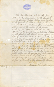
Letter - Correspondence, James Oddie, Statement from James Oddie, 09/06/1886
James Oddie was Vice-President of the Ballarat School of Mines in 1886.Blue, lined, foolscap paper from Ballarat School of Mines Logo. It is handwritten by James Oddie for the Ballarat School of Mine Council and is in regards to the duties of Professor Ferdinand Krause."The Vice-President submits the following statement for consideration by the Council: - On Tuesday 1st June between 2 and 3 o'clock in the afternoon I called on Professor Krause and requested him to prepare plans and sections with a view to the erection of furnaces, machinery, and appliances which the committee appointed by Council had resolved upon obtained for the School. Mr Krause at once refused, urging that this work was outside his duties, but that he would be willing to undertake it if allowed a remuneration of 5% which was 2 1/2 % less than a professional engineer would charge. He took exception to a paragraph that appeared in the "Ballarat Star" of the 28th May which referred to the visit and inspection of the Honorary Staff or mechanical engineers on the day previous. He further stated that he was not going to be a shoeblack to these persons and his language and manner was generally offensive and insubordinate. The progress of the work is thus considerably delayed. James Oddie"ballarat school of mines, oddie, krause, mining, furnace, james oddie, ferdinand krause -
 Federation University Historical Collection
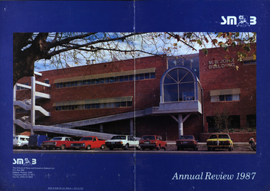
Booklet - Annual Review, Ballarat School of Mines Annual Review, 1986 -1991
The Ballarat School of Mines was established in 1870 through the initiatives of the Ballarat Mining Board making it the oldest site of technical education in Australia. The Board was concerned with the shortage of mine managers for the goldfields. Classes began in surveying, mathematics, and chemistry and a decade later they included metallurgy , assaying and geology. With the decline in goldmining the direction of the college changed and broadened, the art School was established and the Ballarat Junior Technical School developed. In 1976, the tertiary sector seperated from the School of Mines and Industries Ballarat to form the Ballarat College of Advanced Education. In the 1980s SMB was a Community College of Technical Education and Further Education (TAFE) offering a wide range of vocational, enrichment and preparatory programs. It is continuing the tradition of providing for the educaiton needs of people within the Central Highlands. During the 1970s and 80s it acquired and refurbished old buildings and developed new facilities to keep up with the needs of an expanding curriculum and student population. The era of these annual reports is just before the merger with the University of Ballarat.A number of soft card covered annual report for the Ballarat School of Mines. .1) 12 page black covered report featuring an image of the E.J. Tippett Library. Includes information on death of E.J. Tippett, disability policy, Peter Quinn, Patti McNulty, Bob Feary, Shane Everand, Integration, Fiona Watson, retirement of Robert Morgan, Opening of the carpentry and Joinery Facility in Davey Street, formation of the School of Business and Information Technology, Melissa Bone, opening of the E.J. T. Tippett Learning Resource Centre (Library), Refurbishment of the Administration Building, Food Service Building (Prospects), Court House Theatre, Enrolment centre, Museum, Creche, Women's Trade technical Program, Rural Education Program, Ararat Prison Program, Community Studies Section, Ararat Adult Literacy Group. Literacy Assistance for Undergraduates, Fire training, fitness, open Learning, Training & Employment Group, Awards, Filipino Visitors, oil Seed Research, Brunei, Barometer (gift) for Horticulture, Special Equipment (guillotine and brake press; programmable logic Controller; theodolite: laser lever; Universal testing Machine; Atomic Absorption Spectrophotometer)., organisational Structure. Photos include Ken Flecknoe, Peter Quinn, Patti McNulty, Bob Feary, Shane Everard, Fiona Watson,Linda Bland, Robert Morgan, David McCaughey, E.J. Tippett, Frank Sheehan, Julie Baulch, Jo Reeves, Col McCurry, Jenny Garnham .3) Blue covered book with a photograph of the M.B. John Building taken from Albert Street on the cover. Topics include: Ken Flecknoe, Peter Shiells, Ararat Campus, David Haddow, Kevin Martin, Rendle Hannah, Gary Eason, Geoff Pope, Albert Peart, M.B. John building opened, Hairdressing Salon, Community Centre, Creche, closure of Lydiard Street, Museum, Jenny Levison, Inskill, Small Business Training, Ballarat Eat free Library, Barkly Street, Wormalds Valve Group, Aboriginal Programs, Horticulture Center, Awards, Country fire Authority, tractor Donation, Women's Policy. Special purchases included surveying equipment with data recorder, test rig , CDT MIG welder, compact gas chromatograph with FID and single pen recorder, Olivetti stand-alone word processing unit. Images include Ken Flecknoe. Peter Shiells, John Crowe, Trevor Slater, Brian McLennan, Kerrie Cross, Albert Peart, John Cain, M.B. John, Enrollment Centre, Museum, Jo Watson, Wormalds, Brian Webber, Dianna Nikelson, Ian Aitken, Brendan B, Chez Dichiera, Heather Dixon, Julie Broadbent .4) 1993 - Brown and white soft covered annual review featuring students of the Ballarat School of Mines at work. Bill Gribble, Brian McLennan, Peter Shiells Retirement, Robert C. Lovett, Steven Mendelson, Max Palmer, Jenny Gough, Mary Molloy, Barrie Firth, Colin McCurry, Dora Hormann, Organisation Structure, Brewery Acquisition, Humffray Street Primary School, Grant Street Retaining Wall, Neville Bunning Plaque, VCE Plus, Ballarat Small Business centre, Ararat Prison, Ballarat Showgrounds Rotunda, .6) Green covered annual review with an aerial photograph over Albert Street, Ballarat. Content include Kerrie Cross, Peter Shiells. Kenneth Flecknoe Obituary, Ian Pimblett, Keith Boast, David Nicholson, Max Palmer, Brian Webber, Bob Lovett, Linda Bland, Prospects, Training restaurant, 3BBB, Malcolm Vallance, Aboriginal Programs, Ian Cathie, Koorie Support Unit, Caroline Hogg, 'Trained Men Make Their Own Terms' exhibition at the Gold Museum, Ricky Hains, Stephen Hughes, Jeff White, Dennis Bolster .8) Blue covered review for 1989. The contents include: Kerrie Cross, Peter Shiells, Ann McCaffrey, Kevin Alsop, Mary Molloy, Ross Furness, Robert Lovett, Victoria Street Student Hostel, Hugh Beggs, Ballarat Small Business Centre, Inskill, Ararat Campus, Hospitality and Tourism, Koorie Support Unit, Fiona Warsn, Bruce Staley, Terry Moran, Anthony Wonish, Ivan Deveson, Leo Shannon Memorial Award, Bryan Crebbin, Geoff Howard, R.C.W. Burdett, Jeff White, Ian Harris, Tom Wiseman, Bill Gribble, Allison Kay, Steven Mendelson, Keith Boast. .9) Grey covered book with a coloured photo of the Victoria Street Student Residence. Contents include: Kerry Cross, Peter Shiells, Morgan Bevan John Illuminated address. Jean Phillips, Koorie Support Unit, Andrew Sullivan, Victoria Street Student Residence, Horticulture, Inskill, Tertiary Awareness Project, Adult Education, Ivan Deveson, Brian Howe, Barry Jones, Joan Kirner, Andrew Trigg, Warren Perry, Murrell Rock Collections, Gwyn Hanssen-Piggott, Disability Awareness Day, Sebastopol Borough Logo, Phoebe Rimmer, Russell Jackson, R.J. Young Scholarship, Peter Muir, Founders Day Cake, Morgan John. .11) Black card covered booklet with five images of exteriors of the Ballarat School of Mines. the contents include: Jack Barker, Peter Shiells, Peter Ellyard, Ian Stoney, Terry Moran, Wayne Strong, David Ince, Simone Titheridge, Ian Aitken,Kevin Alsop, Bill Bridges, Clive Carmichael, Bob Feary, Rendle hannah, Roly Parfenovics, Graham Snibson, Kevin Stockdale, Len Wilson, Child Care Centre opening, Student accommodation, Victoria Street, Brewery site. naming buildings, E.J. barker. A.W. Steane K.J. Flecknow, Carpentry and joinery, Inskill, Hospitality, Pottery, ceramics, Founders' Day, Warren Perry, Agreement between Ballarat School of Mines and Ballarat university College, merger, Peter Baldwin, Awards, obituary Lindsay Hillman. Images include: Wayne Strong, David Ince, Simone Titheridge, kerrie Cross, Joan Kirner, Frank Sheehan, Bill Gribble Ros Wilkie, Judi O'Loughlin, Tony Leonard, Gemma Hearnes, Brendan Hill, Joanne Bell, Karl Moon, Stella Savy, Shirley Falkinder, Peter Baldwin, Jack Barker, Michael Ronaldson, David Kemp, Peter Shiells, Margot Healey, Sharon McLennan, Kerrie Firns, Petrena Brookers, Deb Goudappel, Claire Bond, Administration Building Lindsay Hillman. .13 ) Brown covered report with photographic images. Content includes: Pam Merrett. , Peter Shiells, Robert Lovett, Steven Mendelson, Max Palmer, Jenny Gough, Barrie Firth .14) Brown covered report with photographic images. Content includes: .15) Green covered report with photographic images. The blond woman standing on the right looking at a computer screen is Pam Merrett. Content includes: Bill Gribble, Ron Wild, Doug Sarah, Martin Hill, John Kemp, David Manterfield, Leslie Comy, Linette Penhall, Glen Martland. Virginia Fenelon. Michael Bracher, Brewery Building. Child care centre, Prospects Cafe Opening, Horticulture Training Centre, Retaining Wall, The Gordon, University of Ballarat and Ballarat School of Mines affiliation, Geoffrey Blainey, Ararat Community College Memo of understanding, Brian McLennan. Founders Day (Hadden Storey), Gwyn Hanssen-Pigott, Ken Latta, Neville Bunning Outstanding Achievement Award, Valerie Wilson, Jack Barker, John Sharpham, Jack Barker Resignation.ballarat school of mines, university of ballarat, integration, shane everard, robery morgan, linda bland, ballarat junior technical school, former court house, ken flecknoe, bruce muir, lindsay hillman, neil crouch, jack barker, keith boast, rex hollioake, m.b. john, bob lovett, brian mclennan, peter shiells, bruce tanner, jeff white, bryan crebbin, kerrie cross, ric dunlop, tom wiseman, barbara hughes, chris matheson, morgan b. john, albert street, steven mendelson, john crowe, ann mccaffrey, kevin alsop, mary molloy, ross furness, robert lovett, victoria street student hostel, student residences, hugh beggs, ballarat small business centre, inskill, ararat campus, hospitality and tourism, koorie support unit, fiona watson, bruce staley, terry moran, anthony wonish, ivan deveson, leo shannon memorial award, geoff howard, r.c.w. burdett, ian harris, bill gribble, allison kay, liz eddy, pam merrett, doug sarah, martin hill, john kemp, david manterfield, leslie comy, linette penhall, glen martland, virginia fenelon, michael bracher, brewery building, child care centre, prospects cafe, horticulture training centre, retaining wall, the gordon, university of ballarat and ballarat school of mines affiliation, geoffrey blainey, ararat community college memo of understanding, founders day, hadden storey, gwyn hanssen-pigott, ken latta, neville bunning outstanding achievement award, valerie wilson, john sharpham, kerry cross, morgan bevan john illuminated address, jean phillips, andrew sullivan, victoria street student residence, horticulture, inskill, tertiary awareness project, adult education, brian howe, barry jones, joan kirner, andrew trigg, warren perry, murrell rock collections, gwyn hanssen-piggott, disability awareness day, sebastopol borough logo, phoebe rimmer, russell jackson, r.j. young scholarship, peter muir, kenneth flecknoe obituary, ian pimblett, david nicholson, brian webber, prospects, training restaurant, 3bbb, malcolm vallance, aboriginal programs, ian cathie, caroline hogg, 'trained men make their own terms' exhibition at the gold museum, ricky hains, stephen hughes, dennis bolster, aboriginal education, e.j. tippett obituary, patti mcnulty, bob feary, equal opportunity officer, robert c. morgan, school of business and information technology, e.j. tippett library, e.j. tippett library opening, carpentry and joinery, women's trade and technical program, rural education program, ararat prison program, barometer, oil seed research, . bill gribble, peter shiells retirement, robert c. lovett, max palmer, jenny gough, barrie firth, colin mccurry, dora hormann, organisation structure, brewery acquisition, humffray street primary school, grant street retaining wall, neville bunning plaque, vce plus, ararat prison, ballarat showgrounds rotunda -
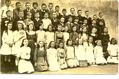 Federation University Historical Collection
Photograph - Photograph - Sepia, Students of Humffray Street State School No. 34, 1917, 1917 (original) 2112 (digital copy)
... . and his shop was an underground section. ballarat school of mines ...Ivy Wilson left Humffray Street State School and as a 12 year old enrolled at the Ballarat School of Mines Technical Art School. She studied Art there from 1920 to 1922. Ivy Wilson later became a successful dressmaker and was able to make her own patterns. Ivy's father was an orthopedic bootmaker. They lived at 17 Mair St. and his shop was an underground section.Sepia photograph showing a number of student of Ballarat's Humffray Street State School Grade Five pupils. The girl kneeling 4th from the right is Ivy Wilson.ballarat school of mines, ballarat technical art school, art, dressmaking, wilson, school, education