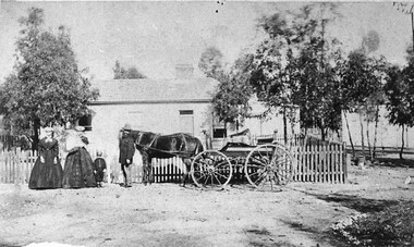
Showing 69 items matching "on-site dwelling"
-
 Orbost & District Historical Society
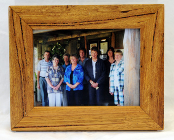
framed photograph, 14.4.2004
This photograph was taken on 14.4.2004 at the time of the visit to Orbost by the Governor of Victoria, John Landy.The Orbost Visitor Information Centre is situated in Forest Park on Nicholson Street. The centre is housed in the historic Slab Hut. The hut was an original family dwelling built in 1872, on a site approximately three kilometres upstream from the junction of the Buchan and Snowy Rivers. The Slab Hut is an Orbost Icon. It supports one part time manager and a team of dedicated volunteers.A coloured photograph in a wooden frame. A group of people stand in front of the Slab Hut (Orbost Information Centre) .On frame - NATURAL FEATURED HARDWOOD MADE BY 20.12.98 W. ASHLYN MARLO VIC.slab-hut-committee photograph -
 Orbost & District Historical Society
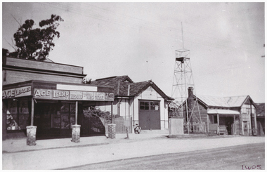
newspaper clippings, April, May 1987
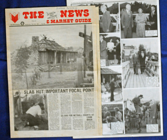
The Slab Hut (Orbost Visitor Information Centre) was opened on March 28, 1987. It was officially opened by Dr D. Caughey, the governor of Victoria. The Orbost Visitor Information Centre is situated in Forest Park on Nicholson Street. The centre is housed in the historic Slab Hut. The hut was an original family dwelling built in 1872, on a site approximately three kilometres upstream from the junction of the Buchan and Snowy Rivers. The Hut was removed from its original site around 1970, and stored until 1984 when the Shire Council approved the current site. It was restored and brought to life as a Tourist Information Centre in 1987.The Slab Hut is an icon of Orbost. These newspaper articles are contemporary records of the opening of this building.A selection of articles from The News and the Snowy River Mail. All relate to the opening of the Slab Hut, the Orbost Visitor Information Centre. They are photographs, information and the history of the Slab Hut.slab-hut-orbost newspaper-snowy-river-mail -
 Eltham District Historical Society Inc
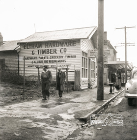
Photograph, Eltham Hardware and Timber Co, Main Road, Eltham, opposite Railway Station. c.1952, 1952c
The Eltham Hardware and Timber Company first opened on Main Road opposite the Railway Station around late 1922. An advertisement placed in the Hurstbridge Advertiser advised that the Hardware Store had just opened with a varied stock of Saws, Hammers, Nails, Shovels, Screw Drivers, and every article required in a house or on a farm. People were also encouraged to try their Jams, Pickles, Sauces, Cups and Saucers, etc. A few months later in May 1923, William Walker, a plumber, placed an advertisement wishing to to announce that he had taken over the ELTHAM HARDWARE STORE, and asked for the continued support of the district. He also noted that all kinds of Plumbing work was done. Walker remained the proprietor of the Hardware Store for many years regularly advertising its services and wares up until at least 1941. The trail goes a bit quiet then but he does appear in the 1944 Electoral Roll listed as a Plumber, of Main Street, Eltham. However he is not listed in the 1949 Electoral Roll but his son, Thomas Roy Walker, also a plumber of Main Road is listed. Thomas had been on active duty overseas during the Second World War and returned at the end of 1945. It is assumed that William died sometime between 1945 and 1949. On November 18th, 1950 the Hardware Store and residence was auctioned on site by Scarff Bros. Pty Ltd. It is presumed that this is when J.N. Burgoyne and Sons took over the business. It would have been around this time the picture of the store was taken for only three years later, in October 1953, the business and dwelling was again put up for sale, this time by Trebilcock Bros, in two separate lots. LOT 1. — ELTHAM HARDWARE AND TIMBER CO. Freehold and Property, Plant, Fittings and Business; Plus Stock at Valuation. To be Sold as a Going Concern. THE FREEHOLD PROPERTY Comprises Large Brick and Timber Shop. Well Fitted. Has Good Light. Comfortable 3-Room Dwelling and Detached Bungalow, H.W.S., Phone, Garage and Outbuildings. Situate on Large Allotment, 50 Ft. x 150 Ft. Aprox. THE BUSINESS: Flourishing Hardware and Builders’ Supplies, Crockery, Glassware and Gifts, Dry Cleaning Agency and Petrol Reseller Licence (1 Bowser Installed), Oil Storage. Annual Turnover Aprox. £12,000. Audited Figures Available, Old-established Business Comprehensive Stock is Good, Clean and Saleable (Value Approx. £4000). TERMS: £1000 Deposit, Balance 30 Days. VACANT POSSESSION. LOT 2. — Superb Shop Sites. Adjoining the Above Property. Land 58 Ft. x 150 Ft. (Approx.). Erected on Land Is Old Style 4-r Timber Dwelling, Set Well Back from Footpath. Leaving Ample Apace to erect Shops. Also Small Shop Let as Agent’s Office. To Be Sold Subject to Existing Tenancies, Gross Rentals £106 12/ Per Annum. Terms: £1000 Deposit, Balance 30 days. GENERAL: Eltham Is a Rapidly Developing Area only 12 Miles from G.P.O. Street Frontage of these Two Adjoining Properties Is 108 Feet By Depth of 150 Feet in the Heart of Expanding Shopping Centre, directly Opposite Station Entrance. Full Details and Inspection Available on Application from the Auctioneers: TREBILCOCK BROS. AUCTIONEERS and ESTATE AGENTS, Coincidentally, the Hardware Store was taken over by Richard Phillip Trebilcock, an electrical engineer from Mayona Road, MontmorencyNegative black and white film 120 6x6 formatSingle frameeltham, main road, 1951 chevrolet deluxe, ampol, eltham hardware and timber, j.n. burgoyne and sons, petrol bowser, william walker, richard phillip trebilcock -
 Federation University Historical Collection
Document - Reports, Martin Westbrooke, Nanya Station
... and rudimentary dwelling at the site of the present complex was later... and rudimentary dwelling at the site of the present complex was later ...Nanya Station, owned and managed by the University of Ballarat (now Federation University Australia), was purchased with assistance from the Department of Environment and Heritage Government Caring for our Country program. Nanya Station is located in the Scotia country, west of the Darling Ana-Branch in far western New South Wales and consists of the Nanya Western Lands Pastoral Lease 3281 – Perpetual Leasehold Lot 1244 in Deposited Plan 762778, Parish of Winnebaga, County of Tara and part of Lot 1242 County of Windeyer. Nanya is within the tribal area of the Danggali Aboriginal people, a sub-group of the Barkindji. Many Aboriginal sites have been recorded adjacent to major rivers in the region providing evidence that these areas supported a large population. The Scotia region has one of the shortest stock grazing histories of western NSW. Along with five other Scotia properties, Nanya was created as a pastoral lease in 1927. The first European settlement on the land followed exploration of the area by Sturt and Eyre. In 1854, the Lake Victoria lease which encompassed this area comprised 465,000ha.included Scotia blocks 1, 2, 3 and 4, Amoskeag and Winnebaga which formed the area known as the Scotia. It was described as a region of thick mallee scrub, interspersed with bluebush flats and Belah woodland. In the 1920s artesian water was found and the dry Scotia country was surveyed and divided into six Homestead leases allocated by ballot (Withers 1989). All properties were approximately 30,000ha, with a recommended stocking level of 3,000 sheep. Winnebaga (renamed Nanya) was taken up by Gordon Cumming. He initially dug a dam near the southeast corner of the property. A larger ground tank and rudimentary dwelling at the site of the present complex was later established. An adjacent area was cleared and cropped to provide feed for the horses used in digging the earth tanks. The ruins of the original building are located between the shearing shed and Homestead Tank. A cottage was built in the 1930s and a more substantial Red Gum framed homestead in the early 1950s. The lease was held by Mr Gordon Cumming until 1984 when it was purchased by Mr Norm Scadding as an extension to the adjacent lease, Belvedere. It was sold in 1995 to Mr Rob Taylor of Waikerie then in 1999 to BeMax Pty. Ltd., a sand mining company. These last three owners all permitted use of the property by the University for teaching and research. The Centre for Environmental Management at the University of Ballarat had been involved in studies of flora and fauna in western New South Wales since 1988. Studies became concentrated on the Scotia region with its variety of intact ecosystems due to a short pastoral history. Of particular significance is a system of natural salt lakes of which the most extensive is the Scotia Discharge Complex located on Nanya Station. An extensive vegetation survey of the Scotia region Westbrooke et al. 1998) highlighted the significance of the area both in terms of the range of communities in relatively intact condition and the occurrence of species and communities of restricted distribution. Nearly 400 species were recorded of which nine had either not previously been recorded or have restricted distribution in western NSW. Twenty-two plant communities occur on Nanya Station of which two, Halosarcia lylei low open shrubland and Hemichroa diandra/Halosarcia/Frankenia low open shrubland, are dominated by species not previously recorded from NSW. H. lylei and Acacia loderi shrublands are listed as endangered under the NSW Threatened Species Conservation Act. As noted, the area has a relatively short grazing history and, due to the presence of large areas of mallee with a Triodia understorey and restricted water supplies, stocking rates have been low. The diversity of ecosystems in relatively intact condition and extensive areas of old growth mallee made Nanya a highly significant refuge for biological diversity. This factors led to the purchase of Nanya Station by the University of Ballarat in 2004 with the assistance of the Department of Environment and Heritage for the purposes of conservation, research and education. In 2010 the southern paddocks of Nagaella Station (10,000ha.) which lie along the northern boundary, were purchased with the assistance of Lower Murray Darling Catchment Management Authority and added to the Nanya lease to provide complete protection for the communities of the Nanya Discharge Complex and further high quality Malleefowl habitat. Four digital reports documents relating to Federation University's Nanya Station, Western New South Walesnanya station, scotia country, pastoral lease, winnebaga county, darling ana-branch, martin westbrooke, environmental education, nagaella station, lower murray darling catchment management authority, conservation research education, ian gribble, pat prevett, ian henderson, danggali -
 Bendigo Historical Society Inc.
Newspaper - JENNY FOLEY COLLECTION: SPLENDOR
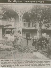
Bendigo Advertiser ''The way we were'' from 2000. Splendor: located at 12 Bannerman Street, Bendigo. R.A. Love designed this grand eight roomed, two-storey house for his neighbour, William Purcell in 1871. The sloping site has been excavated to the depth of one storey so the first floor is at ground level to the rear. The stone stables are now a separate dwelling. The clip is in a folder.newspaper, bendigo advertiser, the way we were -
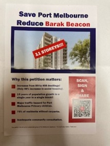 Port Melbourne Historical & Preservation Society
Flyer, Save Port Melbourne Reduce Barak Beacon, 2024
Flyer expresses residents concerns on proposed new increased heights and number of dwellings for the development which replace the low rise Ministry of Housing Sandridge Estate that had occupied the site since 1982.Half A4 size flyer has blue and red text on a white background and a photo of a tower block on the cover with '11storeys!!!'barak beacon, built environment - domestic -
 Bendigo Historical Society Inc.
Document - AILEEN AND JOHN ELLISON COLLECTION: BENDIGO HISTORICAL INFORMATION
9 pages document City of Bendigo historical information. After a brief description of the area, population, dwellings, city revenues, amount of gold and value of gold mined there is a timeline of the history of Bendigo starting in 1840 when the site of Bendigo was included in the Ravenswood run to 1891 when the city of Sandhurst changed to City of Bendigo. The following 8 pages dig deeper in the history starting with the find of the first gold nugget and describing the various industries that developed in the city. A description of the climate, agricultural activities, prominent people and buildings is also given.bendigo, history, city history -
Whitehorse Historical Society Inc.
Article, Set To Sell, 1/04/1992 12:00:00 AM
Residents surrounding the former site of the Warrawong Primary SchoolResidents surrounding the former site of the Warrawong Primary School have accepted the maximum 12% public open space with 15 dwellings per hectare development.Residents surrounding the former site of the Warrawong Primary Schoolvictoria. ministry of planning & housing, warrawong primary school, city of nunawading -
Whitehorse Historical Society Inc.
Article, Housing 'Monster' surprise, 2015
Whitehorse Council voted to approve a 118-dwelling development by Australia Hua Cheng Pty Ltd, Blackburn.Whitehorse Council voted to approve a 118-dwelling development by Australia Hua Cheng Pty Ltd, Blackburn, on the corner of Middleborough Road made up of two five-storey buildings and 15 double-storey buildings on the 7421 sm site.Whitehorse Council voted to approve a 118-dwelling development by Australia Hua Cheng Pty Ltd, Blackburn. city of whitehorse, massoud, denise, australia hua cheng pty ltd -
 Whitehorse Historical Society Inc.
Photograph, Warrender Hospital
Four copies of Warrender Hospital and Surgery run by Dr. Stanley Cochrane, Harrison Street- McDowall corner, Mitcham - site now occupied by R.S.L. Originally Dr. Cochrane's extremely large home the hospital became two private family dwellings when its activities as hospital ceased . Dr. Cochrane had consequently built a private residence/surgery on the corner of Mitcham Road and Harrison Street.warrender hospital, cochrane, stanley, dr., mitcham private hospital -
 City of Ballarat Libraries
Photograph - Card Box Photographs, 514 Wendouree Parade, Ballarat 1950
This brick house was built on the former site of Smith's Plant Nursery. It was owned at the time by J.A. Chisholm.wendouree parade, ballarat, private dwelling, building, garden, j.a. chisholm -
 City of Ballarat Libraries
Photograph - Card Box Photographs, Site of St Martins in the Pine circa 1880
... Building Vehicle Persons Private Dwelling Site of St Martins ...Pictured are the Fanning family who were toll-keepers. The property on Geelong Road is now St Martins in the Pines which was gifted to the Sisters of Mercy by Alice Fanning.st martins in the pines, alice fanning, sisters of mercy, building, vehicle, persons, private dwelling -
 Hume City Civic Collection
Photograph, The Nook, c1940
The Nook in Sunbury is situated on a wide and deep bend in Jacksons Creek. Today the area is a popular site for passive recreation with a walking path along the Jacksons Creek. The house on the RHS of the photograph was situated near Powlett Street.Before the Aquatic Centre was built in Sunbury the swimming pool at The Nook was the town's swimming pool for many years. Seats and a change area were at the site.A black and white photograph of a large bend in a river with a house built on its riverbank and another dwelling on the hillside in the middle distance.the nook, swimming, jacksons creek -
 Southern Sherbrooke Historical Society Inc.
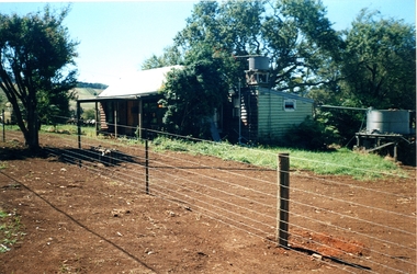
Information folder - Madigan Cottage
The buildings are probably rare remnant examples of their type in the local area and as such are significant to the settlement of Menzies Creek. The dwelling is significant as a longstanding marker of the Madigan family who were original settlers in the area. Its retention in its site close to the road boundary expresses and maintains a connection with early settlement and rural lifestyles in Menzies Creek over the last century. The old shed is of interest as a local example of bush construction, particularly in context with the cottage and farm environs. Without the life of the farm and other elements presumed now gone, its value is lessened.Folder containing information pertaining to the history of Madigan Cottage, Menzies Creek. NB: the shed was demolished in November 2001 and the cottage burned down sometime later. Contents:- Letter, Southern Sherbrooke Historical Society to Shire of Yarra Ranges, dated 9th March 2001, re. sale of property and need for it to be included in shire's Heritage Study. -Letter, shire to society, dated 20th March 2001, reply to above. -Letter, shire to society, dated 15th May 2001, follow-up to above, requesting more information. -Letter, society to shire, dated 30th May 2001, responding to above and including a copy of information previously sent to Chris Johnston, Heritage Study consultant. -Letter, society to shire, undated, noting intention to lodge an objection to proposed application for development on site. -Letter, shire to society, dated 22nd October 2001, advising of consultation meeting. -Yarra Ranges Shire Heritage Study Place Nomination form for Madigan Cottage, prepared by Marian Matta, includes nine colour photos and diagram showing where photos were taken from. -Black and white copies of photos. -A3 copy of real estate advertisement, "Mount Evergreen Estate" dated 21st April 1924. -A3 map showing proposed resubdivision boundary variation, drawn up for Mr. P. Melville, undated but 1990s. -Copy of application for a planning permit, dated 6th August 2001, including letter by Nick Jonkers describing proposed new buildings, site map showing current vegetation, letter re. proposed removal of vegetation, subdivision plan dated March 1998, and larger scale map printed from shire website on 10th August 2001. -5 A3 sheets showing site and house plans drawn up for Mr & Mrs N. Jonkers, dated July 2001.madigan cottage, menzies creek, madigan family, mount evergreen, patrick madigan -
 Surrey Hills Historical Society Collection
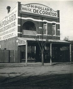
Photograph, Shop of J H Pollard, House Decorator, at 139 Union Road, Surrey Hills, 1930
This site was later occupied by Mitton's pharmacy. James Henry Pollard appears on the 1903 electoral roll as a painter in Canterbury Road (in one of the buildings that made up Hansen's Terrace.)The Union Road shops are covered by a City of Boroondara Heritage Overlay. This particular shop has changed very little with some alteration to the upper storey when it was repurposed for residential dwelling.Black and white photo of James Henry Pollard's shop at 139 Union Road, Surrey Hills in 1930. It is a 2 storey brick building with 2 glass display windows either side of the door and a corrugated iron roofed verandah supported on 3 posts. Above is a dwelling with 2 sash windows and an interior balcony within an arch. A wooden paling fence adjoins on the left. The side of the building and the front pediment carry advertising for the business. From this it appears that James Henry Pollard was an insurance agent for Guardian Assurance Company as well as being a house painter and decorator. There is a deciduous tree in the front of the shop.businesses, shops, mitton's pharmacy, guardian assurance company, union road shops, james henry pollard, painter, decorator -
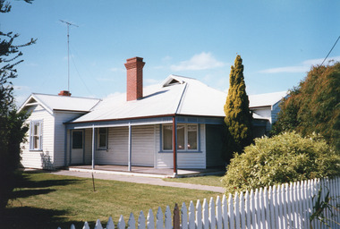
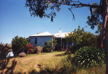
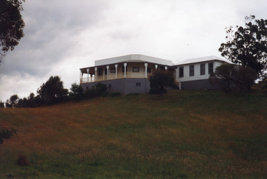
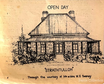 Melton City Libraries
Drawing, Open Day at Strathtulloh, Unknown
"Strathtulloh, 1402-1600 Greigs Road, Melton South, is significant as an early property in Victoria, retaining different eras of pioneering dwellings, ranging from a ruin to a fine Colonial style homestead. The property has close historical association with the early settlement of the Melton district, and was owned by the Henty family in the 1840s. The Strathtulloh property was alienated by the Crown in 1840 to Charles James Garrard, who sold it in 1848 to Charles and Stephen Henty, whose sister Jane and her husband Samuel Bryan lived there in the late 1840s. In 1853 the property then passed to William Tulloh, after whom the homestead was named. A primitive bluestone ruin of near the Toolern Creek, built of vesicular bluestone and mud mortar, is of unknown origin. It has commonly been assumed to pre-date 1840, and to have belonged to the original holder of the Exford lease, Dr Watton or Port Phillip Association member Dr Cotterill. This is unlikely, as the 1841 census records Dr Watton, and everyone else in the district, as living in a ‘wood’ dwelling. It may instead have been the residence of Garrard, and the Bryans, in the 1840s and an early map names a site near here as ‘Bryan’s outstation’. It is assumed that the two-level stone building that became the kitchen is the earliest intact building on the site, and was the first homestead; it is likely to date to the 1840s or 1850s. The main homestead is a substantial villa constructed of random coursed bluestone, with a verandah facing three sides, attic bedrooms with dormer windows, a fan light over the front door, a hipped roof originally clad in slate, and a large cellar. Although demonstrating characteristics of pioneering construction, such as unworked log beams, pit sawn beams, hand-sawn lintels and colonial door locks, documentary evidence shows that it was built c.1869. The homestead has now been structurally repaired and decoratively restored; a sympathetic new semi-detached rear extension was added in the early years of the 21st century. The former kitchen building has also undergone minor repairs and alterations". Strathtulloh Homestead at 1402-1600 Greigs Road, Melton Southlocal architecture -
 Lakes Entrance Historical Society
Photograph - Historic House, Holding M, 2000
Private residence built 1925c for Frank Harbeck|Also Two other colour photographs showing two brick chimneys left standing until site cleared for construction of holiday accommodation.Colour photograph of a dwelling at 55 Church Street, prior to demolition. Weatherboard building, iron roof, gable projection. NW and SE corners, gable ventilator in centre roof, veranda on two sides. Bay window across corner of front room. Lakes Entrance Victoriahouses, local history -
 Lakes Entrance Historical Society
Photograph - Bunga Haven, 1999
Built on site of Northrope's original bark residence (1890c).Colour photograph of a property known as Bunga Haven at 127 Lake Bunga Road. A timber dwelling with corrugated iron roof overlooking Lake Bunga and Bass Strait. Set in rustic garden and native bushland. Dropped log boundary fence and brush gate. Lakes Entrance Victoriaaccommodation, tourism -
 Lakes Entrance Historical Society
Photograph - Housing, 1999
Known as Powerlot, built by George Packer, a local builder for Jim McLaughlin in 1914. During Olsen family ownership house was altered. The two acre site once had landscaped garden and orchard. Flat roof has lead lined walkway for viewing lakes and sea. Story goes 'The German raider Wolf was observed signalling during WW1'.Colour photograph of a white painted timber dwelling set on a high vantage point at Stirling Road consisting of two wings, one with flat roof and veranda on three sides, the other more recently built has hipped roof. Metung Victoriahouses, heritage study -
 Linton and District Historical Society Inc
Photograph, Murrell's Newsagency, Sussex Street, Linton, circa 1940
William Murrell ran a newspaper shop on the west side of Sussex Street until 1932, when he moved his business to a site formerly occupied by Dan Cornish (who ran it as a shoe shop). After William Murrell died the newsagency was run for many years by his daughter Carrie Murrell.Black and white photograph which shows buildings along the east side of Sussex Street, including Murrell's newsagency, the fire brigade building, and another shop or dwelling.murrell's newsagency, linton fire brigade building, buildings, shops, sussex street linton -
 Lakes Entrance Historical Society
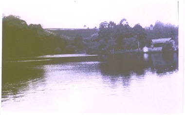
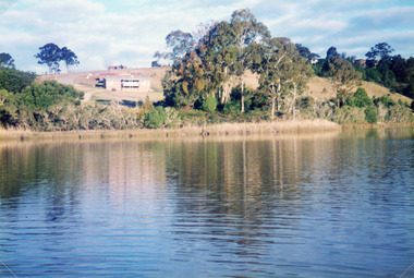
Photograph - Tarra Landing, Davies, Judy, 1996c
Colour photograph of Tarra Landing, North Arm. It shows a road and dwelling of the new housing development above the lake. Reflections of natural vegetation in lake. Lakes Entrance Victoriahistoric sites, land development -
 Eltham District Historical Society Inc
Negative - Photograph, Old house (now demolished), Eltham North Reserve, Wattletree Road, Eltham North, 1998c
"Nillumbik Shire Commissioners will tonight consider what to do with a weatherboard dwelling on Wattletree Rd., Eltham North, which it regards as an "eyesore". "The property has a long and infamous history as an administrative headache, a pattern which has been maintained in recent months." says a report on the Council-owned house. It is likely tenders will be called to removed the house from the site". - The Advertiser, Tuesday, November 14, 1995. page 19 The house was the subject of a painting by John Wakefield entitled "Vale, Eltham North" in the collection of Nillumbik Shire Council. Roll of 35mm colour negative film, 8 strips and associated 10 x 15 cm colour printKodak Gold 100-5john wakefield, eltham north reserve, wattletree road -
 Lakes Entrance Historical Society
Photograph - Historic House, Bennett, Vera, 1991
Date made May 1991|Old building demolished c2008. Ostler family arrived at Cunninghame (Lakes Entrance) by boat, walked to the site with their belongings, cleared the land, built a dwelling, farmed dairy herd, grew maize, had beehives.| Also one colour photograph of new dwelling constructed next to the old dwelling taken 29th September 2007|Also two other colour photographs old dwelling.Colour photograph of Ostlers old home, 106 Ostlers Road, showing a timber and corrugated iron structure amongst farm buildings and trees. Lakes Entrance Victoriahouses, local history -
 Eltham District Historical Society Inc
Photograph - Digital Photograph, Alan King, Panton Hill Primary School, 27 March 2008
The Panton Hill Primary School building, which has served the community since 1889, was not the area's first. Kingston School (an early name for Panton Hill) opened in May 1865. This was replaced in 1871 when the Panton Hill School number 1134 opened and in 1874 the school moved to its current location [September 2023] where many additions and renovations have taken place to meet the needs of local children in the 21st century. Covered under Heritage Overlay, Nillumbik Planning Scheme. Published: Nillumbik Now and Then / Marguerite Marshall 2008; photographs Alan King with Marguerite Marshall.; p63 The Panton Hill Primary School building, which has served the community since 1889, was not the area’s first. In 1871 Henry Edelman opened a Common School in a paling-clad hut, replacing the Kingstown No 786 school. The two-acre (0.8ha) site of crown land had previously been held under Miners Right. In 1875 the Education Department bought a building on the main road for State School No 1134, for £200 and remodelled it as a school.4 Panton Hill had as one of its teachers, Frank Tate, who was to become one of Victoria’s most influential educational reformers. It was his first school, when he began teaching on January 22, 1884, as a 20 year old.5 The following month Robert J Harris was appointed to the school and remained as head teacher until his death in 1887. His son R C Harris was apprenticed to Mr Rossiter, editor of the first local paper. The Evelyn Observer, first published in 1873. Harris later bought the newspaper which remained a family business until the 1920s. J Hughes of Cherry Tree Road succeeded Harris as teacher at Panton Hill and sold his land for the school site. Though now unrecognisable, the school building includes the classroom of the last Smiths Gully State School No 1737, which was built in 1882, and moved to Panton Hill in 1894. From 1922 each school day began with the ringing of the bell, which is still in its stand, and is an unusually old memorial of this kind. To accommodate the growing population, the building was remodelled, with additions in 1923 and classrooms were added in 1955, 1963 and 1970. The former teacher’s residence is the only surviving 19th century dwelling in the centre of Panton Hill, and is now used as part of the school. The residence was originally rectangular but is now L-shaped. Similar weatherboard State School buildings in the shire from this period are the Kangaroo Ground and the St Andrews Primary Schools. All were standard Education Department/Public Works Department designs.This collection of almost 130 photos about places and people within the Shire of Nillumbik, an urban and rural municipality in Melbourne's north, contributes to an understanding of the history of the Shire. Published in 2008 immediately prior to the Black Saturday bushfires of February 7, 2009, it documents sites that were impacted, and in some cases destroyed by the fires. It includes photographs taken especially for the publication, creating a unique time capsule representing the Shire in the early 21st century. It remains the most recent comprehenesive publication devoted to the Shire's history connecting local residents to the past. nillumbik now and then (marshall-king) collection, panton hill primary school -
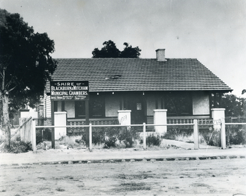 Whitehorse Historical Society Inc.
Photograph - B/W Photograph, Municipal Chambers - Shire of Blackburn & Mitcham - First Office
When the Shire of Blackburn and Mitcham was proclaimed on 27th May 1925, the second meeting of the Shire was held in the hall of the Methodist Church on Monday 28th September 1925 at 7.30pm.|Three ensuing meetings were also held there and following meetings were at the dwelling in Whitehorse Road, which was purchased by the Shire for use as their office. (By Coincidence this dwelling was almost on the site of their new Municipal Offices.)Black and white picture - Municipal Chambers of Shire of Blackburn & Mitcham located opposite the present offices of City of Whitehorse in Whitehorse Road, Nunawading|See also NP35 & NP36 after it was destroyed by fire.municipal chambers - first office, shire of blackburn and mitcham, whitehorse road, nunawading, methodist church -
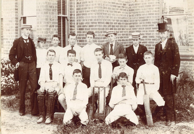 Surrey Hills Historical Society Collection
Photograph - Surrey College Cricket Team, 1899, 1899
Surrey College was opened in early 1892 by Reverend Dr Frederick Darling who had been the first minister of the Presbyterian Church in Canterbury Road. He resigned this position to open the school which operated until 1905 with additional premises at 12 Vincent Street. The main building fronted 219-233 Union Road. The school had 40 boarders as well as day boys. Courses included algebra, euclid, history, typewriting, shorthand and drill. In the 1930s, Nethercourt Private Hospital took over the site. Later it became St Jude's Hospital. Land in front of the building was sub-divided off in the 1970s. The building is still extant as a private dwelling with York Street, Surrey Hills as the address. This is one of 3 photos donated by Susan Hobbs, whose grandfather Rev. George Edward Downton is thought to have been a student at the college. George E. Downton was born in Avoca in 1885. He was later a missionary in New Guinea and Secretary to the Australian Board of Missions in Adelaide. He died in 1926 or 1927. This photo is one of two that were originally in the Box Hill Historical Society collection. They were transferred to us in 2024. The third photo could not be located. There was also a rough family tree and notes for the Downton family with correspondence regarding the donation but this was not found.Sepia photograph on grey mount board of 15 men and boys. Eleven of the boys are dressed in whites, 5 wearing ties and 1 a bow tie, one with a boater and one with a cap. The boy seated on the right is holding a cricket bat and the boy seated on left is wearing cricket pads on his legs. There are stumps and bails in the middle of front row. Three young men are in suits and boaters with one in the back row holding items in his hands. On the right hand side of the back row is Reverend Frederick Darling, Principal of the College, who wears a top hat and tails. There is a brick building behind with windows and blinds, and some foliage and plants behind and in front of boys. "Surrey College - Surrey Hills/Principal: Rev Fredk. A Darling, Melb. Unib./Cricket Team, 1899"schools, sport, cricket, 1899, surrey hills, surrey college, rev frederick a darling, george edward downton, susan hobbs, union road, nethercourt hospital, st jude's hospital, 219-223 union road, york street, 1890-1899 -
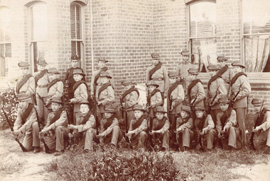 Surrey Hills Historical Society Collection
Photograph - Surrey College Cadet Corps, 1899, 1899
Surrey College was opened in early 1892 by Rev. Dr Frederick Darling who had been the first minister of the Presbyterian Church in Canterbury Road. He resigned this position to open the school which operated until 1908 with additional premises at 12 Vincent Street. The school had 40 boarders as well as day boys. Courses included algebra, euclid, history, typewriting, shorthand and drill. In the 1930s, Nethercourt Private Hospital took over the site. Later it became St Jude's Hospital. land in front of the building was subdivided off in the 1970s. The building is still extant as a private dwelling with York Street, Surrey Hills as the address. This is one of 3 photos donated by Susan Hobbs, whose grandfather Rev. George Edward Downton is thought to have been a student at the college. George E. Downton was born in Avoca in 1885. He was later a missionary in New Guinea and Secretary to the Australian Board of Missions in Adelaide. He died in 1926 or 1927. Sepia photo of 26 men and boys dressed in military uniform, many holding rifles. They are standing in front of a brick building with bay windows with blinds and curtains. There is a clump of foliage and grass in front of boys. "Surrey College - Surrey Hills / Principal: Rev Frdk. A. Darling, Melb. Univ./Cadet Corps, 1899." On the mount below the photo. Inscription on bottom right hand corner of photo: "Prepare for cavalry"schools, 1899, surrey hills, surrey college, rev frederick a darling, george edward downton, susan hobbs, union road, nethercourt hospital, st jude's hospital, 219-223 union road, cadet corps, 1890-1899 -
 Lakes Entrance Historical Society
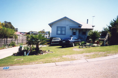
Photograph - Housing, Holding M, 1999
Appears to have been relocated from unknown site, more research required.Colour photograph of a timber dwelling. Has high pitched corrugated iron roof, decorative timber frieze under pitch of gable over front room. Steps leading up to veranda. Set in native vegetation, at 6 Worcester Street, Lakes Entrance Victoriaaccommodation, houses, heritage study -
 Lakes Entrance Historical Society
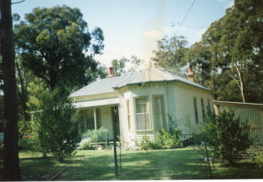
Photograph - Housing, 1999
More research required. Where it was originally located is unknown.Colour photograph timber dwelling with corrugated iron roof, fibro clad under gable projection. Sash windows have four panes in top window. Was relocated from a site in business centre. Situated at 11 Ocean Court, Lakes Entrance Victoriahouses, heritage study -
 Lakes Entrance Historical Society
Photograph - Housing, 1990
Moved to present site 1989c by Tony TrompColour photograph of a single storey timber dwelling with corrugated iron hipped roof, bay window at front room, veranda on two sides, unique sunshade over SW window, internal chimneys with chimney pots. Set in bushland with native plant garden, at 357 Lake Tyers Beach Road. Painted cream with fawn trim. Relocated from Esplanade. Lake Tyers Beach Victoriahouses, architecture