Showing 297 items
matching open spaces
-
 Whitehorse Historical Society Inc.
Document, Open space between Yarran Dheran and Schwerkolt Cottage, 2001
... Open space between Yarran Dheran and Schwerkolt Cottage...Report of an open space assessment by Melbourne Parks... Report of an open space assessment by Melbourne Parks ...Report of an open space assessment by Melbourne Parks and Waterways land between Yarran Dheran and Schwerkolt Cottage.Report of an open space assessment by Melbourne Parks and Waterways land between Yarran Dheran and Schwerkolt Cottage. Council Paper PROP/016781Report of an open space assessment by Melbourne Parks and Waterways land between Yarran Dheran and Schwerkolt Cottage. yarran dheran, nunawading and district historical society inc., schwerkolt cottage -
 Whitehorse Historical Society Inc.
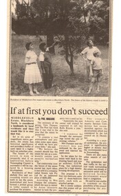
Article, If at first you don't succeed, ca 1985
... Estate, Blackburn North as a buffer of open space in highly built... to maintain Middlefield Estate, Blackburn North as a buffer of open ...Article reporting community desire to maintain Middlefield Estate, Blackburn NorthArticle reporting community desire to maintain Middlefield Estate, Blackburn North as a buffer of open space in highly built up suburban area.Article reporting community desire to maintain Middlefield Estate, Blackburn Northland subdivision, middlefield estate, blackburn north, middlefield drive, dunque, vera, streets ads pty ltd, fong, g.o.w., city of nunawading. amenity and community services committee -
Whitehorse Historical Society Inc.
Newspaper, Land Auction, 29/04/1992 12:00:00 AM
... agreed to 22% Public Open Space.... Plant. State Government agreed to 22% Public Open Space. Land ...The Site of the former Middlefield Primary School is to be Auctioned on 12th May, 1992,The Site of the former Middlefield Primary School is to be Auctioned on 12th May, 1992, by Barry Plant. State Government agreed to 22% Public Open Space.The Site of the former Middlefield Primary School is to be Auctioned on 12th May, 1992,middlefield primary school, auctions, primary schools -
Whitehorse Historical Society Inc.
Article, Reserve balance is right: residents, 2014
... Open space and housing balance proposed by the Whitehorse... VicRoads City of Whitehorse Open space and housing balance proposed ...Open space and housing balance proposed by the Whitehorse Council.Open space and housing balance proposed by the Whitehorse Council has been approved by many residents and Friends of Healesville Freeway Reserve. The Nunawading Community Gardens will be retained.Open space and housing balance proposed by the Whitehorse Council. nunawading community gardens, friends of healesville freeway reserve, makhijani, anne, healesville freeway reserve, vicroads, city of whitehorse -
Port Melbourne Historical & Preservation Society
Plan, Bay Street, C. 1990
... , verandah changes, proposed open space & building use.... suggestions for tree planting, verandah changes, proposed open space ...A proposed plan for the development of Bay Street, Port Melbourne. The Street plan shows suggestions for tree planting, verandah changes, proposed open space & building use.bay street, built environment - commercial -
 Surrey Hills Historical Society Collection
Photograph - Mrs Long's house, Delta Street area, Surrey Hills
... as open space.... in the background but part of the area remains as open space. Photograph Mrs ...The property is in the area that later became Delta Street, on the north side of Back Creek. Once roads were made and streets numbered, this became 1 Delta Road, Surrey Hills. Part of the undeveloped land would become part of South Surrey Park. According to Alan Holt's property register the house was built in c1920 and was demolished after having been neglected in 1991. He records it having had various names: 'Westward Ho', 'Pembroke' and 'The Oaks'. The first owner from 1920 was Eric Rowland Handyside Long who married Agnes May Hay Murray in March 1920. They had one son James Murray Long, born in September 1921. They divorced in 1937 and thereafter the property is listed in the name of Mrs Mary Hay Long, James M Long or Miss Mary Hay Long. According to Alan Holt, the house featured in the television series 'Carson's Law' in c1984.This is one of relatively few photos which record the transformation of rural land into the suburb that became Surrey Hills.A simple dark-stained timber house with a veranda and tiled roof. It is simply fenced with posts and wire mess. There are other houses in the background but part of the area remains as open space.delta road, back creek, south surrey park, wetward ho, pembroke, the oaks, hose names, miss agnes may hay murray, mrs agnes may hay long, mrs mary hay long, miss mary hay long, james murray long, carson's law -
Port Melbourne Historical & Preservation Society
Plan, Bay Street Site Analysis, C. 1990
... planting, verandah changes, proposed open space & building use...., proposed open space & building use. Bay Street Site Analysis Plan ...A site analysis plan for the development of Bay Street, Port Melbourne. The Street plan shows suggestions for tree planting, verandah changes, proposed open space & building use.bay street, built environment - commercial -
 Surrey Hills Historical Society Collection
Photograph, Land in Everton Grove, Surrey Hills in 1927, 1927
... boy are playing in the open space.... in the open space. Land in Everton Grove, Surrey Hills in 1927 ...The vacant land was the site of Norman Carter's future home at 21 Everton Grove. Norman Broadley Carter (1899-1984) married Mabel Annie Moore in 1927. Norman was an engineer with a passion for photography. Norman took many photos of Surrey Hills and Mont Albert from the 1920s and particularly of events and activities of the Church of England. For many years the house on the left located at 14 Harding Street belonged to the Kenneth Rothwell Culliton and his wife (Fanny) Molly Culliton. The house is located next to the Harding Street Reserve. Ken was an engineer and Molly was an early member of the Surrey Hills Historical Society. Ken was born and died in Surrey Hills. His father Harry Culliton was a well known golfer. His mother Christina Mary Rothwell was the daughter of Thomas Talbot Rothwell, known as a tea merchant and importer; also lived in Surrey Hills. This image is significant for its documentation of pre-urban Surrey Hills.Black and white photo of an area of gently sloping mown grass. On the horizon is a line of trees and on the LHS the outline of a (?) Victorian house can be seen. A man and a young boy are playing in the open space.everton grove, harding street, kenneth rothwell culliton, miss fanny molly arthur, mrs fanny molly culliton, norman broadley carter, mabel annie moore, mabel annie carter -
Whitehorse Historical Society Inc.
Newspaper, Petitioners Say Their Call Is Going Unheard, 4/11/1992 12:00:00 AM
... for Public Open Space.... of the former Middlefield Primary School for Public Open Space ...A Petition signed by 550 Local Residents has been delivered to the Minister for Finance and Member for Mitcham, John HarrowfieldA Petition signed by 550 Local Residents has been delivered to the Minister for Finance and Member for Mitcham, John Harrowfield, seeking retention of part of the former Middlefield Primary School for Public Open Space.A Petition signed by 550 Local Residents has been delivered to the Minister for Finance and Member for Mitcham, John Harrowfieldharrowfield, john, mckittrick, david, pescott, roger, middlefield primary school, primary schools -
 Whitehorse Historical Society Inc.
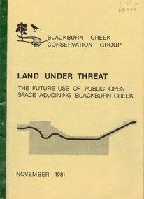
Document, Land under threat, 1981
... 'Land under threat: the future use of public open space...: the future use of public open space adjoining Blackburn Creek ...'Land under threat: the future use of public open space adjoining Blackburn Creek' by Blackburn Creek Conservation Group, November 1981.'Land under threat: the future use of public open space adjoining Blackburn Creek' by Blackburn Creek Conservation Group, November 1981. Includes detailed descriptions, plans, bird lists, correspondence.'Land under threat: the future use of public open space adjoining Blackburn Creek' by Blackburn Creek Conservation Group, November 1981.blackburn creek, parks and reserves, kalang park, furness park, environment, blackburn creek conservation group, blacks walk, blackburn creeklands, melbourne and metropolitan board of works, city of nunawading, burgess, graham -
Whitehorse Historical Society Inc.
Map, M.M.B.W - Schwerkolt Cottage, 30/04/1968
... , open space, residential zones C & D and location of Schwerkolt... showing proposed main road, open space, residential zones C & D ...Extract from M.M.B.W. map No 79 showing proposed main road, open space, residential zones C & D and location of Schwerkolt Cottage. Approved 40/04/1968. 2 copiesschwerkolt cottage, melbourne and metropolitan board of works, eastern freeway -
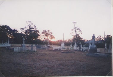 Sunbury Family History and Heritage Society Inc.
Photograph, Lydia Keyworth, Sunbury Cemetery, March 2001
... with a number of old graves scattered across the open space. Some have... landscape with a number of old graves scattered across the open ...The photograph of Sunbury Cemetery at sunset was entered into the Photograph Competition organised by the former Sunbury & District Heritage Association in March 2001.In 1862, land set aside in Cemetery Road for the Sunbury Cemetery was laid out in the following Christian denominational groups, Church of England, Roman Catholic, Baptist, Methodist, Presbyterian and Lutheran. Other non-denominational sites were set aside for paupers, heathens, Asians and pagans. Rebecca Jenkinson was the first person to be buried there in 1862. Over the years the size of the cemetery has expanded but it still occupies the original site off Shields Street in Sunbury and the names of the denominational divisions have changed over the years reflect a more inclusive outlook.Sunbury Cemetery replaced other smaller graveyards that were situated in some of the local church grounds and the earlier cemetery that was at The Gap township.A non-digital coloured photograph of a cemetery landscape with a number of old graves scattered across the open space. Some have small fences around them, while others simply display the headstones. There are trees in the background. sunbury cemetery, shields street, cemetery road, sunbury, cemeteries -
 University of Melbourne, Burnley Campus Archives
Plan, Master Plan Burnley Gardens, c.1996
... Institute) and V.C.A.H. Buildings and Open Space areas. Map used... Research Institute) and V.C.A.H. Buildings and Open Space areas ...Plan of Burnley Gardens showing P.R.I. (Plant Research Institute) and V.C.A.H. Buildings and Open Space areas. Map used - photogrammetric plot prepared for the V.C.A.H. By Stereometric Services from aerial photography taken 10-7-1988.vcah, burnley gardens, stereometric services, master plan -
 Bayside Gallery - Bayside City Council Art & Heritage Collection
Map - print, Melbourne and Metropolitan Board of Works, Interim development order: Brighton, Moorabbin and Sandringham, 1959
... , industry, transportation. It also shows open spaces, public..., industry, transportation. It also shows open spaces, public ...The Melbourne and Metropolitan Board of Works (now Melbourne Water) was established in 1891. From that time, as part of their work laying water and sewerage connections, they created detailed plans of houses and other buildings in the Melbourne metropolitan area. In 1956 it acquired powers to construct and maintain highways and bridges, protect and improve the foreshores and create and maintain parks within the metropolitan region. This Interim development order comprises part of the municipalities of Brighton, Moorabbin and Sandringham and was made on 20 October 1959.brighton, moorabbin, sandringham, melbourne and metropolitan board of works, map, town planning, cartographic material, interim development order, bayside -
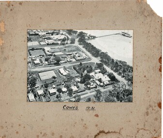 Phillip Island and District Historical Society Inc.
Photograph, Aerial photo Cowes 1931, 1931
... and open space.... with large tennis courts and open space. Historical Cowes aerial ...Cowes in the era of guesthouses with large tennis courts and open space.HistoricalBlack & white photo mounted on cardboard of Cowes jetty with boats, Thompson Ave, The Esplanade, Isle of Wight, The Continental Guesthouse, Erewhon Guesthouse, Yackatoon Guesthouse.Cowes 1931cowes, aerial photos, jetty, isle of wight, continental, yackatoon, guesthouses, bass avenue -
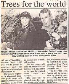 Ringwood and District Historical Society
Newspaper, Scrapbook Clipping, Library Collection, Ringwood, Victoria, `
... and open space areas throughout Maroondah City..... The trees will be planted on roadsides and open space areas ...``Newspaper clipping from "The Post", 14-6-95, P 11. Trees for the world Maroondah Council parks crew members Karyn Stewart and Lance Fraser with a few of the 2500 trees they will help plant for World Environment Week. The trees will be planted on roadsides and open space areas throughout Maroondah City.` -
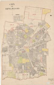 Ringwood and District Historical Society
Map, City of Ringwood - Rateable Properties Layout - c.1966. Overlay showing Reserves, Open Space, Playgrounds, and Schools
... . Overlay showing Reserves, Open Space, Playgrounds, and Schools.... Rec Reserves, Existing Open Space, Children's Playgrounds... Rec Reserves, Existing Open Space, Children's Playgrounds ...A0-size (approx) map of named streets, lot-numbered properties and locality features within City of Ringwood boundary. Colour-coded legend identifying Existing Rec Reserves, Proposed Rec Reserves, Existing Open Space, Children's Playgrounds, and Schools.Scale: 8 chains to 1 inch. Map picked up in Engineer's office at old town hall prior to demolition 1971. -
 Surrey Hills Historical Society Collection
Photograph, Back Creek (later South Surrey Park), c 1936, 1936
... Street. Some of their backyards face onto the open space along... the open space along the creek bed. Back Creek (later South Surrey ...This photo was taken at the opening of the footbridge by Sir Winston Dugan in 1936.South Surrey Park was developed on land which had been the property of the Kleinert family. Their land extended from Union Road to Essex Road. They ran horses, ducks and fowls and Emily Kleinert grew flowers. Alan Holt research: Lot 6 was sold to Martin Klienert by Karl Richter in 1860 together with a portion of another adjacent lot. From 1860-1885 Martin worked it as a market garden leasing some land for grazing when it was not required for gardening. He died in 1898. In a formal document, William declared he was the son of Martin "who purchased land in 1860, died in 1898 and the land has been continually occupied by father and family since. It has been cultivated as a market garden; when not being used for gardening it was let for cultivation and grazing." William died in 1939 and the property passed to his sons Martin and Ernest. The family sold the land to the Camberwell Council in the 1950s.This photo is significant as it shows the transition from rural to urban land use in Surrey Hills.Black and white photo taken in the area later known as South Surrey Park. Back Creek is in the foreground. There is a tent on the LHS and approximately 7 houses which front Verdun Street. Some of their backyards face onto the open space along the creek bed.parks and reserves, creeks, south surrey park, civic occasion, official events, back creek, verdun street, 1936, kleinert family, sir winston dugan, topography -
Whitehorse Historical Society Inc.
Map, City of Nunawading, 1973
... Map showing streets, plot numbers, schools, open space..., plot numbers, schools, open space and land usage. Map showing ...Map showing streets, plot numbers, schools, open space and land usage.Map showing streets, plot numbers, schools, open space and land usage. A project by A Gray, student at Vermont High School. Area covered from Canterbury Road to Burwood Road and Terrara Road to Morack Road. Scale: 800 ft: 1 inchMap showing streets, plot numbers, schools, open space and land usage.vermont south, vermont, vermont high school, parks and reserves -
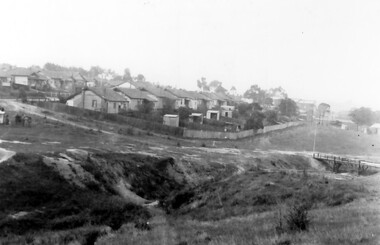
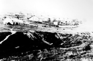
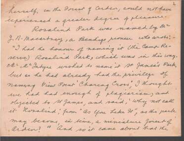 Bendigo Historical Society Inc.
Document - PARKS OF BENDIGO: HANDWRITTEN STORY
... of open spaces and municipal reserves.... of open spaces and municipal reserves. Document PARKS OF BENDIGO ...Parks of Bendigo (handwritten story re the various - Untitled). This is a 17 page handwritten summary of the various park areas of Bendigo with reminiscences and history . By unknown author (Lucy Hill??), no date. Missing two pages, #1 and #13. Mentions: Rosalind Park, Botanical Gardens, and a number of open spaces and municipal reserves.bendigo, parks and gardens, rosalind park, rosalind park, botanical gardens -
 Surrey Hills Historical Society Collection
Photograph, 'Glenisla', 18 Chestnut Street, Surrey Hills, c 1920, 1920
... areas of open space around the house.... garden. There appears to be significant areas of open space ...Date is approximate. In 1920 this became the home of Mr and Mrs Robert Moore, whose daughter Mabel Annie married Norman Brodley Carter of Mont Albert. The house was named after 'Glenisla', a western District grazing property located between Hamilton and Horsham on the Henty Highway and on the edge of the Grampians National Park. This was established as a super-fine wool stud in 1860 and was passed down the family until it was sold in 1922. The family transferred from this property to Melbourne. Robert is listed as a grazier in the 1924 electoral roll at Chestnut Street. With him are Victor Cecil listed as a carpenter; Isabella, Mabel Annie and Edgar Gilbert listed as an orchardist. In 2003 the house was extant minus the verandas. This photo may have been taken from the rear of the property. Ref: History of original property - Age newspaper article: 'The Best - Glenisla: historic Grampians property', 7 January 1994. Moore family details: Robert Moore born 1857 on Isle of Man; died Surrey Hills 1940 Isabella Bateson born 1869; died Surrey Hills 1938 Married in 1894 in Miram, 10 km north-east of Kaniva in the northern Wimmera. All the children were born in Kaniva. Children: Lena Florence (1895-1980) Victor Cecil (1896-1984) - a builder Edgar Gilbert (1897-1976); died Surrey Hills; married Myrtle Emary, daughter of Henry John Emary of Surrey Hills Ernest Alan (1900-1900) Mabel Annie (1901-1957); died Surrey Hills married Norman Brodley Carter (1899-1984) Clarence Arthur (1904-2004). Norman Carter took many photos in the Surrey Hills and Mont Albert are from the 1920s; many is connection with Church of England events and activities. Robert and Isabella Moore are buried in Box Hill Cemetery. Black and white photo of a Victorian home with a veranda with a corrugated iron roof and lacework on 2 sides. It appears to have a later extension at the rear. It is surrounded by mature gardens with ornamental trees (cypresses) and an area with plants in rows, which may be a vegetable garden. There appears to be significant areas of open space around the house.glenisla, homes, victorian style, gardens, norman carter, robert moore, miss isabella bateson, mrs isabella moore, victor cecil moore, edgar gilbert moore, miss mabel annie moore, box hill cemetery -
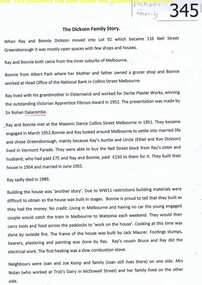 Greensborough Historical Society
Oral History, The Dickson family story, 1952o
... , the area was mostly open space with few houses. Bonnie recalls... to Greensborough in 1951, the area was mostly open space with few houses ...Ray and Bonnie Dickson moved to Greensborough in 1951, the area was mostly open space with few houses. Bonnie recalls and recounts her life in Greensborough in this interview with neighbour Rosalie Bray.There is some discussion of restrictions to house building in this post war period.3 typed pages of oral history and photograph of Bonnie Dickson. Copy 2: Item 695.bonnie dickson, ray dickson, rosalie bray, nell street, greensborough, oral history -
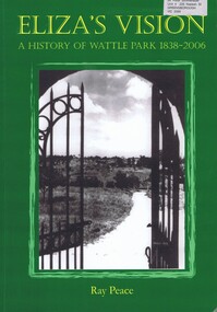 Greensborough Historical Society
Book, Ray Pearce, Eliza's vision: a history of Wattle Park 1838-2006, 2006
... of Victoria by Eliza Welch, as an open space. 76 years later... to the people of Victoria by Eliza Welch, as an open space. 76 years ...An outline of the history of Wattle Park (Vic).207 p., illus., colour map.non-fictionAn outline of the history of Wattle Park (Vic).urban parks - melbourne, wattle park (vic.), parks - melbourne - history -
 Kew Historical Society Inc
Photograph - Yarra Flats near Burke Road Bridge, 1937
... open space, parkland or public golf links. By the 1930s much... along the Yarra River in Kew is now either designated open space ...Land along the Yarra River in Kew is now either designated open space, parkland or public golf links. By the 1930s much of this area remained open farmland, bought at auction for dairy farming in the 1840s.Original, black and white positive print of what is said to be the Yarra Flats near Burke Road Bridge. On the horizon, building can be seen, whereas in the middle ground, farm fencing and a windmill are the main features as well as remnant Eucalypts. Inscribed verso: "Yarra Flats near Burke Rd Bridge 1937" studley park -- kew (vic.) -
![Newspaper Clipping - Digital Image, 2000 [pounds] for public open space 1965, 05/11/1965](/media/collectors/4f729f5697f83e03086015b8/items/5eb3933621ea670b94e21892/item-media/5eb3938a21ea670b94e2e147/item-fit-380x285.jpg) Greensborough Historical Society
Greensborough Historical SocietyNewspaper Clipping - Digital Image, 2000 [pounds] for public open space 1965, 05/11/1965
... 2000 [pounds] for public open space 1965... off Para Road zoned for public open space and offered the land... adjoining the Plenty River off Para Road zoned for public open space ...In 1965, the Board of Works advised Eltham Council that it had purchased 1 1/2 acres of land adjoining the Plenty River off Para Road zoned for public open space and offered the land to Council.An example of developments in the Greensborough area during the 1960sNews clipping, black and white text.shire of diamond valley, para road greensborough, melbourne and metropolitan board of works, plenty river, shire of eltham -
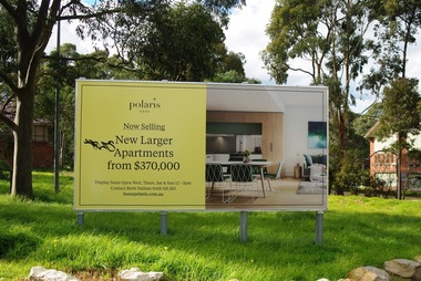 Greensborough Historical Society
Photograph - Digital Image, Marilyn Smith, Polaris sign at Larundel, 05/09/2017
... the open space at Larundel for residential and commercial use..... The Polaris development has utilised the open space at Larundel ...This photograph shows the Polaris sign at the old Larundel Hospital site. Some buildings on this site are heritage listed on the Victorian Heritage Database. The Polaris development has utilised the open space at Larundel for residential and commercial use.Digital copy of colour photographlarundel hospital, polaris -
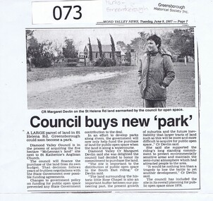 Greensborough Historical Society
Article - Newspaper Clipping, Diamond Valley Leader, Council buys new 'park', 09/06/1987
... land for public open space in the South East Riding of Diamond... land for public open space in the South East Riding of Diamond ...Diamond Valley Council honours a commitment to purchase land for public open space in the South East Riding of Diamond Valley in 1987. The land is in St Helena Road Greensborough adjacent to St Katherine's Anglican Church.This land abuts St Katherine's Church St Helena, originally built by Anthony Beale and named for his wife Katherine Rose. Newspaper article photocopied onto A4 page, 3 columns of text under black and white photograph of Cr Margaret Devlin at St Katherine's Church St Helena. 2 copies.Diamond Valley News Tuesday June 9, 1987 - page 7.anthony beale, st helena, st katherines church, parks greensborough, beale reserve -
 Federation University Historical Collection
Book, Ballarat Conservation Guidelines, 1981, 1981
... Wendouree, Public Open Spaces, Street Works, Fences and Landscaping... Wendouree, Public Open Spaces, Street Works, Fences and Landscaping ...The Guidelines were commissioned by the City of Ballarat , Historical Buildings Preservation Council and the Australian Heritage Commission.Cream soft coloured book of 60 pages. Contents include - Contributary Commercial Buildings, New COmmercial Buildings, Contributary residential Buildings, New Residential Development, Public and In stitutiona Buildings, Railways, Cemeteries, Botanic Gardens, Lake Wendouree, Public Open Spaces, Street Works, Fences and Landscaping, Advertising Guidelines, Lydiard/Camp Street Precinct Case Studyballarat, conservation guidelines, lydiard/camp street precinct case study, railway, botanic gardens, guttes, footpaths, signs, signage, fences, robin nuttall, gerald jenzen, ray tonkin, conservation study, architectural styles, verandahs, shopfronts, cast iron, wndy jacobs, miles lewis, gary vines, heritage planning, heritage guidelines -
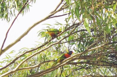 Greensborough Historical Society
Photograph - Digital Image, Marilyn Smith, Birds at Larundel, 05/09/2017
... development has utilised the open space at Larundel for residential.... The Polaris development has utilised the open space at Larundel ...This photograph shows some wildlife (birds) at the old Larundel Hospital site. Some buildings on this site are heritage listed on the Victorian Heritage Database. The Polaris development has utilised the open space at Larundel for residential and commercial use.Digital copy of colour photographlarundel hospital, polaris, birds