Showing 106 items matching "peninsular "
-
 Queenscliffe Maritime Museum
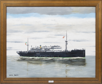
Painting - SS Romolo, Dacre Smyth
The Romolo was built by Lloyd Triestino Soc.Anon.di Nav., reg. Genoa and on 15 June 1940 she was sunk by H.M.A.S. MANOORA near Cape York peninsular after the crew set fire & abandoned the ship.An oil painting of the SS Romolo in a timber frame.Romoloss romolo, hmas manoora, wwii -
 The Beechworth Burke Museum
Audio - Oral History, Jennifer Williams, Mr Graeme Gallus, 16 November 2000
Graeme Gallus was born on the Mornington Peninsular in a town called Sommerville, in 1938. His family was born in Germany and came to Australia in 1851. He arrived in Beechworth in 1981 after purchasing a taxi service. He talks about local businesses, government employment, community celebrations and clubs. Miss Amy Elizabeth Porrit's account of her life in Beechworth and the local area during the 20th century is historically and socially significant to the cultural heritage of the region. She details important historical events and hardships in the region's history that had a lasting local, regional and national impact, including Australia during war time, economic struggles, and women's societal roles in a rural area. This oral history account is socially and historically significant as it is a part of a broader collection of interviews conducted by Jennifer Williams which were published in the book 'Listen to what they say: voices of twentieth-century Beechworth.' While the township of Beechworth is known for its history as a gold rush town, these accounts provide a unique insight into the day-to-day life of the town's residents during the 20th century, many of which will have now been lost if they had not been preserved.This is a digital copy of a recording that was originally captured on a cassette tape. The cassette tape is black with a horizontal white strip and is currently stored in a clear flat plastic rectangular container. It holds up 40 minutes of recordings on each side.Mr Graeme Gallussommerville, gallus, graeme gallus, taxi, beechworth, real estate, christmas, lions club -
 Mission to Seafarers Victoria
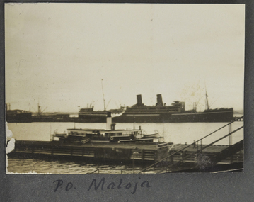
Photograph - Photograph, Sepia, P. O. Maloja, 1928
Named after another ship operating from 1911, RMS Maloja was a passenger liner of the Peninsular and Oriental Steam Navigation Company, operating between 1923 and 1954. In 1924: London/Colombo/Melbourne/Sydney service. During WWII the ship was requisitioned by the Admiralty for service as an Armed Merchant Cruiser.One of two photographs in the collection of a vessel named Maloja, which operated between London and Sydney via Ceylon (Sri Lanka as it later became).small landscape sepia photograph adhered to an album page. Depicts 2 vessels an ocean going 2 stack ship in the distance and a smaller vessel (ferry or coaster) moored against a pier.Hand-written on album page along lower edge in black ink: " PO Maloja"steam ships, world war 2, fan album, ships, piers, port melbourne -
 Waverley RSL Sub Branch
Photographic Print, W. H. Houghton 929 57Batallion
William (Bill) Houghton 929 enlisted 24 August 1914 and was taken on strength in the 57th Battalion Unit embarked from Melbourne, Victoria, on board Transport A3 Orvieto on 21 October 1914 and was sent to the Gallipoli Peninsular He later fought in France with the 5th Battalion H company. Was promoted to Lance Corporal and returned to Australia 12 March 1918Black and white printhoughton, william houghton, bill houghton, 57th battalion, gallipoli, a.n.z.a.c, a.i.f., anzac, w. houghton, w houghton -
 Mission to Seafarers Victoria
Print - Reproduction, Johnston, P&O 'Iberia' - 29,600 Tons, c.1960
SS Iberia was an ocean liner completed in 1954 for the Peninsular and Oriental Steam Navigation Company (P&O). Along withother liners, Iberia mainly provided passenger service between the United Kingdom and Australia. In the Annual Report 1954, Padre Oliver mentions: " Two fine new P & O ships made their maiden voyages during the year: "Arcadia" and "Iberia". In each case I was privileged to help to represent the Mission at the official luncheon."Marine artColour printed reproduction of a painting or lithograph print featuring 20th C passenger liner, hull and superstructure primarily painted white, under steam at sea. Small tug/fishing vessel in foreground. Larger steam ship on horizon. Print on plain board backing with plain mitred timber frame. Eyelet screws with wire.Printed signature lower right. 'JOHNSTON'iberia, passenger ship, p&o, marine painting, passenger ships, artwork-paintings, peninsular and oriental steam navigation company -
 City of Moorabbin Historical Society (Operating the Box Cottage Museum)
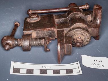
Tools, steel vice, c1900
Perak or State of Perak one of the 13 states of Malaysia, is the second largest state in Peninsular Malaysia. It borders Kedah and the Thai Yala Province to the north; Penang to the northwest; Kelantan and Pahang to the east; Selangor to the south, and the Straits of Malacca to the west. The state's administrative capital of Ipoh was known historically for tin-mining activities until the price of the metal dropped, severely affecting the state's economy. A vice is a tool with 2 jaws between which an object is gripped, usually by tightening a screw, so as to leave the hands free for working upon it. The vice is usually firmly attached to a bench . A steel vice THE PERAK TIN MINING COMPANYtools, vice, steel , clamps, metalwork, woodwork, carpentry, early settlers, pioneers, market gardeners, moorabbin, bentleigh, cheltenham, blacksmiths, perak tin mining co. -
 Montmorency–Eltham RSL Sub Branch
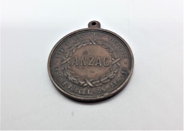
Medal - Medallion, ANZAC, Victorian Department of Education 1916, 1916
The ANZAC Day medallion was issued for sale in 1916. The medallion was struck by the Education Department of Victoria for school children in 1916, to commemorate the first anniversary of the ANZAC Forces landing at Gallipoli on 25 April 1915. An article in the ARGUS newspaper, written at the time, stated that the medallions were issued for sale for the price of sixpence. Although 175,000 medallions were made, this proved insufficient for demand. The medallion was sold to Victorian school children at commemorations of the landing of the of the Australian and New Zealand troops arriving on the Gallipoli Peninsular in 1915. The medallion was also distributed to the public on ANZAC Button Day for one shilling. Circular medal with an eyelet at the top for attaching loop holding ribbon (loop and ribbon missing). Obverse ... head of King George V facing left Reverse ... wreath surrounding inscription (see below) The edge of the medallion is plain. Obverse ... FOR KING AND COUNTRY 1916 Reverse ... ANZAC (surrounded by wreath) DEPT. OF EDUCATION VICTORIA LEST WE FORGET 25 APR 15 (around circumference)anzac day, commemoration, school children, ww2, 1916 anzac medallion -
 Bendigo Historical Society Inc.
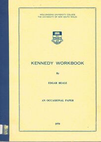
Book - ALEC H CHISHOLM COLLECTION: BOOK ''KENNEDY WORKBOOK'' BY EDGAR BEALE
Book. ALEC H CHISHOLM COLLECTION. Two copies of a 111 page soft cover book by Edgar Beale of an analysis of Edmund B Kennedy's exploration in 1848 of Cape York Peninsular with transcripts of parts of his journal. Published by Wollongong University College in 1970. Catalogue stickers ''2252.1 BEA'' and ''2252.2 BEA'' on spines. Handwritten notations in ink on the flyleaf of each copy as follows - Copy 93a ''Alec H Chisholm Esq. In gratitude for many favours. This is an entirely unreadable companion to my Life of Kennedy which should appear any time now. Kindest regards, Edgar Beale.'' Copy 93b ''For Alec Chisholm, with gratitude and a friendly warning - don't even try to read this ! From the author, Edgar Beale''Edgar Bealebooks, collections, history, alec h chisholm collection, edmund b kennedy, exploration, edgar beale -
 Wangaratta RSL Sub Branch
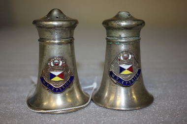
Souvenir - Silver metal salt and pepper shakers with decorative emblem attached, Unknown
MV ETTRICK was a British Passenger Motor Vessel of 11,279 tons built in 1938 by Barclay Curle & Company, Glasgow, for the Peninsular & Oriental Steam Navigation Company. The Vessel was on charter to the Admiralty as a Troopship. On the 15th November 1942 she was torpedoed by German submarine U-155 at 0315, 150 miles W of Gibraltar. She sank at 0836. She was on a voyage from Gibraltar to the Clyde in ballast, with a crew of 204, 66 naval ratings, and 41 gunners. 18 naval ratings and 5 Asian crew were lost; another Asian seaman died of his injuries. Survivors were taken to Gibraltar by the Norwegian destroyer Glaisdal and returned to the UK in P&O´s Mooltan the following day.White metal salt and pepper shakers with an emblem attachedSalt and pepper shakers with embossing showing Flag and M.V. ETTRICK.mv ettrick, ww2, troopship -
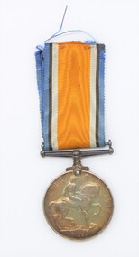
Woodend RSL
Medal - WW1 Victory Medal, 1919
Medal was posthumisously awarded to Pte NashRound Medal 36 mm Ribbon 38 mm Brass2200 PTE F N DASH 1 BN AIF (Frank Noel). KIA 6 August 1915 at Gallipoli. Frank Dash was born in Burwood, Sydney. He joined the Army 11/6/15 and was posted to the Gallipoli Peninsular, noteably Lone Pine, 6th August 1915. He was wounded by machine gun fire (neck and shoulder) 7/8/1915. He was transferred maybe to a hospital in Lemnos, but a subsequent Court of Enquiry determined he was KIA. His father's address was Ballarat when plaque and scroll were delivered. -
 Woodend RSL
Medal - 1914-1918 WW1 medal, 1919
This medal was awarded, posthumously to Pte. Dash. He was born in Burwood(a small town near Sydney). He joined the Army 12/6/1915. Strangely, he did his medical inspection in May. He is listed as being in 1st Battalion from 18 May until 5 August. 6th August he arrived at the Battalion (on the Gallipoli Peninsular). He was wounded 7 August, whilst delivering ammunition, by machine gun with wounds to the neck and shoulder. From there, there was no record of him and was catergorised as Missing in Action". His father received notification with scroll 21/12/21. He received his Victory Medal Jan 18 1923. Pte Dash is interred in the Lone Pine cemetery, in Turkey. He was originally interred in Brown's Dip cemetery, but this site was deemed unsuitable for cemetery due to the changing landscape due to flood waters. Pte Dash was discovered in Lemnos, convalesencing after being hospitalised, 1st October 1915. However the board of inquiry made no mention of his sighting in Lemnos. He was interred in Gallipoli, so the sighting in Lemnos appears to be a mistake.British World War 1 Medal issued to Australians Round 36 mm Ribbon Royal Blue/Black/White/16 mm orange/White/Black/Royal Blue The Observse side is a bust of the King (George V). The reverse is a horseman astride his steed.2220 PTE F N DASH 1 BN AIF -
 Ballarat Clarendon College
Albert Telfer White (1918) collection
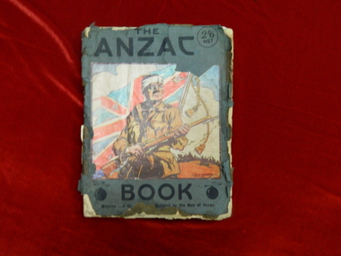
Significant items relating to Albert Telfer White who entered Ballarat College April 1912 and left December 1918. Albert was born 29 June 1897 at his home 'Ashford Vale" farm, Cuthbert's Road, Cardigan. Albert, a second generation Australian, was the fourth son and sixth of eleven children born to dairy farmer John White and his wife Elizabeth, nee Douglas. Albert attended Bunker's Hill State School prior to enrolling at Ballarat College. After College he obtained employment with the engineering firm Ronaldson and Tippett in Ballarat. Following his eighteenth birthday Albert enlisted in the AIF in Ballarat with the rank of Private, No 2012. He embarked for the Middle East with 23rd Battalion on 26 August 1915 and was 'taken on strength at the Gallipoli Peninsular 25 October 1915". On 10 January 1916 Albert was posted to Alexandria, Egypt and during this time he was able to meet with his aunt Rose Douglas, an Australian Army Nursing Sister. This was a great comfort to his family. Albert was sent to France 19 March 1916 and transferred to the 22nd Battalion. He was mentioned in dispatches for 'good and gallant conduct' 5 August (1917?). Albert was hospitalised 30 March 1918, rejoined 22nd Battalion 3 June 1918, wounded in action 3 October 1918 but died of wounds at Rouen 10 October 1918. news of his death was received by his family n Australia just prior to the armistice. Albert Telfer White's sacrifice is commemorated at Ballarat College, Avenue of Honour Ballarat (Tree 1214), Ballarat Shire Honour Avenue Learmonth (Tree 163) and the Australian War Memorial Canberra. (These notes provided by family November 2016)Collections of items including: Bayonet, Carl Eickhorn, Solingen, (29.A.159 engraved on handle) Trench shovel The ANZAC book 1916 (flyleaf inscribed: No 2012 / Pte A T White / H Quarters / 22nd Battalion / 6th Inf Brigade / France) Gallipoli medal with documentation First World War Mothers’ and Widows’ Badge Next of Kin Memorial Plaque (Death Penny) and accompanying letter from King George V Imperial War Graves Commission documentation and photograph Australia Graves Services In Memory card and photograph Documentation relating to Australian War Memorial Roll of Honour, Learmonth Memorial Wall, Ballarat and Learmonth Avenues of Honours Documentation from the Australian Army Records office Documentation relating to Military Medal, 1914/15 Star, British War Medal and Victory Medal (whereabouts unknown, November 2016) Portraiture of Albert Telfer White as a child, as a young adult (civilian dress), in full kit (A I E F formal), and at camp 1915 Portraiture of sisters Cis, Addie, Bessie, Evelyn (with personal inscriptions) Four postcards (one with letter from Albert ‘at sea’ to his mother - undated) Death notice (unreferenced newspaper clipping) Biographical and family relationship details Photocopy of The White Family 1906 showing (standing) Adeline, Leslie, Harold (father), Muriel (mother), William; (seated) Albert, John (Grandfather), Elizabeth, Allan, Elizabeth (Grandmother), Evelyn (baby) and Benjamin The ANZAC book 1916 (flyleaf inscribed: No 2012 / Pte A T White / H Quarters / 22nd Battalion / 6th Inf Brigade / France) Gallipoli medal: engraved on reverse: A T WHITE Embossed lettering on death penny: ALBERT TELFER WHITE Handwritten on reverse of portraits: Lovingly yours / Cis / 21/11/17; your / loving sister / Addie; your loving / sister / Evelyn; Yours lovingly / Bessie Handwritten on back of postcard of ship H M A T 'Anchisis' 14.3.16: Dear Mother, I am sending you a card / of the boat we are on. Our deck is right / on the back. I have marked it with an X. / We are not allowed to put the date on or / where we are. I am sitting on the deck now / holding the card in my hand so it is hard / to write. We are together yet haven't been / separated Bill, Matt and myself. Haven't / had anything to do. I will write a couple / of letters now. Albert Handwritten on back of postcard photograph of Albert at camp: 30th September 1915 / Dear Mother / There is a studio at the / camp so Matt and I got our Photos / taken yesterday morning, & got them/ this morning. I am sending / Ciss one of Matt.albert-telfer-white, ballarat college, world-war-one, avenue-of-honour -
 Ballarat Clarendon College
Medal, 1914-15 Star
The 1914–15 Star was authorised in 1918 and was awarded for service in specified theatres of war between 5 August 1914 and 31 December 1915. A recipient of the 1914 Star could not also be awarded the 1914–15 Star. Albert was born 29 June 1897 at his home 'Ashford Vale" farm, Cuthbert's Road, Cardigan. Albert, a second generation Australian, was the fourth son and sixth of eleven children born to dairy farmer John White and his wife Elizabeth, nee Douglas. Albert attended Bunker's Hill State School prior to enrolling at Ballarat College. After College he obtained employment with the engineering firm Ronaldson and Tippett in Ballarat. Following his eighteenth birthday Albert enlisted in the AIF in Ballarat with the rank of Private, No 2012. He embarked for the Middle East with 23rd Battalion on 26 August 1915 and was 'taken on strength at the Gallipoli Peninsular 25 October 1915". On 10 January 1916 Albert was posted to Alexandria, Egypt and during this time he was able to meet with his aunt Rose Douglas, an Australian Army Nursing Sister. This was a great comfort to his family. Albert was sent to France 19 March 1916 and transferred to the 22nd Battalion. He was mentioned in dispatches for 'good and gallant conduct' 5 August (1917?). Albert was hospitalised 30 March 1918, rejoined 22nd Battalion 3 June 1918, wounded in action 3 October 1918 but died of wounds at Rouen 10 October 1918. news of his death was received by his family in Australia just prior to the armistice. Albert Telfer White's sacrifice is commemorated at Ballarat College, Avenue of Honour Ballarat (Tree 1214), Ballarat Shire Honour Avenue Learmonth (Tree 163) and the Australian War Memorial Canberra. (These notes provided by family November 2016)Part of a greater A T White CollectionThe 1914-15 Star is a four pointed star of bright bronze, ensigned with a crown. The obverse has crossed gladius, overlaid with an oak wreath that is ensigned with the cypher of King George V. A scroll bearing the legend 1914-15 is centrally placed across the crossed blades. The 1914-15 Star ribbon has the red white and blue colours of the Empire, in shaded and watered stripes.Engraved on a scroll in the centre of the medal front: '1914-15' The oak wreath is ensigned with the cypher of King George V. The back of the medal is engraved: 2012 / Pte A T White / 23/BN. A.I.F. albert-telfer-white, medal, world war one, 1914-15 star -
 Eltham District Historical Society Inc
Photograph, Upper Yarra Dam, Spring Tour, 22 Oct 1995, 22/10/1995
EXPLORING THE UPPER YARRA (Newsletter No. 105, November 1995, by Bettina Woodburn) We enjoyed the Spring Excursion, this year "Exploring the Upper Yarra" - in spite of the constant rain and the countryside under the cloud cover, especially in the valleys, being mainly shiny shades of green. The occasional fields of buttercups, clumps of arum lilies and splendid rhododendron and other flowering bushes became very special. The Cobb and Co coach was warm and a cosy retreat as we zig-zagged on the highways and byways to glimpse the Yarra River, upstream and down, its secret places, and particularly the many bridges. Russell excelled as 'Poet Laureate', reading from Dacre Smyth's book. This 1979 publication includes paintings of all the bridges along the river with poems and brief descriptions of each one. Some of the bridges are in out of the way places and are not very well known. We looked forward to hearing the poetry as much as seeing the ' constructions'…Big Pat (was he short or tall, lean or fat? He did win the two hundred pound reward for discovering gold and had the creek named after him), about the 'Eddies'?, and the disliked 'meccano' bridge in Warburton, etc. etc. The hot roast lunch in the old Reefton Hotel was also most welcome. It was easy to imagine it peopled by miners and early settlers. Starting by crossing the new (1974) concrete bridge at Warrandyte we headed through Wonga Park with views to the Christmas Hills and to the escarpment of the Yering Gorge, which causes flood waters to back up through the Yarra Glen plain, so avoiding disasters downstream. At the end of a long driveway we found the wooden, privately owned Henley Bridge (1935 after the 1934 floods). This facilitates access to different parts of Henley Farm and to Lilydale. Everard Park, named after Blanche Shallard's father, a State Member for 17 years, below the Highway Yarra crossing was in need of care. It is 10 miles from Yarra Glen by road but, as "Yarra Marra” canoeists well know, 32 winding miles down by water. After more delightful countryside scenes we joined the Warburton Highway at Woori Yallock. From the old Railway Station at Launching Place the Centennial Trail for walkers, cyclists and ' horse riders has replaced the rails. The line from Lilydale was opened in 1901, and the last diesel freight train ran to Warburton in 1965. It continued to rain as we had morning tea in Warburton in a shelter between footbridges. From here we continued upstream past the Bridge to O'Shannasy Lodge and Reservoir, Starvation Creek, and the Peninsular tunnel (miners dug it as at Pound Bend) which we visited (scrambling down those steps!) on our return after lunch. Our furthermost point was the Upper Yarra Dam Reserve (and vast catchment area). Finished in 1957 after ten years work and 100 years after Yan Yean, it supplies much of Melbourne's water. After crossing the 30m Launching Place Bridge to the Eltham side of the Yarra and Healesville, we saw in the distance the Yarra Glen Timber Trestle Bridge over the river flats "the longest for years in the land it was said!" Harry's dream of "better weather over the Divide" unfortunately didn't come true, but I'm sure we 36 members will retain happy memories of a day that was wet and green and filled with Bridges. Bettina Woodburn - October 1995 Record of the Society's history of activities - Spring 1995 excursionColour photographshire of eltham historical society, activities, upper yarra dam, henley bridge -
 Eltham District Historical Society Inc
Photograph, Upper Yarra Dam, Spring Tour, 22 Oct 1995, 22/10/1995
EXPLORING THE UPPER YARRA (Newsletter No. 105, November 1995, by Bettina Woodburn) We enjoyed the Spring Excursion, this year "Exploring the Upper Yarra" - in spite of the constant rain and the countryside under the cloud cover, especially in the valleys, being mainly shiny shades of green. The occasional fields of buttercups, clumps of arum lilies and splendid rhododendron and other flowering bushes became very special. The Cobb and Co coach was warm and a cosy retreat as we zig-zagged on the highways and byways to glimpse the Yarra River, upstream and down, its secret places, and particularly the many bridges. Russell excelled as 'Poet Laureate', reading from Dacre Smyth's book. This 1979 publication includes paintings of all the bridges along the river with poems and brief descriptions of each one. Some of the bridges are in out of the way places and are not very well known. We looked forward to hearing the poetry as much as seeing the ' constructions'…Big Pat (was he short or tall, lean or fat? He did win the two hundred pound reward for discovering gold and had the creek named after him), about the 'Eddies'?, and the disliked 'meccano' bridge in Warburton, etc. etc. The hot roast lunch in the old Reefton Hotel was also most welcome. It was easy to imagine it peopled by miners and early settlers. Starting by crossing the new (1974) concrete bridge at Warrandyte we headed through Wonga Park with views to the Christmas Hills and to the escarpment of the Yering Gorge, which causes flood waters to back up through the Yarra Glen plain, so avoiding disasters downstream. At the end of a long driveway we found the wooden, privately owned Henley Bridge (1935 after the 1934 floods). This facilitates access to different parts of Henley Farm and to Lilydale. Everard Park, named after Blanche Shallard's father, a State Member for 17 years, below the Highway Yarra crossing was in need of care. It is 10 miles from Yarra Glen by road but, as "Yarra Marra” canoeists well know, 32 winding miles down by water. After more delightful countryside scenes we joined the Warburton Highway at Woori Yallock. From the old Railway Station at Launching Place the Centennial Trail for walkers, cyclists and ' horse riders has replaced the rails. The line from Lilydale was opened in 1901, and the last diesel freight train ran to Warburton in 1965. It continued to rain as we had morning tea in Warburton in a shelter between footbridges. From here we continued upstream past the Bridge to O'Shannasy Lodge and Reservoir, Starvation Creek, and the Peninsular tunnel (miners dug it as at Pound Bend) which we visited (scrambling down those steps!) on our return after lunch. Our furthermost point was the Upper Yarra Dam Reserve (and vast catchment area). Finished in 1957 after ten years work and 100 years after Yan Yean, it supplies much of Melbourne's water. After crossing the 30m Launching Place Bridge to the Eltham side of the Yarra and Healesville, we saw in the distance the Yarra Glen Timber Trestle Bridge over the river flats "the longest for years in the land it was said!" Harry's dream of "better weather over the Divide" unfortunately didn't come true, but I'm sure we 36 members will retain happy memories of a day that was wet and green and filled with Bridges. Bettina Woodburn - October 1995 Record of the Society's history of activities - Spring 1995 excursionRoll of 35mm colour negative film, 3 stripsKodak Gold 200-4shire of eltham historical society, activities, upper yarra dam, henley bridge -
 Eltham District Historical Society Inc
Photograph, Upper Yarra Dam, Spring Tour, 22 Oct 1995, 22/10/1995
EXPLORING THE UPPER YARRA (Newsletter No. 105, November 1995, by Bettina Woodburn) We enjoyed the Spring Excursion, this year "Exploring the Upper Yarra" - in spite of the constant rain and the countryside under the cloud cover, especially in the valleys, being mainly shiny shades of green. The occasional fields of buttercups, clumps of arum lilies and splendid rhododendron and other flowering bushes became very special. The Cobb and Co coach was warm and a cosy retreat as we zig-zagged on the highways and byways to glimpse the Yarra River, upstream and down, its secret places, and particularly the many bridges. Russell excelled as 'Poet Laureate', reading from Dacre Smyth's book. This 1979 publication includes paintings of all the bridges along the river with poems and brief descriptions of each one. Some of the bridges are in out of the way places and are not very well known. We looked forward to hearing the poetry as much as seeing the ' constructions'…Big Pat (was he short or tall, lean or fat? He did win the two hundred pound reward for discovering gold and had the creek named after him), about the 'Eddies'?, and the disliked 'meccano' bridge in Warburton, etc. etc. The hot roast lunch in the old Reefton Hotel was also most welcome. It was easy to imagine it peopled by miners and early settlers. Starting by crossing the new (1974) concrete bridge at Warrandyte we headed through Wonga Park with views to the Christmas Hills and to the escarpment of the Yering Gorge, which causes flood waters to back up through the Yarra Glen plain, so avoiding disasters downstream. At the end of a long driveway we found the wooden, privately owned Henley Bridge (1935 after the 1934 floods). This facilitates access to different parts of Henley Farm and to Lilydale. Everard Park, named after Blanche Shallard's father, a State Member for 17 years, below the Highway Yarra crossing was in need of care. It is 10 miles from Yarra Glen by road but, as "Yarra Marra” canoeists well know, 32 winding miles down by water. After more delightful countryside scenes we joined the Warburton Highway at Woori Yallock. From the old Railway Station at Launching Place the Centennial Trail for walkers, cyclists and ' horse riders has replaced the rails. The line from Lilydale was opened in 1901, and the last diesel freight train ran to Warburton in 1965. It continued to rain as we had morning tea in Warburton in a shelter between footbridges. From here we continued upstream past the Bridge to O'Shannasy Lodge and Reservoir, Starvation Creek, and the Peninsular tunnel (miners dug it as at Pound Bend) which we visited (scrambling down those steps!) on our return after lunch. Our furthermost point was the Upper Yarra Dam Reserve (and vast catchment area). Finished in 1957 after ten years work and 100 years after Yan Yean, it supplies much of Melbourne's water. After crossing the 30m Launching Place Bridge to the Eltham side of the Yarra and Healesville, we saw in the distance the Yarra Glen Timber Trestle Bridge over the river flats "the longest for years in the land it was said!" Harry's dream of "better weather over the Divide" unfortunately didn't come true, but I'm sure we 36 members will retain happy memories of a day that was wet and green and filled with Bridges. Bettina Woodburn - October 1995 Record of the Society's history of activities - Spring 1995 excursionRoll of 35mm colour negative film, 2 stripsKodak Gold 100-4shire of eltham historical society, activities, upper yarra dam, henley bridge -
 Eltham District Historical Society Inc
Photograph, Upper Yarra Dam, Spring Tour, 22 Oct 1995, 22/10/1995
EXPLORING THE UPPER YARRA (Newsletter No. 105, November 1995, by Bettina Woodburn) We enjoyed the Spring Excursion, this year "Exploring the Upper Yarra" - in spite of the constant rain and the countryside under the cloud cover, especially in the valleys, being mainly shiny shades of green. The occasional fields of buttercups, clumps of arum lilies and splendid rhododendron and other flowering bushes became very special. The Cobb and Co coach was warm and a cosy retreat as we zig-zagged on the highways and byways to glimpse the Yarra River, upstream and down, its secret places, and particularly the many bridges. Russell excelled as 'Poet Laureate', reading from Dacre Smyth's book. This 1979 publication includes paintings of all the bridges along the river with poems and brief descriptions of each one. Some of the bridges are in out of the way places and are not very well known. We looked forward to hearing the poetry as much as seeing the ' constructions'…Big Pat (was he short or tall, lean or fat? He did win the two hundred pound reward for discovering gold and had the creek named after him), about the 'Eddies'?, and the disliked 'meccano' bridge in Warburton, etc. etc. The hot roast lunch in the old Reefton Hotel was also most welcome. It was easy to imagine it peopled by miners and early settlers. Starting by crossing the new (1974) concrete bridge at Warrandyte we headed through Wonga Park with views to the Christmas Hills and to the escarpment of the Yering Gorge, which causes flood waters to back up through the Yarra Glen plain, so avoiding disasters downstream. At the end of a long driveway we found the wooden, privately owned Henley Bridge (1935 after the 1934 floods). This facilitates access to different parts of Henley Farm and to Lilydale. Everard Park, named after Blanche Shallard's father, a State Member for 17 years, below the Highway Yarra crossing was in need of care. It is 10 miles from Yarra Glen by road but, as "Yarra Marra” canoeists well know, 32 winding miles down by water. After more delightful countryside scenes we joined the Warburton Highway at Woori Yallock. From the old Railway Station at Launching Place the Centennial Trail for walkers, cyclists and ' horse riders has replaced the rails. The line from Lilydale was opened in 1901, and the last diesel freight train ran to Warburton in 1965. It continued to rain as we had morning tea in Warburton in a shelter between footbridges. From here we continued upstream past the Bridge to O'Shannasy Lodge and Reservoir, Starvation Creek, and the Peninsular tunnel (miners dug it as at Pound Bend) which we visited (scrambling down those steps!) on our return after lunch. Our furthermost point was the Upper Yarra Dam Reserve (and vast catchment area). Finished in 1957 after ten years work and 100 years after Yan Yean, it supplies much of Melbourne's water. After crossing the 30m Launching Place Bridge to the Eltham side of the Yarra and Healesville, we saw in the distance the Yarra Glen Timber Trestle Bridge over the river flats "the longest for years in the land it was said!" Harry's dream of "better weather over the Divide" unfortunately didn't come true, but I'm sure we 36 members will retain happy memories of a day that was wet and green and filled with Bridges. Bettina Woodburn - October 1995 Record of the Society's history of activities - Spring 1995 excursionRoll of 35mm colour negative film, 4 of 5 stripsKodak Gold 400-5shire of eltham historical society, activities, upper yarra dam, henley bridge -
 Eltham District Historical Society Inc
Photograph, Upper Yarra Dam, Spring Tour, 22 Oct 1995, 22/10/1995
EXPLORING THE UPPER YARRA (Newsletter No. 105, November 1995, by Bettina Woodburn) We enjoyed the Spring Excursion, this year "Exploring the Upper Yarra" - in spite of the constant rain and the countryside under the cloud cover, especially in the valleys, being mainly shiny shades of green. The occasional fields of buttercups, clumps of arum lilies and splendid rhododendron and other flowering bushes became very special. The Cobb and Co coach was warm and a cosy retreat as we zig-zagged on the highways and byways to glimpse the Yarra River, upstream and down, its secret places, and particularly the many bridges. Russell excelled as 'Poet Laureate', reading from Dacre Smyth's book. This 1979 publication includes paintings of all the bridges along the river with poems and brief descriptions of each one. Some of the bridges are in out of the way places and are not very well known. We looked forward to hearing the poetry as much as seeing the ' constructions'…Big Pat (was he short or tall, lean or fat? He did win the two hundred pound reward for discovering gold and had the creek named after him), about the 'Eddies'?, and the disliked 'meccano' bridge in Warburton, etc. etc. The hot roast lunch in the old Reefton Hotel was also most welcome. It was easy to imagine it peopled by miners and early settlers. Starting by crossing the new (1974) concrete bridge at Warrandyte we headed through Wonga Park with views to the Christmas Hills and to the escarpment of the Yering Gorge, which causes flood waters to back up through the Yarra Glen plain, so avoiding disasters downstream. At the end of a long driveway we found the wooden, privately owned Henley Bridge (1935 after the 1934 floods). This facilitates access to different parts of Henley Farm and to Lilydale. Everard Park, named after Blanche Shallard's father, a State Member for 17 years, below the Highway Yarra crossing was in need of care. It is 10 miles from Yarra Glen by road but, as "Yarra Marra” canoeists well know, 32 winding miles down by water. After more delightful countryside scenes we joined the Warburton Highway at Woori Yallock. From the old Railway Station at Launching Place the Centennial Trail for walkers, cyclists and ' horse riders has replaced the rails. The line from Lilydale was opened in 1901, and the last diesel freight train ran to Warburton in 1965. It continued to rain as we had morning tea in Warburton in a shelter between footbridges. From here we continued upstream past the Bridge to O'Shannasy Lodge and Reservoir, Starvation Creek, and the Peninsular tunnel (miners dug it as at Pound Bend) which we visited (scrambling down those steps!) on our return after lunch. Our furthermost point was the Upper Yarra Dam Reserve (and vast catchment area). Finished in 1957 after ten years work and 100 years after Yan Yean, it supplies much of Melbourne's water. After crossing the 30m Launching Place Bridge to the Eltham side of the Yarra and Healesville, we saw in the distance the Yarra Glen Timber Trestle Bridge over the river flats "the longest for years in the land it was said!" Harry's dream of "better weather over the Divide" unfortunately didn't come true, but I'm sure we 36 members will retain happy memories of a day that was wet and green and filled with Bridges. Bettina Woodburn - October 1995 Record of the Society's history of activities - Spring 1995 excursionRoll of 35mm colour negative film, 4 of 5 stripsKodak Gold 400-5shire of eltham historical society, activities, upper yarra dam, henley bridge