Showing 64 items matching "point grant"
-
 Glenelg Shire Council Cultural Collection
Photograph - Photograph - Quarry, Cape Grant, n.d
Port of Portland Authority Archivesport of portland archives -
 Flagstaff Hill Maritime Museum and Village
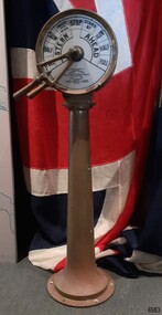
Equipment - Ship's Telegraph section, Chadburn & Sons, 1875-1898
This is the Bridge Section of a ship’s telegraph and is a Duplex Gong model, made by Chadburn & Son of Liverpool. This duplex gong model would sound two signals whenever the navigational commands were given by the ship’s pilot to change the speed or direction. The ship’s telegraph was installed on Flagstaff Hill’s exhibit of the 1909 Hobart, Tasmania, ferry “SS Rowitta” installed in 1975 and enjoyed for more than 40 years. Communication between the ship’s pilot and the engine room in the late 19th century to the mid-20th-century was made with a system called an Engine Order Telegraph (E.O.T.) or ship’s telegraph. The equipment has two parts, the Bridge Section and the Engine Room Section. The Bridge Section is usually mounted onto a pedestal, and the Engine Room Section is attached to a vertical surface. The standard marine commands are printed or stamped around the face of the dial and indicated by a pointer or arrow that is usually moved by a rotating brass section or handle. The ship’s pilot stationed on the Bridge of a vessel sends his Orders for speed and direction to the Engine Room with the E.O.T. He moves the lever or levers, depending on the number of engines the ship has, to change the indicator on the Bridge Section’s dial to point in the new direction and speed of travel. This change causes the Orders to be duplicated on the Engine Room Section’s dial and a bell or bells to signal the change at the same time. The engineer then adjusts the ship’s engines and steering equipment to follow the pilot’s Order. CHADBURN & SON, Liverpool- Chadburn Brothers, William and C.H., were joint inventors and well-established makers of optical and scientific instruments and marine gauges. The firm was granted the Prince Albert Royal Warrant in the late 19th century. In 1870 William Chadburn applied for a patent for his navigational communication device for use on ships. By 1875 Chadburn & Son was producing the brass Engine Order Telegraph in its plant at 71 Lord Street, Liverpool. In 1911 the ship RMS Titanic was launched, fitted with Chadburn & Sons E.O.T. The Chadburn Ship Telegraph Company Limited was registered in 1898 to take over Chadburn & Sons. In 1903 a large factory at Bootle, near Liverpool, and their products were being sold overseas. In 1920 electric-powered telegraphs were developed. In 1944 the name changed to Chadburn’s (Liverpool) Limited. In 1968 the company became Chadburn Bloctube Ltd. In 2000 the company, now Bloctube Marine Limited, was still manufacturing ship telegraphs. SS ROWITTA: - The 1909 steam ferry, SS Rowitta, was installed as an exhibit at Flagstaff Hill in 1975 and was enjoyed by many visitors for 40 years. Rowitta was a timber steam ferry built in Hobart in 1909 using planks of Huon and Karri wood. It was a favourite of sightseeing passengers along Tasmania’s Tamar and Derwent rivers for 30 years. Rowitta was also known as Tarkarri and Sorrento and had worked as a coastal trading vessel between Devonport and Melbourne, and Melbourne Queenscliff and Sorrento. In 1974 Rowitta was purchased by Flagstaff Hilt to convert into a representation of the Speculant, a historic and locally significant sailing ship listed on the Victorian Heritage Database. (The Speculant was built in Scotland in 1895 and traded timber between the United Kingdom and Russia. Warrnambool’s P J McGennan & Co. then bought the vessel to trade pine timber from New Zealand to Victorian ports and cargo to Melbourne. It was the largest ship registered with Warrnambool as her home port, playing a key role in the early 1900s in the Port of Warrnambool. In 1911, on her way to Melbourne, it was wrecked near Cape Otway. None of the nine crew lost their lives.) The promised funds for converting Rowitta into the Speculant were no longer available, so it was restored back to its original configuration. The vessel represented the importance of coastal traders to transport, trade and communication in Australia times before rail and motor vehicles. Sadly, in 2015 the time had come to demolish the Rowitta due to her excessive deterioration and the high cost of ongoing repairs. The vessel had given over 100 years of service and pleasure to those who knew her. This Bridge section of a ship’s Engine Order Telegraph, used with an Engine Room section, represents late-19th century change and progress in communication and navigation at sea. This type of equipment was still in use in the mid-20th century. The object is significant for its association with its maker, Chadburn & Son, of Liverpool, a well-known marine instrument maker whose work was recognised by English Royalty, and whose products were selected to supply similar equipment for use on the RMS Titanic. This ship’s telegraph is connected to the history of the Rowitta, which was a large exhibit on display at Flagstaff Hill Maritime Village from the museum’s early beginnings until the vessel’s end of life 40 years later. The display was used as an aid to maritime education. The Rowitta represents the importance of coastal traders to transport, trade and communication along the coast of Victoria, between states, and in Australia before rail and motor vehicles. The vessel was an example of a ferry built in the early 20th century that served many different roles over its lifetime of over 100 years. Bridge section of a Ship’s Telegraph or Engine Order Telegraph (E.O.T.). The round double-sided, painted glass dial is contained within a brass case behind glass. It is fitted onto an outward tapering brass pedestal with a round base. The brass indicator arrows between the handles point simultaneously to both sides of the dial when moved. An oval brass maker’s plate is attached to the top of the case. The dial’s faces have inscriptions that indicate speed and direction, and the front face and plate include the maker’s details. A serial number is stamped on the collar where the dial is fitted to the pedestal. The ship’s telegraph is a Duplex Gong model, made by Chadburn & Son of Liverpool. Dial, maker’s details: “PATENT “DUPLEX GONG” TELEGRAPH / CHADBURN & SON / TELEGRAPH WORKS / PATENTEES & MANUFACTURERS / 11 WATERLOO ROAD / LIVERPOOL” LONDON / 105 FENCHURCH STREET” “NEWCASTLE / 85 QUAY + SIDE” “GLASGOW / 69 ANDERSON QUAY” “PATENT” Dial instructions: “FULL / HALF/ SLOW / FINISHED WITH ENGINES / STOP STAND BY / SLOW / HALF / FULL / ASTERN / AHEAD” Maker’s plate: “CHADBURN / & SON / PATENT / LIVERPOOL” Serial number: “22073”flagstaff hill, warrnambool, maritime village, maritime museum, shipwreck coast, great ocean road, engine order telegraph, e.o.t., navigational instrument, communication device, ship’s telegraph, engine room section, bridge section, rms titanic, chadburn & son, chadburn brothers, william chadburn, chadburn ship telegraph company, chadburns, duplex gong, liverpool, ss rowitta, navigation, marine technology, pilot’s orders, steam power, hobart, tasmania, devonport, tasmanian-built, ferry, steam ferry, steamer, 1909, early 20th century vessel, passenger vessel, tamar trading company, launceston, george town, sorrento, tarkarri, speculant, peter mcgennan, p j mcgennan & co. port phillip ferries pty ltd, melbourne, coastal trader, timber steamer, huon, karri, freighter, supply ship, charter ferry, floating restaurant, prawn boat, lakes entrance -
 Bendigo Historical Society Inc.
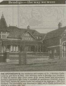
Newspaper - JENNY FOLEY COLLECTION: THE APOTHECARY
Bendigo Advertiser ''The way we were'' from 2000. The Apothecary's: the residence and surgery of Dr. J. McIntyre Eadie. Lured by gold fever in 1852, John McIntyre came to Bendigo from Scotland. In 1855 he married Jean Grant (sister of Dr. James Eadie) and immediately formed a partnership with Eadie to establish an apothecary (chemist) shop at View Point, Sandhurst. James Eadie had arrived at the diggings in 1854 from Scotland. The partnership was dissolved in 1869, yet Dr. Eadie continued his work as a surgeon until 1897. The clip is in a folder.newspaper, bendigo advertiser, the way we were -
 Bendigo Historical Society Inc.
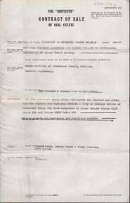
Document - H. A. & S. R. WILKINSON COLLECTION: CONTRACT OF SALE
Contract of sale of real estate dated 3rd December, 1964 between National Trustees Executors and Agency Company of Australasia as administrator of H. W. Bowden deceased (vendor) and Mr. C. Sartori (purchaser). Solicitor for vendor: Watson, James & Rogers, RACV Bldg. View Point, Bendigo. Solicitor for purchaser: Mr. H. E. Every, Dispensary Walk, Bendigo. Vacant land corner Grant & Priam Streets, Long Gully being Crown allotment 260 and 261 section A land comprised in Crown Grants volume 2195 folio 556 and volume 2190 folio 885. Price 225 pounds.organization, business, h.a. & s.r wilkinson real estate -
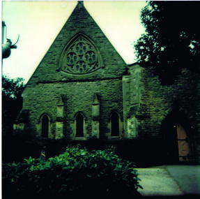
 St Kilda Historical Society
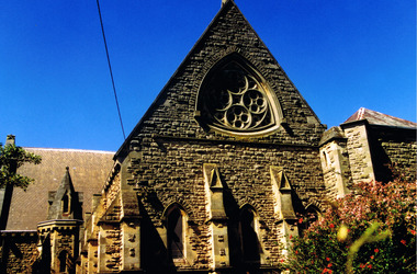
Photograph, Christ Church St Kilda exterior - images collection #1
Christ Church was constructed in 1854-57 and designed in Decorated Gothic style by Albert Purchase & Charles Swyer. It was enlarged in 1874 and 1881 to the designs of Sydney W Smith. It is one of four main buildings constructed on land granted to the Church of England in 1855 and named Church Square. The other buildings are the bishop's residence, vicarage and parish hall. Heritage Victoria describes it as a 'rare and significant square in the history of town planning in Victoria which demonstrates the importance of the church to the community'. It is built from rarely used undressed random coursed sandstone from Point King Sorrento. It is located at 14 Acland Street, St Kilda. The triangular rose window is said to have been modelled on Lichfield Cathedral and shows outstanding craftsmanship. According to Heritage Victoria, the only other known example in Victoria is at St Georges Presbyterian Church in East St Kilda, designed by the same architect, Albert Purchas.colour photograph unmountedrose window, acland street, purchase, swyer, st kilda, christ church -
 St Kilda Historical Society
Photograph, 26/11/1978
Image taken on a bus trip, 26 November 1978. Christ Church was constructed in 1854-57 and designed in Decorated Gothic style by Albert Purchase & Charles Swyer. It was enlarged in 1874 and 1881 to the designs of Sydney W Smith. It is one of four main buildings constructed on land granted to the Church of England in 1855 and named Church Square. The other buildings are the bishop's residence, vicarage and parish hall. Heritage Victoria describes it as a 'rare and significant square in the history of town planning in Victoria which demonstrates the importance of the church to the community'. It is built from rarely used undressed random coursed sandstone from Point King Sorrento. It is located at 14 Acland Street, St Kilda. The triangular rose window is said to have been modelled on Lichfield Cathedral and shows outstanding craftsmanship. According to Heritage Victoria, the only other known example in Victoria is at St Georges Presbyterian Church in East St Kilda, designed by the same architect, Albert Purchas.colour photograph polaroidSKHS Bus trip 26/11/78 Christ Churchrose window, acland street, purchase, swyer, st kilda, christ church, churches -
 St Kilda Historical Society
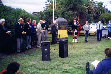
Photograph, 'Glen Huntley' 150th anniversary of arrival - images collection
Victorias first quarantine station was established in Port Ormond on 24 April 1840 when the government immigrant ship "Glen Huntley" arrived in the Port Phillip District flying the yellow quarantine flag . The site is marked by a cairn and plaque that was unveiled in 1985. In 1990 a second plaque was affixed to the cairn to mark the 150th anniversary of the arrival of the ship. It was unveiled at a gathering of descendants of the original passengers on 22 April 1990 by the oldest known descendant, Albert John Buntine MM.Colour photographInscription on 150th anniversary plaque: This plaque commemorates the 150th anniversary of the arrival of the ship 'Glen Huntley' at a gathering of descendants of the original passengers. Unveiled on April 22nd 1990 by Albert John Buntine MM, aged 95. Oldest known descendent. Anderson, Davidosn, Dingwall, McCleery, McDougal, McIntosh, Pattison, Somerville, Brisbane, Kirkwood, McGaskell, McDonald, McGregor, McKenzie, Turnbull, Walker, Armstrong, Henderson, Mathewson, McPherson, Robertson, McKinnon, Whitlock, Stewart, Cameron, Cummins, Hewison, Maskill, Mathers, McKinan, McKinny, McLaren, Burnie, Clarke, Denham, Fraser, Harper, Mercer, McColl, McLeod, Clarke, Duff, Roy, Seat, Stow, Tait, Ward, Craig, Grant, McKay, Mefan, Munro, Nicol, Smith, Young. The plaque marking the 150th anniversary of the ship's arrival was placed below the plaque that was attached to the cairn in 1985. The inscription on the original plaque is: This cairn marks the site of Victorias first quarantine station, which was established on the 24th April 1840 when the government emigrant ship "Glen Huntley" arrived in the Port Phillip District flying the yellow quarantine flag. The site became St Kilda's first official burial ground and the graves of the early colonists remained here until 1898 when the remains were re-interred in the St Kilda Cemetery. Unveiled by the Hon. R W Walsh MLA Member for Albert Park, Minister for Public Works, Assistant Minister for Employment and Industrial Affairs, 7th November 1985. This project was initiated by the Historical Society of St Kilda and sponsored by the Lions Club of Elwood for the 150th Anniversary of the State of Victoria. Logo Victoria 150.glen huntly, glenhuntly, albert john buntine, elwood, point ormond, glen huntley -
 St Kilda Historical Society
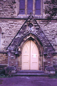
Photograph, Christ Church St Kilda exterior - images collection #2
Christ Church was constructed in 1854-57 and designed in Decorated Gothic style by Albert Purchase & Charles Swyer. It was enlarged in 1874 and 1881 to the designs of Sydney W Smith. It is one of four main buildings constructed on land granted to the Church of England in 1855 and named Church Square. The other buildings are the bishop's residence, vicarage and parish hall. Heritage Victoria describes it as a 'rare and significant square in the history of town planning in Victoria which demonstrates the importance of the church to the community'. It is built from rarely used undressed random coursed sandstone from Point King Sorrento. It is located at 14 Acland Street, St Kilda. The triangular rose window is said to have been modelled on Lichfield Cathedral and shows outstanding craftsmanship. According to Heritage Victoria, the only other known example in Victoria is at St Georges Presbyterian Church in East St Kilda, designed by the same architect, Albert Purchas. The Church has a varied collection of stained glass, including work by leading stained glass firms and artists in Victoria in the nineteenth and early twentieth century: Ferguson & Urie, William Montgomery and Brooks Robinson. The 'shipwreck window,' north west transept, is an historically significant memorial window dedicated to Miles and William Dalzell Nicholson, the second and third sons of the Hon. William Nicholson, M.L.A, a Lord Mayor of Melbourne and Premier of Victoria in the 1850s. Miles, died in England on 27 April 1874. His younger brother William died in the wreck of the ‘British Admiral’ off King Island on 23 May 1874. The images show the condition of the church at the time they were taken (c 2012). Signs of deterioration can be seen. The bell is not rung any more because of damage to the stonework.There has been some remedial work since and the National Trust of Australia conducted a heritage restoration appeal.churches, acland street, purchase, swyer, st kilda, christ church -
 St Kilda Historical Society
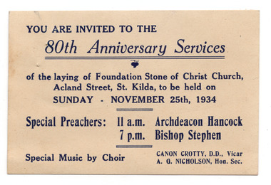
Ephemera - Invitation, 80th Anniversary Services, 1934
Invitation to services commemorating the 80th anniversary of the laying of the foundation stone of Christ Church, at 14 Acland Street St Kilda, on 25 November 1934. Christ Church was constructed in 1854-57 and designed in Decorated Gothic style by Albert Purchase & Charles Swyer. It was enlarged in 1874 and 1881 to the designs of Sydney W Smith. It is one of four main buildings constructed on land granted to the Church of England in 1855 and named Church Square. The other buildings are the bishop's residence, vicarage and parish hall. Heritage Victoria describes it as a 'rare and significant square in the history of town planning in Victoria which demonstrates the importance of the church to the community'. It is built from rarely used undressed random coursed sandstone from Point King Sorrento. White card, discoloured with aged, printed in dark blue on one side.christ church, acland street -
 Unions Ballarat
Photographs: Unions Ballarat building renovations 2018, 2018
The Ballarat Trades Hall building is located at 24 Camp Street, Ballarat. The foundation stone was laid in October 1887. (Architects were Messrs James and Piper and builders were Messrs Lietch and Outtrim.) Over several decades, the façade of the building has fallen into disrepair and was posing a safety risk. Thanks to Victorian heritage grants and ongoing public donations, refurbishment of the façade is currently underway by Troon Pty Ltd. The photos in this entry show the deterioration of the building and the progress in restoring it to its former state. Progress catalogued by date: 13 February 2018 - 1 photo 19 February 2018 - 1 photo 23 February 2018 - 1-6 photos 5 March 2018 - 1-5 photos 12 March - 1 photo 4 April 2018 - 1-6 photos 18 April 2018 - 1-7 photos 23 April 2018 - 1 photo. The top of our restored building starts to poke out as the scaffold comes down level by level - the rendered wash-coat colour looks fantastic in the sun - as close as we can get to the original 1887 colour.The Hall is a community hub in Ballarat as well as being the point of contact and activism for unions and unionists in the area. These photographs are a critical part of the building's history.Photographs of Ballarat Trades Hall renovations. btlc, ballarat regional trades and labour council, ballarat trades hall, building, building fund, james and piper, lietch and outtrim, troon pty ltd, building - resoration, heritage victoria, grants -
 Ballarat Heritage Services
Photograph - Photograph - Colour, Lisa Gervasoni, Remains of Angus McMillan's Bushy Park Home, 2014, 07/06/2014
Angus McMillan was born in 1810 at Glenbrittle in the Isle of Skye. He was one of fourteens sons of Ewan McMillan. Angus McMillan arried i New South Wales in January 1839, and became an overseer for Captai nLachlan Macalister. I n 1839 Angus McMillan travelled south. He settled for a time on Jame MacFarlane's statin at Currawong. IOn 28 May 1839 Angus MacMillan stated travelling southward toward the coast. Angus Macmillan named the Avon River after the river of the same name in his native Scotland. In 1840 he established a pastoral run at Bushy Park, near Maffra. William Odell Raymond established a run in the area in 1842, and built his house, Strathfieldsaye, during 1848–54. European settlement did not take place without resistance, and in return, massacres were inflicted by Angus McMillan and others on Gunai people, especially between the years of 1840 and 1850. (wikipedia) The first application for the 'Bushy Park' run appears in the “Port Phillip Gazette” on 13 August 1843. It was taken up by Angus McMillan, who also took up the 'Boisdale' run for his employer Lachlan Macalister at the same time. In March 1844 a Licence to occupy the 16,000 acre 'Bushy Park' was granted to McMillan. In the late 1840s Andrew Martin and Matt McCraw built Angus McMillan's Bushy Park homestead. Aboriginal killings in Gippsland area most often were never formally recorded, but lived on in folklore, mainly in place names pinpointing what some historians now refer to as "massacres", and others as "conflicts". There is Boney Point, on Lake Wellington, Butchers Creek, near Metung, Slaughterhouse Gully, at Buchan, Skull Creek, at Lindenow, and, notoriously, Warrigal Creek, at Woodside. "Here, according to a couple of contemporary - though not eyewitness - reports, between 50 and 150 blacks were killed in an orgy of revenge after the murder and mutilation of a leading Scots settler, Ronald Macalister. If anybody had any doubts about the fitness of commemorating McMillan's name, no one voiced them then. Gippsland was, and still is, dotted with stone cairns tracing his route from Omeo, down the Tambo Valley to the fertile plains where he was to make (and lose) his fortune. And where, according to a growing body of opinion, he was to lead the "Highland Brigade", a band of armed settlers, against the Kurnai. History is fiction agreed on, and it is written by the winners. For most of the past 150 years, McMillan has been hailed as a trail-blazing pioneer. The legend began to crumble 20 years ago with publication of new histories, which at first outraged Gippsland historical societies and old residents, but which have gradually changed the way McMillan is viewed. ... Still, not all McMillan's contemporaries agreed with the "Highland Brigade" and its methods. Henry Meyrick, an English-born squatter, wrote to relatives in disgust about his neighbours. He estimated that 450 had been killed, and wrote: "Men, women and children are shot down whenever they can be met with. Some excuse might be found for shooting the men by those who are daily getting their cattle speared, but what they can urge in their excuse who shoot the women and children I cannot conceive." (http://www.theage.com.au/articles/2002/04/26/1019441303552.html, accessed 20 September 2016.) The Gippsland electorate is called 'McMillan' in his honour. Photographs of the remains of a timber home used by squatter Angus McMillan at his "Bushy Park" property on the Avon River. angus mcmillan, bushy park, avon river, squater -
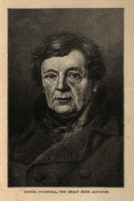 Ballarat and District Irish Association
Image, Daniel O'Connell, the Great Irish Agitator, c1864, c1864
Daniel O’Connell was born near Cahirciveen, Co. Kerry, on 6 August 1775. His wealthy childless uncle adopted him at an early age and brought him up at Derrynane. He spoke Irish and was interested in the traditional culture of song and story still strong in Kerry at the time. He also understood how the rural mind worked which served him well in later years. In 1791 he was sent to school at St. Omer and Douai and what he saw there of the French Revolution left him with a life-long hatred of violence. He read law at Lincoln’s Inn (1794 -96) and continued his studies in Dublin where he was called to bar in 1798. He had soon built up an enormous practice. The 1798 rising and the terrible butchery that followed it confirmed his horror of violence. While he approved of the principles of the United Irishmen, their call for reform and for Catholic Emancipation, he disagreed with their methods. In 1815 O’Connell criticised harshly the Dublin corporation. O’Connell was challenged to a duel by one member D’Esterre. In the exchange of shots D’Esterre was killed and O’Connell vowed never to fight again. O’Connell was soon drawn into political action. Hopes of Catholic emancipation had been raised by promises given while the act of union was being passed. In 1823, O’Connell founded the Catholic Association. The aim of the organisation was to use all the legal means available to secure emancipation. It turned into a mass crusade with the support of the Catholic clergy. All members of the association paid a membership of a penny a month (the Catholic rent). This helped to raise a large fund. The Clare election in 1828 was a turning point. O’Connell, with the support of the forty-shilling freeholders, managed a huge victory against the government candidate. He was well supported by the clergy whose influence on the poor uneducated peasant class was enormous. The polling took place in Ennis at the old courthouse where the O’Connell monument now stands. At the final count, O’Connell was elected by a majority of about eleven hundred votes. The ascendancy party had suffered its first big knock since 1798. The whole country was aflame. The British Government feared a rising and granted Catholic emancipation in April 1829. The franchise was, however, raised to 10 pounds which excluded the forty-shilling freeholders. O’Connell was now the undisputed leader in Ireland and he gave up his practice at the bar to devote his time entirely to politics. At the King’s insistence, O’Connell was not allowed to take his seat until he had been re-elected for Clare. In February 1830, O’Connell became the first Catholic in modern history to sit in the House of Commons. For the rest of his life, he was supported by “The O’Connell Tribute”, a public collection out of which O’Connell paid all his expenses. O’Connell now decided to concentrate on winning repeal of the act of union and getting an Irish parliament for the Irish people. British political leaders feared repeal as they did not fear emancipation. They saw repeal of the Act of Union as the first step in the break-up of the act of union, as the spirit of the repeal movement was revived when the young Ireland writers wrote about it in the Nation. In 1841, O’Connell was elected Lord Mayor of Dublin and in 1843 the subscriptions to his Repeal Association, the Repeal “Rent” came to 48,400 pounds. He now began to organise monster meetings throughout the country. It is thought that three-quarters of a million people gathered on the hill of Tara to hear the man they called the “Liberator”. The government became alarmed at the strength of the Repeal Movement and a meeting which O’Connell had planned for 8 October 1843 in Clontarf, Dublin was banned. Huge crowds were already on their way when O’Connell called off the meeting to avoid the risk of violence and bloodshed. He was charged with conspiracy, arrested and sentenced to a year in jail and a fine of 2,000 pounds. The sentence was set aside after O’Connell had been three months in prison. When he was released he continued with his campaign for repeal. However, a turning point had been reached. The tactics that had won emancipation had failed. O’Connell was now almost seventy, his health failing and he had no clear plan for future action. There was discontent within the Repeal Association and the Young Irelanders withdrew. There was also some failure in the potato crop in the 1840’s, a sign of things to come in the Great Famine of 1845-1847. Aware of the fact that he had failed with his great goal, (the Repeal Movement), O’Connell left Ireland for the last time in January 1847. He made a touching speech in the House of Commons in which he appealed for aid for his country. In March, acting on the advice of his doctor, he set out to Italy. Following his death in Genoa on 15 May 1847, his body was returned to Ireland and buried in Glasnevin Cemetery. [http://www.clarelibrary.ie/eolas/coclare/people/daniel.htm, accessed 13/12/2013]Portrait of a man known as Daniel O'Connell.ballarat irish, daniel o'connell, o'connell -
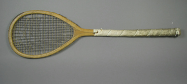 Tennis Australia
Racquet, Feb 1874
A tilt-top Sphairistike lawn tennis racquet, with solid concave throat, leather crown protector, and white leather handle grip wrapped along almost the whole length of the shaft. Impressed inscription along throat and shaft on obverse: FRENCH & CO./46 CHURTON ST./LONDON/SPHAIRISTIKE. This historical racquet was literally one of the first lawn tennis racquets - sold as part of a lawn tennis set - to be produced by French & Co., upon the order of Major Wingfield, in anticipation of the patenting and publication of his game rules. Once the patent was granted, Wingfield had his rules published in two days, and had copies slipped into the already constructed French & Co. tennis sets, and from that point, the lawn tennis craze began. Materials: Wood, Lacquer, Glue, Metal, Gut, Leather, Inktennis -
 Wangaratta High School
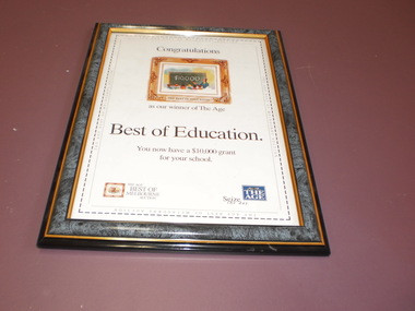
WHS Framed Certificate
White certificate in a black, grey and gold frame featuring in image of a framed painting of a teacher pointing to a blackboard with $10,000 written on it and two small logos at the bottom of the page. Black text below reads:Congratulations as our winner of The Age Best of Education. You now have a $10,000 grant for your school/ -
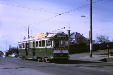
 Ballarat Tramway Museum
Negative, Geoff Grant, Feb. 1954
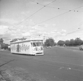
Negatives No. 270 and 271 and colour print made by colour laser printer (stored in folder ) of Melbourne PCC tram No. 980 decorated for the Royal Visit. Two negatives very similar. No. 271 slightly closer up by corners have light coming in. Envelope describes the negatives as "Especially decorated tram from Royal visit. It was the PCC tram done up. At Caulfield on the Darling Road, Pt Ormond Line. Feb. 23, 24, 25, 26 '54". 2 views side on". Photo by Geoff Grant. Negative scanned and image updated 19/5/2020.trams, tramways, pcc, point ormond, caulfield, darling road, tram 980 -
 Ballarat Tramway Museum
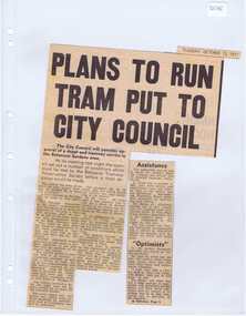
Newspaper, The Courier Ballarat, "Plan to run tram put to City Council", 12/10/1971 12:00:00 AM
Newspaper clipping from The Courier, 12/10/1971, titled "Plan to run tram put to City Council" about the City of Ballaarat considering plans from the BTPS for the construction of a depot in the South Gardens Reserve, consideration of a grant of $750 for the sheltering of tram No. 14. Quotes President Hal Cain about the proposals of the Society, and elements of the submission to council requesting assistance to run the track from View Point to Carlton St. Sir Arthur Nicholson said "super optimists", refers to the editorial.. Cutting in two parts.btps, depot, city of ballarat, preservation -
 Ballarat Tramway Museum
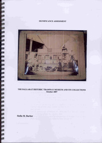
Document - Report, Stella Barber, "Significance Assessment - The Ballarat Historic Tramway Museum and its Collections Oct. 2007", Jan. 2008
Yields information about the BTM collection as at 2007 and has a strong association with the work of Stella Barber.Seventy One page report, within plastic front cover and black card rear cover, wire bound, titled "Significance Assessment - The Ballarat Historic Tramway Museum and its Collections Oct. 2007". Written by Stella Barber of SMB Wordsmith for the BTM with a grant from Heritage Victoria. Completed Oct. 2007. Examines the significance overall of the BTM collection, has many illustrations of objects within the collection and looks at their significance from a Museum point of view. Illustration in black and white and colour. Document held on CD as well. Page 71 has notes on Stella Barber with a photograph. Copy printed by BTM 1/2008. trams, tramways, btm, significance, collection management, collection -
 Ballarat Tramway Museum
Photograph - Digital image Set of 10, Tony Smith, 1971
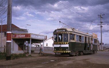
Yields information about Ballarat Tramways and trams prior to the closure of the tramway system.Set of 10 digital images of Ballarat trams prior to closure, scanned from original slides by Tony Smith, 1971 prior to closure of the system. .1 - 42 in Barkly St - at top of hill, outbound to Mt Pleasant. Note the fire alarm on the right hand side of the photo. .2 - 42 and 21 crossing at Grant St Loop, Barkly St, Mt Pleasant. 42 outbound, 21 inbound. .3 - 34 and 21 crossing at Parker St Loop, with Ballarat College in the background. 42 in bound to City and Mt Pleasant, 21 showing Sturt St. West. .4 - 21, Wendouree Parade at the south end of the old parking loop. .5 - 42 and 21 crossing at Gardens Loop. 42 showing Mt Pleasant, 21 Gardens via Sturt St West. .6 - ditto .7 - 41 showing Special at intersection of Ripon St and Sturt St with a single trucker tram ex View Point waiting to turn into Sturt St. 41 has two Johnnie Walker Whiskey roof advertisements. .8 - Two single truckers - not well focused - 21? and 13? crossing at Mill St loop, has the hospital in the background. Conductor leaning out of the door on the outbound tram. .9 - 42, bogie tram and a single trucker at the City terminus (Sturt and Lydiard Sts). Has a group of SEC trammies standing alongside the tram. Has Racey's store and the SEC offices in the background. 42 has a briquettes roof advert. .10 - 34 in Sturt St, at the City terminus, with passengers getting onto the tram. Has the Town Hall, Myers store, Gemmola's Pharmacy in the background. Tram has the destination of Gardens via Drummond St. Nth. Has two trammies (crews) standing alongside the tram stop sign.trams, tramways, sturt st west, barkly st, grant st, parker st loop, sturt st, view point, ripon st, mill st loop, crews, town hall, tram 42, tram 21, tram 34, tram 41, tram 42 -
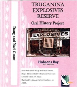 Truganina Explosives Reserve Preservation Society Inc (TERPS)
Digitised Oral History – Truganina Explosives Reserve - Tape 1 Doug and Noel Grant, 2018
The interviews were recorded in 2000 by Bronwen Gray and Alan Young for the production of Unreserved, Stories from Truganina Explosives Reserve, animated stories from past residents, workers and interested people of the Reserve (subject to copyright 2004). Doug and Noel Grant’s Grandfather, Don Grant, was officer in charge of Truganina Explosives Reserve from 1910-1930. On his retirement, his son, William (known as Bill) took over the position until 1956. Along with their two older brothers and younger sister, Doug and Noel Grant grew up, first in the assistant manager’s weatherboard cottage and then in the brick house which was set aside for the officer in charge, until they married and moved into their own homes in their early 1920s. On returning from the second world war, Noel Grant worked as a magazine assistant of explosives on the site from 1946, When the site had closed down in 1962 he worked as an inspector of explosives at the Explosives Branch in Melbourne until he retired in 1985. During that time Noel was asked to move back on site, meaning that three generations of Grants have lived on the site during the twentieth century. Doug Grant worked for ICI/Nobel in head office in 1940 and their older brother Alan worked at the Nobel Explosive Company in Deer Park from 1937. After returning from the Second World War, Alan bought a transport business that had once had the licence to cart explosives in and around the state. They discuss their memories of the living at Truganina Explosives Reserve and the workings of the Reserve, including the names of men who worked there, ships which carried the explosives and life in and around Altona. A primary source of information on memories of the Truganina Explosives Reserve and Altona,VictoriaDigital copy of original cassette recorded in 2000 and digitised in 2018hobsons bay, altona, galvanised iron fence, picket fence, golf course, altona school, margaret grant, bill grant, explosives magazine, lighters, joe hyde, alex grant, pines scout camp, maribynong river, 1896, inspector of explosives, pier, point wilson, werribee sewerage farm, george grant, lighterman, huia, argonaut, pirie, alma doepel, merton street altona, horse, jessie grant, jean grant, sandal, kilmartin, lewis, currie, todd, robinson, balwyn -
 Truganina Explosives Reserve Preservation Society Inc (TERPS)
Digitised Oral History – Truganina Explosives Reserve - Tape 7 Cliff Gibson, 2018
The interviews were recorded in 2000 by Bronwen Gray and Alan Young for the production of Unreserved, Stories from Truganina Explosives Reserve, animated stories from past residents, workers and interested people of the Reserve (subject to copyright 2004). Cliff Gibson, a Williamstown resident, discusses the handling and shipping of explosives in the Port of Melbourne between 1863 to 1962 and the establishment, development and history of Truganina Explosives Reserve. In the interview he mentions the names of the Lighters and Ships used to transport the explosives to and from the Truganina Explosives Reserve. A primary source of information on memories of the Truganina Explosives Reserve and Altona,Victoriaexplosives, lighter, sailing lighters, the brig martha, deer park, australian chemical company, nobel explosives company, ici, james scott and company, jacks magazine, william wardell, george thomas chirnside, 1897, 1901, pier, bill grant, james mullins, 2 foot gauge tramway, explosives trucks, explosive magazines, railway explosives vans, queen street, richard rendle holten, ports and harbours, the lighter truganina, the lighter george stone, rose, mary jane, tarniet, derrimut, boonah, deutgam, naval dockyards williamstown, charlie curry, powder barges, cargo net, alma doepel, huia, wongalla, joseph sims, argonaut, maryland, pirie, lady isobel, taranui, point wilson, failee, captain dyson, hector pirie -
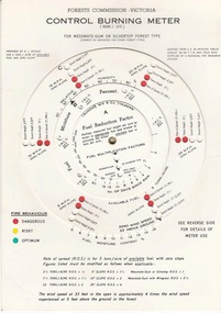 Forests Commission Retired Personnel Association (FCRPA)
FCV Control burning meter, 1970
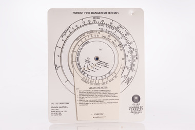
The Forest Fire Danger Index (FFDI) was originally invented by the grandfather of Australian bushfire science, Alan Grant McArthur, during the 1950s and ‘60s. Alan published his landmark paper, “Controlled burning in eucalypt forests” in 1962. Leaflet No. 80, as it was known, proved a turning point for forest and fire managers across Australia. More importantly, Alan was very practical forester and wanted his work to be useful to people in the field, so after several iterations he came up with the now familiar circular slide rule called the Forest Fire Danger Meter (FFDM). The Mk 4 version first appeared in operational use in 1967. Two Forests Commission staff, Athol Hodgson and Rus Ritchie, built on McArthur’s pioneering work and by applying their own practical experience, developed a modified version in the late 1960s called the Control Burning Meter which was better suited to Victorian forest conditions.Introduced to the FCV in 1970Control burning meterbushfire, forests commission victoria (fcv) -
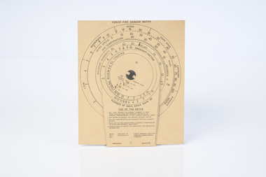 Department of Energy, Environment and Climate Action
McArthur Forest Fire Danger Meter MK5 1973
The Forest Fire Danger Index (FFDI) was originally invented by the grandfather of Australian bushfire science, Alan Grant McArthur, during the 1950s and ‘60s. Alan published his landmark paper, “Controlled burning in eucalypt forests” in 1962. Leaflet No. 80, as it was known, proved a turning point for forest and fire managers across Australia. More importantly, Alan was very practical forester and wanted his work to be useful to people in the field, so after several iterations he came up with the now familiar circular slide rule called the Forest Fire Danger Meter (FFDM). The Mk 4 version first appeared in operational use in 1967. This is the Mark 5 from 1973Alan McAthur's scientific legacy with the FFDI meter is unquestionably huge and has served forest firefighters very well over the decades.Cardboard fire danger meter Series of circular slide rules to calculate Forest Fire Danger Index (FFDI)forests commission victoria (fcv), bushfire -
 Ballarat Tramway Museum
Slide - Set of 7, Warren Doubleday, Ballarat - last Saturday of full operations, 21/8/1971
Photos taken on the last Saturday of full operations by the SECV in Ballarat prior to the first closure of the Victoria St line on 22/8/1971. 1 - Tram 42 running a special inbound in Albert St Sebastopol with a closed Antiques shop in the background. 2 - Trams 26 and 30 Grant St loop on the Mt Pleasant line. 3 - Tram 39 using the Dawson St cross over with tram 26 behind. 4 - Tram 26 on Dawson St cross over 5 - Tram 31 or 32? in Lydiard St north crossing over the level crossing with Reids Coffee Palace, the Provincial Hotel and the signal gantry in the view. 6 - Running through the Gardens with the McDonald Gates and a wedding. 7 - Tram 30 turning from Macarthur St into Wendouree Parade View Point with the tram stop shelter and Swans in the view.Yields information about the last full Saturday of SEC Tramway operations in Ballarat and has a strong association with the archivist. Set of 7 Kodachrome colour slides - cardboard mountsHave the photographer's slide numbers written on them.trams, tramways, closure, tram 26, wendouree parade, barkly st, tram 42, tram 30, level crossing, lydiard st nth, railway, ballarat station, view point, macarthur st -
 Trafalgar Holden Museum
Vehicle - VN Commodore, 1988
The VN Commodore was available in Executive, S, SS, Berlina and Calais specification levels, although a more basic SL model (opt. code A9K) was supposedly offered to government and fleet buyers, as it was not officially listed as part of the Commodore range. Changes in the relative values of the Australian dollar, the Japanese yen, and the US dollar made it impractical to continue with the well-regarded Nissan engine of the VL. Instead, Holden manufactured their own 90-degree V6 based on an old Buick design from the US, although initially it was imported. The 5.0-litre V8 remained optional and received a power boost to 165 kW (221 hp). Both these engines used multi point GM EFI and the V6 using 3 coil-packs for ignition. Holden and HSV developed this car as the basis for racing in Group A Confederation of Australian Motor Sport events. While the minimum number of cars built to qualify in Australian Touring car Championships, with modified body kit, brakes or engine is 500, only 302 VN were built but CAMS granted an exemption allowing them to compete.Holden and HSV had worked hard to develop this car to be a serious competitor to the Skyline, Ford Sierra and the BMW which had dominated in the previous years. This was to be the Holden’s answer and coincided with the return of Peter Brock back to the Holden team from 1987.Mechanically the cars were fitted with reworked version of Holden’s 4.9 litre V8. The engine block was cast for additional strength, modified cylinder heads roller rockers and high fuel flow fuel injection was applied. Output was 215 kw at 5200revs and, though at today’s standard, that is not that much it was very impressive at that time. The drive was through a six speed ZF gearbox with a heavy duty racing clutch and a limited slip differential.Under the Hawke government's Button car plan, which saw a reduction in the number of models manufactured locally, and the introduction of model sharing, the VN Commodore was rebadged as the Toyota Lexcen, named after the late America's Cup yacht designer, Ben Lexcen. Subsequently, the Toyota Corolla and Camry were, similarly, badged as the Holden Nova and Holden Apollo.Red executive 4 door sedanHolden Lion and stone emblem grille centre, Commodore boot LHS, Lion and stone emblem boot RHS.vehicle, vn commodore, holden, car -
 Federation University Historical Collection
Document - Documents, Documents Relating to the Re-establishment of the Golden Point - Mt Pleasant Progress Association, 1983-1997, 1983-1997
Mara Gluyas was secretary of this organisation for 11 continuous years (1983-1994), and President Ian McKinnon was President for 9 years from 1983-1992). The inaugural 1983 committee was Ian McKinnon, Mara Gluyas, N. Strange, A. Graham, M. Davidson, M. Adams, Peter Hiscock, Ian Blomeley. The Association was concerned with the advancement of the Ballarat area in general and to promote Golden Point - Mt Pleasant area in particular. Small box with purple lid filled with the constitution, minutes associated with the Golden Point - Mt Pleasant Progress Association, and lists of members.mara glouyas, ian mckinnon, sovereign hill, pearce's park rotunda, elms, tree planting, sovereign hill lookout reserve, christmas carols, mine collapse, former golden point direction indicator, signage, norm strange, golden mount historical mines direction indicator, yarrowee creek tree planting committee, peady street, pearce street, barry davis, nerrina tip, ballarat observatory, carols by candlelight, yarrowee park project, magpie street bbq park, neighbourhood watch, magpie street park, cobden street, pryor street bus shelter, hill street, urban wildlife corridor, south street bluestone gutter, eastern baths site, grant street, street lighting, magpie street, letterhead, aboriginal advancement league, golden point primary school, sunnyside woollen mill, ballarat west goldfields, fred hunt, kerry daniell, craig ford, jack colin greville, jack colin greville plaque at mt pleasant lookout, golden point school oval -
 Forests Commission Retired Personnel Association (FCRPA)
McArthur Forest Fire Danger Meter - Mk 5, 1992
The Forest Fire Danger Index (FFDI) was originally invented by the grandfather of Australian bushfire science, Alan Grant McArthur, during the 1950s and ‘60s. Alan published his landmark paper, “Controlled burning in eucalypt forests” in 1962. Leaflet No. 80, as it was known, proved a turning point for forest and fire managers across Australia. More importantly, Alan was very practical forester and wanted his work to be useful to people in the field, so after several iterations he came up with the now familiar circular slide rule called the Forest Fire Danger Meter (FFDM). The Mk 4 version first appeared in operational use in 1967. This is the Mark 5 from 1992Alan McAthur's scientific legacy with the FFDI meter is unquestionably huge and has served forest firefighters very well over the decades.Control burning meter Series of circular slide rules to calculate Forest Fire Danger Index (FFDI)bushfire, forests commission victoria (fcv) -
 Melbourne Tram Museum
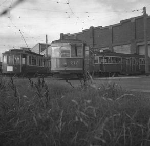
Negative - Set of 2, Possibly Geoff Grant, c1950
Set of two Black and white negatives of trams at Preston Workshops .1 - Trams - Freight car 19. X class 217 and a W2. The X has the destination of Point Ormond. .2 - Freight tram 19 - side on view. Photo not in Wal Jack Melbourne album.trams, tramways, preston workshops, x class, w2 class, freight tram, tram 19, tram 217 -
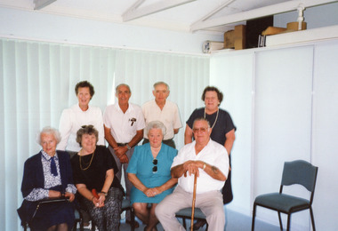 Lakes Entrance Historical Society
Photograph, George and Sarah Grant, 2000 c
... are descended from George and Sarah Grant settlers at Shaving Point... settlers at Shaving Point Metung George and Sarah Grant Photograph ...Colour photograph of eight people five of the group are descended from George and Sarah Grant settlers at Shaving Point Metunggenealogy, celebration -
 Federation University Historical Collection
Book - Copies of newspaper articles, Ballarat Academy of Performing Arts Press Releases 1997, 1997
Reports published in The Courier newspaper of performances by Ballarat Academy of Performing Arts, including items naming students past and present of the University of Ballarat during 1997 plus articles of people and events connected to the Arts Academy. Also contains information about Ballarat University courses for performing arts. Articles are mostly from the Ballarat Courier newspaper in chronology year (1997) order with no page numbers. Two items are from December 1996 and three articles in October 2001. PRODUCTIONS : *' Pericles' performed by Ballarat's Ozact Theatre Company at Port Fairy's Battery Point. *'Maelstrom' written by Chris Dickens and directed by Peter Tulloch performed by BAPA third year students.(Oct. 28th - Nov 1st) Some cast members were: James McLaverty, Melissa Casey, Linda Judd, Angela Coad, Sarah Griffin, Kathy Lucas, Melissa Casey, Laura Hill, Grant Hickey, Jamie Robertson, Jon Catanzariti, Steve Kerr, Jeff Parker Natalie Zappulla. Performed at Ballarat University Studio Theatre (Nov 4th -8th) and also at Melbourne's CUB Malthouse (Nov. 25th-29th) *"7 Deadly" directed by Chris Dickens and performed in The Chapel at the Academy's Victoria Street campus by 1st year Ballarat University students. Some cast members were: Ash Abdou, Niniane Le Page, Alex Meerbach, Adam Davies and Elicia Bolger. *"Sounds of Broadway and Off' (Oct 9th - 11th) directed and choreographed by Judith Roberts and performed at the Studio Theatre , University of Ballarat, by 1st year students of Musical Theatre at BAPA. Some cast members were Paul Thomas, Shannon Palmer, Aakash Andrews, Justine Schnellbeck, Erica Chestnut,, Rebecca McGuinness, Matthew Heyward, Kellie Rode. Tickets cost $5.00 *'Bewitched" "a parody of the original television series" directed and produced by Ballarat performing arts graduates Adam Turnbull and Claire O'Sullivan. Most of the cast and crew were graduates from the University of Ballarat. Some cast members were: Katherine Evans as Samantha and Martin Cole as Darren. Simon Buckle was responsible for his original music, songs and special effects. *Concert: Featuring pianist Slavomir Zumis and cellist Robert Ekselman (Oct. 3rd) *"Charley's Aunt" by Brandon Thomas, performed by 2nd year Ballarat Academy of the Arts 2nd Year Company at The Venue Studio Theatre, University of Ballarat (Sept. 23rd-27th). Cast members: Derren Jackson, Ross Larkin, Kevin Dee, Adelle Gregory, Colette Bruggeman, Luke Doxey, Gavin Fenech, Dennis Marinovic, Nadia Andary, Narelle Werner. Cost: Adults $10, Concession $7.50, Bookings at Majestix. *'The Importance of Being Ernest' (by Oscar Wilde), performed by second year theatre company of the University of Ballarat, directed by Maureen Edwards, designed by Andrew Arney. Cast members included Narrell Werner as Gwendolen, Tim Haymes as Jack, Mark Gambino as Algermon, Adelle Gregory as Cecily and Heather Kent as Lady Bracknell. The production was at the Studio Theatre, University of Ballarat, September 16th-20th , 8pm. Ticket costs: $10 Adult, $7.50 Pensioners/students. Double bill tickets for The Importance of Being Ernest and Charley's Aunt (Sept.23-27) costs: $15 Adults,$10 Concession. *"The Man From Muckinupin' (by Dorothy Hewett), directed by Chris Dickens and performed by University of Ballarat 3rd Year Performing Arts at Studio Theatre, University of Ballarat from Aug 26th - Aug 30th 1997. Cast members: Lisa Judd as Polly, James McLaverty as Jack, Jamie Robertson, Natalia Rose, Steven Kerr, Jon Catanzariti, Melissa Casey, Grant Hickey, Sarah Griffin, Laura Hill, Kathy Lucas, Angela Coad, and Jeff Parker. Ticket costs: $10 Adults, $7.50 Concession from MajesTix *'The Inspector' (by John Cousins) director Bruce Widdop, performed by the Third Year Graduating Company, University of Ballarat, Ballarat Academy of Performing Arts; at Studio Theatre, University of Ballarat, Aug 19th-23rd, 1997. Cast: Jamie Robertson as the mayor, Jeff Parker as the supposed government inspector, Grant Hickey as Sidney, Melissa Carey as Rose, and Sarah Griffin as Rose's daughter, Laura Hill as the postmaster and Linda Judd as the headmistress. Some 1st year students had cameo roles - Adam Parsons and Adam Davies. *'Cosi' directed by Andrew Seeary and performed by Theatre Movement at the Grainery Lane Theatre, Doveton Street, Balarat. The story has a young, nervous director Lewis, played by Brett Edginton, arrive in a mental home to produce a play with the inmates. Other cast members are Karl Hatton (Roy), Miranda Crellin (Cherry), Rob MacLeod (Henry), Ray Craven (Zac), Narrell Werner (Julie), Nadia Andary (Ruth), Mark Gambino (Doug), Elizabet Stewart and Michael Cooper (Lewis' unsympathetic friends) and Bob House (the Social Worker). Nadia, Mark and Narelle are Ballarat University performing arts students. Season: July 24th,25th 26th and 31st and August 1st and 2nd, 1997. Tickets at the door or through Majestix. Cost: Adults $16; Concession $11. Reviewer: Barry Breen, a Ballarat author, poet and performance artist. *'New Works' involves two plays - 'The Inside Out', director Melissa Casey and 'Secrets'. director Jeff Parker, presented by Ballarat Academy of Performing Arts Third Year Company, both written and directed by third year students. All production areas handled by students of BAPA. Cast members: 'The Inside Out' - Jamie Robertson, Laura Hill. 'Secrets' - Sarah Griffin, Linda Jude, Steven Kerr, Angela Coad, Natalie Zappulla. Staged at University of Ballarat's Studio Theatre. Bookings MajesTix - $10 or $7.5 *Euripide's, 'The Bacchae', a tale of revenge, directed by Bruce Widdop and performed by 2nd year students from the University of Ballarat Performing Arts Department and the BAPA. Assistant directors' Tim Haymes and Derren Jackson. Cast members: Richard DiGregorio (Dionysus), Chris Stipic (Cadmus), Colette Brugman (Agaue), Denis Marinovic (Pentheus), Mark Gambino (Teiresias) and Ross Larkin as the messenger. Other supporting performers are Luke Doxey, Brendan Mayne, Heather Kent, Kevin Dee, Gavin Fenech, Nadia Andary, Karissa Clarke, Adelle Gregory and Narrell Werner. The play was performed at the Studio Theatre, Ballarat University, June 3rd-6th, 1997.Tickets MajesTix or at the door - $10 Adult, $7.50 Concession. *'Back to the Tivoli' School of Performing Arts - June 10th -14th. Venue: Academy of Performing Arts, Victoria Street, 8pm *Aristophane's 'Lysistrata', an anti-war comedy. Performed by first year drama students from the University of Ballarat and BAPA at the Studio Theatre, University of Ballarat, Mount Helen, on May 27th-30th, 1997. Cast members: Niniane Le Page (Lysistrata), Fiona Russell (Calonice), Anne Winter (Myhrrine), Dominic Phelan (Cinesias), Alex Meerbach (Stratyllis), Michael Rafferty (Leader), Melissa Lowndes (Lampito), Renee Francis (Ismenia), Kathryn Martin (Corinthian), Geoffrey Spink (doorman), Adam Parsons (magistrate), Adrian Dart (policeman), David Kambouris (policeman two), Max Grarock (negotiator), Phol Crompton (ambassador) and Ross Farrell (herald). Male chorus members: Paul Thomas, Adam Davies, Ashraf Abdou, Karan Khanna. Female chorus members: Lauren Oliver, Suzie, Lewis and Lindy Kerr. Tickets MajesTix - $10 Adults, $7.50 Concession; or $12 special double bill price including The Bacchae. *Roger Woodward Recital - a piano recital by the internationally acclaimed Australian pianist to launch the Ballarat Academy of the Arts asset drive. He performed on the University's historic Erard Grand Concert piano on stage in Founders Hall, describing it as "absolutely amazing.' The instrument was 93 years old and hadn't been played for more than eighty years. An audience of 500 were entertained with pieces by Schubert and Bach for the first half of the program and Waltzes, Mazurkas, and Polonaises by Chopin after the interval. Fittingly an encore of the Minuet in G by Paderewski was played on the very piano the composer had brought from England for his Australian tour in 1906. *'The Merry Wives of Windsor' by William Shakespeare; directed by Beth Child; designer Damian Muller; Production by Third Year Graduating Company, University of Ballarat Performing Arts Department. This play is a comedy not performed very frequently. Cast members: Angela Coad (Mistress Page), Laura Hil (Mistress Quickly), Gavin Fenech (Falstaff), Kathy Lucus (Justice Shallow), Melissa Casey (Mistress Ford), Jeff Parker (Mr Ford), Jamie Robertson ( Mr Page) and Karrissa Clarke (Simple). Staged at the Studio Theatre, University of Ballarat, May 6th-10th 1997 at 8pm. Tickets $10. Concession $7.50. *"Ship of Fools" SMB Performing Arts. Grainery Lane Theatre, 9th-10th May 1997 Cast members: Chris Lytas (Mac & Convinso), Kate Edwards (Mayor & Rachel), Ruth Sheridan (numerous characters) *'Lola Montez - The Musical' author Alan Burke; director Peter Tulloch; choreographer Fred Fargher; designer Damian Muller, musical director Graeme Vendy. Performed by twenty-eight second year Performing Arts students with Nadia Andary in the lead role of Lola,, Grant Hickey as Henry Seekamp the Ballarat Times editor who receives a whipping from Lola for his criticism of her. Tim Haymes is the character Smith, Karissa Clarke plays nurse Jane Oliver and Ross Larkin plays soldier Daniel Brady. Other cast members were Luke Doxey, Richard Di Gregorio, Chris Stipic and Brendan Mayne. A feature of the show is Lola's celebrated Spider Dance which was acknowledged many years ago by the crowd throwing gold nuggets onto the stage. Presented by the Hugh Williamson Foundation in association with the Begonia Festival organizers the performance was at Her Majesty's Theatre, Ballarat nightly from 12th-15th March at 8pm with a matinee at 2pm on the 15th. Tickets at Majestic: Adult $18.50, Concession $13.50, Group Adult $15.50, Group Concession $10.50, Culture Vulture $12.00 Family $46 Season 97. *' 2001- 'On The Town' a musical comedy performed by graduating Ballarat Academy of Performing Arts and directed by course coordinator Kim Durban from the Victorian Theatre Company; and BAPA assistant production manager Jo Pearson. It features a cast of 30 and music from a 15 piece band. Photo depicts three cast members: Keith Miles, Adam Lubicz and Glenn Quinn. It was performed in America in 1944 and tells the story of three sailors who arrive in New York on 24-hour shore leave. It was performed at Founder's Hall, University of Ballarat, Mount Helen campus. Tickets $15 adults, $10 concession and $7 for children and students. Family tickets were available. Bookings MajesTix. *'Play With Your Food' a new theatre restaurant show performed by SMB Performing Arts students at Craig's Cellar, Lydiard Street, Ballarat. It was an original show devised and written by Second Year SMB Performing Arts students. following their sold-out touring show 'unplugged' and Book Week play 'SapceDust'. There are also articles about people involved with the University of Ballarat Performing Arts course and the courses in the Arts. Lady Lush's world of unusual characters presented jokes, songs, music whisked together into a bizarre story for audiences to enjoy and even be tie up. Cast members: Melissa Porritt, Loenne Whitecross, Jess Matthews, Kristie Glab and Julia McNamee. It was performed over five nights, 7th-8th-9th-15th and 16th November, 2001. Cost $20. NEWSPAPER ARTICLES: Directors for University of Ballarat 2nd Year Performing Arts Maureen Edwards (photo) An advertisement for BA Visual Arts - Studio Studies available for Ceramics / Drawing / Graphic Design / Print Making /Painting / Multi-Discipline - Undergraduate and Post Graduate Studies. Also for BA Performing Arts - Major Studies available: Performance Acting, Theatre Production, Performance Music Theatre. Ballarat Academy of Performing Arts - New lecturers 1997: Lecturer in Design and theatre crafts - Damian Muller; lecturer in production and stage management - Leonard Bauska; and lecturer in theatre technology - Matthew Heenan. Ballarat Academy of Performing Arts - 1 st article in 'The Flag' Alumni Newsletter, University of Ballarat, Issue June, 1997 re 1st intake of students in February, 1997. 2nd article 'Where Are They Now' - Amanda Sandwith. Event - 'Lydiard Street Alive' : firebreathing act 'David and Goliath' performed by David Patullo. Article with information (includes advertisment for course) about the 3 year performing arts degree at Ballarat consisting of performance acting, theatre production and performance music theatre which are part of Ballarat Academy of Performi8ng Arts which resources from three institutions - University of Ballarat, Australian Catholic University and the School of Mines. BAPA launch: Photos of some attendees - June 3rd 1997 Ballarat Courier. Performers featured Erica Chestnut and Sue-Ann Thomas. Amy Young - Up Close and Personal article - Ballarat Courier - Saturday June 14 1997. Amy Young was the director and conductress of Ballarat 'Y" Choir for 45 years. In 1996 she donated her husband's (Dr Keith Young) Steinway grand piano and musical collection to BAPA. This article is about her life. Events calendar for the Month of May, 1997. Peter Tulloch ( University of Ballarat Performing Arts Co-ordinator 1997) Newspaper article - interview by Elise Sullivan that appeared in The Ballarat Courier Saturday May 3rd 1997 Weekend Edition . Many articles on Roger Woodward and a $3 million asset drive for the Ballarat Academy of Performing Arts. Advertisement for 3 Arts positions at the University of Ballarat - Lecturers in Theatre for Movement/Dance; Design, Theory and Craft; and Theatre Technology Article: 'Who's Who at the Academy' - A list of First Year, Second Year, Third Year, Performing Arts Staff (University of Ballarat and Australian Catholic University). Article about the Erard Concert Grande piano and its acquisition by the University of Ballarat. There are several articles linked to the production of "Lola Montez the Musical' including: *Lola Montez's life in a timeline -1818 to 1861 compiled by Peter Freund, Her Majesty's Theatre historian on behalf of Ballarat Begonia Festival. * A radio show in 1952 performed by Ballarat's "Y" Drama Group featuring 16 year old Joy Brehaut as Lola Montez and directed by 3BA's Ted Furling *Ballarat's Most Famous Scandal Advertising Poster for Lola Montez *Lola Whips In * Lola to Tread the Boards Again * Lola to Return to Ballarat - The "Minister for Purity, The Reverend John Potter" - (actor Jamie Robertson) * Veteran Takes His First Look at Lola * First Stage Lola meets the New Lola - Nadia Andary meets 1967 Lola, Nancy Brauer. * Lola Returns Home An article listing the 12th Annual Encore Awards held at Ballarat Village on Wednesday 5th March 1997. * Advertisement for major studies available in 1998 -Theatre Performance; Music Theatre Performance and Theatre Production plus upcoming productions - Aug - The Inspector and The Man From Muckinup; Sept - The Importance of Being Ernest and Charley's Aunt; Oct- The London Blitz Show and They Shot Horses Don't They? Nov - Graduate Exhibition * Article 3/12/1996: Amy Young donates her husband Dr. W. H. Keith Young's Steinway grand piano and studio stacked with historic documents to the jointly run Performing Arts Academy following his death. The book consists of A4 paper sheets, heat bound with blue card front and back cover with a plastic overlay. The pages contain photocopied articles printed in the Ballarat Courier during 1997. Two articles are from December 1996.bapa, pericles, ozact theatre company, ozact, maelstrom, chris dickens, joan petering, peter tulloch, 7 deadly, ballarat academy of performing arts, bpca, ballarat college of performing arts, sounds of broadway and off, judith roberts, graeme vendy, bewitched, adam turnbull, claire o'sullivan, katherine evans, martin cole, simon buckle, charley's aunt, brandon thomas, derren jackson, ross larkin, kevin dee, adelle gregory, colette bruggeman, luke doxey, gavin fenech, dennis marinovic, nadia andary, narelle werner, the importance of being ernest, maureen edwards, andrew arney, tim haymes, mark gambino, heather kent, performing arts courses 1997, the man from muckinupin, dorothy hewett, chris dickins, linda judd, james mclaverty, jamie robertson, natalia rose, steven kerr, jon catanzariti, grant hickory, sarah griffin, laura hill, kathy lucas, angela coad, jeff parker, john cousins, bruce widdop, melissa carey, adam parsons, adam davies, damian muller, leonard bauska, matthew heenan, cosi, grainery lane theatre, andrew seeary, brett edginton, karl hatton, miranda crellin, rob macleod, ray craven, elizabeth stewart, michael cooper, bob house, barry breen, the flag, performing arts academy - ballarat, bert labont'e, lydiard stree alive, david and goliath, david patullo, amanda sandwith, bapa launch, erica chestnut, sue-ann thomas, amy young, dr keith young, ballarat "y" choir, the bacchae, richard digregorio, chris stipic, colette brugman, denis marinovic, brendan mayne, karissa clarke, narrell werner, niniane le page, fiona russell, anne winters, melissa lownds, renee francis, kathryn martin, michael rafferty, dominic phelan, geoffrey spink, paul thomas, ashraf abdou, karan khanna, alex meerbach, lauren oliver, suzie lewis, lindy kerr, adrian dart, david kambouris, max grarock, phil crompton, ross farrell, roger woodward, erard grand concert piano, karrissa clarke, beth child, chris lytas, kate edwards, ruth sheridan, ballarat academy of performing arts asset drive, positions - school of arts, erard concert grande piano, ignace paderewski, professor david james, david james, robert allen, bapa opening, gabrielle mcmullen, dr ron wild, graham clarke, michael faulkner, sacred heart convent of mercy ballarat, lola montez the musical, spider dance, lola montez, grant hickey, fred fargher, peter freund, ballarat begonia festival, nancy brauer, james robertson, jo pearson, on the town, keith miles, adam lubicz, glenn quinn, play with your food, melissa porritt, loenne whitecross, jess matthews, kristie glab, julia mcnamee, smb performing arts students, the london blitz show, they shoot horses don't they?, graduate exhibition -
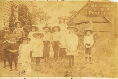 Lakes Entrance Historical Society
Photograph - Grant family, 1895 c
... Grants home on Shaving Point Metung Victoria... and Post Office situated at George Grants home on Shaving Point ...The Village School written by Wendy Male for further informationSepia toned photograph of group of eleven school children and one teacher named are Ethel and Alice Grant and George Ferrera in front of Metungs first school and Post Office situated at George Grants home on Shaving Point Metung Victoriagenealogy, schools