Showing 169 items
matching recreational activities
-
 Vision Australia
Ceremonial object - Object, Harrison Brothers & Howson, Ceremonial trowel
... for social or recreational activities.... of the collection and opportunities for social or recreational activities ...Sir Edward Mitchell was the chairman of the Edward Wilson trust, which enabled the building of the Braille Library during a time of great economic turbulence due to the last months of World War 1. This commemorative trowel was given to him in thanks for his (and the trust's support) of the project, which would ultimately provide a great resource to blinded soldiers who were prepared and able to learn Braille. In addition to the area housing the Braille collection itself, an entrance hall, reading room, secretarial office and hall also provided space for reading, administration of the collection and opportunities for social or recreational activities.1 silver plated trowel with handle inside boxPresented to Sir Edward Mitchell K.C., K.C.M.C. on the occasion of his laying the foundation stone of the new library for the Victorian Association of Braille Writers October 28th 1918. (Inside box lid: By Special Appointment Harrison Bros & Howson, Sheffield, England Cutlers to His Majesty)victorian association of braille writers, sir edward wilson -
 Trafalgar Holden Museum
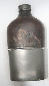
Functional object - Whiskey flask
... during recreational and social activities to hold liquor... during recreational and social activities to hold liquor Sold ...Used in early 19th and 20th centuries, typical flask used during recreational and social activities to hold liquorSold by Holden and Frost C1900'sScrew top glass flask, top half leather bound with metal removable cup coveringflask, drink container, whiskey flask -
 Kiewa Valley Historical Society
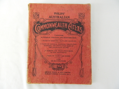
Atlas Australian Commonwealth, Philips' Australian Commonwealth Atlas, 1944
... , grazing, industrial and sporting/recreational activities. Also... and sporting/recreational activities. Also there are snap shots ...This atlas, printed in 1944, details not only the geographic and political boundaries of the world as it was at that time but also the snap shot of life of the time. This snap shot in time covers the major Australian cities, the major farming, grazing, industrial and sporting/recreational activities. Also there are snap shots of similar activities from other global areas. The period also covered World War II, detailed by a photo of "shell making", munitions, required by Australian soldiers. The great political and territorial changes made as a result of World War II can be clearly identified for example , Israel (the Jewish homeland). The various prewar colonies of major European nations.This atlas was used by children of a Kiewa Valley family and shows the value and the general educational exposure that these children had at this time. The rural setting and within the backdrop of a world war did not severely alter the life style of children in this region. The "news reels" shown in cinemas of cities and larger towns were the only visual realisations of major events of global significance available to these children. The information provided by this atlas allowed students to glimpse at what the "outside world" was. The majority of these students would possibly never see these regions for themselves. The great communication facilities of the late 1900s and beyond, was still only science fiction.This atlas has a thick (350 g/m) red cardboard cover with bold black lettering and shading. The cover is set out within a shield like frame. The shield is held up by two square markings, each with a four part circular pattern and a cord entwining two pendulum structures ending with a bowl figure at the bottom. There is a semi circular form enclosing a printed book contents list. The inside cover has the atlas title and contents and the publisher details. The atlas contain 56 pages of world and Australian maps, vegetation and rainfall maps. Within this atlas there are 27 double sided pages of black and white photographs depicting life styles, buildings, landscapes and prominent and significant to Australia males from 1652 to 1944. The pages are of approximately 200 g/m and have the yellow aged appearance.On front cover "Philips' Australian COMMONWEALTH ATLAS" and underneath "Containing" underneath "60 PHYSICAL, POLITICAL AND ECONOMIC MAPS". Publisher George Philip & Son, Limited 32 Fleet Street, London E.C. 4. Inside cover are: written, in freehand and in ink the following names and dates; "J.Muller Form V 1945", "L L Muller Form IV 1946", "N.J. Muller Form I + II + III 1948 +49 + 50" and "D Muller Form I 1949". also handwritten and in pencil is "Peter Leslie". On the last page is a small freehand sketch of Australia in biro.1940s school curriculum, rural education, 1940s atlas, australian atlas -
 Kiewa Valley Historical Society
Photographs – Kiewa Cres Mt Beauty. Circa 1993. Set of 12 colour photographs
... services, accommodation, food and a wide range of recreational... services, accommodation, food and a wide range of recreational ...Established in 1946, during the construction of the Kiewa Hydro Electric Scheme, the township of Mt Beauty was developed by the State Electricity Commission of Victoria to provide additional accommodation for the thousands of workers during the construction of the country’s second largest hydro-electricity scheme. Although these towns were built as temporary accommodation for the workers and their families, many stayed after the scheme finished. Combined with the influx of European migrants, with their rich cultural backgrounds, all played a major part in shaping the future character of the Mount Beauty, the Kiewa Valley and Falls Creek. The Bright Council, now the Alpine Shire took over the control of the township in 1960. This relatively young town of Mount Beauty, along with the surrounding townships of Falls Creek, Bogong, Tawonga South and Tawonga, are all part of a prospering tourist area with excellent services, accommodation, food and a wide range of recreational activities available for all ages. According to Shire records, the population of Mt Beauty has grown from 1,500 in 1981 to 1,800 in 2016 with a projected increase to 2,000 in 2013The photographs taken around 1993 show a prosperous commercial centre catering for both locals and the needs of visitors. It provides a pictorial history of the changes which have occurred in the retail/commercial district of Mt Beauty over the years. It also demonstrates the attention paid by Alpine Shire towards providing accessible recreational green space around the town centre.Set of 12 colour photographs of Kiewa Cres Mt Beauty. Circa 1993 showing retail services and streetscape of the time. No markingskiewa cres mt beauty, mt beauty -
 Kiewa Valley Historical Society
Photographs – Lakeside Avenue, Mt Beauty. Circa 1993. Set of 7 colour photographs
... services, accommodation, food and a wide range of recreational... services, accommodation, food and a wide range of recreational ...Established in 1946, during the construction of the Kiewa Hydro Electric Scheme, the township of Mt Beauty was developed by the State Electricity Commission of Victoria to provide additional accommodation for the thousands of workers during the construction of the country’s second largest hydro-electricity scheme. Although these towns were built as temporary accommodation for the workers and their families, many stayed after the scheme finished. Combined with the influx of European migrants, with their rich cultural backgrounds, all played a major part in shaping the future character of the Mount Beauty, the Kiewa Valley and Falls Creek. The Bright Council, now the Alpine Shire took over the control of the township in 1960. This relatively young town of Mount Beauty, along with the surrounding townships of Falls Creek, Bogong, Tawonga South and Tawonga, are all part of a prospering tourist area with excellent services, accommodation, food and a wide range of recreational activities available for all ages. According to Shire records, the population of Mt Beauty has grown from 1,500 in 1981 to 1,800 in 2016 with a projected increase to 2,000 in 2013The photographs taken around 1993 show a prosperous commercial centre catering for both locals and the needs of visitors. It provides a pictorial history of the changes which have occurred in the retail/commercial district of Mt Beauty over the years. It also demonstrates the attention paid by Alpine Shire towards providing accessible recreational green space around the town centre.Set of 7 colour photographs of Lakeside Avenue, Mt Beauty. Circa 1993 showing retail services and streetscape of the time. No markingsmt beauty, lakeside ave mt beauty -
 Kiewa Valley Historical Society
Photographs – Tawonga Cres., Mt Beauty. Circa 1993. Set of 4 colour photographs
... services, accommodation, food and a wide range of recreational... services, accommodation, food and a wide range of recreational ...Established in 1946, during the construction of the Kiewa Hydro Electric Scheme, the township of Mt Beauty was developed by the State Electricity Commission of Victoria to provide additional accommodation for the thousands of workers during the construction of the country’s second largest hydro-electricity scheme. Although these towns were built as temporary accommodation for the workers and their families, many stayed after the scheme finished. Combined with the influx of European migrants, with their rich cultural backgrounds, all played a major part in shaping the future character of the Mount Beauty, the Kiewa Valley and Falls Creek. The Bright Council, now the Alpine Shire took over the control of the township in 1960. This relatively young town of Mount Beauty, along with the surrounding townships of Falls Creek, Bogong, Tawonga South and Tawonga, are all part of a prospering tourist area with excellent services, accommodation, food and a wide range of recreational activities available for all ages. According to Shire records, the population of Mt Beauty has grown from 1,500 in 1981 to 1,800 in 2016 with a projected increase to 2,000 in 2013The photographs taken around 1993 show a prosperous commercial centre catering for both locals and the needs of visitors. It provides a pictorial history of the changes which have occurred in the retail/commercial district of Mt Beauty over the years. It also demonstrates the attention paid by Alpine Shire towards providing accessible recreational green space around the town centre.Set of 4 colour photographs Tawonga Crescent, Mt Beauty. Circa 1993 showing retail services and streetscape of the time No markingstawonga cres mt beauty -
 Kiewa Valley Historical Society
Photographs – Holland Street North, Mt Beauty. Circa 1993. Set of 18 colour photographs
... services, accommodation, food and a wide range of recreational... services, accommodation, food and a wide range of recreational ...Established in 1946, during the construction of the Kiewa Hydro Electric Scheme, the township of Mt Beauty was developed by the State Electricity Commission of Victoria to provide additional accommodation for the thousands of workers during the construction of the country’s second largest hydro-electricity scheme. Although these towns were built as temporary accommodation for the workers and their families, many stayed after the scheme finished. Combined with the influx of European migrants, with their rich cultural backgrounds, all played a major part in shaping the future character of the Mount Beauty, the Kiewa Valley and Falls Creek. The Bright Council, now the Alpine Shire took over the control of the township in 1960. This relatively young town of Mount Beauty, along with the surrounding townships of Falls Creek, Bogong, Tawonga South and Tawonga, are all part of a prospering tourist area with excellent services, accommodation, food and a wide range of recreational activities available for all ages. According to Shire records, the population of Mt Beauty has grown from 1,500 in 1981 to 1,800 in 2016 with a projected increase to 2,000 in 2013The photographs taken around 1993 show a prosperous commercial centre catering for both locals and the needs of visitors. It provides a pictorial history of the changes which have occurred in the retail/commercial district of Mt Beauty over the years. It also demonstrates the attention paid by Alpine Shire towards providing accessible recreational green space around the town centre.Set of 18 colour photographs Holland Street North, Mt Beauty. Circa 1993 showing retail services and streetscape of the time. No markingsholland st mt beauty, mt beauty -
 Kiewa Valley Historical Society
Photographs – Holland Street South, Mt Beauty. Circa 1993. Set of 16 colour photographs
... services, accommodation, food and a wide range of recreational... services, accommodation, food and a wide range of recreational ...Established in 1946, during the construction of the Kiewa Hydro Electric Scheme, the township of Mt Beauty was developed by the State Electricity Commission of Victoria to provide additional accommodation for the thousands of workers during the construction of the country’s second largest hydro-electricity scheme. Although these towns were built as temporary accommodation for the workers and their families, many stayed after the scheme finished. Combined with the influx of European migrants, with their rich cultural backgrounds, all played a major part in shaping the future character of the Mount Beauty, the Kiewa Valley and Falls Creek. The Bright Council, now the Alpine Shire took over the control of the township in 1960. This relatively young town of Mount Beauty, along with the surrounding townships of Falls Creek, Bogong, Tawonga South and Tawonga, are all part of a prospering tourist area with excellent services, accommodation, food and a wide range of recreational activities available for all ages. According to Shire records, the population of Mt Beauty has grown from 1,500 in 1981 to 1,800 in 2016 with a projected increase to 2,000 in 2013The photographs taken around 1993 show a prosperous commercial centre catering for both locals and the needs of visitors. It provides a pictorial history of the changes which have occurred in the retail/commercial district of Mt Beauty over the years. It also demonstrates the attention paid by Alpine Shire towards providing accessible recreational green space around the town centre.Set of 16 colour photographs Holland Street South, Mt Beauty. Circa 1993 showing retail services and streetscape of the time. No markingsholland st mt beauty, mt beauty -
 Kiewa Valley Historical Society
Photographs – Kiewa Cres Mt Beauty. Circa 1993. Set of 12 colour photographs, circa 1993
... services, accommodation, food and a wide range of recreational... services, accommodation, food and a wide range of recreational ...Established in 1946, during the construction of the Kiewa Hydro Electric Scheme, the township of Mt Beauty was developed by the State Electricity Commission of Victoria to provide additional accommodation for the thousands of workers during the construction of the country’s second largest hydro-electricity scheme. Although these towns were built as temporary accommodation for the workers and their families, many stayed after the scheme finished. Combined with the influx of European migrants, with their rich cultural backgrounds, all played a major part in shaping the future character of the Mount Beauty, the Kiewa Valley and Falls Creek. The Bright Council, now the Alpine Shire took over the control of the township in 1960. This relatively young town of Mount Beauty, along with the surrounding townships of Falls Creek, Bogong, Tawonga South and Tawonga, are all part of a prospering tourist area with excellent services, accommodation, food and a wide range of recreational activities available for all ages. According to Shire records, the population of Mt Beauty has grown from 1,500 in 1981 to 1,800 in 2016 with a projected increase to 2,000 in 2013The photographs taken around 1993 show a prosperous commercial centre catering for both locals and the needs of visitors. It provides a pictorial history of the changes which have occurred in the retail/commercial district of Mt Beauty over the years. It also demonstrates the attention paid by Alpine Shire towards providing accessible recreational green space around the town centre.Set of 12 colour photographs Kiewa Cres Mt Beauty. Circa 1993 showing retail services and streetscape of the time. No markingskiewa crescent mt beauty; shopping centre; -
 Parks Victoria - Mount Buffalo Chalet
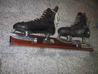
Skates
... recreational activity in the later nineteenth and early twentieth.... Historica) 'Ice-skating was a popular recreational activity ...Ice skates used to skate on Lake Catani. Ice skating was a popular activity for guest and visitors to Mt Buffalo. Ice skates were provided for hire by the the first Lessee of the Chalet, John Newton and also Norwegian born Hilda Samsing, who took over from him in 1919 and did much to pioneer and promote winter sports in the Victorian Alpine region . Ice cover on the Lake has not been sufficient for safe skating for many decades. 'After its initial popularity, skating at Mount Buffalo dwindled in the post-war years. According to Museum Victoria curator, Michelle Stevenson, few collections hold historic ice-skates, so any early examples identified in the Chalet collection will be important for their rarity." (Pg 94. Historica) 'Ice-skating was a popular recreational activity in the later nineteenth and early twentieth centuries...According to Michelle Stevenson, Australian Collections hold little material culture relating to its practice other than images and film. The few pairs of ice skates in the Chalet collection, which are in good condition, are important for their rarity as well as for illustrating the popularity of skating on Lake Catani prior to WW2.' Pair of black leather ice scates, mounted on wall. Skates feature white laces, metal blades and brown leather reinforcing area around laces and ankles.Boots are stffed with 1993 newsprint.On skate blade, "Made in Canada 11 1/3 CCM / Senior A" On boot sole , "Made by J Molony " plus worn name label. -
 Bendigo Historical Society Inc.
Map - Laminated map of Lake Eppalock at full capacity. Map 'E'
... of recreational activity until rainfall in the latter half of 2010... restricted the amount of recreational activity until rainfall ...John Perry Collection. Laminated map of Lake Eppalock at full capacity. Black and white. The dam was built by the State Rivers and Water Supply Commission of Victoria. The dam wall height is 45 metres (148 ft) and the main embankment is 1,041 metres (3,415 ft) long. At 100% capacity the dam wall was designed to hold back 304,651 megalitres (6.7014×10¹⁰ imp gal; 8.0480×10¹⁰ US gal) of water. The surface area of Lake Eppalock is 3,011 hectares (7,440 acres) and the catchment area is 2,124 square kilometres (820 sq mi). The controlled spillway is capable of discharging 8,040 cubic metres per second (284,000 cu ft/s). Lake Eppalock supplies both stock and domestic water to the Campaspe irrigation district. It also serves as a water supply to Bendigo and Heathcote and, in more recent times, Ballarat. The lake is a major attraction for those engaging in watersports, with a number of tourist parks and accommodation facilities available. Permissible activities on the lake include high-speed boating, water skiing, sailing, canoeing, fishing and swimming. The lake's water levels were low for approximately eight years between 2002 and 2010 during a prolonged drought, which restricted the amount of recreational activity until rainfall in the latter half of 2010 returned the lake to 100 percent capacity. Built between 1961 and 1964, Lake Eppalock remains the only water storage on the Campaspe River system.map, eppalock, water, dam, reservoir -
Bendigo Historical Society Inc.
Map - Black and white map pertaining to Lake Eppalock
... restricted the amount of recreational activity until rainfall... of recreational activity until rainfall in the latter half of 2010 ...John Perry Collection. Laminated copy of map relating to Lake Eppalock. Lists dwellings, ford crossings and bridges. The dam was built by the State Rivers and Water Supply Commission of Victoria. The dam wall height is 45 metres (148 ft) and the main embankment is 1,041 metres (3,415 ft) long. At 100% capacity the dam wall was designed to hold back 304,651 megalitres (6.7014×10¹⁰ imp gal; 8.0480×10¹⁰ US gal) of water. The surface area of Lake Eppalock is 3,011 hectares (7,440 acres) and the catchment area is 2,124 square kilometres (820 sq mi). The controlled spillway is capable of discharging 8,040 cubic metres per second (284,000 cu ft/s). Lake Eppalock supplies both stock and domestic water to the Campaspe irrigation district. It also serves as a water supply to Bendigo and Heathcote and, in more recent times, Ballarat. The lake is a major attraction for those engaging in watersports, with a number of tourist parks and accommodation facilities available. Permissible activities on the lake include high-speed boating, water skiing, sailing, canoeing, fishing and swimming. The lake's water levels were low for approximately eight years between 2002 and 2010 during a prolonged drought, which restricted the amount of recreational activity until rainfall in the latter half of 2010 returned the lake to 100 percent capacity. Built between 1961 and 1964, Lake Eppalock remains the only water storage on the Campaspe River system.map, water, dam, reservoir, eppalock -
Bendigo Historical Society Inc.
Map - Black and white map pertaining to Lake Eppalock
... restricted the amount of recreational activity until rainfall... of recreational activity until rainfall in the latter half of 2010 ...John Perry Collection. Laminated copy of map pertaining to Lake Eppalock. Gives details of dwellings, bridges and ford crossings. The dam was built by the State Rivers and Water Supply Commission of Victoria. The dam wall height is 45 metres (148 ft) and the main embankment is 1,041 metres (3,415 ft) long. At 100% capacity the dam wall was designed to hold back 304,651 megalitres (6.7014×10¹⁰ imp gal; 8.0480×10¹⁰ US gal) of water. The surface area of Lake Eppalock is 3,011 hectares (7,440 acres) and the catchment area is 2,124 square kilometres (820 sq mi). The controlled spillway is capable of discharging 8,040 cubic metres per second (284,000 cu ft/s). Lake Eppalock supplies both stock and domestic water to the Campaspe irrigation district. It also serves as a water supply to Bendigo and Heathcote and, in more recent times, Ballarat. The lake is a major attraction for those engaging in watersports, with a number of tourist parks and accommodation facilities available. Permissible activities on the lake include high-speed boating, water skiing, sailing, canoeing, fishing and swimming. The lake's water levels were low for approximately eight years between 2002 and 2010 during a prolonged drought, which restricted the amount of recreational activity until rainfall in the latter half of 2010 returned the lake to 100 percent capacity. Built between 1961 and 1964, Lake Eppalock remains the only water storage on the Campaspe River system.eppalock, map, water, dam, reservoir -
Bendigo Historical Society Inc.
Document - Legend to maps A, B and C for Lake Eppalock
... drought, which restricted the amount of recreational activity... of recreational activity until rainfall in the latter half of 2010 ...John Perry Collection. Laminated 'legend' for Maps A, B and C for Lake Eppalock also in this collection. Black and White definitions and descriptions of objects and markers found on maps. Circa 1951. The dam was built by the State Rivers and Water Supply Commission of Victoria. The dam wall height is 45 metres (148 ft) and the main embankment is 1,041 metres (3,415 ft) long. At 100% capacity the dam wall was designed to hold back 304,651 megalitres (6.7014×10¹⁰ imp gal; 8.0480×10¹⁰ US gal) of water. The surface area of Lake Eppalock is 3,011 hectares (7,440 acres) and the catchment area is 2,124 square kilometres (820 sq mi). The controlled spillway is capable of discharging 8,040 cubic metres per second (284,000 cu ft/s). Lake Eppalock supplies both stock and domestic water to the Campaspe irrigation district. It also serves as a water supply to Bendigo and Heathcote and, in more recent times, Ballarat. The lake is a major attraction for those engaging in watersports, with a number of tourist parks and accommodation facilities available. Permissible activities on the lake include high-speed boating, water skiing, sailing, canoeing, fishing and swimming. The lake's water levels were low for approximately eight years between 2002 and 2010 during a prolonged drought, which restricted the amount of recreational activity until rainfall in the latter half of 2010 returned the lake to 100 percent capacity. Built between 1961 and 1964, Lake Eppalock remains the only water storage on the Campaspe River system.map, water, dam, reservoir, eppalock -
Bendigo Historical Society Inc.
Map - Map of overlay of lake Eppalock at full capacity. Map 'C'
... restricted the amount of recreational activity until rainfall... drought, which restricted the amount of recreational activity ...John Perry collection. Map 'C'. Laminated map of overlay of Lake Eppalock at full capacity. Circa 1951. The dam was built by the State Rivers and Water Supply Commission of Victoria. The dam wall height is 45 metres (148 ft) and the main embankment is 1,041 metres (3,415 ft) long. At 100% capacity the dam wall was designed to hold back 304,651 megalitres (6.7014×10¹⁰ imp gal; 8.0480×10¹⁰ US gal) of water. The surface area of Lake Eppalock is 3,011 hectares (7,440 acres) and the catchment area is 2,124 square kilometres (820 sq mi). The controlled spillway is capable of discharging 8,040 cubic metres per second (284,000 cu ft/s). Lake Eppalock supplies both stock and domestic water to the Campaspe irrigation district. It also serves as a water supply to Bendigo and Heathcote and, in more recent times, Ballarat. The lake is a major attraction for those engaging in watersports, with a number of tourist parks and accommodation facilities available. Permissible activities on the lake include high-speed boating, water skiing, sailing, canoeing, fishing and swimming. The lake's water levels were low for approximately eight years between 2002 and 2010 during a prolonged drought, which restricted the amount of recreational activity until rainfall in the latter half of 2010 returned the lake to 100 percent capacity. Built between 1961 and 1964, Lake Eppalock remains the only water storage on the Campaspe River system.map, water, eppalock, dam, reservoir -
Bendigo Historical Society Inc.
Map - Laminated map of Lake Eppalock empty. Map 'D'
... of recreational activity until rainfall in the latter half of 2010... restricted the amount of recreational activity until rainfall ...John Perry Collection. Laminated map of Lake Eppalock empty. Map 'D'. Circa 1951. The dam was built by the State Rivers and Water Supply Commission of Victoria. The dam wall height is 45 metres (148 ft) and the main embankment is 1,041 metres (3,415 ft) long. At 100% capacity the dam wall was designed to hold back 304,651 megalitres (6.7014×10¹⁰ imp gal; 8.0480×10¹⁰ US gal) of water. The surface area of Lake Eppalock is 3,011 hectares (7,440 acres) and the catchment area is 2,124 square kilometres (820 sq mi). The controlled spillway is capable of discharging 8,040 cubic metres per second (284,000 cu ft/s). Lake Eppalock supplies both stock and domestic water to the Campaspe irrigation district. It also serves as a water supply to Bendigo and Heathcote and, in more recent times, Ballarat. The lake is a major attraction for those engaging in watersports, with a number of tourist parks and accommodation facilities available. Permissible activities on the lake include high-speed boating, water skiing, sailing, canoeing, fishing and swimming. The lake's water levels were low for approximately eight years between 2002 and 2010 during a prolonged drought, which restricted the amount of recreational activity until rainfall in the latter half of 2010 returned the lake to 100 percent capacity. Built between 1961 and 1964, Lake Eppalock remains the only water storage on the Campaspe River system.map, water, dam, reservoir, eppalock -
Bendigo Historical Society Inc.
Document - Collection of photographs from newspaper on a single page
... restricted the amount of recreational activity until rainfall... of recreational activity until rainfall in the latter half of 2010 ...John Perry Collection. Laminated copy of page from 'Weekly Times' newspaper, February, 1962. Nine images relating to establishing and building Eppalock Reservoir, 15 miles from Bendigo. The dam was built by the State Rivers and Water Supply Commission of Victoria. The dam wall height is 45 metres (148 ft) and the main embankment is 1,041 metres (3,415 ft) long. At 100% capacity the dam wall was designed to hold back 304,651 megalitres (6.7014×10¹⁰ imp gal; 8.0480×10¹⁰ US gal) of water. The surface area of Lake Eppalock is 3,011 hectares (7,440 acres) and the catchment area is 2,124 square kilometres (820 sq mi). The controlled spillway is capable of discharging 8,040 cubic metres per second (284,000 cu ft/s). Lake Eppalock supplies both stock and domestic water to the Campaspe irrigation district. It also serves as a water supply to Bendigo and Heathcote and, in more recent times, Ballarat. The lake is a major attraction for those engaging in watersports, with a number of tourist parks and accommodation facilities available. Permissible activities on the lake include high-speed boating, water skiing, sailing, canoeing, fishing and swimming. The lake's water levels were low for approximately eight years between 2002 and 2010 during a prolonged drought, which restricted the amount of recreational activity until rainfall in the latter half of 2010 returned the lake to 100 percent capacity. Built between 1961 and 1964, Lake Eppalock remains the only water storage on the Campaspe River system. dam, engineering, water, eppalock -
Bendigo Historical Society Inc.
Map - Laminated map of Lake Eppalock at full capacity
... of recreational activity until rainfall in the latter half of 2010... restricted the amount of recreational activity until rainfall ...John Perry Collection. Laminated copy of map of Lake Eppalock at full capacity. Had highlighter markings of old roads which appear to be still in use. The dam was built by the State Rivers and Water Supply Commission of Victoria. The dam wall height is 45 metres (148 ft) and the main embankment is 1,041 metres (3,415 ft) long. At 100% capacity the dam wall was designed to hold back 304,651 megalitres (6.7014×10¹⁰ imp gal; 8.0480×10¹⁰ US gal) of water. The surface area of Lake Eppalock is 3,011 hectares (7,440 acres) and the catchment area is 2,124 square kilometres (820 sq mi). The controlled spillway is capable of discharging 8,040 cubic metres per second (284,000 cu ft/s). Lake Eppalock supplies both stock and domestic water to the Campaspe irrigation district. It also serves as a water supply to Bendigo and Heathcote and, in more recent times, Ballarat. The lake is a major attraction for those engaging in watersports, with a number of tourist parks and accommodation facilities available. Permissible activities on the lake include high-speed boating, water skiing, sailing, canoeing, fishing and swimming. The lake's water levels were low for approximately eight years between 2002 and 2010 during a prolonged drought, which restricted the amount of recreational activity until rainfall in the latter half of 2010 returned the lake to 100 percent capacity. Built between 1961 and 1964, Lake Eppalock remains the only water storage on the Campaspe River system.map, water, dam, reservoir, eppalock -
Bendigo Historical Society Inc.
Map - Black and White map. Outline of Lake Eppalock. Map 'B'
... restricted the amount of recreational activity until rainfall... of recreational activity until rainfall in the latter half of 2010 ...John Perry Collection. Laminated copy black and white map. Map 'B'. Outline of Lake Eppalcok, overlayed on map. Circa 1951. The dam was built by the State Rivers and Water Supply Commission of Victoria. The dam wall height is 45 metres (148 ft) and the main embankment is 1,041 metres (3,415 ft) long. At 100% capacity the dam wall was designed to hold back 304,651 megalitres (6.7014×10¹⁰ imp gal; 8.0480×10¹⁰ US gal) of water. The surface area of Lake Eppalock is 3,011 hectares (7,440 acres) and the catchment area is 2,124 square kilometres (820 sq mi). The controlled spillway is capable of discharging 8,040 cubic metres per second (284,000 cu ft/s). Lake Eppalock supplies both stock and domestic water to the Campaspe irrigation district. It also serves as a water supply to Bendigo and Heathcote and, in more recent times, Ballarat. The lake is a major attraction for those engaging in watersports, with a number of tourist parks and accommodation facilities available. Permissible activities on the lake include high-speed boating, water skiing, sailing, canoeing, fishing and swimming. The lake's water levels were low for approximately eight years between 2002 and 2010 during a prolonged drought, which restricted the amount of recreational activity until rainfall in the latter half of 2010 returned the lake to 100 percent capacity. Built between 1961 and 1964, Lake Eppalock remains the only water storage on the Campaspe River system.map, water, dam, reservoir, eppalock -
Bendigo Historical Society Inc.
Map - General view of area of proposed construction of Lake Eppalock. Map 'A'
... drought, which restricted the amount of recreational activity... of recreational activity until rainfall in the latter half of 2010 ...John Perry Collection. Laminated map of proposed construction of Lake Eppalock. Map 'A'. Black and white map in laminate. Circa 1951. The dam was built by the State Rivers and Water Supply Commission of Victoria. The dam wall height is 45 metres (148 ft) and the main embankment is 1,041 metres (3,415 ft) long. At 100% capacity the dam wall was designed to hold back 304,651 megalitres (6.7014×10¹⁰ imp gal; 8.0480×10¹⁰ US gal) of water. The surface area of Lake Eppalock is 3,011 hectares (7,440 acres) and the catchment area is 2,124 square kilometres (820 sq mi). The controlled spillway is capable of discharging 8,040 cubic metres per second (284,000 cu ft/s). Lake Eppalock supplies both stock and domestic water to the Campaspe irrigation district. It also serves as a water supply to Bendigo and Heathcote and, in more recent times, Ballarat. The lake is a major attraction for those engaging in watersports, with a number of tourist parks and accommodation facilities available. Permissible activities on the lake include high-speed boating, water skiing, sailing, canoeing, fishing and swimming. The lake's water levels were low for approximately eight years between 2002 and 2010 during a prolonged drought, which restricted the amount of recreational activity until rainfall in the latter half of 2010 returned the lake to 100 percent capacity. Built between 1961 and 1964, Lake Eppalock remains the only water storage on the Campaspe River system.map, dam, water, weir, eppalock -
Bendigo Historical Society Inc.
Map - Laminated worksheet - identification of inundated artifacts at Lake Eppalock
... restricted the amount of recreational activity until rainfall... of recreational activity until rainfall in the latter half of 2010 ...John Perry Collection. Laminated copy of worksheet identifying inundated artifacts at Lake Eppalock when at 10% capacity. The dam was built by the State Rivers and Water Supply Commission of Victoria. The dam wall height is 45 metres (148 ft) and the main embankment is 1,041 metres (3,415 ft) long. At 100% capacity the dam wall was designed to hold back 304,651 megalitres (6.7014×10¹⁰ imp gal; 8.0480×10¹⁰ US gal) of water. The surface area of Lake Eppalock is 3,011 hectares (7,440 acres) and the catchment area is 2,124 square kilometres (820 sq mi). The controlled spillway is capable of discharging 8,040 cubic metres per second (284,000 cu ft/s). Lake Eppalock supplies both stock and domestic water to the Campaspe irrigation district. It also serves as a water supply to Bendigo and Heathcote and, in more recent times, Ballarat. The lake is a major attraction for those engaging in watersports, with a number of tourist parks and accommodation facilities available. Permissible activities on the lake include high-speed boating, water skiing, sailing, canoeing, fishing and swimming. The lake's water levels were low for approximately eight years between 2002 and 2010 during a prolonged drought, which restricted the amount of recreational activity until rainfall in the latter half of 2010 returned the lake to 100 percent capacity. Built between 1961 and 1964, Lake Eppalock remains the only water storage on the Campaspe River system.map, artifacts, eppalock, reservoir -
 Melbourne Legacy
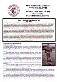
Document, MCC Library Fact Sheet Ronald Dale Barassi AM State Memorial Service, 2023
... and other recreational activities. A State Memorial Service... and other recreational activities. A State Memorial Service ...A fact sheet on Ron Barassi compiled by the MCC Library for the State Memorial Service held on 10 November. It lists Ron Barassi's football career. Australian football legend, former ‘Legacy Boy’ and Ambassador, Ronald Dale Barassi, AM passed away at the age of 87 on 6 September. Ron was forever grateful for Legacy’s support to him and his mother Elza. Throughout his life, as a Legacy Ambassador, Ron generously used his well-respected status and networks to promote the important work of Legacy. Ron came into Legacy’s care as a child when his father Ronald James Barassi was killed in action at Tobruk in 1941. Ron’s father was the first VFL footballer killed in World War II. Only 5 years old at the time, Ron later rose to be a star footballer for the Melbourne Football club like his father. Legacy assisted with his education and health expenses and supported him in attending youth camps and other recreational activities. A State Memorial Service for Ron was held at the Melbourne Cricket Ground on November 10. Staff from Legacy assisted at the service by handing out programmes and encouraging attendees to sign condolence books which have since been presented to the Barassi family. Legacy was honoured by the Barassi family’s request, in lieu of flowers, that members of the public make a donation to Legacy to assist families of veterans in need, a cause very dear to Ron’s heart. A record of the life of a man helped by Legacy.White A4 paper with printing created by the MCC Library for the State Memorial Service on 10 November 2023.ron barassi, football -
 Melbourne Legacy
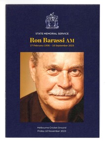
Booklet, Ronald Dale Barassi AM State Memorial Service, 2023
... and supported him in attending youth camps and other recreational... and other recreational activities. A State Memorial Service ...A programme for the State Memorial Service held on 10 November 2023 for Ron Barassi at the MCG. It lists the order of service and some facts on Ron's life. Australian football legend, former ‘Legacy Boy’ and Ambassador, Ronald Dale Barassi, AM passed away at the age of 87 on 6 September. Ron was forever grateful for Legacy’s support to him and his mother Elza. Throughout his life, as a Legacy Ambassador, Ron generously used his well-respected status and networks to promote the important work of Legacy. Ron came into Legacy’s care as a child when his father Ronald James Barassi was killed in action at Tobruk in 1941. Ron’s father was the first VFL footballer killed in World War II. Only 5 years old at the time, Ron later rose to be a star footballer for the Melbourne Football club like his father. Legacy assisted with his education and health expenses and supported him in attending youth camps and other recreational activities. A State Memorial Service for Ron was held at the Melbourne Cricket Ground on November 10. Staff from Legacy assisted at the service by handing out programmes and encouraging attendees to sign condolence books which have since been presented to the Barassi family. Legacy was honoured by the Barassi family’s request, in lieu of flowers, that members of the public make a donation to Legacy to assist families of veterans in need, a cause very dear to Ron’s heart. A record of the life of a man helped by Legacy.Coloured A5 booklet x 8 pages with printing created for the State Memorial Service on 10 November 2023.ron barassi, football -
 Kiewa Valley Historical Society
Maps - Bogong x2, Tawonga, Omeo, Dargo, Victoria and others, 1. Bogong Alpine Area; 2. Bogong 8324; 3. Tawonga Topographical; 4. Omeo 8433; 5. Dargo 8323; 6. Victoria State
... . Including: recreational activities, history, weather... in the Alpine National Park: Bogong Area. Including: recreational ...1. Bogong Alpine Area (outdoor Leisure Map. survey & Mapping Victoria, Government of Victoria, Edition 2, reprinted 1991 with an image of Mt. Feathertop on the front. Information for tourist in the Alpine National Park: Bogong Area. Including: recreational activities, history, weather and vegetation and a list of walks together with locality maps and photographs. The front cover has an image of Mt Feathertop against a blue sky with yellow writing 'Bogong Alpine Area', there is a yellow triangular block on the right hand top corner with black writing 'Outdoor Leisure Map. On the bottom edge is a block of yellow with black writing 'Survey & Mapping Victoria' and a light green map of Victoria with 'VICMSP' printed in white. 2. 8324 Bogong Victoria, Edition 1, Commonwealth of Australia 1981. A topographical Map: 1:100,000 scale (1 cm to 1 KM). Map has a red cover with white writing together with a white block and black writing and a map insert. 3. Tawonga Topographical Map - Forests Commission Victoria, / revised 5/9/77, DEG No. 68-G/399. A Tawonga 803 folded map in a beige colour with the back blank. 4. Omeo 8433 Victoria, Edition 1, Department of Natural Resources. The map has a red and white cover with black writing and a simple map of Australia at the bottom. 5. 8323 Dargo, Edition 1, Commonwealth of Australia. A red and white cover with a map insert. 6. Victoria State Map, Hema Maps, 2002. Hema Maps, State Map, colourful cover with a map of Australia and four tourism photographs. Scale 1: 850,000 An inscription handwritten in blue pen "Trappers Gap to Mitta Mitta 1" to 1 mile". There are some pen markings and notations of tracks.maps, bogong, omeo, tawonga, dargo, victoria, bogong alpine area -
Bendigo Historical Society Inc.
Document - Directions to Lake Eppalock with road descriptions and map
... of recreational activity until rainfall in the latter half of 2010... restricted the amount of recreational activity until rainfall ...John Perry Collection. Laminated copy of 'Directions to Lake Eppalock'. Gives directions in relationship of Lake Eppalock to Bendigo, Kyneton and Heathcote. Undated. Gives basic descriptions of bridges on lakebed, ford crossings on lakebed and inundated dwellings on lakebed. The dam was built by the State Rivers and Water Supply Commission of Victoria. The dam wall height is 45 metres (148 ft) and the main embankment is 1,041 metres (3,415 ft) long. At 100% capacity the dam wall was designed to hold back 304,651 megalitres (6.7014×10¹⁰ imp gal; 8.0480×10¹⁰ US gal) of water. The surface area of Lake Eppalock is 3,011 hectares (7,440 acres) and the catchment area is 2,124 square kilometres (820 sq mi). The controlled spillway is capable of discharging 8,040 cubic metres per second (284,000 cu ft/s). Lake Eppalock supplies both stock and domestic water to the Campaspe irrigation district. It also serves as a water supply to Bendigo and Heathcote and, in more recent times, Ballarat. The lake is a major attraction for those engaging in watersports, with a number of tourist parks and accommodation facilities available. Permissible activities on the lake include high-speed boating, water skiing, sailing, canoeing, fishing and swimming. The lake's water levels were low for approximately eight years between 2002 and 2010 during a prolonged drought, which restricted the amount of recreational activity until rainfall in the latter half of 2010 returned the lake to 100 percent capacity. Built between 1961 and 1964, Lake Eppalock remains the only water storage on the Campaspe River system.water, dam, directions, eppalock -
Bendigo Historical Society Inc.
Map - Map of Lake Eppalock shoreline when empty
... restricted the amount of recreational activity until rainfall... drought, which restricted the amount of recreational activity ...John Perry Collection. Laminated copy of map detailing Lake Eppalock shoreline when empty. Circa 1951. Has colored highlighter lines following roads leading to lake shoreline and various inundated old roads and tracks on lakebed. The dam was built by the State Rivers and Water Supply Commission of Victoria. The dam wall height is 45 metres (148 ft) and the main embankment is 1,041 metres (3,415 ft) long. At 100% capacity the dam wall was designed to hold back 304,651 megalitres (6.7014×10¹⁰ imp gal; 8.0480×10¹⁰ US gal) of water. The surface area of Lake Eppalock is 3,011 hectares (7,440 acres) and the catchment area is 2,124 square kilometres (820 sq mi). The controlled spillway is capable of discharging 8,040 cubic metres per second (284,000 cu ft/s). Lake Eppalock supplies both stock and domestic water to the Campaspe irrigation district. It also serves as a water supply to Bendigo and Heathcote and, in more recent times, Ballarat. The lake is a major attraction for those engaging in watersports, with a number of tourist parks and accommodation facilities available. Permissible activities on the lake include high-speed boating, water skiing, sailing, canoeing, fishing and swimming. The lake's water levels were low for approximately eight years between 2002 and 2010 during a prolonged drought, which restricted the amount of recreational activity until rainfall in the latter half of 2010 returned the lake to 100 percent capacity. Built between 1961 and 1964, Lake Eppalock remains the only water storage on the Campaspe River system.map, eppalock, reservoir, lake, water -
Bendigo Historical Society Inc.
Document - Black and white laminated photo of flow of water from Lake Eppalock. 1964
... of recreational activity until rainfall in the latter half of 2010... drought, which restricted the amount of recreational activity ...John Perry Collection. Laminated copy of photo of crowd watching flow of water from the opened valve at the wall of Lake Eppalock during its commissioning. March, 1964. Lake Eppalock was created by flooding to town of Wild Duck. The dam was built by the State Rivers and Water Supply Commission of Victoria. The dam wall height is 45 metres (148 ft) and the main embankment is 1,041 metres (3,415 ft) long. At 100% capacity the dam wall was designed to hold back 304,651 megalitres (6.7014×10¹⁰ imp gal; 8.0480×10¹⁰ US gal) of water. The surface area of Lake Eppalock is 3,011 hectares (7,440 acres) and the catchment area is 2,124 square kilometres (820 sq mi). The controlled spillway is capable of discharging 8,040 cubic metres per second (284,000 cu ft/s). Lake Eppalock supplies both stock and domestic water to the Campaspe irrigation district. It also serves as a water supply to Bendigo and Heathcote and, in more recent times, Ballarat. The lake is a major attraction for those engaging in watersports, with a number of tourist parks and accommodation facilities available. Permissible activities on the lake include high-speed boating, water skiing, sailing, canoeing, fishing and swimming. The lake's water levels were low for approximately eight years between 2002 and 2010 during a prolonged drought, which restricted the amount of recreational activity until rainfall in the latter half of 2010 returned the lake to 100 percent capacity. Built between 1961 and 1964, Lake Eppalock remains the only water storage on the Campaspe River system.water, dam, reservoir, eppalock, wild duck -
 Melbourne Legacy
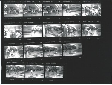
Photograph - Junior legatee outing, Bowling
... on outing for take part in recreational and educational activities... on outing for take part in recreational and educational activities ...These photos show a gathering of Legacy's handicapped dependents outside Legacy House. Also an outing to a bowling alley. Every month Legacy's handicapped dependents were invited to go on outing for take part in recreational and educational activities. These programmes aimed to develop independence and thus lessen the need for reliance on others for simple routine functions. Once a year there is a two week camp this also gave the mothers some respite. The photos are from approximately early 1990s.A record of the type of activities Legacy provided for the handicapped dependents of the Legacy families.Black and white proof sheet of photos taken at a HDC outing at a bowling alley and a gathering outside Legacy House.junior legatee outing, hdc, bowling -
 Melbourne Legacy
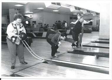
Photograph - Junior legatee outing, Bowling, 1994
... dependents were invited to go on outing for take part in recreational... invited to go on outing for take part in recreational ...This photo shows a few of Legacy's disabled dependents on an outing to a bowling alley. Every month Legacy's handicapped dependents were invited to go on outing for take part in recreational and educational activities. These programmes aimed to develop independence and thus lessen the need for reliance on others for simple routine functions. Once a year there is a two week camp this also gave the mothers some respite. The photos are from early 1994 as they were featured in the Answer newsletter in April 1994.A record of the type of activities Legacy provided for the handicapped dependents of the Legacy families. Names on a slip of paper have tried to identify the dependents. 'Russell Sister, Julie Kenny (?), David Mossof (?)'Black and white photo taken at a HDC outing at a bowling alley.junior legatee outing, bowling, answer, ddc, hdc -
 Eltham District Historical Society Inc
Audio - Audio Compact Cassette Tape, Audio Recording; Jock Read with Diana Bassett-Smith, 1990s
... games he played, memories of Eltham High School, recreational... games he played, memories of Eltham High School, recreational ...Oral history interview with Jock Read (1915- 2010) conducted by Diana Bassett-Smith of Eltham District Historical Society. Peter Bassett-Smith and possibly Gwen Orford also in attendance. The interview includes discussion of Jock's family history and connection to Eltham, including his attendance at Eltham State School starting 1921, childhood memories including games he played, memories of Eltham High School, recreational activities, milking, money earned, local transport, neighbours, effect of the Depression, local shops, involvement with the Church of England and more. Recording contains significant amount of noise. 0:00 Introduction including the clarification of Jock's name as Frances and backstory of his parents being from England 3:15- 5:00 Commences talking about home life and childhood 3:38 Talking about family immigrating to Australia His father immigrated to Australia when he was 6 4:05 Jock was born in and lived with his parents in Brunswick before moving to Eltham during the 1920s 4:55-7:44 Permanently moved to Eltham and started at Eltham Primary School in 1921 Talking about books used at school, and games played at school such as marbles, cricket and football 8:45 Moved into Eltham High School after finishing at Eltham Primary 9:50 Week and weekend activities including: Milking cows and doing milk runs on horseback before school 13:15 Most common mode of transport was using horse drawn vehicles and walking 14:50 Discusses impact of depression on family: Father had previously started a business but the depression had a large impact on that 16:10-18:00 Facilities that Jock had • Used hurricane lamps and candles- no electricity • Woodfire • Milk and bread were delivered • Greengrocer- George Bird? 25:22 Left Eltham high school in 1930 26:00 Begins discussing involvement with the church of England 31:46 Electricity did not come to Eltham until 1926 Jock described it as an exciting event 33:00-34:00 Describing the rented house, he was living in- small wooden cottage 35:00 Discussion around starting a mail run round areas of Eltham 38:40-42:35 Enlisted in the navy during WW2 • Navel cadets in 1934 • HMAS Vampire • Served as a seaman gunner Audio Compact Cassette Tape ACME C90 XHG Converted to MP3 file; 55.1MB, 0:42:35audio cassette, audio recording, diana bassett-smith, eltham, jock read, oral history, read family, elham primary school, eltham high school, eltham primary school, 1920s, brunswick, depression, church, st margaret's church, housing, ww2, second world war