Showing 82 items matching "recreational centre"
-
 Kiewa Valley Historical Society
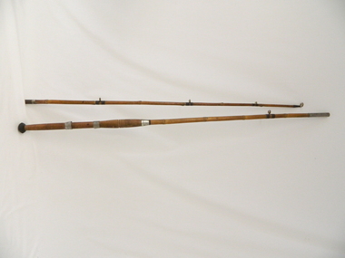
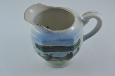
Rod Fishing, circa early 1900's
This bamboo fishing rod was used in the mid to late 1900's and demonstrates that local production of recreational fishing poles was at a high level and their demand was high. Imported recreational sporting goods from either the United Kingdom, the United States of America or Asia countries was due to the larger lead up times from these suppliers and the greater import costs from slower ocean supply ships. It was only after World War II that the trade influx from other countries has supplied cheaper goods. This recreational fishing pole is highly significant to the Kiewa Valley as it demonstrates that recreational fishing has been evolved from the need to supply a balanced diet by the early pioneer families of fish from the major Kiewa rivers. The ability of the Kiewa Valley rivers to provide a good fishing environment (high protein diet) for both early indigenous families and early pioneers was the important food source that provided for a balanced diet and the higher level of nutritious development of both body and mind. This two piece wooden fishing Rod is made from bamboo shafts or poles, one length thicker than the other. The smaller diameter shaft is the top end and fits into the longer thicker shaft at a stainless steel tube end.The smaller shaft has a stainless steel reinforcement ring where both shafts fit together. At the bottom end of the thick shaft is a black rubber "stopper" or "foot". There are two stainless steel rings, each with a reel holding "bulge" which allows for the the reel's "prongs" to be secured. The top ring has a greater diameter allowing it to move up and down the shaft/pole to secure the top "prong" firmly onto the shaft/pole.recreation, river, rod, fishing, industry, fish -
 Kiewa Valley Historical Society
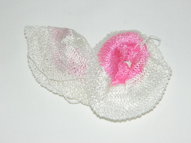
Mantle for Gas Lantern
Originally these mantles where produced to be used in gas street lights in Europe and North America cities.There use started in 1891. These mantles were used before electrical power street lighting was installed. They have been used ever since until safety concerns regarding radiation from their thorium infused particles made alternate mobile lamps more attractive. The age of open flame recreational lighting is fast coming to a close. The greater use of battery and generator powered lighting(ease of operation) has brought the costing of these alternative lighting to an acceptable level. The age of miniaturisation and volatility of the open flame has seen a greater swing to smaller and more stable lighting. These incandescent gas mantles were initially used in the Coleman White Gas LanternsThe Kiewa Valley, with its closeness to the Victorian Alps, allows greater opportunity for the "happy" campers to enjoy the outdoors. The lighting provided by the incandescent gas lamps allow the adventurer at heart to enjoy an alternative lifestyle and still having the comforts of "home" at their finger tips. The numerous camping facilities in the Kiewa Valley and the upper alpine region is testament that those living in the cities need a break from the day to day grind and go to a quieter and more spiritual environment. Artificial lighting, as provided by mobile apparatus, is highly valued by the urban gypsy. The outdoor recreational industry has significantly provided for, if only at holiday time, an industry that has a relatively high employment rate and beneficial to local communities.The gas mantle is in a fabric, pear shaped, of rayon fabric impregnated with cerium. It's appearance is similar to a very small fishing net. The fabric is very ply-able until it is heated by an open flame then it becomes more rigid and lets out an incandescent white light. Its colour is white to off white. It has a draw string fastened a t the bottom (to wrap around the flame source)lighting, gas, heating, camping, outdoor equipment lamp -
 Kiewa Valley Historical Society
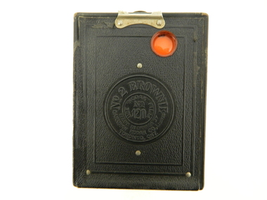
Camera Box Brownie, 4/8/1925
This item represents a period in time when there was the start by manufacturing industry for targeting the medium to lower socio and economic strata of the purchasing public. It was the beginning of cheaper mass produced items for the non professional (photographer in this instance) recreational minded public. The availability of low cost items was required by an ever increasing population hungering for the "do it yourself" amateur.This camera was owned by Margaret (Peg) Shefford nee Turner, who retired to Mount Beauty in the mid 1980s. The camera was purchased in 1920 and used up to the 1940's when her her daughter, Midge Clooney used it. When the Shefford family emigrated from England to Australia (1953), it was used to take photos of the ship voyage.This item is a Campfire Box Brownie. Model "F". It is a black vinyl covered tin box shell. It has a short leather hand strap (110mm) (stamped "BROWNIE") on the top side of the box, fastened by a metal stud at each end. There are two clasps holding the front and rear sides. Viewer (photo frame number) and lens (apertures) are on opposite sides.Stamped within a circular section on the back section is "No 2 BROWNIE" underneath,"MODEL F" in smaller letters "MADE IN CANADA BY CANADIAN KODAK Co., Limited, TORONTO, ONT". a smaller circle within has "USE KODAK FILM No_ 120"portable camera, photography, hobby, low cost camera -
 Kiewa Valley Historical Society
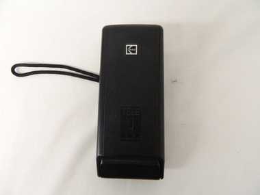
Camera Tele Ektra, Circa 1970s to 1980s
From the 1970's onward the relative isolation of regional areas was improving in "leaps and bounds". Social amenities, and life styles were changing at a great rate. Items such as this camera (recreational/life style/non professional) capture of the altering socio economic balance of rural based activities provided the catalyst for greater appreciation by city dwellers to the benefits of rural life. The greater levels of communicative avenues, especially the visual (photography, pictures, television and the internet), from the beginning of this period and throughout the time frame (1970 to the 2000s) has cut the major restraints of what was rural "isolationism".The significance of this type of camera, being a small two lens (normal, telescopic) and portable piece of equipment, allowed non professional tourists, locals or visitors to visually display the uniqueness of the Kiewa Valley and Alpine regions. This method of promotional and intimate visual reproduction of not only physical but also through personal involvement, of the photographer to the audience, a greater psychological impact, by the nature of intimacy involved. This type of photography is one of the most effective stimuli to promote the unique qualities of the Kiewa Valley region.This Item is dual lens (22mm,44mm) camera comprising of an elongated oblong shape, black hard plastic shell. It has a slightly rough surface(for a better fingers grip), two latches are located at the back, one to release the camera from its hinged protective cover and one to move to the next picture frame (film is within a cartridge).On swing cover "Kodak Tele 1 " on back in small print "MADE IN USA" On camera body "KODAK TELE EKTRA 1" underneath "CAMERA" and on slide switch(front) to change lenses:"Tele" and "Norm" kodak two lens camera, photographic hobby usa made camera -
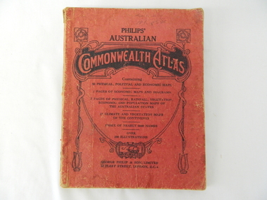 Kiewa Valley Historical Society
Atlas Australian Commonwealth, Philips' Australian Commonwealth Atlas, 1944
This atlas, printed in 1944, details not only the geographic and political boundaries of the world as it was at that time but also the snap shot of life of the time. This snap shot in time covers the major Australian cities, the major farming, grazing, industrial and sporting/recreational activities. Also there are snap shots of similar activities from other global areas. The period also covered World War II, detailed by a photo of "shell making", munitions, required by Australian soldiers. The great political and territorial changes made as a result of World War II can be clearly identified for example , Israel (the Jewish homeland). The various prewar colonies of major European nations.This atlas was used by children of a Kiewa Valley family and shows the value and the general educational exposure that these children had at this time. The rural setting and within the backdrop of a world war did not severely alter the life style of children in this region. The "news reels" shown in cinemas of cities and larger towns were the only visual realisations of major events of global significance available to these children. The information provided by this atlas allowed students to glimpse at what the "outside world" was. The majority of these students would possibly never see these regions for themselves. The great communication facilities of the late 1900s and beyond, was still only science fiction.This atlas has a thick (350 g/m) red cardboard cover with bold black lettering and shading. The cover is set out within a shield like frame. The shield is held up by two square markings, each with a four part circular pattern and a cord entwining two pendulum structures ending with a bowl figure at the bottom. There is a semi circular form enclosing a printed book contents list. The inside cover has the atlas title and contents and the publisher details. The atlas contain 56 pages of world and Australian maps, vegetation and rainfall maps. Within this atlas there are 27 double sided pages of black and white photographs depicting life styles, buildings, landscapes and prominent and significant to Australia males from 1652 to 1944. The pages are of approximately 200 g/m and have the yellow aged appearance.On front cover "Philips' Australian COMMONWEALTH ATLAS" and underneath "Containing" underneath "60 PHYSICAL, POLITICAL AND ECONOMIC MAPS". Publisher George Philip & Son, Limited 32 Fleet Street, London E.C. 4. Inside cover are: written, in freehand and in ink the following names and dates; "J.Muller Form V 1945", "L L Muller Form IV 1946", "N.J. Muller Form I + II + III 1948 +49 + 50" and "D Muller Form I 1949". also handwritten and in pencil is "Peter Leslie". On the last page is a small freehand sketch of Australia in biro.1940s school curriculum, rural education, 1940s atlas, australian atlas -
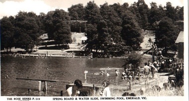 Emerald Museum & Nobelius Heritage Park
Postcard - B/W, Spring Board and Water Slide, Swimming Pool, Emerald, Vic
Recreational activities and provisions at Emerald Park Lake circa 1940sPostcard made from black and white photograph. Many bathers at Emerald Park Lake Swimming Pool. Springboard in foreground, water slide on right to the rear. FRONT: 'The Rose Series', P 519 COPYRIGHT' 'Springboard & Water Slide, Swimming Pool, Emerald, Vic.' REAR: Rose illustration in centre, flanked by 'POST CARD' and "The "Rose" Series Deluxe', 'A Real Photograph Produced in Australia'. Along left: 'Published by the Rose Stereograph Co., Armadale, Victoria'.emerald park lake, rose series, swimming pool -
 Federation University Historical Collection
Booklet, Ballarat School of Mines Planning Paper, 1978, 1978
Ballarat School of Mines is a predecessor institution of Federation University Australia.Two planning papers for the School of Mines and Industries, Ballarat. .1) Planning Paper 1978/7, June 1978. Includes linkage of Art and Chemistry buildings and the developmeny of sporting and recreational community project. Includes plan of the old Chemistry Building .2) Planning Paper 1978/8, June 1978. Includes SMB situation, educational philosophy, campus and accomodation, campus plan diagrams, student unionballarat school of mines, smb campus, tafe, planning paper, ballarat technical art school, old chemistry building, building linkage, overpass, white flat oval, ballarat youth centre, corbould hall, fire escape, motor mechanics, corbould hall, rural studies, campus plan, ballarat school of mines campus -
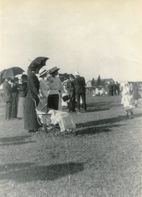 City of Moorabbin Historical Society (Operating the Box Cottage Museum)
Photograph (collection) - Bentleigh Recreational Reserve, Gathering of East Bentleigh Residents, c 1915
bentleigh, city of moorabbin, bentleigh recreational reserve, william burgess, fundraising, volunteers, sportbentleigh, city of moorabbin, bentleigh recreational reserve, william burgess, fundraising, volunteers, sport -
Port Melbourne Historical & Preservation Society
Photograph - Small group of people on Port 'n' South Living and Learning Centre tour, Dec 1994
Taken by a student on the tour. 2nd from right is tour leader Pat GRAINGER; Barbara GARDINER 3rd; Terry KEENAN (on right) took the group through the FC/CC facilitiesColour snapshot of small group on a Port 'n' South Living and Learning Centre tour ('Exploring Port Melbourne' class), taken at North Port oval, 1994. Kitchens building (Unichem) in backgroundInk, blurred: Dec 1994; pencil: Dec 1994 Living and Learning Centre Exploring Port Melbournesport - recreational grounds, education - other, barbara gardiner nee hegarty, terry keenan, pat grainger, south 'n' port living and learning centre -
 Port Melbourne Historical & Preservation Society
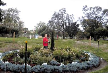
Photograph - Angela DREW at Garden City Reserve, Janet Bolitho, 2009
colour photograph Angela DREW in centre of "Fairy Garden" she created as part of the renewal of Garden City Reservebuilt environment - recreational facilities, garden city reserve, angela drew -
 Port Melbourne Historical & Preservation Society
Plan - Edwards Park improvements (Trugo Green), Port Melbourne, 1940s - 1950s
Although undated, this plan is probably from the late 1940s or early 1950s. Around this time Port Melbourne Council were looking to built a basketball court in Lagoon reserve, and shelters and a senior citizen's clubhouse in Edwards Park. PMHPS does to believe the basketball court shown in the plan was built but the Port Melbourne Senior Citizens and Trugo Club is at the location shown on the plan. A shelter is in a similar location to the one on the plan. A children's playground existed in that location shown in a photograph from the 1930s. The round flowerbed where the paths cross in the centre of the park in not in the 1930s photograph but is a current feature of Edwards Park.Plan drawing to scale, hand coloured, of proposed improvements to Edwards Park (Trugo Green), undated possibly late 1940s or early 1950s."City of Port Melbourne"built environment - recreational facilities, parks and gardens, sport - trugo, port melbourne trugo club, edwards park -
Port Melbourne Historical & Preservation Society
Document - Brochure, West Gate Bridge Progress Report, 1977 - 1979
.03 - West Gate Bridge Progress Report: August 1977 - large 4pp brochure detailing main span construction and Operations centre engineering - bridges, local government - city of port melbourne, industry - manufacturing, built environment - recreational facilities, built environment - industrial, lower yarra crossing authority, claude butcher, jack anderson, jack, pmcc electricity supply, port melbourne football ground, j kitchen and sons pty ltd, west gate bridge -
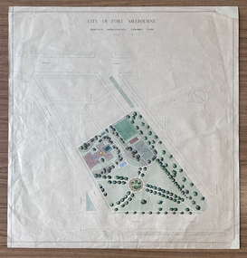
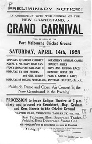 Port Melbourne Historical & Preservation Society
Document - Notice, Grand Carnival, opening new stand at Port Melbourne Cricket Ground, Grand Carnival, Apr 1928
Small handbill promoting a 'Grand Carnival' to celebrate the opening of the new grandstand at Port Melbourne Cricket Ground, 14 April 1928 - partially destroyed.Pen doodlings top left and centre right, and on back.celebrations fetes and exhibitions, sport - cricket, sport - australian rules football, port melbourne cricket club, sport - recreational grounds -
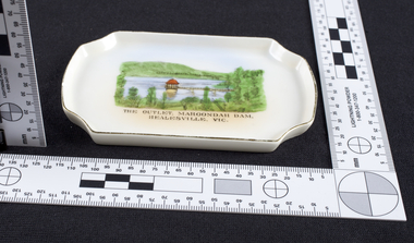 Melbourne Water
Dish, The Outlet at Maroondah Dam, Souvenir, c.1940
The Maroondah System was first and foremost developed as a functional component of Melbourne's Water Supply System. In addition to functionality, the Melbourne and Metropolitan Board of Works (MMBW) envisioned the Maroondah Reserve to be enjoyed aesthetically and recreationally by the public. This souvenir dish illustrates the realisation of the Maroondah System as a local recreational and tourist attraction in the early 20th century. The Maroondah Reserve gardens were landscaped with English-style ornamental stonework, exotic trees, flower beds and rose gardens. All features of the water supply system became widely celebrated as beauty spots that continue to be very popular to this day with tourists and locals alike. This souvenir is a product of that flourishing tourist trade. These water supply sites continue to enhance Melbourne’s charm and liveability and are now recognised as places of cultural and historic significance.This souvenir item represents an important historical aspect of the MMBW by demonstrating the popularity of its water asset sites as recreational places and tourist attractions, and although these sites are functional parts of the water supply system, they were also designed to be enjoyed by the public both aesthetically and recreationally. The souvenir dish is significant for its documentation of the Maroondah Water Supply System developed through the late nineteenth and early twentieth century, shaping the formative years of Melbourne. The dish is also historically significant for its association with the MMBW and is viewed as a noteworthy achievement of the organisation.Small white porcelain dish with silver trim, 120x75x10mm, with drawing printed in the centre and text reading, "The Outlet, Maroondah Dam, Healesville, Vic." Makers mark, Manufactured in Czechoslovakiamelbourne metropolitan board of works, mmbw, maroondah, outlet, melbourne water, scenic view, souvenir, porcelain, healesville -
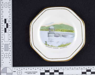 Melbourne Water
Dish, Maroondah Reservoir, Healesville Souvenir, 1930s-1940s
The Maroondah System was first and foremost developed as a functional component of Melbourne's Water Supply System. In addition to functionality, the Melbourne and Metropolitan Board of Works (MMBW) envisioned the Maroondah Reserve to be enjoyed aesthetically and recreationally by the public. This souvenir illustrates the realisation of the Maroondah System as a local recreational and tourist attraction in the early 20th century. The Maroondah Reserve gardens were landscaped with English-style ornamental stonework, exotic trees, flower beds and rose gardens. All features of the water supply system became widely celebrated as beauty spots that continue to be very popular to this day with tourists and locals alike. This souvenir is a product of that flourishing tourist trade. These water supply sites continue to enhance Melbourne’s charm and liveability and are now recognised as places of cultural and historic significance.Manufactured in England, this souvenir dish made from bone china with gold trim, features an illustration of the Maroondah Reservoir in the centre reading, “Maroondah Reservoir, Healesville”. On the back of the dish is the makers mark, Royal Stafford, one of the oldest pottery factories in Staffordshire, England. The Royal Stafford brand was established in 1845 and continues to provide high quality tableware in the present day. This souvenir item has been curated by Melbourne Water as it represents an important historical aspect of the organisation by demonstrating the popularity of its water asset sites as recreational places and tourist attractions, and although these sites are functional parts of the water supply system, they were also designed to be enjoyed by the public both aesthetically and recreationally. Souvenir dish made from bone china with gold trim, featuring an illustration of the Maroondah Reservoir in the centre reading, “Maroondah Reservoir, Healesville”.Makers mark, Royal Stafford.maroondah, healesville, dish, porcelain, melbourne metropolitan board of works, melbourne water, mmbw -
 Melbourne Water
Souvenir Porcelain Milk Jug, 1910-1930
The Maroondah System was first and foremost developed as a functional component of Melbourne's Water Supply System. In addition to functionality, the Melbourne and Metropolitan Board of Works (MMBW) envisioned the Maroondah Reserve to be enjoyed aesthetically and recreationally by the public. This souvenir illustrates the realisation of the Maroondah System as a local recreational and tourist attraction in the early 20th century. The Maroondah Reserve gardens were landscaped with English-style ornamental stonework, exotic trees, flower beds and rose gardens. All features of the water supply system became widely celebrated as beauty spots that continue to be very popular to this day with tourists and locals alike. This souvenir is a product of that flourishing tourist trade. These water supply sites continue to enhance Melbourne’s charm and liveability and are now recognised as places of cultural and historic significance.This souvenir milk jug has been curated by Melbourne Water as it represents an important historical aspect of the organisation by demonstrating the popularity of its water asset sites as recreational places and tourist attractions, and although these sites are functional parts of the water supply system, they were also designed to be enjoyed by the public both aesthetically and recreationally. Additionally, this item is aesthetically significant as it represents the style and design of the early 1900s.This souvenir white-glazed porcelain milk jug features gold trim and an illustration of the Maroondah Outlet in the centre, with the transfer “Maroondah Dam, Healesville, Vic”. -
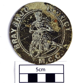 Sunshine and District Historical Society Incorporated
Club Badge, BRAYBROOK & DISTRICT MOTORCYCLE CLUB
This leather badge was made around circa 1950, and was sewn on to the leather jacket worn by Ian Downing. The Braybrook Motorcycle Club was formed in 1947 and on the 10th July 1950 merged with the Sunshine Club to form the Braybrook & District Motorcycle Club. In the mid 1960's the club disbanded and its activities were merged with the Newport Club. For a more detailed summary of the history of this motorcycle club, please refer to the information posted on this site for the item 'Club Sticker - BRAYBROOK & DISTRICT MOTORCYCLE CLUB'.The Braybrook & District Motorcycle Club has not existed in its own right since the mid 1960's. This particular badge is over 60 years old and is likely to be a relatively rare item. The badge serves as a reminder that the Braybrook & District Motorcycle Club was once part of the recreational scene in the Braybrook / Sunshine area.Brown circular shaped leather badge with white printed lettering around the perimeter of the badge, and with a white printed motorcycle and rider in the centre."BRAYBROOK & DISTRICT M.C.C."leather badge, braybrook & district motorcycle club, motorcycle club, braybrook. -
Whitehorse Historical Society Inc.
Article, Recreation now more accessible in Nunawading, 1992
A $50,000 modernisation of the Nunawading Recreation Centre gives more choice for recreational pursuits for local residents a $50,000 modernisation of the Nunawading Recreation Centre gives more choice for recreational pursuits for local residentsA $50,000 modernisation of the Nunawading Recreation Centre gives more choice for recreational pursuits for local residents a $50,000 modernisation of the Nunawading Recreation Centre gives more choice for recreational pursuits for local residents (photo: Don Sharp, John Harrowfield, Mayor, Savvas Athan)A $50,000 modernisation of the Nunawading Recreation Centre gives more choice for recreational pursuits for local residents a $50,000 modernisation of the Nunawading Recreation Centre gives more choice for recreational pursuits for local residents city of nunawading, athan, savvas, harrowfield, john, sharp, donald m, nunawading recreation centre -
Whitehorse Historical Society Inc.
Article, A great lake at Blackburn's heart, 15/01/1997 12:00:00 AM
Informative article on the various recreational activities in the Blackburn Lake Sanctuary.Informative article on the various recreational activities in the Blackburn Lake Sanctuary. In 1985 a group of volunteers formed the Friends of the Lake and established an information and education centre. The program director then was Dorothy Meagher (seen in picture on right).Informative article on the various recreational activities in the Blackburn Lake Sanctuary. blackburn lake sanctuary, friends of the lake, meagher, dorothy -
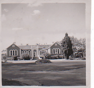 Department of Health and Human Services
Photograph, Front of building and roundabout of Pleasant Creek Special School - Stawell - Circa 1940 to 1950
Pleasant Creek Colony history in brief Warning about distressing information Patient information Disclaimer Source On this page: Pleasant Creek Colony history in brief Warning about distressing information Patient information Disclaimer Source Pleasant Creek Colony history in brief In 1861, the Pleasant Creek Hospital opened as a medical facility for the population of Stawell and district. Another building was added in 1904, Syme Ward for convalescent patients. In 1933, the facility was replaced by a newly-built hospital in the town of Stawell. In 1934, the Mental Hygiene Department acquired the old Pleasant Creek Hospital site and converted it to accommodate children with disabilities, which became Pleasant Creek Special School. The first residents (18 boys) were admitted in 1937 from Royal Park Depot. At the end of 1937, there were 98 children living at Pleasant Creek. In 1968 the Pleasant Creek Special School was renamed Pleasant Creek Training Centre, caring for people with intellectual disabilities. From the 1950s to the 1980s, there were several building developments: •1957, Lonsdale Unit expanded capacity to 113 •1969, Bellfield and Fyans Units increased numbers to 196 •1977, Alexandra Unit converted to recreational and lecture room facility. •1977, Day Centre, Nurses' Home and Clinical Services Administration buildings •1985, Nara Unit closed for renovations and residents moved to the previous staff living quarters. https://www.findingrecords.dhhs.vic.gov.au/CollectionResultsPage/Pleasant-Creek-Colony -
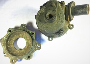 Queenscliffe Maritime Museum
Functional object - Vortex Pump
For over 45 years, Richard has used Wendy regularly for recreational fishing and occasional sailing out of Queenscliff. He has the original cotton canvas sails that were fitted on the boat when she was built, and which still are in working condition. Richard says that one of his favourite pastimes has been trolling for pike around Swan Island, close by Queenscliff, ensuring that the heritage of this Lacco-built boat fishing boat is preserved. In about 2015, Wendy underwent a rebuild including: a new centre-case, ribs and deck, and a new Yanmar engine. The works were done by Bryon Miller of Peninsula Wooden Boats. Wendy remains berthed, fore and aft, at Number 12 pile in front of Queenscliff Lonsdale Yacht Club. Well known couta boat in QueenscliffeAustralian made Kopsen vortex bilge pump.Kopsen Vortexcouta boats, 'wendy", bilge pump -
Kew Historical Society Inc
Journal, The Kewriosity Sheet Vol.1 No.1 : June 1979
What is THIS Kewriosity Sheet? Where did it come from? What's it for? / [Cr] Kaye Cole [Mayor of Kew] p1. What's doing in Kew during June / p1. Those vacant dates / p1. People wanted [Mount Royal Henry Pride Geriatric Centre] / p1. Pensioners' Association /p1. We need your news / p1. The birth of a village [Kew history] / H. Rolley p2. Limerick of the month / p2. Kew Chess Club -1979 Championships / p2. Kew Rovers start well [The Kew Rovers Football Club] / p2. The Copy Shop / p2. Area Playgroups / p2. Council News - Stradbroke Park Pavilion; Recreational Achievement of the Year Award; Kew Elder Citizens' Club / p2. Winter Sporting Activities Operating Throughout Kew / p2. Citizens' Advice Bureau / p2.The Kewriosity Sheet (1979-83) was first published in the City of Kew (Victoria) in June 1979 as a two-sided 'community newssheet'. It aimed to: 'share news about Kew happenings and Kew people, and to exchange ideas about living in Kew'. Later issues gradually evolved into a 4-page, quarto sized publication. The Kewriosity Sheet was superseded by the Kew Council publication 'Kewriosity' (1983-1994).non-fictionWhat is THIS Kewriosity Sheet? Where did it come from? What's it for? / [Cr] Kaye Cole [Mayor of Kew] p1. What's doing in Kew during June / p1. Those vacant dates / p1. People wanted [Mount Royal Henry Pride Geriatric Centre] / p1. Pensioners' Association /p1. We need your news / p1. The birth of a village [Kew history] / H. Rolley p2. Limerick of the month / p2. Kew Chess Club -1979 Championships / p2. Kew Rovers start well [The Kew Rovers Football Club] / p2. The Copy Shop / p2. Area Playgroups / p2. Council News - Stradbroke Park Pavilion; Recreational Achievement of the Year Award; Kew Elder Citizens' Club / p2. Winter Sporting Activities Operating Throughout Kew / p2. Citizens' Advice Bureau / p2.community publications --- kew (vic.), the kewriosity sheet, newsletters - kew (vic.) -
 Wodonga & District Historical Society Inc
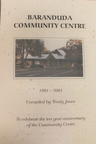
Booklet - Baranduda Community Centre 1991 - 2001, Trudy Jones
Baranduda is a rural area and, since the 1970s, a rural and residential locality formed under the authority of the Albury Wodonga Development Corporation. It is near the junction of Yackandandah Road and the Kiewa Valley Highway, 10 km south-east of Wodonga. This publication was compiled to celebrate the first 10 years of the Baranduda Community Centre. It documents the Centre's origins and anecdotes about its establishment and key personalities involved. Today it provides a variety of educational, recreational, leisure, cultural, social and community support programs including children's services, maternal and child health and immunisation clinics.non-fictionBaranduda is a rural area and, since the 1970s, a rural and residential locality formed under the authority of the Albury Wodonga Development Corporation. It is near the junction of Yackandandah Road and the Kiewa Valley Highway, 10 km south-east of Wodonga. This publication was compiled to celebrate the first 10 years of the Baranduda Community Centre. It documents the Centre's origins and anecdotes about its establishment and key personalities involved. Today it provides a variety of educational, recreational, leisure, cultural, social and community support programs including children's services, maternal and child health and immunisation clinics.baranduda communiity centre, baranduda -
 Sunbury Family History and Heritage Society Inc.
Photograph, Rosa McCall, The Nook, 25th September 1997
The photograph of The Nook is one of a series of photographs that was included in an exhibition organised by the former Sunbury & District Heritage Association in March 2001 and displayed in the George Evans Museum. Local; people were invited to submit photographs for the exhibition. The Nook is a major recreational area in Sunbury and over the years out has been an areas where grazing and cereal growing was practised before it became the original town's swimming area before the Aquatic Centre was opened in Ligar Street in 1966.Jacksons Creek at The Nook was the site of the original Sunbury Swimming Club for 49 Years from 1917 to 1966, when the Aquatic Centre opened in Ligar StreetA non-digital coloured photograph of river with trees growing along the banks and open ground across the river flats.the nook, swimming, sunbury swimming club -
 Eltham District Historical Society Inc
Photograph - Digital Photograph, Alan King, Edendale Farm Homestead, 29 January 2008
Edendale Farm is Nillumbik Shire Council's environment centre situated in Gastons Road, Eltham between the railway and the Diamond Creek. The homestead on the property was built in 1896 and is of historical significance, being the subject of a Heritage Overlay under the Nillumbik Planning Scheme. The Edendale property was originally part of an extensive land purchase in 1852 from the Crown by pioneer Eltham farmer Henry Stooke. He initially purchased 51 acres and later expanded his holdings by purchasing another three adjacent Crown allotments extending northerly from Josiah Holloway's Little Eltham subdivision. Despite clearing the land, Stooke did not build on this property, choosing to live on his property "Rosehill" at Lower Plenty. In 1896 Thomas Cool, Club Manager of the Victoria Coffee Palace in Melbourne purchased 7 acres of the original Stooke land and built the house now known as Edendale. Cool did not farm the land, instead using it as a gentleman’s residence, retiring to Eltham at weekends. In 1918 he purchased an additional 7 acres but in 1919 he sold the property. Later owners included J.W. Cox, the Gaston family and D. Mummery. In the 1980s the Eltham Shire Council purchased the site for use as a Council depot, but this use did not proceed. Subsequently, it was used as the Council pound. The Edendale Farm Pet Education and Retention Centre was established in the summer of 1988/1989 and was set up to replace the existing dog kennels with a high standard pet retention centre. The design style of the building was established to compliment the features of the existing house. It was equipped with 10 retention pens, a veterinary room and a pet education area where school children and other interested parties learnt about pet care procedures. It was later developed into a community farm and was run by an advisory committee and in 2000 it became an Environment Centre. In early 2006 an advisory committee was established for the development of a master plan for future development at Edendale Farm. The committee included Russell Yeoman, a former long-time shire planner and founding member of the Eltham District Historical Society. At the time of filming the Master Plan and future for Edendale was about continuing to develop Edendale as a centre of environment learning and looking at expanding displays and school program, running a lot more of life-long learning and workshops around sustainable living. Covered under Heritage Overlay, Nillumbik Planning Scheme. Published: Nillumbik Now and Then / Marguerite Marshall 2008; photographs Alan King with Marguerite Marshall.; p101 A sharp turn from busy Wattletree Road by the railway line, brings a surprise. Only 1.4 km from Eltham’s centre, sheep feed, blissfully unaware of the hectic suburban activity so close by. At the entrance to the 5.6ha Edendale Farm is another surprise. A work of art that looks like huge tree trunks transformed into bowler and top-hatted men. The Fences Act 1968 by Tony Trembath with Mark Cain and John Doyle, 1996, is classified by the National Trust of Australia as having Regional Significance. The title refers to a government act on disputes between neighbors over the placement of fences and boundaries. This takes a ‘wry swipe’ at a community divided by trivial squabbles. It also celebrates making do with limited resources.1 Further along on the left, the office wall is decorated with a massive Eltham Copper Butterfly, designed by Robert Tickner and made by school children with used plastic bottles and other waste material. Nillumbik Council runs Edendale as an Environmental Education Centre, to help preserve and enhance the local environment. As early as 1988 the former Eltham Shire Council realised Edendale’s importance in meeting people’s needs, particularly of children, to enjoy farmland. The centre, with the Eltham North Reserve to the north - including remnant bushland and open parkland - makes up the major part of the public open space for this area. The council considers this area will become increasingly important to the local community for recreational use.2 Educational programs aim to encourage community involvement to ensure the long-term rehabilitation and protection of natural bushland areas. Edendale is used by people of all ages - from school children to adults - for environmental programs and workshops, as well as for recreation, to enjoy the domestic animals and to picnic. Edendale is also home to the Environmental Works staff who manage reserves and roadsides and support Nillumbik Friends environmental groups. The Friends propagate plants at the nursery, which grows indigenous plants and sells these to the public.3 The centre demonstrates the sustainable living the farm teaches, with features like solar hot water and drive lighting and for the fireplace, logs of recycled cardboard. Edendale has had a varied history as a dog pound and even as a retreat for Thomas Cool, Club Manager of the Victoria Coffee Palace in Melbourne. His single-storey weatherboard house built in 1896, which still stands, was grander than most homes in Eltham. Although such buildings were common in many other parts of Melbourne, Eltham’s poverty and remoteness did not encourage such construction. The Victorian rectangular-shaped house, with a corrugated iron roof and veranda, has elegant large rooms, leadlight windows, ceiling roses, two bay windows and ornately carved wooden fireplace surrounds. Cool bought seven acres (2.8ha) from pioneer Eltham farmer Henry Stooke’s 200 acre (81ha) farm, which he had bought from the Crown in 1852. In 1918 Cool bought an extra seven acres (2.8ha) but in 1919 sold the estate to farmer John Cox. In 1933 Cox sold Edendale to Mrs Elizabeth Gaston, after whom the road leading to the centre was named. The property was owned by several Gaston family members, who called it Edendale, then by a police constable, Douglas Mummery, until the Shire of Eltham bought it in 1970. Oddly Edendale was known as Mummery’s for almost 20 years, although Mummery owned it only for a short time.4 The shire used Edendale as a dog pound until amalgamation with other municipalities in 1996. The pound then moved to the Yan Yean Road, Plenty site, which had been used by the former Diamond Valley Shire Council. To the west and north the centre is bounded by Diamond Creek and on the east by the Melbourne-Hurstbridge railway line. Part of the Research creek forms the centre’s southern boundary.This collection of almost 130 photos about places and people within the Shire of Nillumbik, an urban and rural municipality in Melbourne's north, contributes to an understanding of the history of the Shire. Published in 2008 immediately prior to the Black Saturday bushfires of February 7, 2009, it documents sites that were impacted, and in some cases destroyed by the fires. It includes photographs taken especially for the publication, creating a unique time capsule representing the Shire in the early 21st century. It remains the most recent comprehenesive publication devoted to the Shire's history connecting local residents to the past. nillumbik now and then (marshall-king) collection, edendale farm -
 Warrnambool and District Historical Society Inc.
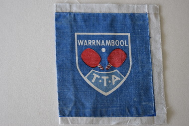
Badge Cotton, Warrnambool Table Tennis Association
The Warrnambool Table Tennis Association has been operating since 1958. The centre is located is in Cramer Street, Warrnambool in Albert Park. Many local churches have table tennis centres. It is a popular recreational activity. This badge is retained as memento of the Warrnambool Table Tennis Association. It is useful for display purposes.Cloth square most likely used for attaching to a uniform. The centre features a shield shaped white outline inside of which is text , two red table tennis bats and a white ball. Inside at the bottom of the shield is text enclosed in a further white outline. The background is blue. The above is printed on white cloth which surrounds the badge on all sides. WARRNAMBOOL T.T.A. table tennis -
 Vision Australia
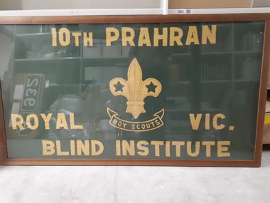
Flag - Object, 10th Prahran Royal Blind Institute Boy Scouts flag
Framed green flag with yellow stitched writing (10th Prahran Boy Scouts Royal Blind Institute) and a stitched Boy Scout emblem in the centre. In 1921, the new superintendent (S. Hedger) introduce a new range of activities for the children at the school, including the development of a Scout group.Green flag with yellow stitching in frameroyal victorian institute for the blind, recreational activities -
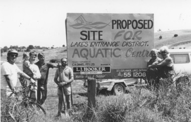 Lakes Entrance Historical Society
Photograph - Aquatic Centre, Lakes Post Newspaper, 1993
also one black and white photograph empty paddock with sign for proposed aquatic centre, with Council Offices at top of hill number in album 03515.02Black and white photograph taken at site of proposed aquatic centre Palmers Road, group of people beside prominent sign, Clark Warnock, Russell Smith with Kendra, Chris Newton, Ian McDougall, Lester Gedgin and Terry Barling. Lakes Entrance Victoriarecreational facilities, land -
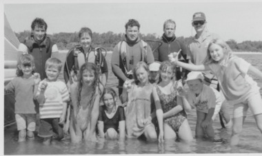 Lakes Entrance Historical Society
Photograph - Dive Club, Lakes Post Newspaper, 1994
... $5 entry fee from adults went toward Aquatic Centre ...Event occurred Saturday, children received free entry while $5 entry fee from adults went toward Aquatic CentreBlack and white photograph group of people old and young members of the Dive Club standing in foreshore waters participants in Treasure Hunt in Cunninghame Arm fundraising event for Aquatic Centre. Lakes Entrance Victoriarecreational facilities, fundraising -
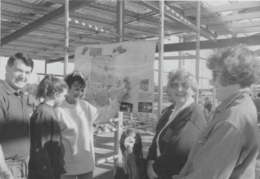 Lakes Entrance Historical Society
Photograph - Aquatic Centre, Lakes Post Newspaper, 1994
number in album 03516.02Black and white photograph group of people at work in progress building for Aquatic Centre, Marlene Battista, Joan Mitchelson, Ailsa Caratairs among group. Lakes Entrance Victoriavolunteering, recreational facilities