Showing 590 items
matching redevelopment
-
 Melbourne Legacy
Document - Document, minutes, Blamey House Redevelopment 1974, 1974
Fragment cut from the minutes of the Board meeting on 20/11/74, headed 'Blamey House Re-development', which recorded the presentation by Legatees Berg and Quayle to the Board for the redevelopment of Blamey House. The Board discussed the financial implications and resolved: (i) Residences sub-committee were asked to make a firm recommendation regarding the widows and residence children, (ii) Widows' Accommodation sub committee were asked to complete their study of providing accommodation for widows, (iii) Steering Committee-Accommodation for Widows was asked to look at the need for widows' accommodation, and (iv) Planning Committee was asked to coordinate the reports of the above sub-committees for presentation to the Board. In a file with documents pertaining to the residences.Gives an insight into the work involved in administering the residences.1 photocopy, black on white. Three holes punched for filing. Handwritten: 'o/.' and 'BOARD MEETING 20/11/74' top of page.residences, blamey house, committee -
 Eltham District Historical Society Inc
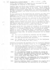
Photograph, Daryl Morrow, Redevelopment of former site of Hassall's Roadside Gallery, Main Road, Eltham, 10 July 2023
This historic site of Australia’s first open-air gallery is being redeveloped in 2023 for multi-housing fronting the Research Creek. In 1955, Ian and Joan Hassall moved to Eltham. They took a property on the corner of Zig Zag Road and Main Road, Eltham, north of the township (later known as 1215 Main Road). In July 1962, they opened their open-air gallery. Hassall’s Roadside Galley, “…cradled in the fold of hills to the north of Eltham” inspired by Ian’s own experience of exhibitions along the Embankment in London. The property included remnants of a stone quarry, paintings were hung on screens and removed at night. Various pedestals, that looked like giant mushrooms displayed sculpture, pottery, and jewellery. It had a small natural amphitheatre at the foot of a little sandstone cliff that fall away to the bed of a stream. To enter the gallery, a visitor crossed a small freestone bridge of oriental design, built by Hassall from local stone. The bridge spanned the stream flowing beneath great willow trees. Near the entrance wooden figures were displayed formed from pieces of local wood, said to speak to Ian Hassall’s sense of fun. Hassall’s Gallery was the first gallery of its kind in Australia. Ian became a full-time artist and when it first opened, he exhibited paintings he had made while touring the outback with writer and fellow Eltham resident Alan Marshall. He also exhibited other Australian artists over time including locals Lindsay Edward and Peter Glass.daryl morrow collection, eltham heights luxury living, hassalls roadside gallery, housing development, real estate development, research creek, 2023-07-10 -
 Eltham District Historical Society Inc
Photograph, Daryl Morrow, Redevelopment of former site of Hassall's Roadside Gallery, Main Road, Eltham, 13 July 2023
This historic site of Australia’s first open-air gallery is being redeveloped in 2023 for multi-housing fronting the Research Creek. In 1955, Ian and Joan Hassall moved to Eltham. They took a property on the corner of Zig Zag Road and Main Road, Eltham, north of the township (later known as 1215 Main Road). In July 1962, they opened their open-air gallery. Hassall’s Roadside Galley, “…cradled in the fold of hills to the north of Eltham” inspired by Ian’s own experience of exhibitions along the Embankment in London. The property included remnants of a stone quarry, paintings were hung on screens and removed at night. Various pedestals, that looked like giant mushrooms displayed sculpture, pottery, and jewellery. It had a small natural amphitheatre at the foot of a little sandstone cliff that fall away to the bed of a stream. To enter the gallery, a visitor crossed a small freestone bridge of oriental design, built by Hassall from local stone. The bridge spanned the stream flowing beneath great willow trees. Near the entrance wooden figures were displayed formed from pieces of local wood, said to speak to Ian Hassall’s sense of fun. Hassall’s Gallery was the first gallery of its kind in Australia. Ian became a full-time artist and when it first opened, he exhibited paintings he had made while touring the outback with writer and fellow Eltham resident Alan Marshall. He also exhibited other Australian artists over time including locals Lindsay Edward and Peter Glass.daryl morrow collection, eltham heights luxury living, hassalls roadside gallery, housing development, real estate development, research creek, 2023-07-13 -
 Greensborough Historical Society
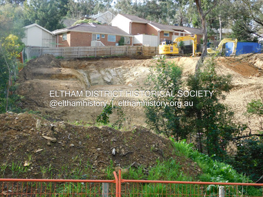
Photograph - Photograph - Digital Image, Marilyn Smith, Redevelopment of Gladstone and Sherbourne Roads Briar Hill, 04/09/2021
Digital images of houses at corner of Gladstone and Sherbourne Roads Briar Hill in 2021. This site was previously Crystal Car Wash.Part of a collection of miscellaneous historical images with a connection to the local area.Digital photographs. sherbourne road briar hill, gladstone road briar hill -
 Greensborough Historical Society
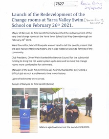
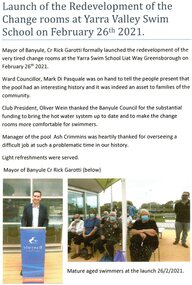
Document - Article, Rosie Bray, Launch of the redevelopment of the change rooms at Yarra Valley Swim School, 26/02/2021
Opening of the renovated change rooms at the Yarra Swim School, February 26th 20211 p.. two colour photographs, with separate prints of photographsyarra swim school, swimming pools greensborough -
 Greensborough Historical Society
Document - Report, Rosie Bray, Launch of the redevelopment of the change rooms at Yarra Valley Swim School 2021, 26/02/2021
Launch of the redeveloped change rooms at the Yarra Valley Swim School 26 February 20211 p. typescript and colour photographsyarra valley swim school, liat way greensborough, swimming pools greensborough -
 Greensborough Historical Society
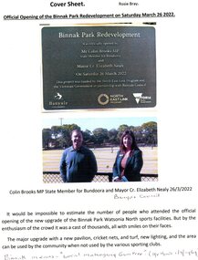
Article - Article and Leaflet, Rosie Bray et al, Official opening of the Binnak Park redevelopment on Saturday March 26 2022, July 2020 , November 2021 and March 2022
An upgrade at Binnak Park Watsonia will improve facilities for the Plenty Valley Cricket Club and Watsonia Sporting Club , which have been displaced from A K Lines Reserve by construction of the North East Link, Binnak Park to continue their activities5 p. comprising 4p. North East Link "Binnak Park Community Update" 2020, with Cover sheet by Rosie Bray and colour photograph of the park at openingbinnak park, banyule parks, binnak park watsonia, north east link -
 Greensborough Historical Society
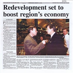
Newspaper Clipping, Diamond Valley News, Redevelopment set to boost region's economy, 23/08/1995
Premier Jeff Kennett opened the refurbished and extended Greensborough Plaza, which included a new Myer store..Newspaper clipping, black and white text and colour image.greensborough plaza, myer greensborough, jeff kennett -
 Greensborough Historical Society
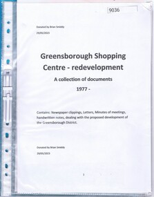
Document - Document Collection, Greensborough Shopping Centre redevelopment: a collection of documents 1977, 1977
Documents collected by Brian Smiddy from 1977. Includes newspaper clippings, handwritten notes, minutes of meetings dealing with the proposed development of the Greensborough District Centre and possible. Contains objections to this development.Plastic folder with clear cover and black plastic binding containing approx 6 documents and handwritten notes.brian smiddy, greensborough district centre, greensborough swimming pool -
 Eltham District Historical Society Inc
Photograph, Ruth H. Pendavingh, Redevelopment for Eltham Village and new Coles carpark
Originally contained in an A4 spiral bound blue plastic document folder with clear inserts of inkjet printouts, 3 images per page, 7 pages with explanatory notes and "Sue Law" at the top of each page.Low-resolution copy of colour photographconstruction, arthur street, carparks, eltham, coles store -
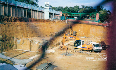
 Ringwood and District Historical Society
Book, Bryce Raworth, Heritage Impact Assessment - 1 Bedford Road, Ringwood, Victoria. Application for permit - Proposed Redevelopment - July 2021, 2021
A4 size wire-bound book compiled by Bryce RaworthINTRODUCTION: This heritage impact assessment (HIS) was prepared at the request of the City of Maroondah, the owner of the subject property at 1 Bedford Street (sic), Ringwood. It relates to a proposal to demolish the existing shop on the site and construct a multi-storey car park incorporating a commercial tenancy at the lower levels. It reviews the significance of the existing building on the site and the contribution it makes to the surrounding streetscapes, then comments on the heritage impacts of the proposed demolition in the context of the significance of the place and broader considerations. This office has previously provided an Historical Overview of the subject site (June 2020) and this assessment draws upon that previous research and analysis. The report has been prepared by Guy Murphy and Bryce Raworth. CONCLUSION: The proposed demolition of the former Blood Brothers Store at 1 Bedford Street (sic), Ringwood and the construction of a multi-storey car park on the enlarged site will result in the loss of some significance to the Heritage Overlay. The degree of loss is moderated by the partial intactness of the store, its modest character and the loss of its original setting, as well the proposal to implement a heritage interpretation strategy for the site. When considered in the context of the broader range of urban planning considerations and broader net community benefit, the proposed development is supported with respect to heritage impacts. -
 Ringwood and District Historical Society
Photographs, Redevelopment of Ringwood Salvation Citidel, Wantirna road, in 1997
-
 Galen Catholic College
Chapel Redevelopment, 2017
galen catholic college, galen college, chapel, school grounds & buildings, 2017 -
 Galen Catholic College
Galen Catholic College Main Office Redevelopment, 2015 - 2016
galen catholic college, galen college, main office, administration, reception, 2015, 2016 -
 Galen Catholic College
Junior Building Three & Wellbeing Centre Redevelopment, 2017
galen catholic college, galen college, junior school, library, senior library, 2017, wellbeing centre -
 Whitehorse Historical Society Inc.
Pamphlet, Proposed Whitehorse Centre Redevelopment, 2015
A pamphlet outlining proposed changes to the Whitehorse Centre.A pamphlet outlining proposed changes to the Whitehorse Centre and seeking community feedback. Architects; William Ross.A pamphlet outlining proposed changes to the Whitehorse Centre. whitehorse centre -
Whitehorse Historical Society Inc.
Article, Plum site set for redevelopment, 2001
A proposal for a 1162 square metre office on the former Blue Moon Fruit Co-operative Ltd site on Railway Road . Approved by Whitehorse council.A proposal for a 1162 square metre office on the former Blue Moon Fruit Co-operative Ltd site on Railway Road was approved by Whitehorse council.A proposal for a 1162 square metre office on the former Blue Moon Fruit Co-operative Ltd site on Railway Road . Approved by Whitehorse council.blue moon fruit co-operative ltd, railway road blackburn -
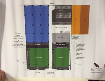 Kew Historical Society Inc
Plan, Kew Heights Sports Club Proposed Redevelopment 2012, 2012
Sports Clubs in Kew in the final decades of the 19th century and in the early 20th century were often umbrella organisations with facilities for a number of sports. Typically in Kew, this included teams in lawn bowls, tennis and croquet. The Kew Bowling Club was formed in 1880 while the privately owned Auburn Heights Recreation Club was opened in 1904. By 1998, the two Clubs decided to amalgamate at the Auburn Heights site in Barkers Road, forming the Kew Heights Sports Club. The combined club was itself taken over by the Melbourne Cricket Club in 2012 becoming MCC Kew Sports Club. In 2017 MCC Kew closed and its landholding was subsequently sold to Carey Baptist Grammar School. Both the Kew and Auburn Heights Clubs assembled important collections. These historically significant and large collections were donated to the Society in 2020. The collections include manuscripts, pictures, trophies, plans, honour boards etc. The combined collections of the four sporting clubs making up the collection number hundreds of items that are historically significant locally. They are also significant to the sporting history of the greater Melbourne area and to the sports of lawn bowls and tennis in Australia in the 19th and 20th centuries. The collection illuminates two of the Victorian historic themes - 'Building community life' through forming community organisations and 'Shaping cultural and creative life' by participating in sport and recreation.Architectural sketches on corflute of proposed designs for the new MCC Kew Sports Club by McIldowie Partners (Architects & Interior Designers), 2012.kew heights sports club - barkers road -- kew (vic.) -
University of Melbourne, Burnley Campus Archives
Plan, Redevelopment of the Rose Garden, 2002
Assignment by Student NB:501086 includes Plan, Scale 1/100 and Axonometric Drawing from Plan View 1/100.rose garden, burnley gardens -
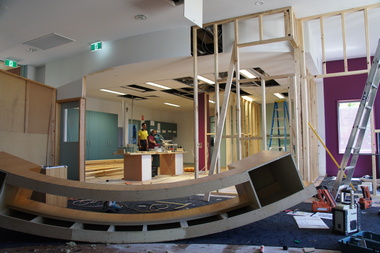
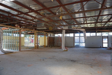
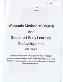 Greensborough Historical Society
Article - Folder, Rosie Bray, Watsonia Methodist Church and Goodstart Early Learning Redevelopment 2017-2021, 07/2024
Articles, photographs and newspaper clippings about Watsonia Methodist Church which was sold to develop Good Start Early Learning Centre in WatsoniaPlastic Folder with typed information and colour and black and white images plus colour photoswatsonia methodist church, good start early learning -
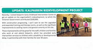 Greensborough Historical Society
Article - Newsletter Clipping, Colin Brooks, Update: Kalparrin Redevelopment Project, November 2020
Update on Kalparrin Early Childhood Intervention Centre which had received funds from the Victorian Government to redevelop amenities at the centre.Text with small colour photokalparrin, colin brooks -
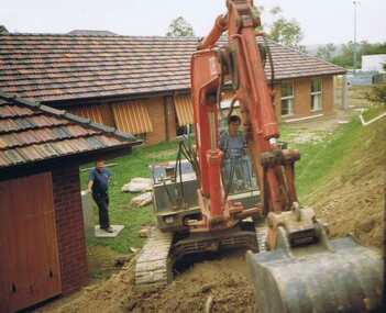 Greensborough Historical Society
Album - Photograph Album, Diamond Valley Community Hospital. Redevelopment program 1990/91. Volume II, 1990_12
Photographs include patients, staff, internal and external buildings and garden development. The Diamond Valley Community Hospital was established in 1942 in Grimshaw Street Greensborough. Due to financial circumstances, the hospital closed in 2000. This collection of photo albums is from the 1990s and was collected by staff. Photographs are not named. Albums may be accessed at the GHS Resource Centre. This volume is numbered 7.As the Diamond Valley Community Hospital is now closed, this collection of albums records some of the people involved.Photo album with black cover. 25 pages, 125 photographs of varying sizes. Title handwritten and pasted on cover.diamond valley community hospital, greensborough, dvch -
Port Melbourne Historical & Preservation Society
Photograph - Composite image of market shops in Bay Street, Port Melbourne, prior to redevelopment as Coles supermarket, 1980s
Compiled of photos taken as reference by the Engineer's office before redevelopment began.Composite photo of market shops in Bay Street 1980s, prior to redevelopment as Coles supermarket. Made up of six photos.built environment - commercial, business and traders - grocers and supermarkets, messina (stove and merchandise trader), jeff lanagan (men, swear dealer), mensland, cassidy's (wool shop), port sport store (formerly newsagent), hogan's pie shop, j. e. earl (hardware and timber) -
Whitehorse Historical Society Inc.
Pamphlet, Creating a New Strathdon Community, 2001
Creating a New Strathdon Community.Creating a New Strathdon Community: A vision for the redevelopment of Strathdon's Jolimont Road site, contains Plans of Proposals for site development.Creating a New Strathdon Community.strathdon community, strathdon orchard, matheson, charles, matheson mary, aged people -
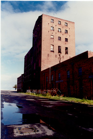 Port Melbourne Historical & Preservation Society
Photograph - Harper's factory buildings, Beach and Rouse Streets, Port Melbourne. Awaiting redevelopment, 1980s
Harper factory buildings on Beach and Rouse Streets (colour photo). c 1980s External view of some of the buildings awaiting redevelopmentbuilt environment, built environment - commercial, harper's, redevelopment -
 Port Melbourne Historical & Preservation Society
Photograph - Harper's factory buildings, Beach and Rouse Streets, Port Melbourne. Awaiting redevelopment, 1980s
Harper factory buildings on Beach and Rouse Streets (colour photo). c 1980s External view on Beach street of some of the buildings awaiting redevelopment. built environment, built environment - commercial, harper's, redevelopment -
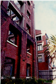
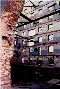 Port Melbourne Historical & Preservation Society
Photograph - Harper's factory buildings, Beach and Rouse Streets, Port Melbourne. Awaiting redevelopment, 1980s
Harper factory buildings on Beach and Rouse Streets (colour photo). c 1980s Internal view of some of the buildings awaiting redevelopment. Bare shell with supporting steel beams in placebuilt environment, built environment - commercial, harper's, redevelopment -
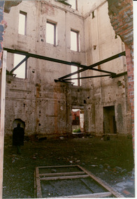 Port Melbourne Historical & Preservation Society
Photograph - Harper's factory buildings, Beach and Rouse Streets, Port Melbourne. Awaiting redevelopment, 1980s
Harper factory buildings on Beach and Rouse Streets (colour photo). c 1980s Internal view of some of the buildings awaiting redevelopment. Bare shell with supporting steel beams in place. Man inspecting interiorbuilt environment, built environment - commercial, harper's, redevelopment -
Clunes Museum
Document - ARCHIVE, JUDITH FAWCETT - PRESIDENT CLUNES MUSEUM
.1ONE SKETCH OF THE FORMER CLUNES MUSEUM ATTACHED TO TWO A4 PAGES OF AN IDEAFOR THE REDEVELOPMENT OF THE SITE BY MCAULEY DATED 3 JULY 2004 .2 BLUE FOLDER - CONTAINS DOCUMENTS RELATING TO THE MUSEUM ACCREDITATION 2007 .3 ARCHIVE OF DOCUMENTS PREVIOUSLY HELD BY JUDITH FAWCETT IN HER CAPACITY OF PRESIDENT OF CLUNES MUSEUMredevelopment, accreditation, judith fawcett -
Surrey Hills Historical Society Collection
Planning report, City of Boroondara, City of Boroondara planning report re 171 Union Road, Surrey Hills, 19/07/2004
171 Union Road was part of the Thomas Zeplin estate. It originally had a Victorian house on it built by the Zeplin family. This was leased by Dr Percy Liddle and then Dr James Landells Blakie. Dr Blakie purchased land diagonally opposite at 174 Union Road and had a purpose-built home / surgery constructed. Later the site was occupied by COR then a BP petrol station.A detailed proposal regarding the redevelopment of the petrol station site on the corner of Union Road and Montrose Street, Surrey Hills into a 2 storey office and shop building with basement parking and access from Montrose Street. It includes attachments showing plans, elevations and details regarding objectors. The application was granted subject to additional conditions being met. union road, redevelopment, shops, town planning